
Where Flight Simulation Enthusiasts Gather from Around the World!
AVSIM Library - Search Results

| Category: Flight Simulator 2004 - Aircraft Repaints, Textures and Modifications | |
| Euroflyer Airways Airbus A320 - 232 |

|
File Description:
FS2004 Aircraft. Euroflyer A320 G-EURC. This aircraft is used on Euroflyers services to Dublin, Jersey and Frankfurt. See www.euroflyer.tk for more info.
| Filename: | Euroflyer_Airways_Airbus_A320__232.zip |
| License: | Freeware |
| Added: | 1st December 2004, 23:23:28 |
| Downloads: | 330 |
| Author: | James White, iFDG |
| Size: | 5.51 MB |
| Category: Flight Simulator X - Scenery | |
| Mesh South America / MeSA Islands |
|
File Description:
FSX Mesh South America Project:
This terrain mesh file is a part of a whole project covering all the Continent of South America and some islands, divided in tiles identified in a map by its column (letters) and rows (numbers).
Those files were multi-LOD compiled from 90m SRTM2 source data, reprocessed with 3DEM to remove voids and spikes, providing a 76.4m (LOD9) horizontal resolution topography intended for use only in FSX updated with SP1.
Although not well documented, to improve performance, the updated FSX loads DEM files in threads and only the closer terrain (about 5 NM from the point of view) is rendered in high detail, while at far distances FSX shows up its default low resolution mesh, when there is not a third part terrain mesh compiled in all others intermediate level of details (multi-LOD).
THIS FILE: FSX_MeSA_Islands (Ascencion, Georgia, Gough and Trindade)
| Filename: | Mesh_South_America__MeSA_Islands.zip |
| License: | Freeware |
| Added: | 10th June 2007, 23:59:44 |
| Downloads: | 1,138 |
| Author: | Hely Heck Junior and José Lôbo |
| Size: | 2.75 MB |
| Category: Flight Simulator 2004 - Scenery | |
| Argentina ,Valle de Punilla/ Lago San Roque Area, v1.0 |
|
Images related to this file:
File Description:
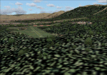
LOD 13 mesh and scenery of the Sierra de Cordoba, Argentina, area. Includes Santa Maria de Punilla and Villa Carlos Paz airstrips as well as a reconfiguration of La Cumbre(SACC) to fit the new mesh.
Roads, rivers and landmarks have been placed to aid VFR pilots
Includes Voicepack modifications for the ICAO identifiers (requires EditVoicepack).
| Filename: | Argentina_Valle_de_Punilla_Lago_San_Roque_Area_v10.zip |
| License: | Freeware, limited distribution |
| Added: | 16th May 2010, 09:57:58 |
| Downloads: | 609 |
| Author: | Alf B. Meier |
| Size: | 7.83 MB |
| Category: Flight Simulator X - AFCAD Files | |
| Central Jersey Regional Airport (47N), NJ |
|
File Description:
Located 01 miles S of Manville, New Jersey on 119 acres of land, Central Jersey Regional Airport is a public asphalt strip. Hangars and tiedowns are offered for transient craft. The open hangar at the north of the airport is available for parking - it can be a bit of a tight fit taxiing in so I have disabled collision with the two planes nearby. You can also select the DOCK parking space to start inside the hangar. Fuel is available on the north tarmac by the fuel truck in front of the hangar, and on the south tarmac by the fuel tank. Trees are summertime ONLY.
Scenery constructed with use of satellite images/streetview, the author has not been there in person.
This scenery is meant to be used in conjunction with MegaScenery Earth New Jersey/Delaware 001. It is not required, but apron use is minimized to allow satellite scenery to show through as much as possible, and objects are placed based on the MSE textures - lack of it may make scenery look out of place.
| Filename: | Central_Jersey_Regional_Airport_47N_NJ.zip |
| License: | Freeware |
| Added: | 25th November 2010, 14:15:25 |
| Downloads: | 295 |
| Author: | Drew Sikora |
| Size: | 1.92 MB |
| Category: Flight Simulator 2004 - Scenery | |
| Himalayas LOD9 Base Mesh, Volume 5 - Hindu Kush and Pamir |
|
Images related to this file:
File Description:
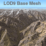
Detailed terrain mesh of the Hindu Kush and Pamir Ranges, N32-40 E70-76. The files in this package are based on Shuttle Radar (SRTM) Version 2 data but with many of the void areas, especially the most significant sections, filled with elevation data generated from topographic maps by Jonathan de Ferranti. While Jonathan's work is unrelated to flight simulation he kindly gave me permission to compile his data for use in FS. The result is a wonderful improvement in detail and accuracy over any existing mesh file, freeware or commercial, based on SRTM or DTED data alone.
Due to the large area of the Himalayas I've compiled the source data as two separate series: the "Himalayan Peaks" series covers prominent mountains and ranges in higher detail and locally overrides any existing LOD9 terrain mesh. In addition, the LOD9 "base mesh" series, with LOD8 and LOD7 "buffer" mesh files, covering the entire Himalayas, is meant for those who do not yet have an add-on terrain mesh of these beautiful mountains.
| Filename: | Himalayas_LOD9_Base_Mesh_Volume_5__Hindu_Kush_and_.zip |
| License: | Freeware, limited distribution |
| Added: | 29th May 2010, 08:57:29 |
| Downloads: | 7,602 |
| Author: | Holger Sandmann, Jonathan de Ferranti |
| Size: | 85.72 MB |
| Category: Flight Simulator 2004 - Scenery | |
| NZ Rural Airstrips, v3 |
|
Images related to this file:
File Description:
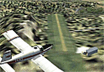
Replaces my previous versions. 9 more strips included. Gisborne area. Requires Christian Stock's payware NZ mesh in the form of "Mountains of New Zealand" and topo in the form of "Lakes and Rivers of New Zealand".
| Filename: | NZ_Rural_Airstrips_v3.zip |
| License: | Freeware |
| Added: | 17th April 2010, 16:18:18 |
| Downloads: | 147 |
| Author: | Godfrey Tier |
| Size: | 2.37 MB |
| Category: Flight Simulator X - Missions | |
| Appalachian Trail Missions |
|
Images related to this file:
File Description:

Welcome to the Appalachian Trail. Fly the historical Appalachian Trail by each state. Your Mission is to find all the shelters and Point of Interest along the trail. Start the missions with Georgia then North Carolina, Tennessee, Virginia, Maryland, Pennsylvania, New Jersey, New York, Connecticut, Massachusetts, Vermont, New Hampshire ending with and Maine. You will get a reward for each state and a trophy when you completed all the states in order.
| Filename: | Appalachian_Trail_Missions.zip |
| License: | Freeware |
| Added: | 24th May 2021, 21:12:08 |
| Downloads: | 159 |
| Author: | David Crandall |
| Size: | 171.89 MB |
| Category: Flight Simulator X - Aircraft Repaints, Textures and Modifications | |
| Aegean Airlines NC Airbus A321 |
|
Images related to this file:
File Description:

10 Repaints for the Aerosoft Airbus A321 in Aegean Airlines new livery, 5 have Sharklets
| Filename: | Aegean_Airlines_NC_Airbus_A321.zip |
| License: | Freeware |
| Added: | 14th May 2020, 17:36:50 |
| Downloads: | 769 |
| Author: | Lee Grant |
| Size: | 56.96 MB |
| Category: Flight Simulator X - AFCAD Files | |
| Emmanuel Airport (04NJ), NJ |
|
File Description:
Located 03 miles W of Elmer, New Jersey, Emmanuel Airport is a privately-owned turf airstrip. This scenery properly aligns the turf strip and adds surrounding trees and houses. You can park in the open hangar by the house on the west end of the airport. Trees are summer ONLY.
Scenery constructed with use of satellite images/streetview, the author has not been there in person.
This scenery is meant to be used in conjunction with MegaScenery Earth New Jersey/Delaware 004. It is not required, but apron use is minimized to allow satellite scenery to show through as much as possible, and objects are placed based on the MSE textures - lack of it may make scenery look out of place.
| Filename: | Emmanuel_Airport_04NJ_NJ.zip |
| License: | Freeware |
| Added: | 21st October 2010, 23:23:23 |
| Downloads: | 169 |
| Author: | Drew Sikora |
| Size: | 321.87 KB |
| Category: Flight Simulator X - AFCAD Files | |
| Dix Field Airport (0NJ6), NJ |
|
File Description:
This another airport I've excised from the default scenery by simply removing the turf runway that was visible over some marshy land. Dix Field is a private strip located 01 miles N of Linwood, New Jersey on 250 acres of land. No facilities or anything, so it's not a big loss.
Scenery constructed with use of satellite images/streetview, the author has not been there in person.
This scenery is meant to be used in conjunction with MegaScenery Earth New Jersey/Delaware 003. It is not required, but apron use is minimized to allow satellite scenery to show through as much as possible, and objects are placed based on the MSE textures - lack of it may make scenery look out of place.
| Filename: | Dix_Field_Airport_0NJ6_NJ.zip |
| License: | Freeware |
| Added: | 21st October 2010, 23:24:08 |
| Downloads: | 180 |
| Author: | Drew Sikora |
| Size: | 125.73 KB |
© 2001-2026 AVSIM Online
All Rights Reserved
Privacy Policy |