
Where Flight Simulation Enthusiasts Gather from Around the World!
AVSIM Library - Search Results

| Category: Flight Simulator 2004 - Scenery | |
| Phoenix, Arizona 30 Meter Terrain Mesh Scenery |

|
File Description:
Mesh Scenery for Microsoft Flight Simulator 2004 and 2002.USGS NED 30 meter (1 arc-second), resampled to LOD10 (38.2 meters). This terrain mesh is centered at Phoenix, Arizona. Coverage area: From about West 111° to West 113° and North 33° to North 34°.
| Filename: | Phoenix_Arizona_30_Meter_Terrain_Mesh_Scenery.zip |
| License: | Freeware |
| Added: | 3rd January 2004, 19:53:36 |
| Downloads: | 3,718 |
| Author: | Phil Cruikshank |
| Size: | 4.66 MB |
| Category: Flight Simulator X - Scenery | |
| 3U2 Johnson Creek Airport |
|
File Description:
"Johnson Creek Airport (FAA LID: 3U2) is a grass airstrip located in Central Idaho three miles (5 km) south of Yellow Pine, a village in Valley County, Idaho, United States. It is managed by the Idaho Division of Aeronautics of the Idaho Transportation Department. A caretaker resides at the field, and as a result, the turf runway is well cared for. Johnson Creek is in the category of backcountry airstrips, and is popular with pilots who enjoy airplane camping." - Wikipedia
This FSX rendition includes volumetric grass, static aircraft, 1 meter/pixel photoscenery, 10 meter mesh, full autogen annotation, and is color corrected and blended into the surrounding scenery.
| Filename: | 3U2_Johnson_Creek_Airport.zip |
| License: | Freeware, limited distribution |
| Added: | 22nd July 2012, 20:11:57 |
| Downloads: | 898 |
| Author: | Orion Lyau |
| Size: | 12.69 MB |
| Category: Flight Simulator 2002 - Scenery | |
| Guam 10 M Terrain Mesh |
|
File Description:
Shareware - 10 Meter of Resolution Mesh Scenery Guam. Designed with Usgs 10 m of Resolution Dem offer the best levels of details ever achived in any mesh Scenery. This is a low price shareware pack only at US$ 5.99. Registration password will be email to your address immediately after you have registered.
| Filename: | Guam_10_M_Terrain_Mesh.zip |
| License: | Check within download |
| Added: | 26th June 2002, 22:53:37 |
| Downloads: | 1,146 |
| Author: | Raimondo Taburet |
| Size: | 455.28 KB |
| Category: Flight Simulator X - Scenery | |
| Dupont airfield New Jersey |
|
Images related to this file:
File Description:
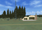
Presenting Dupont Airport in Delaware for FSX.
This scenery was done by request of Anthony Necastro, a good friend of ours on our Skype 'family' of friends,who often flew out of this airfield.
This airfield closed circa 1958. Lindberg landed here once. There are a number of planes needed for the traffic files. These are in a separate zip called Dupont-traffic-planes.zip.
If you install those also, you will see a good number of planes taking off around 12 noon. One or two go around and land again. Others go to New Castle a short distance away, and return soon.
My e-mail is in this download for hlep or comments. Bob Lacy
| Filename: | Dupont_airfield_New_Jersey.zip |
| License: | Freeware |
| Added: | 26th April 2016, 00:31:23 |
| Downloads: | 156 |
| Author: | Robert Lacy |
| Size: | 19.05 MB |
| Category: Flight Simulator 2004 - Scenery | |
| More New Jersey Airports |
|
File Description:
FS2004 Scenery - This file contains 5 more New Jersey Airports. Enjoy flying from one to another. You can visit Bucks Airport (00N), Redwing Airport (2N6), Marlboro Airport (2N8, Now Closed), Hackettstown Airport (N05) and Li Calzi Airport (N50). There is information on all the airports in the readme file. Created with Instant Scenery. The usual EZ Scenery Libraries are required. In collaboration with Ray Lunning, this scenery was created by John B. Loney, Jr.
| Filename: | More_New_Jersey_Airports.zip |
| License: | Freeware, limited distribution |
| Added: | 16th December 2007, 16:16:38 |
| Downloads: | 740 |
| Author: | John B. Loney, Jr. |
| Size: | 577.69 KB |
| Category: Flight Simulator 2004 - Scenery | |
| New Jersey Vol 3 |
|
Images related to this file:
File Description:
Re-upload. New Jersey Vol 3: Six very small bush airfields located in New Jersey. All of the runways are grass. Created mostly with Rwy12 and Lago's FSE. One Airport has FSDS2 objects so the Nova texture sets are required. AFCAD2 and Traffic Tools are also required. The airfields include: Mar Bar L Farms, Folsom, Bradford Field, Mt Pleasant Landing Strip, Dave's Aerodrome and Alliance. By John B. Loney, Jr.
| Filename: | New_Jersey_Vol_3.zip |
| License: | Freeware, limited distribution |
| Added: | 23rd May 2010, 02:12:57 |
| Downloads: | 849 |
| Author: | John B. Loney, Jr. |
| Size: | 2.62 MB |
| Category: Flight Simulator 2004 - AFCAD Files | |
| New Jersey GA Airports |
|
File Description:
From Wildwood to Sussex, this packages provides plenty of parking for those looking for additional GA traffic. This package includes 37 New Jersey Public and private airfields. Please see Read Me for more information.
| Filename: | New_Jersey_GA_Airports.zip |
| License: | Freeware, limited distribution |
| Added: | 26th March 2006, 17:39:45 |
| Downloads: | 722 |
| Author: | Kris Goodrich |
| Size: | 246.19 KB |
| Category: Flight Simulator X - Scenery | |
| Teterboro Airport, New Jersey |
|
File Description:
Teterboro Airport is located across the Hudson River in New Jersey, just 12 miles from midtown Manhattan, Teterboro Airport is considered a general aviation reliever airport. As a reliever airport, it does not offer scheduled airline service, nor does it permit operations of any aircraft in excess of 100,000 pounds on any airport surface. Teterboro Airport has five Fixed Base Operators (FBOs), Atlantic Aviation, Jet Aviation, First Aviation, Meridian, and Signature Aviation. Scenery includes Phototexture to cover the unattractive stock FSX airport ground texture. Along with Night, Fall and Winter varience textures. Autogen is placed on top of phototexture in specific areas. ALL airport objects have been placed in proper position to photoscenery. Aprons and taxiways in alignment with photostexture. Supports AI traffic for the pilots who use. Numerous Airport vehicles and stacic aircraft on the gounds. There are a few GMAX scenery objects along with Stock FSX objects. If you have cast ground shadows checked in your display feature, some of the vegetation will show black blocks on its base, so uncheck this if you wish. I designed this for all the Charter and General Aviation pilots out there, including myself.
| Filename: | Teterboro_Airport_New_Jersey.zip |
| License: | Freeware |
| Added: | 7th July 2010, 00:47:37 |
| Downloads: | 1,784 |
| Author: | Eric McCloud |
| Size: | 36.84 MB |
| Category: Flight Simulator 2004 - Flight Plans | |
| Twinjet Summer 05 - Update |
|
File Description:
On May,16 2005,Twinjet opened a new twice daily Saint-Etienne/Paris-Orly/Saint-Etienne service.This is an updated flightplan.Just remove my last FP and put this one in your AI trafic.
And in order to allow a longer stop in Cherbourg on the Orly/Cherbourg/Jersey route (5 Mn in reality),I've changed the schedule on the Cherbourg/Jersey/Cherbourg service.It's an intentionally "error".
| Filename: | Twinjet_Summer_05__Update.zip |
| License: | Freeware |
| Added: | 28th May 2005, 23:25:00 |
| Downloads: | 401 |
| Author: | Patrick Lattarullo |
| Size: | 6.05 KB |
| Category: Flight Simulator 2004 - Scenery | |
| Great Falls - Malmstrom Long Range Radar Complex |
|
File Description:
The Great Falls Malmstrom LRR [GFA] sits on Bootlegger Ridge in Montana. The site sits 8 nm northeast of Great Falls International [KGTF]. A short range VOR [108.00] and helipad are included. Scenery sets are provided for the FSGenesis terrain mesh, and the standard fs9 terrain mesh.
| Filename: | Great_Falls__Malmstrom_Long_Range_Radar_Complex.zip |
| License: | Freeware |
| Added: | 19th October 2007, 21:07:22 |
| Downloads: | 572 |
| Author: | Brett Delana |
| Size: | 274.26 KB |
© 2001-2026 AVSIM Online
All Rights Reserved
Privacy Policy |