
Where Flight Simulation Enthusiasts Gather from Around the World!
AVSIM Library - Search Results

| Category: Flight Simulator 2004 - Scenery | |
| CZFN - Tulita - Northwest Territories, Canada |

|
Images related to this file:
File Description:
Tulita (Fort Norman until 1996) is another in the series of airfields that follow (approximately) the Mackenzie River. At the far northern end of the river and on the eastern side of the delta there is Tuktoyaktuk, then Inuvik, Fort McPherson, Fort Good Hope, Deline, Wrigley, Fort Simpson Island and Fort Simpson, and then Fort Liard at the southern end of the list of those in the Northwest Territories. South of Fort Liard there are Peace River and Dawson Creek, both of which are already posted. Tulita is at the junction of the Mackenzie and Great Bear Rivers, on the east bank of the Mackenzie and the south bank of the Great Bear, around 40 miles southeast of Norman Wells. The town has a population of about 480 folks. The airport is above and to the east of the town, and has 3,000 feet of gravel runway. The scheduled flights are by North Wright and I have also added a Buffalo DC3 and GA. There is a mandatory radio frequency but in this case I have set the "tower" to "unmanned" so you will report position and intentions. There is no fuel available.
| Filename: | CZFN__Tulita__Northwest_Territories_Canada.zip |
| License: | Freeware, limited distribution |
| Added: | 12th July 2014, 08:05:54 |
| Downloads: | 272 |
| Author: | Roger Wensley |
| Size: | 2.66 MB |
| Category: Flight Simulator 2004 - Aircraft Repaints, Textures and Modifications | |
| Caledonian Airways Douglas DC-7C |
|
Images related to this file:
File Description:

Textures only for Caledonian Airways 1961 DC-7C "Star of Robbie Burns" and Caledonian Airways 1962 DC-7C "Flagship Bonnie Scotland". You must have the DC-7C base back installed to fly this aircraft. That can be downloaded at www.calclassic.com. Caledonian Airways leased one SABENA DC-7C in the fall of 1961 and began flights in November, 1961 with G-ARUD "Star of Robbie Burns". That aircraft crashed in April of 1962 during takeoff at Douala, Cameroon. The cause turned out to be malfunctioning elevator spring tabs. Douglas had warned the airlines to fix these spring tabs, but for some reason or another SABENA did not do the work, and Caledonian didn't know about the airworthiness directive. A few weeks after the crash, Caledonian leased another SABENA DC-7C, G-AYRE "Flagship Bonnie Scotland" to resume flights. Caledonian flew out of Prestwick, Scotland, but London Gatwick was their main hub as far as traffic was concerned. These early 1961 and 1962 flights served secondary European cities with safari flights to Africa, pre-packaged flights to holiday destinations like Barbados and Jamaica, and low cost flights to and from North America.
| Filename: | Caledonian_Airways_Douglas_DC7C.zip |
| License: | Freeware, limited distribution |
| Added: | 24th September 2014, 09:20:48 |
| Downloads: | 196 |
| Author: | Mike Stevens |
| Size: | 13.97 MB |
| Category: Flight Simulator 2004 - Aircraft Repaints, Textures and Modifications | |
| EVA Air Airbus A321-211WL (B-16210) |
|
Images related to this file:
File Description:

EVA Airways is a Taiwanese airline based at Taiwan Taoyuan International Airport near Taipei, Taiwan, operating passenger and dedicated cargo services to over 40 international destinations in Asia, Australia, Europe and North America. EVA Air is largely privately owned and flies a fully international route network. It is the second largest Taiwanese airline. EVA Air is headquartered in Luzhu, Taoyuan County.
EVA Air livery is painted on Project Airbus's Airbus A321-211(WL) model (included). The textures are saved in 32bit format for quality graphics. Textures are also characterized by HD (High Definition). Its features are idle-reverser animation, animated pack vents and pressurisation outflow valve, detailed textures, accurate paint, dynamic shine & effects, dynamic flexing wings that respond to turbulence, fully independent suspension, trim animation, gear steering, accurate flight dynamics, spoiler animation, reflective cockpit windows, improved wingflex code with input from several new parameters including ground spoilers, fuel load, and angle of attack, transparent navigation light lenses and many more.
Visit our Facebook page "Sky Level Textures" for news, updates and previews on our future repaint projects. Thanks for downloading & Happy flying. HD GAMING EXPERIENCE inside. https://www.facebook.com/SkyLevelTextures
| Filename: | EVA_Air_Airbus_A321211WL_B16210.zip |
| License: | Freeware |
| Added: | 20th October 2014, 16:05:19 |
| Downloads: | 1,118 |
| Author: | Giacomo Tomasini | Sky Level Textures |
| Size: | 13.89 MB |
| Category: Flight Simulator 2004 - Scenery | |
| CYCQ - Chetwynd - British Columbia, Canada |
|
Images related to this file:
File Description:
The town of Chetwynd (population around 2,600) is on the east side of the Rocky Mountains, the first town to be encountered when descending from the Rockies on highway 97. Previously known as Little Prairie, the town name was changed in 1962. The main occupations of the town are linked to forestry, fossil fuels, and transportation; there are railway lines north to Fort St John, east to Dawson Creek, and south to Prince George. The airport is on the southern side of the town, with one runway aligned 05-23, asphalted in 1975 and just under 4,500 feet long. There are no scheduled services, although a new terminal building was constructed in 2008, and the helicopter operations by at least two companies (oil and gas and medical evacuation flights) are the primary operations from the field. These are included in the AI, incorporating helicopter modifications made by Holger Sandmann so that they function properly as AI at an airfield. As an aside, landing like a plane and using the runway and taxiways is in fact exactly what a helicopter does at a normal airfield in real life; everyone does the same thing so that guessing is unneccesary.
| Filename: | CYCQ__Chetwynd__British_Columbia_Canada.zip |
| License: | Freeware, limited distribution |
| Added: | 28th March 2016, 21:36:33 |
| Downloads: | 300 |
| Author: | Roger Wensley |
| Size: | 18.84 MB |
| Category: Flight Simulator X - Scenery | |
| RAF Scorton |
|
File Description:
RAF Scorton was opened in October 1939 as part of 13 Group Fighter Command and a satellite station of RAF Catterick. It was located near the village of Scorton in North Yorkshire. It was used by the Royal Air Force, the Royal Canadian Air Force, and the United States Army Air Forces Ninth Air Force during the war.
The location was chosen for its flat terrain and its situation close to the now disbanded Eryholme-Richmond branch line that had a sub branch line to Catterick Garrison and RAF Catterick.
The famous No. 56 Squadron RAF flew Spitfires from Scorton during the Second World War. Also the USAAF 422d and 425th Night Fighter Squadrons were stationed at Scorton flying the Northrup P-61 "Black Widow" fighter.
The Aerodrome closed in 1945 and most of the concreted areas have been extensively quarried away for sand and gravel extraction. Most of what was the airfield is now under a lake or a quarry. There are a few military pre-fab buildings remaining in the area – they were dismantled after the war and moved to local farms to be used as agricultural buildings.
Source:Wikipedia
| Filename: | RAF_Scorton.zip |
| License: | Freeware |
| Added: | 26th February 2017, 07:30:57 |
| Downloads: | 86 |
| Author: | Terry Boissel |
| Size: | 2.52 MB |
| Category: Flight Simulator 2004 - Scenery | |
| Alaska South Slope 2 - Noorvik ORV in AK US |
|
Images related to this file:
File Description:
The town of Kotzebue is in the far northwest of Alaska, and these are villages to the north and the east of Kotzebue on the South Slope of the Brooks Range of mountains. There will be further additions. Noorvik is a small village (population now around 670) on the bank of the Kobuk River, around 50 miles east of Kotzebue. The new airfield is 1 mile south of the village; there is a short runway immediately south of the town that is now closed but is not marked as such and appears to be usable; this will still be listed in FS9 when you are presented with a choice of runways but is not connected in any way to the new airfield so ignore it. The new ORV runway has 4,000 feet of lit gravel aligned 06-24. There are scheduled flights by Era (now renamed Ravn) and by Bering Air, both of them originating in Kotzebue and routing east to Noorvik, Kiana, Ambler, Shungnak, Kobuk, and then back again. The AI includes these flights (eventually) plus perhaps an Everts Air cargo flight and GA.
| Filename: | Alaska_South_Slope_2__Noorvik_ORV_in_AK_US.zip |
| License: | Freeware, limited distribution |
| Added: | 4th September 2016, 18:20:02 |
| Downloads: | 221 |
| Author: | Roger Wensley |
| Size: | 3.95 MB |
| Category: Flight Simulator 2004 - Scenery | |
| Alaska South Slope 6; Shungnak SHG |
|
Images related to this file:
File Description:
There are four main northwestern Alaska towns which are serviced by Alaska Airlines, and from which local flights spread out. The northernmost is Barrow. Southwest of Barrow is Kotzebue, then Nome, and the furthest south is Bethel (not yet made). This is a continuation of the series for the flights from Kotzebue, 150 miles to the east where Shungnak is on the bank of the Kobuk River. The next addition will be a few miles further east, Kobuk and a strip just to the north of Kobuk. Shungnak is a small village, like Ambler, with a population of around 260 beside the Kobuk River, the river being the reason for the existance of the villages as it served (and still does) as both a source of food and a transport route. The airfield is just beside the village, with a runway around 4,000 feet of lit gravel and aligned 09-27, with PAPI on both ends. There are scheduled flights by Era (now renamed Ravn) and by Bering Air, both of them originating in Kotzebue and routing east to Ambler, Shungnak, Kobuk, and then back again. The AI includes these flights along with Everts Air and GA.
| Filename: | Alaska_South_Slope_6_Shungnak_SHG.zip |
| License: | Freeware, limited distribution |
| Added: | 12th October 2016, 23:18:32 |
| Downloads: | 210 |
| Author: | Roger Wensley |
| Size: | 1.99 MB |
| Category: Prepar3D V1-4 - Scenery | |
| Brindisi Puglia Italy the city |
|
File Description:
Brindisi Puglia Italy. Brindisi stands on a natural harbor, an inlet that is wedged deeply on the Adriatic coast of Puglia. Within the outer arms of the port there are the Pedagne islands, a tiny archipelago that is currently not accessible because it was used for military purposes (the UN Schools Group, a base built at the time of the intervention in Bosnia). Presenting a morphology of the flat territory, the entire municipal territory falls within the Piana di Brindisi and is characterized by the high agricultural vocation of its land. It is located in the north-eastern part of the Salento plain, about 40 km from the Itria valley and then from the first offshoots of the low Murge. Not far from the city is the Torre Guaceto State Nature Reserve The Ionian Sea is located about 45 km instead.The northern municipal area is washed by the main watercourse of Salento, the Canale Reale which flows into Torre Guaceto. Important VFR point for approaching airport Brindisi.
Within the downloaded package you will find readme files for scenery installation. Good fly VFR. Pasquale Marrulli.
| Filename: | Brindisi_Puglia_Italy_the_city.zip |
| License: | Freeware |
| Added: | 1st March 2018, 00:31:30 |
| Downloads: | 241 |
| Author: | Pasquale Marrulli |
| Size: | 7.52 KB |
| Category: Prepar3D V1-4 - Scenery | |
| Udine Friuli Venezia Giulia Italy N46.3.85 E13.14.19. |
|
Images related to this file:
File Description:
Udine Friuli Venezia Giulia Italy N46.3.85 E13.14.19. The city is located in the center of the Friuli region. It is just over 20 km from Slovenia and about 54 km from Austria. This puts it in a strategic position, at the intersection of the East-West European Corridors (Corridor V or Mediterranean) and North-South (Via Iulia Augusta, now recognized by the European Union as part of the Baltic-Adriatic Corridor) , on the way to Austria and to Eastern Europe. It rises in the high plains, around an isolated hill (according to the legend built by Attila to admire the fire that he himself caused to the city of Aquileia, but in reality is formed by conglomeratic rocks more than 100,000 years old), on top of which the castle is located, a few kilometers from the hilly belt, and is bordered by the Cormor torrent to the west and the Torre torrent to the east. Important VFR point for approaching airport Trieste Ronchi dei Legionari (LIPQ) and airporto Udine Boscomantico (LIPD).
Within the downloaded package you will find readme files for scenery installation. Good fly VFR. Pasquale Marrulli.
| Filename: | Udine_Friuli_Venezia_Giulia_Italy_N46385_E131419.zip |
| License: | Freeware |
| Added: | 21st December 2017, 17:40:48 |
| Downloads: | 261 |
| Author: | Pasquale Marrulli |
| Size: | 3.11 KB |
| Category: Flight Simulator X - Aircraft Repaints, Textures and Modifications | |
| De Havilland DH-98 Mosquito (W4072) 105 Sqn GB-D |
|
Images related to this file:
File Description:
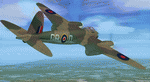
This folder contains a repaint for the DeHavilland DH98 Mosquito by Dave Garwood, in the colors of W4072 GB-D, a B Mk.IV of 105 squadron. On 25 june 1942, while being loaned to 139 squadron, it was being flown by Flt Lt Bagguley on a night attack on Stade aerodrome near Hamburg. He attacked the town of Dorum, near Bremerhaven. On leaving the target, instead of closing the bombdoors, he accidenatly lowered the flaps. These were torn away due to the speed of over 380 mph, and on arrival back at Horsham St Faith, W4072 overshot the runway, with the right undercarriage collapsing in a ditch. W4072 was delivered to 105 sqn on 27 februari 1942, and took part in the first bomb raid carried out by Mosquito's, when sqn ldr Oekeshott took it to Cologne on 31 May 1942. After the prang in june, W4072 was repaired and flew more missions with 105 sqn. Damaged again in March 1943, she passed to 627 sqn (AZ-Q), but crashed in the North Sea returning from a raid on Frankfurt on 8 january 1944. Repaint by Jan Kees Blom, based on the paintkit by Dave Garwood.
| Filename: | De_Havilland_DH98_Mosquito_W4072_105_Sqn_GBD.zip |
| License: | Freeware |
| Added: | 3rd August 2018, 23:43:28 |
| Downloads: | 146 |
| Author: | Jan Kees Blom |
| Size: | 2.77 MB |


© 2001-2026 AVSIM Online
All Rights Reserved
Privacy Policy |