
Where Flight Simulation Enthusiasts Gather from Around the World!
AVSIM Library - Search Results

| Category: Flight Simulator X - Scenery | |
| Bornholm Island X DEMO |

|
Images related to this file:
File Description:
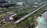
BORNHOLM ISLAND X DEMO features an extremely detailed scenery of Bornholm Island with EKRN Ronne airport in Denmark, fully compatible with both FSX and P3Dv1.
It's a fully functional DEMO version of the commercial payware product. It features same airport layout as in the full version but with limited 3D objects and low resolution textures. Using this free demo ensures no problems with online (VATSIM, IVAO, multiplayer etc.) flying in case some users use the payware scenery and some don't.
Bornholm is an island located in the Baltic Sea 37 km south of Sweden and the north of Poland. Bornholm Airport (RNN / EKRN) is a Danish airport located 2.7 nautical miles (5 km) southeast of Ronne.
This product is equipped with an automatic installer, which means that the scenery will be automatically added to the Flight Simulator Scenery Library.
Please uninstall all previous versions of this airport you may have installed before. Please make also sure that no duplicated AFCAD files are installed. Enjoy your virtual flying with Drzewiecki Design!
| Filename: | Bornholm_Island_X_DEMO.zip |
| License: | Commercial demo |
| Added: | 2nd September 2015, 21:47:52 |
| Downloads: | 1,787 |
| Author: | Drzewiecki Design |
| Size: | 15.39 MB |
| Category: Flight Simulator X - AFCAD Files | |
| LYUZ - Ponikve airport - Uzice, Serbia |
|
File Description:
Uzice Ponikve Airport (Serbian: Aerodrom Uzice Ponikve) (IATA: UZC, ICAO: LYUZ); also known as Lepa Glava (literally: Beautiful Head) is an airport in the western part of Serbia. The airport is located at Ponikve (literally: Sinkholes) plateau: 8 km (5 mi) southwest from the Jelova Gora, 11 km (7 mi) east from the Mount Tara, 12 km (7.5 mi) northwest from the city of Uzice, 13 km (8 mi) southeast from the town of Bajina Basta, 19 km (12 mi) northeast from the popular tourist center with unique attractions of the Mokra Gora, 20 km (12.5 mi) north from the Mount Zlatibor, 20 km (12.5 mi) southwest from the town of Kosjeric, 27 km (17 mi) northwest from the town of Pozega, 32 km (20 mi) southwest from the Mountain resort Divcibare, 35 km (22 mi) northeast from the town of Visegrad in Republic of Srpska (BiH), 50 km (31 mi) northwest from the Mount Zlatar. The airport is partially reconstructed in order to become an international airport. Charts included
| Filename: | LYUZ__Ponikve_airport__Uzice_Serbia.zip |
| License: | Freeware |
| Added: | 18th August 2016, 03:56:56 |
| Downloads: | 245 |
| Author: | Danilo Jankovic |
| Size: | 3.56 MB |
| Category: Flight Simulator 2004 - Scenery | |
| Alaska South Slope 8; Shishmaref PASH |
|
Images related to this file:
File Description:
There are four main northwestern Alaska towns which are serviced by Alaska Airlines, and from which local flights spread out. The northernmost is Barrow. Southwest of Barrow is Kotzebue, then Nome, and the furthest south is Bethel (not yet made). This is the first in a series for flights from Nome, and it is Shishmaref, 125 miles north of Nome on the far side of the Seward Peninsula.
Shishmaref is a village on one of a string of islands off the northern shore of the Seward Peninsula, with a population of around 560. Like other similarly-sited villages (Kivalina, for instance) it is feeling the effects of coastal erosion and there are plans for a relocation, eventually. The airfield is just beside the village, with a runway of just under 5,000 feet of lit asphalt aligned 05-23, with PAPI on both ends. There are scheduled flights by Era (now renamed Ravn) and by Bering Air, both of them originating in Nome. The AI includes these flights along with Everts Air and GA.
| Filename: | Alaska_South_Slope_8_Shishmaref_PASH.zip |
| License: | Freeware, limited distribution |
| Added: | 20th October 2016, 04:37:02 |
| Downloads: | 213 |
| Author: | Roger Wensley |
| Size: | 2.32 MB |
| Category: Prepar3D V1-4 - Scenery | |
| Valdez Alaska USA N61.06.53 W146.19.52 and Tatitlek Alaska USA N6052.00 W146.41.37 |
|
File Description:
Valdez Alaska USA N61.06.53 W146.19.52 The town is positioned at the head of a fjord on the eastern side of the Prince William Strait (at the end of the Valdez bay). It is surrounded by the Chugach mountains with many glaciers and peaks up to 2100 m above sea level. Although the northernmost port in North America is free of ice all year round. It is also the northernmost point of the Pacific coastal forest located in the 107-meter hill southwest of the town called Blueberry Hill. Valdez has an ICAO PAVD airport that in the scenario in addition to the city of Valdez you will also find a small village called Tatitlek Alaska USA N6052.00 W146.41.37 with related ICAO 7KA airport airports infrastructures have been improved with the addition of a port for landing ships and seaplanes on Valdez and Tatitlek. Important VFR point for approaching airport and seairport PAVD and 7KA.
Within the downloaded package you will find readme files for scenery installation. Good fly VFR. Pasquale Marrulli.
| Filename: | Valdez_Alaska_USA_N610653_W1461952_and_Tatitlek_Al.zip |
| License: | Freeware |
| Added: | 21st May 2018, 22:35:56 |
| Downloads: | 230 |
| Author: | Pasquale Marrulli |
| Size: | 3.27 MB |
| Category: Prepar3D V1-4 - Aircraft Repaints, Textures and Modifications | |
| Douglas C-47 French Navy (36) |
|
Images related to this file:
File Description:
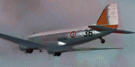
This folder contains a repaint for P3Dv4.5 PBR version of the Douglas C-47 by Manfred Jahn and colleagues in the colors of C-47 #36 of the French Navy (Aeronavale). Originally c/n9798 42-23936 it flew with the USAAF in North Africa and later in the ETO. It took part in D-Day, Market Garden and Operation Varsity, dropping parachutists. After WW2 it went to Ceskoslovenske Aeroline as OK-WDU and between 1958 and 1983 with the French navy as #36. It later went to Stellair and Transvalair in France as F-GEOM, before going to the UK as G-OFON with Classic Airways and later Air Atlantique. After a stint with South Coast Airways, it went to the Aviodrome in the Netherlands in 2006, where unfortunately it was left outside without protection. When the Aviodrome went bankrupt it went to Classic Wings, who are currently restoring it for static display in the Museum in Overloon. Repaint by Jan Kees Blom for Manfred Jahn's C-47 for P3Dv4.5, with PBR, Rivet and bump detail by Ted (Tufun) Wolfgang."
| Filename: | Douglas_C47_French_Navy_36.zip |
| License: | Freeware |
| Added: | 29th January 2020, 01:04:47 |
| Downloads: | 323 |
| Author: | Jan Kees Blom |
| Size: | 42.29 MB |
| Category: Flight Simulator 2004 - Scenery | |
| CYYH - Taloyoak - Nunavut, Canada |
|
Images related to this file:
File Description:
Taloyoak is on the coast of northern mainland Canada, on the west of the Boothia Peninsula, where it is at it's narrowest. Gjoa Haven is 80 miles southwest, and Hall Beach is 300 miles to the east. Taloyoak was established around a Hudson Bay trading post that was relocated from Fort Ross in 1948 because of poor ice conditions. There is now a clinic, school, church, recreation centre, two markets, two small hotels, and housing for the population of around 900. The airfield is to the west of the village on higher ground at 92 feet asl, and the 4,020 feet of 100 feet wide gravel runway is aligned 151T/331T where T stands for "true" as opposed to magnetic in the Northern Domestic Airspace. Only JETA-1 is available, unless there is some 100LL in drums. There are flights by First Air and Canadian North and the AI includes a daily flight of each, plus an afternoon cargo visit by a Buffalo C46; the closest large city is Yellowknife, 750 miles southwest.
| Filename: | CYYH__Taloyoak__Nunavut_Canada.zip |
| License: | Freeware, limited distribution |
| Added: | 18th November 2012, 09:23:20 |
| Downloads: | 377 |
| Author: | Roger Wensley |
| Size: | 3 MB |
| Category: Flight Simulator 2004 - Scenery | |
| Cape Dorset CYTE, Baffin Island, Nunavut, Canada |
|
Images related to this file:
File Description:
Cape Dorset is a village of 1,300 or so inhabitants at N 64 13 W 76 31 on Dorset Island, off the southwest corner of Baffin Island. It's Inuit name is Kinngait, which means "High Mountains"; watch out if you fly there in low clouds. The village (again) does not feature in FS9 but is included in this scenery with approximately the right shape, or shapes as there are separate parts. The airfield runway is just under 4,000 feet of gravel 100 feet wide at 158 feet above sea level. There is a double gradient to it, but unfortunately this cannot be replicated in FS.
Cape Dorset had a Hudson Bay Company store as long ago as 1913, and is now known as a centre for Inuit art. I added the roads, a new airfield background, a pond between apron and runway, plus of course there is the scenery file and the AFCAD and AI, which has two planes visiting, a First Air HS748 and a Canadian North Dash 8-100, as per real life.
| Filename: | Cape_Dorset_CYTE_Baffin_Island_Nunavut_Canada.zip |
| License: | Freeware, limited distribution |
| Added: | 9th December 2010, 18:45:06 |
| Downloads: | 1,015 |
| Author: | Roger Wensley |
| Size: | 2.75 MB |
| Category: Flight Simulator 2004 - Scenery | |
| Baker Lake CYBK in Nunavut, Canada |
|
Images related to this file:
File Description:
Baker Lake is the only Nunavut community that is not next to the sea. It is, as you might have guessed, on the shore of Baker Lake and 160 miles west and a bit north of Rankin Inlet on the shore of Hudson Bay (a recent post by Sid and Pete). The Hudson Bay Company opened a trading post there in 1916 and the town slowly developed, though as recently as 1946 the population was still only 32. These days the airfield is the support field for several nearby mines and there are now nearly 1,800 folks in Baker Lake using the stores, schools, churches, hospital, etc. The runway is almost 4,200' of 100' wide gravel and lighted; the alignment is 162T and 342T as this is in northern domestic airspace and bearings are given as 'true" and not "magnetic". Both JETA and 100LL fuel is available. The town is to the northeast of the airfield and is made up of a landclass without autogeneration, as this would mean a bunch of trees that would be, to say the least, unrealistic.
| Filename: | Baker_Lake_CYBK_in_Nunavut_Canada.zip |
| License: | Freeware, limited distribution |
| Added: | 23rd November 2011, 09:21:56 |
| Downloads: | 516 |
| Author: | Roger Wensley |
| Size: | 2.45 MB |
| Category: Flight Simulator 2004 - Aircraft Repaints, Textures and Modifications | |
| Luxair Boeing 737-800 |
|
Images related to this file:
File Description:

El Boeing 737-800 de Luxair (Luxair Societe Luxembourgeoise de Navigation Aerienne S.A.) (IATA: LG, OACI: LGL), es la aerolinea nacional de Luxemburgo. Es la sucesora de Luxembourg Airlines Company, el cual habia sido fundada en 1948, Luxair fue creada en 1961 para cumplir con los requerimientos de una creciente demanda para conexiones aereas entre Luxemburgo y otras capitales europeas. Su base de operaciones se encuentra en el Aeropuerto de Luxemburgo, El modelo fue hecho por el grupo Project Open Sky, incluye el modelo y las texturas, visiten mi blog en http://aerosimulaciones.blogspot.com/
The Luxair Boeing 737-800, Luxair S.A., Societe Luxembourgeoise de Navigation Aerienne, operating as Luxair, is the flag carrier airline of the Grand Duchy of Luxembourg. It operates scheduled services to 50 destinations in Europe, North Africa, the Mediterranean and Middle East, plus charter and seasonal summer services. Its head office is located on the grounds of Luxembourg - Findel Airport in Sandweiler. Its main base is Luxembourg - Findel Airport, The model was made by Project Open Sky, model and textures are included, visit my blog in http://aerosimulaciones.blogspot.com/
| Filename: | Luxair_Boeing_737800.zip |
| License: | Freeware |
| Added: | 14th September 2011, 00:48:25 |
| Downloads: | 524 |
| Author: | Juan Rodriguez / AeroSimulaciones |
| Size: | 8.2 MB |
| Category: Flight Simulator X - Scenery | |
| South China Sea Bases |
|
File Description:
This file contains five man-made bases with helipads which have been created in recent times by China, AND one man-made island airport with a large runway in the same area. The South China Sea is an area with disputed claims, with no natural land the UN has made several rulings. Many nations conduct what is called 'Right of Navigation' covered by the UNCLOS Part VII, which allows freedom of overflight and navigation. Also included is the Fuluo North East AB on Hainan Island. Note these are simple basic sceneries to allow flying around the area in FSX. There was nothing in FSX, and many dont have ICAO IDs assigned. These are not payware quality, however they were created with ADE. Thanks goes to them.
Included are
++ AG882 - Fuluo NE AB - large Air base
++ ZCUA - Huayang Jiao (Cuarteron Reef) Helipad
++ ZGAV - Nanxun Jiao (Gaven Reef) Helipad
++ ZHUG - Dongmen Jiao (Hughes Reef) Helipad
++ ZJOH - Chigua Jiao (Johnson South Reef) Helipad
++ ZMIS - Meiji Jiao (Mischief Reef) Large Airport
++ ZSC2 - Sin Cowe Island - Helipad
| Filename: | South_China_Sea_Bases.zip |
| License: | Freeware |
| Added: | 5th August 2017, 22:54:53 |
| Downloads: | 463 |
| Author: | Sean Harrison |
| Size: | 280.77 KB |


© 2001-2026 AVSIM Online
All Rights Reserved
Privacy Policy |