
Where Flight Simulation Enthusiasts Gather from Around the World!
AVSIM Library - Search Results

| Category: Flight Simulator X - Aircraft Repaints, Textures and Modifications | |
| Piper PA-23 Aztec F (C-FGCC) |

|
Images related to this file:
File Description:
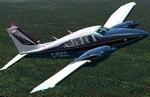
This is a repaint for our friends to the North that feel they don't get enough Canadian registered aircraft in the first wave. I have taken the excellent dark blue default livery from the Alabeo Aztec offering and rebranded it as C-FGCC. Nothing more, nothing less. I did make a new thumbnail and compiled the text for updating your aircraft.cfg file. This is the Poster Child photo repaint of the mid 70s for the 6-seat, heavy hauler, Piper Aztec PA23-250. This one has factory Lycoming turbos so it will climb high and go a little faster. Not fast, by any measure, but faster and get better gas mileage and have a better view from up high. You can also add your F1 GTN750 to the VC panel should you own one. Nice. Of course, you must have your own payware Alabeo PA23_Aztec_F_250 installed in FSX/FSX:SE/P3Dv2-v3.
| Filename: | Piper_PA23_Aztec_F_CFGCC.zip |
| License: | Freeware |
| Added: | 26th February 2016, 10:10:43 |
| Downloads: | 503 |
| Author: | Ray Marshall |
| Size: | 28.31 MB |
| Category: Flight Simulator X - Scenery | |
| Corpus Christi Intl Aiport, TX (KCRP) |
|
Images related to this file:
File Description:
Corpus Christi, Texas, located on the Gulf of Mexico is a major aviation center with Naval Aviation headquartered here and home to an Army major depot that supports all tri-service rotor wing aircraft. While these activities are based in and around the town there is significant transient military traffic at KCRP along side commercial carrier service by AAL, SWA and UAL to KDFW, KHOU and KIAH. The airport has just completed a major upgrade to both runways (renumbered from default FSX/P3D scenery) and all taxi surfaces. This scenery was constructed with ADEv1.70 targeted for P3D; however, it works as well in FSX. All runway and ILS data has been 'as-built' in accordance with FAA NASD data with extensive use of hand-placed ground polys for taxi markings. I have omitted surrounding landclass modifications for a best fit with Orbx FTX Global OpenLC North America product.
| Filename: | Corpus_Christi_Intl_Aiport_TX_KCRP.zip |
| License: | Freeware |
| Added: | 31st October 2016, 00:39:10 |
| Downloads: | 1,523 |
| Author: | Dan Downs |
| Size: | 674.06 KB |
| Category: Flight Simulator X - Scenery | |
| Clark International Airport RPLC - CRK |
|
Images related to this file:
File Description:

FSX scenery for Clark International Airport in Angeles city, Papamga Province , Philippines.
Clark International Airport, formerly the Diosdado Macapagal International Airport (IATA: CRK, ICAO: RPLC), is an airport that is an international gateway to the Philippines within Clark Freeport Zone located 80KM northwest of Manila. The airport is located along the border between the cities of Angeles and Mabalacat in the province of Pampanga and is accessible through the Subic-Clark-Tarlac Expressway, which is connected to the North Luzon Expressway.
Clark serves the general vicinity of central and northern Luzon. The name is derived from the former American Clark Air Force Base which was the largest overseas base of the United States Air Force until it was closed in 1991 and handed over to the Government of the Philippines.
Airlines serving CRK include Air Asia, Asiana, Cebu Pacific, Dragonair, Emirates, Jin Air, Qatar Airways, Tigerair, Fedex and Ups
| Filename: | Clark_International_Airport_RPLC__CRK.zip |
| License: | Freeware, limited distribution |
| Added: | 24th September 2016, 02:43:49 |
| Downloads: | 3,063 |
| Author: | Yann Martineau |
| Size: | 515.94 KB |
| Category: Flight Simulator X - Scenery | |
| Ghat HLGT Libya |
|
Images related to this file:
File Description:
Ghat is a medium-sized airport located in the south-west of Libya, near Algerian border, and 10 miles north of the city of Ghat. In early 2010s Ghat was undergoing major renovatios, but civil war in Libya has put these plans on hold. While all runways and taxiways were recently repaved, new passenger terminal is still unfinished, and air traffic is almost non-existent. Except from military and cargo planes, the only regular passenger flight to Ghat nowadays is Air Libyan from Tripoli: their A320 is visiting this place twice a week. This scenery has super-accurate layout, precise marking, and correct navaids according to the latest satellite images and charts. Photo background blends perfectly with ORBX Global. Unfinished new terminal with the construction site. Taxi signs were added for convenience. Enhanced city of Ghat and surrounding landclass. Made for P3Dv3, tested on P3Dv4 and FSX:SE. Made by Dmitriy Kozyrev.
| Filename: | Ghat_HLGT_Libya.zip |
| License: | Freeware |
| Added: | 27th September 2017, 06:18:00 |
| Downloads: | 1,223 |
| Author: | Dmitriy Kozyrev |
| Size: | 31.43 MB |
| Category: X-Plane - Scenery | |
| BR AP SBAM - Amapa Airport v1.0.0 |
|
Images related to this file:
File Description:
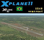
This is an X-Plane 11 and X-Plane 10 scenery package for Amapá Airport (ICAO: SBAM, no IATA code), which is the airport servining the city of Amapá, state Amapá, in Brazil.
It includes corrected aprons, ramps, gates, taxiways, lighting system, ortho-photoscenery for the airfield area, and (XP11 only) airport ground services (like push back).
This is a general aviation airport in the north of the Amazon Rainforest, close to the Brazilian-Frenchg Guyana border. It belongs to the municipality of Amapá, and it is at a distance of 8 km from the city center and 229 km from the state capital, Macapá.
This scenery was tested and is operational (as of January 20, 2018) in "X-Plane 11.11 64 bit", Windows 10 Home. It was also tested and is also operational (as of January 20, 2018) in "X-Plane 10.51 64 bit", Windows 10 Home.
| Filename: | BR_AP_SBAM__Amapa_Airport_v100.zip |
| License: | Freeware |
| Added: | 2nd February 2018, 00:18:13 |
| Downloads: | 56 |
| Author: | Rui Mesquita |
| Size: | 6.55 MB |
| Category: Flight Simulator 2004 - Scenery | |
| Kasba Lake CJL8 Northwest Territories Canada |
|
Images related to this file:
File Description:
This is a sixth airfield with links to Lake Athabasca, which is in Alberta and Saskatchewan. Kasba Lake is some 135 miles northeast of Stony Rapids and is in the Northwest Territories. The airfield is owned and run by and for Kasba Lake Lodge and it is one of several fishing vacation spots that are serviced by flights from Stony Rapids. It is these flights to the north that explain the number of regular scheduled flights into Stony Rapids from the south. The Kasba Lake Lodge has docks for boats and also for clients that want to arrive in their own floatplanes. The ai is for both Kasba Lake and Obre Lake and replaces the porpoising plane that I had used for Obre Lake. Norilor flies the weekend package-deal-long-distance delivery flights for Kasba Lake direct from Winnipeg, and now also for Obre Lake.
| Filename: | Kasba_Lake_CJL8_Northwest_Territories_Canada.zip |
| License: | Freeware, limited distribution |
| Added: | 9th August 2018, 14:21:17 |
| Downloads: | 149 |
| Author: | Roger Wensley |
| Size: | 2.48 MB |
| Category: Flight Simulator 2004 - Scenery | |
| Fort Graham CBW3 in British Columbia Canada |
|
Images related to this file:
File Description:
Fort Graham is what looks like a very small village on the eastern shore of Williston Lake in northern British Columbia, around 100 miles north of Mackenzie (a previous post). The lake, while not large by Canadian standards, is well over 100 miles long but squeezed in width to a maximum of 5 miles amid the surrounding Rockies. The airfield has a gravel runway of 5,000 feet aligned 13-31 and at 2,230 feet ASL. There is no lighting. The operator of the airfield (and presumably the "village" too) is Finlay River Outfitters, a company that is based in Mackenzie and "outfits" hunting trips in the local area. I have posted this as Fort Graham CBW3, but I suggest that you just add it to your previously created "BC airfields" and avoid the inevitable doubling up of common textures etc. Up to you. If you find a defect, email me.
| Filename: | Fort_Graham_CBW3_in_British_Columbia_Canada.zip |
| License: | Freeware, limited distribution |
| Added: | 23rd November 2020, 20:13:11 |
| Downloads: | 108 |
| Author: | Roger Wensley |
| Size: | 7.75 MB |
| Category: Flight Simulator 2004 - Scenery | |
| Churchill Falls CZUM in Newfoundland and Labrador Canada |
|
Images related to this file:
File Description:
Churchill Falls is a small town on the Churchill River, around 230 miles north of the Gulf of St Lawrence coast and 120 miles east of Labrador City. It is a company-built town for the staff and families that work in the generating station associated with the falls. The falls were first discovered in the 1830's and work on the generating station commenced in 1967. The runway is 5,500 feet of asphalt aligned 13-31, with PAPI and approach lighting at both ends, and the apron at the eastern end. The buildings are well replicated here and the AI includes both GA flights and the daily flights by Provincial Airways, along with a medical transport service. There is a dock for float planes on a nearby lake that is no longer in regular use and officially listed as closed, but the dock remains there and is included here.
| Filename: | Churchill_Falls_CZUM_in_Newfoundland_and_Labrador_.zip |
| License: | Freeware, limited distribution |
| Added: | 25th August 2020, 18:16:40 |
| Downloads: | 180 |
| Author: | Roger Wensley |
| Size: | 11.92 MB |
| Category: Prepar3D V1-4 - Scenery | |
| Square Kilometre Array (MeerKAT) – South Africa |
|
Images related to this file:
File Description:

This scenery is of the MeerKAT radio telescope site (originally the Karoo Array Telescope – KAT but was changed to MeerKAT, meer=more) when the project was expanded to 64 dishes. It forms part of an international Square Kilometre Array (SKA) project. It is situated in the Karoo near the town of Carnarvon. The scenery includes the landing strip just North East of the biggest concentration of dishes. I could not find a code for this strip and called it FAKA (MeerKAT SKA), or take off from Carnarvon (FACN) and fly a heading of 320 degrees for 73 km. The scenery was designed and tested for P3D V5 to work with the ORBX Africa LC and Pilots NG2020 mesh products. I am not sure what the actual site would look like at night, but I included some night lighting to make the array visible after dark.
| Filename: | Square_Kilometre_Array_MeerKAT__South_Africa.zip |
| License: | Freeware |
| Added: | 14th August 2020, 22:53:38 |
| Downloads: | 99 |
| Author: | Johan Pienaar |
| Size: | 20.33 MB |
| Category: Flight Simulator 2004 - Scenery | |
| LFJA Chaumont_Semoutiers AB |
|
Images related to this file:
File Description:
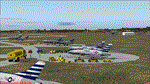
From 1950 to 1967 the USAF set up and maintained bases in France, with the agreement of the French government, as part of its commitment to the North Atlantic Treaty Organisation. Chaumont AB was one of the ten main air bases which supported both attack and air defence capabilities. Many people do not appreciate the sheer extent of the USAF bases in France at this time and the reasons leading to the USAF departure in 1967. There is a link to a fine article on all this included.
This scenery and traffic represent Chaoumont Air Base during the years 1955 to 1962. Custom Tower and Hangars by Dan French along with a large number of custom paints by DeltataDart for the many types of aircraft represented over this period. Traffic files and the aircraft and paints needed are provided for 1955 (including the Skyblazer Demonstration Team), 1957, 1959 and 1962.
| Filename: | LFJA_Chaumont_Semoutiers_AB.zip |
| License: | Freeware |
| Added: | 22nd November 2023, 16:08:16 |
| Downloads: | 109 |
| Author: | Al von Pingel, Ken Lawson, Dan French, DeltaDart |
| Size: | 38.9 MB |


© 2001-2026 AVSIM Online
All Rights Reserved
Privacy Policy |