
Where Flight Simulation Enthusiasts Gather from Around the World!
AVSIM Library - Search Results

| Category: Flight Simulator 2004 - Scenery | |
| Warnervale, NSW, Australia |

|
File Description:
This version is a major update of this fine little airport
with the permission of Greg Archer, the original author.
Upgrades include the Terminal building, Booking office,
some hangars, lights and trees all featuring photo real textures.
An AFCAD file and AI traffic are now included.
Warnervale NSW, is a small airfield not included in FS2002 or 2004.
It is however a busy little field run by the Central Coast Aero Club
and incorporates the Drop Zone Skydiving Centre, as well as
Joy Flights over the Beautiful Central Coast of NSW.
The field is very close to Aeropelican Airport home of
Aeropelican Airways which has regular services to
Sydney Kingsford Smith International using Twin Otters.
in fact you can see Aeropelican Airstrip 8NM to the
north once you take off from Warnervale.
You can download Aeropelican from this site (aero2004.zip).
Both airfields complement each other, just follow the sail boats north.
Textures required. Airport 2.6, VOD, Nova and Nova Gold.
| Filename: | Warnervale_NSW_Australia.zip |
| License: | Freeware |
| Added: | 4th June 2004, 14:04:15 |
| Downloads: | 1,770 |
| Author: | Clive Marriott |
| Size: | 1.9 MB |
| Category: Flight Simulator 2004 - Scenery | |
| Paul Farm Field CF16 in Ontario, Canada |
|
Images related to this file:
File Description:
Paul Field is on the south side of Highway 174, four miles east of Hawkesbury Windover Field and five miles west of the town of Hawkesbury; the town is on the south bank of the Ottawa River approximately midway between Ottawa and Montreal. I first saw the field when I was on the way to Windover a few years ago. I asked some old timers at Windover who the grass strip belonged to and they said "Paul". It may not be what Paul calls it, but it's the only name I know it by. Probably Paul doesn't call it anything, it's just the field where he keeps his plane. There is a grass runway approximately north-south and 2,000 feet long, and two hangars which look to be an old one and a new one. In real life the runway isn't so north-south as it lines up with the farm fields alignment which is of course in FS is auto-generated and not actuality-accurate.
| Filename: | Paul_Farm_Field_CF16_in_Ontario_Canada.zip |
| License: | Freeware, limited distribution |
| Added: | 6th February 2010, 02:36:49 |
| Downloads: | 291 |
| Author: | Roger Wensley |
| Size: | 997.17 KB |
| Category: Prepar3D V1-4 - Scenery | |
| TNCC - - Curaçao International Airport V 2.0 |
|
File Description:
This is an improved version of my previous senario for TNCC. This version has substantial improvements in the terminals and areas of the airport.
Curaçao International Airport (IATA: CUR, ICAO: TNCC), (Dutch: Hato Internationale luchthaven) also known as Hato International Airport (formerly Dr. Albert Plesman International Airport), is the only airport for the island of Curaçao.
The airport is located on the north coast of Curaçao, 12 kilometres (7.5 mi) from the capital Willemstad. Curaçao International Airport services flights from the Caribbean region, South America, North America and Europe and has the third longest commercial runway in the Caribbean region after Rafael Hernández Airport in Puerto Rico and Pointe-à -Pitre International Airport in Guadeloupe.
The airport serves as a main base for Divi Divi Air, Jetair Caribbean as well as EZAir; it formerly served as a main base for ALM, KLM, DCA, DAE and Insel Air.
| Filename: | TNCC___Curaao_International_Airport_V_20.zip |
| License: | Freeware |
| Added: | 25th June 2021, 18:19:49 |
| Downloads: | 451 |
| Author: | Eduardo Puelker |
| Size: | 37.41 MB |
| Category: Flight Simulator X - Scenery | |
| Barbados island photo scenery |
|
File Description:
Barbados is my home island so I've decided to make a photo scenery for it. please understand that am not a professional at scenery but if anyone is willing to help me improve it, am open for it.
Barbados is a sovereign island country in the Lesser Antilles, in the Americas. It is 34 kilometres (21 miles) in length and up to 23 km (14 mi) in width,
covering an area of 432 km2 (167 sq mi). It is situated in the western area of the North Atlantic and 100 km (62 mi) east of the Windward Islands and the Caribbean Sea;[6] therein,
it is about 168 km (104 mi) east of the islands of Saint Vincent and the Grenadines and 400 km (250 mi) north-east of Trinidad and Tobago. Barbados is outside of the principal Atlantic hurricane belt.
Its capital is Bridgetown. Barbados is 1,600 mi (2,600 km) Southeast of Miami.
| Filename: | Barbados_island_photo_scenery.zip |
| License: | Freeware |
| Added: | 5th October 2016, 22:31:01 |
| Downloads: | 632 |
| Author: | Shakur Jones |
| Size: | 55.73 MB |
| Category: Flight Simulator 2004 - Scenery | |
| Yellowknife Floats CEN9 - Northwest Territories, Canada |
|
Images related to this file:
File Description:
Yellowknife float base is on the shore of Yellowknife Bay, which is on the north side of Great Slave Lake. The float base is on two sides of Latham Island and the promontory that reaches out to it, which is where the town of Yellowknife was originally founded, and float planes land either in Back Bay (to the west) or in East Bay (guess where?). Where the south end of the island meets the promontory there are two inlets and two companies; Air Tindi in the eastern part and North Airways in the western. These two companies have bespoke buildings. I have used other buildings from other sceneries to model the "feel" of the original Yellowknife and the docks along the shore. One thing I could not do, and that was to recreate at its correct height "the rock", which is the raised centre of the promontory; FS9 resisted terrain readjustments beyond a certain point.
| Filename: | Yellowknife_Floats_CEN9__Northwest_Territories_Can.zip |
| License: | Freeware, limited distribution |
| Added: | 1st February 2012, 23:53:17 |
| Downloads: | 920 |
| Author: | Roger Wensley |
| Size: | 12.38 MB |
| Category: Flight Simulator 2004 - AI Flight Plans | |
| RAF Nimrod MR2 R1 and MRA4 aircraft |
|
File Description:
This is an attempt to represent all Nimrod MR2, R1 and MRA4 aircraft. But I cannot vouch for the accuracy - all info has been researched from the web.
The flights include operations from EGQK Kinloss (MR2), EGXW Waddington (R1), EGNO Warton (MRA4), EGCD Woodford (MRA4) and the Middle East. The aircraft patrol the North Sea, North Atlantic, Irish Sea, Mediterranean and Persian Gulf. Visited airfields include LXGB Gibraltar and OOMS Muscat Seeb, where Middle East operations are conducted from. These include patrols over Iraq and Afghanistan, which I have implemented by using waypoints where "ai missed approaches" will occur. Missed approach training is also conducted at many Scottish and northern English airfields (as per the evidence from Airliners.net). Other overseas exercises include a Nimrod or two visiting Australia for the Fincastle trophy, etc. etc. Four Nimrod MRA4 from EGNO Warton and EGCD Woodford are shown undergoing flight trials.
Complements my AF2 files of EGQK and OOMS (on Avsim).
| Filename: | RAF_Nimrod_MR2_R1_and_MRA4_aircraft.zip |
| License: | Freeware |
| Added: | 11th April 2009, 19:53:55 |
| Downloads: | 1,412 |
| Author: | Dan Foster |
| Size: | 14.26 KB |
| Category: Flight Simulator 2004 - AFCAD Files | |
| Ugnu-Kuparuk (UBW / PAKU), Kuparuk, Alaska |
|
File Description:
This is an improved and realistic AFCAD2 file for Ugnu-Kuparuk - a private airstrip on the North Slope, Alaska. With this AFCAD Kuparuk is now able to handle AI traffic also. ConocoPhilips is flying workers for the oil industry to this airfield and Deadhorse (SCC/PASC) from Anchorage several times a week with two leased Boeing 737-200 aircraft. Updated flight plans for ConocoPhilips will be released shortly.
| Filename: | UgnuKuparuk_UBW__PAKU_Kuparuk_Alaska.zip |
| License: | Freeware, limited distribution |
| Added: | 22nd January 2007, 16:59:39 |
| Downloads: | 478 |
| Author: | Rene Tanggaard |
| Size: | 27.9 KB |
| Category: Flight Simulator 2004 - AFCAD Files | |
| KATL |
|
File Description:
This AFCAD2 File adds just about all the gates on Terminals A,B,C,D and E. adds parking spaces at the Delta JetBase, North Cargo Terminal, South Cargo Terminal, GA and Private Aviation.
Fixes all runway errors including: Lighting, Markings, length, overrun zones and PAPI setups.
Fixes all Taxiway/Ramp errors including: Markings, Lines, Lighting, designations, locations and also includes Apron Lighting where it is used on the Real KATL.
| Filename: | KATL.zip |
| License: | Freeware |
| Added: | 2nd July 2004, 03:59:13 |
| Downloads: | 1,207 |
| Author: | Andrew Mycoskie |
| Size: | 96.3 KB |
| Category: Flight Simulator 2004 - AI Flight Plans | |
| Nok Air - Winter 2005 |
|
File Description:
Nok Air is probably the most colourful low cost airline going and was started just last year by Thai Airways to serve the Thai people and tourists with a low cost - high quality service better than any other in Thailand. Based in Bangkok, Nok (Thai for bird) Air covers the whole country with a select number of destinations from Chiang Mai in the North to Phuket in the South.
| Filename: | Nok_Air__Winter_2005.zip |
| License: | Freeware, limited distribution |
| Added: | 6th December 2005, 21:21:58 |
| Downloads: | 1,051 |
| Author: | Ben Clark |
| Size: | 6.24 KB |
| Category: Prepar3D V1-4 - Aircraft Repaints, Textures and Modifications | |
| Heinkel He-111 RAF (HS-?) 260 Sqn |
|
Images related to this file:
File Description:
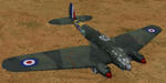
This folder contains a repaint for the Heinkel He-111 P2 by Aeroplane Heaven, in the colors of He 111-H6 HS-? as used by RAF No.260 Squadron in North Africa, december 1942. They found the abandoned aircraft Castel Beneto airfield near Tripoli, made it airworthy again and used it as a hack aircraft for squadron personnel. Repaint by Jan Kees Blom, based on the paintkit by Aeroplane Heaven.
| Filename: | Heinkel_He111_RAF_HS_260_Sqn.zip |
| License: | Freeware |
| Added: | 9th November 2019, 21:48:00 |
| Downloads: | 85 |
| Author: | Jan Kees Blom |
| Size: | 84.27 MB |


© 2001-2026 AVSIM Online
All Rights Reserved
Privacy Policy |