
Where Flight Simulation Enthusiasts Gather from Around the World!
AVSIM Library - Search Results

| Category: Flight Simulator 2004 - Scenery | |
| Wunstorf AB - Germany |

|
Images related to this file:
File Description:
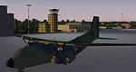
Wunstorf Air Base was originally opened in 1936 for the National Socialist Luftwaffe. Like most German airfields it did arduous duty during the Second World War. When the allies finally concluded their occupation the field was eventually returned to German control and hosted it's first German transport unit flying the Nord Atlas. This aircraft was replaced in 1971 with the current Transall 160 aircraft. With the recent adoption of the Airbus A400M by the Luftwaffe, Wunstorf is undergoing some significant remodeling including lengthening of runway 8-26 as well as construction of two new modern hangars and associated support buildings. This scenery is intended to be used with the great Transall 160 package by Ray Parker (available at Avsim.net as (gaf_c-160_transall.zip) but will of course accomodate any aircraft and is in itself a complete scenery package.
| Filename: | Wunstorf_AB__Germany.zip |
| License: | Freeware, limited distribution |
| Added: | 13th April 2014, 14:08:22 |
| Downloads: | 1,506 |
| Author: | John Stinstrom |
| Size: | 6.58 MB |
| Category: Flight Simulator 2004 - Scenery | |
| New Terrain Mesh of the Province of Quebec in LOD09 (1/4) |
|
File Description:
The files in this package contain terrain mesh files of the province of Quebec (N45 to N53) to be used with my Quebec enhanced sceneries for FS2004 (Scenes_du_Quebec_2k4.zip). The public data sources are the Shuttle Radar Topography Mission (SRTM-3, 90m) and the Canadian Digital Elevation Data (CDED - 0.75s/arc - 23m). (QC09_2k4a.zip to QC09_2k4d.zip - 4 parts)
***********************
Les fichiers de ces archives contiennent les donnees d'elevation de terrain (mesh files - lod09), pour FS2004, du territoire de la province de Quebec sous le 53ieme degre de latitude nord. Ils ont ete crees pour etre utilises avec mes nouvelles scenes du Quebec contenues dans Scenes_du_Quebec_2k4.zip. Les donnees sources sont du domaine public et proviennent de la Shuttle Radar Topography Mission (SRTM-3, 90m) et des donnees numerique d'elevation du Canada (DNEC - 0.75s/arc -23 m). (QC09_2k4a.zip to QC09_2k4d.zip - 4 parties)
| Filename: | New_Terrain_Mesh_of_the_Province_of_Quebec_in_LOD09_14.zip |
| License: | Freeware, limited distribution |
| Added: | 27th January 2010, 18:10:18 |
| Downloads: | 8,915 |
| Author: | Gilles Gauthier |
| Size: | 23.76 MB |
| Category: Flight Simulator 2004 - Scenery | |
| New Terrain Mesh of the Province of Quebec in LOD09 (2/4) |
|
File Description:
The files in this package contain terrain mesh files of the province of Quebec (N45 to N53) to be used with my Quebec enhanced sceneries for FS2004 (Scenes_du_Quebec_2k4.zip). The public data sources are the Shuttle Radar Topography Mission (SRTM-3, 90m) and the Canadian Digital Elevation Data (CDED - 0.75s/arc - 23m). (QC09_2k4a.zip to QC09_2k4d.zip - 4 parts)
***********************
Les fichiers de ces archives contiennent les donnees d'elevation de terrain (mesh files - lod09), pour FS2004, du territoire de la province de Quebec sous le 53ieme degre de latitude nord. Ils ont ete crees pour etre utilises avec mes nouvelles scenes du Quebec contenues dans Scenes_du_Quebec_2k4.zip. Les donnees sources sont du domaine public et proviennent de la Shuttle Radar Topography Mission (SRTM-3, 90m) et des donnees numerique d'elevation du Canada (DNEC - 0.75s/arc -23 m). (QC09_2k4a.zip to QC09_2k4d.zip - 4 parties)
| Filename: | New_Terrain_Mesh_of_the_Province_of_Quebec_in_LOD0.zip |
| License: | Freeware, limited distribution |
| Added: | 1st November 2009, 06:47:09 |
| Downloads: | 4,627 |
| Author: | Gilles Gauthier |
| Size: | 27.78 MB |
| Category: Flight Simulator 2004 - Scenery | |
| New Terrain Mesh of the Province of Quebec in LOD09 (3/4) |
|
File Description:
The files in this package contain terrain mesh files of the province of Quebec (N45 to N53) to be used with my Quebec enhanced sceneries for FS2004 (Scenes_du_Quebec_2k4.zip). The public data sources are the Shuttle Radar Topography Mission (SRTM-3, 90m) and the Canadian Digital Elevation Data (CDED - 0.75s/arc - 23m). (QC09_2k4a.zip to QC09_2k4d.zip - 4 parts)
***********************
Les fichiers de ces archives contiennent les donnees d'elevation de terrain (mesh files - lod09), pour FS2004, du territoire de la province de Quebec sous le 53ieme degre de latitude nord. Ils ont ete crees pour etre utilises avec mes nouvelles scenes du Quebec contenues dans Scenes_du_Quebec_2k4.zip. Les donnees sources sont du domaine public et proviennent de la Shuttle Radar Topography Mission (SRTM-3, 90m) et des donnees numerique d'elevation du Canada (DNEC - 0.75s/arc -23 m). (QC09_2k4a.zip to QC09_2k4d.zip - 4 parties)
| Filename: | New_Terrain_Mesh_of_the_Province_of_Quebec_in_LOD0.zip |
| License: | Freeware, limited distribution |
| Added: | 27th January 2010, 18:15:12 |
| Downloads: | 7,495 |
| Author: | Gilles Gauthier |
| Size: | 29.35 MB |
| Category: Flight Simulator 2004 - Scenery | |
| New Terrain Mesh of the Province of Quebec in LOD09 (4/4) |
|
File Description:
The files in this package contain terrain mesh files of the province of Quebec (N45 to N53) to be used with my Quebec enhanced sceneries for FS2004 (Scenes_du_Quebec_2k4.zip). The public data sources are the Shuttle Radar Topography Mission (SRTM-3, 90m) and the Canadian Digital Elevation Data (CDED - 0.75s/arc - 23m). (QC09_2k4a.zip to QC09_2k4d.zip - 4 parts)
***********************
Les fichiers de ces archives contiennent les donnees d'elevation de terrain (mesh files - lod09), pour FS2004, du territoire de la province de Quebec sous le 53ieme degre de latitude nord. Ils ont ete crees pour etre utilises avec mes nouvelles scenes du Quebec contenues dans Scenes_du_Quebec_2k4.zip. Les donnees sources sont du domaine public et proviennent de la Shuttle Radar Topography Mission (SRTM-3, 90m) et des donnees numerique d'elevation du Canada (DNEC - 0.75s/arc -23 m). (QC09_2k4a.zip to QC09_2k4d.zip - 4 parties)
| Filename: | New_Terrain_Mesh_of_the_Province_of_Quebec_in_LOD0.zip |
| License: | Freeware, limited distribution |
| Added: | 27th January 2010, 18:17:08 |
| Downloads: | 7,854 |
| Author: | Gilles Gauthier |
| Size: | 20.94 MB |
| Category: Flight Simulator X - Aircraft Repaints, Textures and Modifications | |
| FSX/P3Dv3 Alisarda F-27-200 1973 |
|
Images related to this file:
File Description:

This is a repaint of the F-27-200 in Alisarda colors. The freeware FSX Native with VC F-27-200 by Bjorn Kesten is needed for this repaint. It was converted from Mike Stone's and Tom Gibson's models. The textures are 32bit DDS. It was tested on FSX-SE, but should work on FSX & P3Dv3.
Alisarda was an Italian airline based at Olbia, in Sardinia. It was established on March 28, 1963 as an air taxi company registered under the official name Linee Aerea della Sardegna SpA. Their first aircaft were two Beech 18s and Alisarda only provided a charter service. However, one year later,in 1964, they opened their fist scheduled service from Olbia to Rome. 1965 proved to be a pivotal year for the carrier. A reorganization was carried out whereby an agreement was concluded with Algenova for technical and commercial support. New investors were found, and in February 1965 two new Nord 262s were ordered from Nord Aviation. Due to this greater transport capacity, the transport figures increased strongly and in 1966 a total of 5,640 passengers were transported. The passenger loads increased dramatically in 1968 and 1969, so, Alisarda purchased three F-27 Friendships to take up the extra loads. The airline entered the 1970s with strength, and in January 1974 they received their first pure jets with the purchase of two DC-9-14s from Delta Airlines, I-SARJ and the I-SARV. 1977 saw them purchase two DC-9-32s, followed by three DC-9-50s in 1983, which replaced the aging DC-9-14s. In 1984 they received two new Maddog 82s. Their route network by 1989 consisted of domestic flights to many cities in Italy, plus international routes to Zurich, Geneva, Munich, Frankfurt, Paris, and Nice. In 1991 Alisarda merged with the Spanish carrier Universair, as the shareholders wanted to become a bigger players on the European market. The new carrier was named Meridiana. Thus, the name Alisarda ceased to exist.
| Filename: | FSXP3Dv3_Alisarda_F27200_1973.zip |
| License: | Freeware |
| Added: | 21st January 2020, 17:49:09 |
| Downloads: | 80 |
| Author: | Ted Giana |
| Size: | 4.79 MB |
| Category: Flight Simulator 2004 - Sounds | |
| Stereo Sound Upgrade for Bristol Hercules Engines |
|
File Description:
This stereo sound upgrade of Harry
Follas's Bristol Hercules piston-engine
sounds for FS98 was created primarily
for use with the Handley Page Hermes
by Georg Hauzenberger, but should work
well with any aircraft that was fitted
with these engines. This includes
aircraft such as the Handley Page
Hastings, Grumman Albatross, Nord
Noratlas, Vickers Viking, Short Solent,
Avro Lancaster (Mk2 models) and the
Bristol Beaufighter.
By converting the sounds to FS2004
multiple-engine stereo, the engines
now emit a realistic piston-engine roar
at full throttle, but this quietens
down to a more subtle sound in cruise.
Other associated sounds have been
added - ehgine startup, shutdown and
wind effects in flight. Touchdown
effects will now detect if the
aircraft is landing on ground or
water so you can comfortably use
these sounds with amphibious aircraft.
Requires original FS98 soundpack by
Harry Follas hercsnd.zip (the files
are also distributed with the Handley
Page Hermes and Hastings models and
probably others too.
| Filename: | Stereo_Sound_Upgrade_for_Bristol__Hercules_Engines.zip |
| License: | Freeware |
| Added: | 26th August 2004, 21:46:09 |
| Downloads: | 4,888 |
| Author: | John Hinson |
| Size: | 5.37 MB |
| Category: Prepar3D V1-4 - Scenery | |
| The island of Capraia N43.3.2 E9.50.13 and City |
|
File Description:
The island of Capraia N43.3.2 E9.50.13 is located in the Corsica Channel (arm of the sea on the border between the Ligurian Sea and the Tyrrhenian Sea), and is an island of volcanic origin, the third largest in the Tuscan Archipelago. It has high and rocky coasts with no beaches (sometimes in the Cala della Mortola there is a small sandy beach [5]) and a small lake basin (called Stagnone or Laghetto [6]) in the most mountainous area, with peaks along a central chain Anticamente called Aigylion Greeks and then Capraria from the Romans, the name derives from the presence of wild goats on the island, but according to another hypothesis the toponym derives from a Mediterranean theme * karpa with the meaning of «rock». It was certainly an Etruscan landing place like the other Tyrrhenian islands in the 7th century, becoming a pirate base when it was occupied by the Romans.Important VFR point for approaching fron Nord airport Isola d'Elba.
Within the downloaded package you will find readme files for scenery installation. Good fly VFR. Pasquale Marrulli.
| Filename: | The_island_of_Capraia_N4332_E95013_and_City.zip |
| License: | Freeware |
| Added: | 2nd January 2018, 17:31:32 |
| Downloads: | 154 |
| Author: | Pasquale Marrulli |
| Size: | 2.8 KB |
© 2001-2026 AVSIM Online
All Rights Reserved
Privacy Policy |