
Where Flight Simulation Enthusiasts Gather from Around the World!
AVSIM Library - Search Results

| Category: Flight Simulator 2004 - Scenery | |
| Elk City Municipal Airport, Ok |

|
File Description:
FS2004 Scenery-Elk City Municipal Airport,Ok (KELK) serves Elk City and Beckham County and is owned by the City Of Elk City. The paved runway extends for 4402 feet. The airport provides servicing of aircraft, aircraft maintenance and hanger facilities. The facility is at an elevation of 2002 feet at a distance of about one mile from Elk City. Scenery has dynamic scenery created with Lago's FSE. Modified AFCAD file. Objects placed using EZ Scenery, Rwy12 and FSDS3. Includes flightplan for AI traffic and textures for FSDS3 segments.
| Filename: | Elk_City_Municipal_Airport_Ok.zip |
| License: | Freeware |
| Added: | 11th February 2006, 23:57:10 |
| Downloads: | 514 |
| Author: | John B. Loney, Jr. |
| Size: | 741.52 KB |
| Category: Flight Simulator X - Scenery | |
| The Raptors Roost Lodge, Reef Lake, Canada |
|
File Description:
This scenery is located East of Ketchikan up near Stewart in Canada at a lake named Reef Lake. It has a water runway but you can use the beach in a pinch. There is not much room to maneuver so it may be a good idea to start here so you will know what to expect. This is not your mothers scenery. If when Holger comes out with his scenery for this area and there are conflicts I will repair it to work with that. This scenery has sounds.
| Filename: | The_Raptors_Roost_Lodge_Reef_Lake_Canada.zip |
| License: | Freeware, limited distribution |
| Added: | 7th July 2008, 13:08:30 |
| Downloads: | 1,193 |
| Author: | Joe Watson / Raptor X Sceneries |
| Size: | 1.33 MB |
| Category: Flight Simulator X - Scenery | |
| Alice Springs Photoreal |
|
File Description:
Alice Springs Photoreal Scenery - FSX ONLY.
Photoreal Scenery covering Alice Springs Airport and the Alice Springs Township areas to the North. This Scenery does not have any Autogen added but you are welcome to make some and upload it for many others to enjoy.
UNKNOWN AIRFIELD - Fly to S 23:41.72 - E 133:56.63 and you will find an unknown Airfield.
This is freeware scenery and you can upload it to any website but please never try and make money from it.
| Filename: | Alice_Springs_Photoreal.zip |
| License: | Freeware |
| Added: | 15th November 2009, 12:23:20 |
| Downloads: | 3,392 |
| Author: | David Sheridan |
| Size: | 99.78 MB |
| Category: Flight Simulator X - AFCAD Files | |
| Jugtown Mountain Airport (2NJ1), NJ |
|
File Description:
Located near Pattenburg, New Jersey, Jugtown Mountain Airport is a private turf strip. No transient services are offered. Trees are summertime ONLY.
Scenery constructed with use of satellite images/streetview, the author has not been there in person.
This scenery is meant to be used in conjunction with MegaScenery Earth New York 007. It is not required, but apron use is minimized to allow satellite scenery to show through as much as possible, and objects are placed based on the MSE textures - lack of it may make scenery look out of place.
| Filename: | Jugtown_Mountain_Airport_2NJ1_NJ.zip |
| License: | Freeware |
| Added: | 24th October 2010, 20:11:26 |
| Downloads: | 204 |
| Author: | Drew Sikora |
| Size: | 470.3 KB |
| Category: Flight Simulator X - Scenery | |
| Vancouver Medical Center.zip |
|
Images related to this file:
File Description:
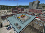
This scenery is fictional of Vancouver Medical Center. The added medical complex has 2 landable helipads. One is part of the "hospital" object and one is additional on another building at the complex. Both are landable. The complex is just south of the downtown area. Future FSX missions will utilize both these sceneries. Read the txt file for two install options. Can be installed stand-alone or by placing the bgl of this scenery into the scenery folder of "Vancouver Extras" if you downloaded that scenery. Designed to enhance your FSX world. savageagle, Enjoy!
| Filename: | Vancouver_Medical_Centerzip.zip |
| License: | Freeware |
| Added: | 19th July 2010, 00:26:07 |
| Downloads: | 537 |
| Author: | Tim Durham |
| Size: | 782.48 KB |
| Category: Flight Simulator X - Scenery | |
| 7FL6 Spruce Creek Fly-in Community |
|
Images related to this file:
File Description:

Touted as the worlds most famous residential airpark, this airfield resides within the Daytona Beach International Airport (KDAB) controlled airspace. More information is available at www.7fl6.com. The scenery includes photo landclass changes, rework of the runway, taxiways, aprons and parking; custom scenery objects and placement of library objects. Scenery in this package is based on Virtual Earth (Bing) and Google Earth imagery and photos taken locally. The package includes airport arrival-departure procedures (PDF) published by the Fly-in and scenery associated with the VFR "Tank Departure".
| Filename: | 7FL6_Spruce_Creek_Flyin_Community.zip |
| License: | Freeware |
| Added: | 13th July 2012, 05:40:50 |
| Downloads: | 1,033 |
| Author: | Art Poole |
| Size: | 5.13 MB |
| Category: Flight Simulator 2004 - Scenery | |
| Eastern West Virginia Regional Airport |
|
Images related to this file:
File Description:
Scenery for Shephard Field Virginia, home to both the Eastern West Virginia Regional Airport and the 167th Airlift Wing of the Air National Guard. Package contains custom objects and scenery for the airport which supports parking for both Civil and Military aircraft. This scenery is designed to be fully compatible with, and indeed intended, for use with the Military AI Works' 'AMC East C-5' AI package. Although the scenery is fully functional as a stand-alone package you will find some recommended downloads in the instructions that will enhance the overal effect.
| Filename: | Eastern_West_Virginia_Regional_Airport.zip |
| License: | Freeware, limited distribution |
| Added: | 31st May 2012, 23:39:14 |
| Downloads: | 1,307 |
| Author: | John Stinstrom |
| Size: | 2.7 MB |
| Category: Flight Simulator X - AFCAD Files | |
| Robert J. Miller Air Park Airport (KMJX), NJ |
|
File Description:
Located 05 miles SW of Toms River, New Jersey on 232 acres of land, R.J. Miller Air Park is a public asphalt strip 5949' in length. The airport buildings and immediate surrounding area have been included, magnetic variation adjusted, PAPI properly placed, taxiway lines drawn accurately, beacon properly placed, lit winsock and wind tee (both functional). The parking available has been matched to the current configuration of the airport, which is still undergoing renovation. Not included is the under-construction building just to the south of the terminal and the additional large hangar just north of the already-existing one. Taxiway lighting could not be seen in aerial photos - complete liberty on behalf of the author was taken when placing taxiway lights. Helipad is lit at night although the real world pad is not. Tiedown parking is available on the main tarmac in three sections: Southwest, Northeast, and regular Parking which is in the middle. RAMP_GA_SMALL parking spots are for aircraft with wingspans no greater than 40 feet. RAMP_GA_MEDIUM parking spots are for aircraft with wingspans no greater than 60 feet. RAMP_GA parking spots are occupied/blocked by static objects and should not be chosen as a start location (although collision detection with all such objects has been disabled). There are 4 open hangars - three to the Southwest are for RAMP_GA_SMALL aircraft while the Northeast one is for RAMP_GA_MEDIUM aircraft or smaller. All hangar parking spots are labeled DOCK_GA. A hangar on the main tarmac and a hangar on the tarmac to the south and west removed from the airport have attendants that can be called on NAV2 - this appears to be FS9 only. Both hangars have undecorated interiors and no parking spots to start from. There is only one helipad to start on but helicopters can also start in any RAMP_GA_MEDIUM location with no problem. Fuel for aircraft/helicopters is available by stopping next to the fuel pumps (not the fuel tank) at the north end of the main tarmac. The helipad will supply fuel when landed on.
Scenery constructed with use of satellite images/streetview/aerial photos - the author has not been there in person.
This scenery is meant to be used in conjunction with MegaScenery Earth New Jersey/Delaware 002. It is not required, but apron use is minimized to allow satellite scenery to show through as much as possible, and objects are placed based on the MSE textures - lack of it may make scenery look out of place.
| Filename: | Robert_J_Miller_Air_Park_Airport_KMJX_NJ.zip |
| License: | Freeware |
| Added: | 4th August 2011, 21:45:08 |
| Downloads: | 372 |
| Author: | Drew Sikora |
| Size: | 2.22 MB |
| Category: Flight Simulator 2002 - AFCAD Files | |
| Cincinatti Gates & Dual Runways For Scenery by Page C. Cline |
|
File Description:
KCVG with 85+ parking spots. This file is to be used for the scenery by Page C. Cline... runways 18L/36R for takeoffs and 18R/36L/9/27 for landings....depending on the wind direction ...ENJOY!
| Filename: | Cincinatti_Gates__Dual_Runways_For_Scenery_by_Page.zip |
| License: | Freeware |
| Added: | 12th November 2002, 00:10:08 |
| Downloads: | 1,170 |
| Author: | Richard Mohammed |
| Size: | 7.21 KB |
| Category: Flight Simulator 2002 - AFCAD Files | |
| AFCAD files for KSLC scenery of Gary Widup slc2002.zip |
|
File Description:
FS2002 KSLC Gates and Taxiways for
SLC2002.zip scenery by Gary Widup.
Included are one AFCAD file for the
whole airport without any overlays.
The other two files are the base and
one overlay for Delta gates. There
are 39 gates and 16 parking spaces.
16R34L are for landing and 16L34R
are for takeoff.
| Filename: | AFCAD_files_for_KSLC_scenery_of_Gary_Widup_slc2002.zip |
| License: | Freeware |
| Added: | 24th December 2002, 01:15:51 |
| Downloads: | 1,207 |
| Author: | Jonathan Steffy |
| Size: | 140.24 KB |


© 2001-2026 AVSIM Online
All Rights Reserved
Privacy Policy |