
Where Flight Simulation Enthusiasts Gather from Around the World!
AVSIM Library - Search Results

| Category: Flight Simulator 2004 - Miscellaneous Files | |
| Sorted POI global cities and airports pack for FSDiscover! |

|
File Description:
README:
FSDiscover! Global Point of Interest pack.
Here is a poi pack of roughly 147 000 cities, 40 000 small airports,
1 177 seaplane bases, 4695 medium airports and 475 of the largest
airports.
Airports are split up in categories, small, medium, big, seaplane base.
Cities are split up into files of 10 000 cities each by size.
There are 15 files for cities.
The smallest cities are in xaa, xab, xac, xad, and so on.
The biggest cities are in xam, xan, until xao.
You should open the files in notepad to see for yourself which city
files to activate in FSDiscover! to balance clutter and detail.
This has been my main problem with the default populated places list;
there is no way to sort by population size
Compared to the default FSDiscover! populated places here are some
notes:
I have noticed that in the default FSDiscover! set for europe and many
other places, the coordinates are placed like on a "honeycomb" grid
which obviously is not very precise. In general, in terms of city map
precision, this pack should be better.
In the default pack, in an area I am familiar with, a city was placed on the other side of
a river compared to reality. In many other areas, you can clearly see
that the cities are not well-aligned with Ultimate Terrain europe or
even some places in UT USA. My theory is that either data was not super
precise for europe to begin with or that the dataset has been arranged
in the honeycomb grid fashion perhaps to reduce clutter or something.
Mostly though, the default populated places FSDiscover! file is very
useful for really small villages since these tend to be forgotten in
other datasets. The problems come when you want to filter out smaller
villages or airports. This is where this pack comes in handy.
Since no data is perfect, you can use this pack alone or in
combination with the FSDiscover! defaults. Personally, I put the same
files in both "Documents/FSDiscover Files" and
"Program Files/FSDiscover" so I can pick and choose a useful combo
from relevant sets inside the options.
Personally, I prefer the cities from this pack and the rest
(mountains, rivers etc.) from the default FSDiscover! pack.
INSTALLATION:
Just unzip the archived files into "C:\Users\YOURUSERNAME\Documents\FSDiscover Files"
or "C:\Program Files (x86)\FSDiscover!\geodata" or both!
I do not know if the geodata folder is completely overwritten some
times or not so keep that in mind. (probably safe, though)
AUTHOR:
fs9_2003 thanks to data made available by opendatasoft.com and ourairports.com
The source for cities:
https://public.opendatasoft.com/explore/dataset/geonames-all-cities-with-a-population-1000
The source for airports:
https://ourairports.com/data
| Filename: | Sorted_POI_global_cities_and_airports_pack_for_FSD.zip |
| License: | Freeware |
| Added: | 6th May 2024, 14:13:54 |
| Downloads: | 53 |
| Author: | Kim Husainov |
| Size: | 3.18 MB |
| Category: Prepar3D V5 - Miscellaneous Files | |
| AI Traffic Timeout and Taxi Speed Patch P3D v5.4 |
|
File Description:
Increases AI timeout period to 15min and taxi speed to 25kt in p3d v5.4
| Filename: | AI_Traffic_Timeout_and_Taxi_Speed_Patch_P3D_v54.zip |
| License: | Freeware |
| Added: | 29th June 2023, 20:20:58 |
| Downloads: | 149 |
| Author: | Himanshu Singh |
| Size: | 200.95 KB |
| Category: Flight Simulator X - Scenery | |
| FSX Scenery KSGF Springfield and Branson Area Missouri USA |
|
Images related to this file:
File Description:

Complete new airports for KSGF Springfield National, KBBG Branson, KPLK Clark Downtown Branson,
and KFWB Branson West airports. Custom built hangars, terminals, buildings with interiors and
transparent glass in some. An AI traffic file is included to help populate the new airports.
Includes approaches. Some scenery libraries required.
By Dan French.
| Filename: | FSX_Scenery_KSGF_Springfield_and_Branson_Area_Miss.zip |
| License: | Freeware, limited distribution |
| Added: | 14th July 2023, 01:28:07 |
| Downloads: | 200 |
| Author: | Dan French |
| Size: | 21.7 MB |
| Category: Flight Simulator 2004 - AI Flight Plans | |
| AI Flightplans - Airlines of Hong Kong and Macau 1998 |
|
Images related to this file:
File Description:
Looking to fill up FlyTampa's Kai Tak? Look no further! This package contains 1998 flightplans for Air Macau, Air Hong Kong, Cathay Pacific, and Cathay Cargo. Passenger plans are based off the summer 1998 Offical Airline Guide(OAG), while cargo plans are representative based off of early 2000s flightplans and backdated to represent the airlines in 1998. Air Macau did maintenance in Hong Kong and Air Hong Kong did training flights to Macau, this is represented in the flightplans with Air Macau spending a few days in HKG and Air Hong Kong doing 2 training flights on Sunday to MFM. If you are a P3D user, please download our package with repaints for FAIB and FSPX models. Each airline has up to 3 versions; standard, lite(with minimal variations), and bonus(with extra aircraft from the era but not active in 1998). These flightplans are part of a much larger 1998 Flight Simulator Project which will complete all scheduled, cargo, and charter flights to project countries as well as select military and GA plans as well as backdated scenery and ADEX. Please follow our project at: www.facebook.com/flightsim98. By Ranmori Scythe and Chasen Richardson.
| Filename: | AI_Flightplans__Airlines_of_Hong_Kong_and_Macau_19.zip |
| License: | Freeware |
| Added: | 11th March 2018, 00:22:38 |
| Downloads: | 407 |
| Author: | Ranmori Scythe, Chasen Richardson, 1998 Flight Simulator Project |
| Size: | 58.74 KB |
| Category: Flight Simulator 2004 - Original Aircraft | |
| South African Airways and Air Seychelles Boeing 737-700 |
|
File Description:
The Boeing 737-700 is one of the new generation variations of the popular “Baby Boeing”. This aircraft features full animation (control surfaces, spoilers, landing gear & doors) and full lighting effects. Two variations, painted in the colors of the South African Airways and Air Seychelles, are provided. This is the third of a series of 737’s (100, several 200’s, 700 & 800), which will be uploaded in the near future
| Filename: | South_African_Airways_and_Air_Seychelles_Boeing_73.zip |
| License: | Freeware |
| Added: | 19th June 2004, 07:22:56 |
| Downloads: | 2,242 |
| Author: | Vasco Ferreira |
| Size: | 3.57 MB |
| Category: Flight Simulator X - Scenery | |
| North Central Ecuador v3, including SEQM (SEQU) and SEIB |
|
Images related to this file:
File Description:
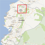
FSX/P3D Version 3 of this scenery is a completely new build of SEQM from the ground up. The entire complex is rendered using FSX objects along with the new highway that connects to the highway infrastructure with AI road traffic. The airport is now at a mean altitude that better blends with the newly included NASA SRTM GL1 30m mesh for the region. The tower is at the correct altitude. Buildings use more accurate footprints, new models, floating jetways, and updated landclass, and work seamlessly with the roads added by FTX Global/Vector. Lakes are corrected within roughly 100 square miles. Although the Ibarra/Atahualpa (SEIB) airport no longer exists, there is an option to add it back. Startup files are included to fly from the lakes and the Ibarra/Atahualpa (SEIB) airport. As a “bonusâ€, SEQU was restored in this version, because much of the footprint of the airport still remains as part of its conversion to a park. As such, a custom and fully functional SEQU is included for users who would like to revisit the old airport. AI Traffic can be restored at SEQU by simply using the "Reversed SEQU-SEQM AI Traffic" option. Scenery was created using Airport Design Editor X v1.76.6715, SBuilderX 3.13, and the FSX Object Placement Tool. Scenery objects were added and modified from stock FSX scenery to resemble as closely as possible the actual airport. Bill Leaming's Ramp Lights for P3D/FSX illuminate the aprons.
| Filename: | North_Central_Ecuador_v3_including_SEQM_SEQU_and_S.zip |
| License: | Freeware |
| Added: | 22nd March 2020, 22:13:37 |
| Downloads: | 4,108 |
| Author: | Carlyle Sharpe |
| Size: | 29.44 MB |
| Category: Flight Simulator 2004 - Scenery | |
| Nanisivik CYSR and Arctic Bay CJX7 in Nunavut, Canada |
|
Images related to this file:
File Description:
Nanisivik is an airfield in the north of Baffin Island, 470 miles north of the Arctic circle. It was built to service a zinc and lead mine that was opened in 1976 as Canada's first Arctic mine, now closed and dismantled. The deep water Strathcona Sound has been ear-marked by the Canadian government for development as a naval base, so I have left the large ore storage shed and the jetty in place. The airfield is at 2,106 feet on the top of the Borden Peninsula hills with a lighted 6,400 feet of 150 feet wide gravel runway runway aligned 11/29. There is a terminal and other maintenance buildings, and First Air have a building there from when the mine generated a lot of traffic and jets were used. Arctic Bay is a village 11 miles west of Nanisivik airfield with a population of around 690 which also uses the Nanisivik airfield. There is another gravel strip much closer to the village that is called Arctic Bay CJX7, but this is smaller with only 1,500' of 50' wide gravel and has no facilities of any sort. The village is partly dependent on visiting sports hunters and other limited tourist visits. At almost 73 degrees north the average year will have only four or even three months where the average high is above freezing. The buildings on the field have been modelled specifically for this scenery, and as in real life there is only JetA available. The AI visiting aircraft are a Kenn Borek Twin Otter and a First Air 42-300. As Nanisivik is in the "Northern Domestic Airspace" the runway is signed in "true" bearings and not magnetic as magnetic compasses become unreliable close to the magnetic pole.
| Filename: | Nanisivik_CYSR_and_Arctic_Bay_CJX7_in_Nunavut_Cana.zip |
| License: | Freeware, limited distribution |
| Added: | 28th May 2011, 19:59:18 |
| Downloads: | 496 |
| Author: | Roger Wensley |
| Size: | 2.64 MB |
| Category: Flight Simulator X - Aircraft Repaints, Textures and Modifications | |
| Hapag Lloyd Express Boeing 787-8 and 737-700NG |
|
Images related to this file:
File Description:

Hapag Lloyd Express repaint for the wonderful TDS 787 and 737-700NG model. The textures are saved in 32bit format for quality graphics. Its features are Opening doors & Cargo doors, detailed textures, accurate paint, dynamic shine & effects, dynamic flexing wings that respond to turbulence, fully independent suspension, trim animation, gear steering, accurate flight dynamics, spoiler animation, crash effects, reflective cockpit windows, transparent navigation light lenses and many more.
For FSX and FS2004.
TEXTURES ONLY,YOU MUST HAVE THE TDS 787Genx and TDS 737-700NG Base Package.
| Filename: | Hapag_Lloyd_Express_Boeing_7878_and_737700NG.zip |
| License: | Freeware |
| Added: | 18th September 2013, 12:58:03 |
| Downloads: | 474 |
| Author: | Triadi "Achonk" Sudarmawan |
| Size: | 7.67 MB |
| Category: Flight Simulator X - Scenery | |
| Sardinia Photoreal 6/14 - Baronia and Ogliastra (1/4) |
|
Images related to this file:
File Description:
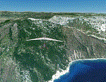
Baronia and Ogliastra are two sub-regions located along east coast of Sardinia. In Ogliastra is placed Arbatax - Tortoli airport (LIET). Part 1 of 4 (baronia_ogliastra_2.4.zip, baronia_ogliastra_3.4.zip and baronia_ogliastra_4.4.zip are required).
Credits: Aerial photos summer 2012 courtesy of Microsoft Virtual Earth.
| Filename: | Sardinia_Photoreal_614__Baronia_and_Ogliastra_14.zip |
| License: | Freeware |
| Added: | 16th June 2013, 02:21:11 |
| Downloads: | 3,297 |
| Author: | Diego PAPARELLA |
| Size: | 487.35 MB |
| Category: Flight Simulator 2004 - Scenery | |
| "Himalayan Peaks" LOD10 Mesh, Volume 7 - K2 and Karakoram |
|
Images related to this file:
File Description:

Highly detailed terrain mesh of the Karakoram area, N35-37 E73-77. The files in this package are based on Shuttle Radar (SRTM) Version 2 data but with many of the void areas, especially the most significant sections, filled with elevation data generated from topographic maps by Jonathan de Ferranti. While Jonathan's work is unrelated to flight simulation he kindly gave me permission to compile his data for use in FS. The result is a wonderful improvement in detail and accuracy over any existing mesh file, freeware or commercial, based on SRTM or DTED data alone.
Due to the large area of the Himalayas I've compiled the source data as two separate series: the "Himalayan Peaks" series covers prominent mountains and ranges in higher detail and locally overrides any existing LOD9 terrain mesh. In addition, a LOD9 "base mesh" series covering the entire Himalayas will be available for those who do not yet have an add-on terrain mesh of these beautiful mountains.
| Filename: | Himalayan_Peaks_LOD10_Mesh_Volume_7__K2_and_Karako.zip |
| License: | Freeware, limited distribution |
| Added: | 30th May 2010, 09:56:27 |
| Downloads: | 9,476 |
| Author: | Holger Sandmann, Jonathan de Ferranti |
| Size: | 38.58 MB |


© 2001-2026 AVSIM Online
All Rights Reserved
Privacy Policy |