
Where Flight Simulation Enthusiasts Gather from Around the World!
AVSIM Library - Search Results

| Category: Flight Simulator 2004 - Scenery | |
| Alps LOD10 Topo Mesh - Austria and Italy |

|
Images related to this file:
File Description:
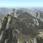
Yet another terrain mesh package of the European Alps? Well, this one is different in that it is NOT primarily based on the Shuttle Radar (SRTM) data with their incomplete coverage of prominent peaks and ridges. Instead, most of the source data for this project were developed over many months by Jonathan de Ferranti using detailed topographic maps. While Jonathan's work is unrelated to flight simulation he kindly gave me permission to compile his data for use in FS. The result is a wonderful improvement in detail and accuracy over any existing SRTM- or DTED-based mesh file, freeware or commercial (a link to an extensive set of screenshot comparisons is included in the read-me file).
I've compiled the source data at LOD10 (38-m) grid resolution because the coverage area is smaller than most existing mesh files. Thus, anyone can use these files without having to first uninstall their current mesh set. Also included are LOD9 and LO8 buffer mesh files. Note: if you own Austria Professional 2004 with its 1:50,000 scale terrain mesh then you don't need this package!
| Filename: | Alps_LOD10_Topo_Mesh__Austria_and_Italy.zip |
| License: | Freeware, limited distribution |
| Added: | 30th May 2010, 09:46:58 |
| Downloads: | 62,954 |
| Author: | Holger Sandmann, Jonathan de Ferranti |
| Size: | 73.32 MB |
| Category: Flight Simulator X - Utilities | |
| FS Recorder 1.3 for FSX |
|
File Description:
FS Recorder is an add-on module available for FS2004 and FSX. It allows recording and playback of flights, similar as the instant replay and video recorder built into FS, but with a lot more features. The recorded flights can be played back either using the user's aircraft or as AI traffic, which allows you to fly formations with yourself. A number of settings allow to customize FS Recorder to your needs. The recorded flights are saved in a binary file format containing flight data and can thus only be played back inside FS. These files are no video files, so it is NOT possible to play them with a video or media player, or to convert them into video files.
Features: recording flights of unlimited length * optional recording and playback of AI traffic * playback of one or multiple recordings as AI traffic * recording new flight during playback as traffic * replay of the last minutes, even if no recording was started * jumping and searching during playback * playback control via keyboard or control window * stop playback at any position to continue manually * loop part of a recording * change playback speed * custom keyboard controls * recorded data is customizable.
| Filename: | FS_Recorder_13_for_FSX.zip |
| License: | Freeware |
| Added: | 31st December 2007, 15:43:47 |
| Downloads: | 7,915 |
| Author: | Matthias Neusinger |
| Size: | 382.05 KB |
| Category: Flight Simulator 2002 - Scenery | |
| AAA Anti-Aircraft Effect |
|
File Description:
I can't put a photo up because it won't show the tracers. This is the .fx files and controller for four AAA positions at PHNG airfield in Hawaii. Not a lot of traffic at that field, or in the area online so I used it for my test site. As you fly into the base you will see four sets of tracers protecting the field. Tracers here are organish-yellow, not green. Sorry to disappoint the CNN/Gulf War fans who think they should be green. The BGLs I have included show placements of the guns and should be added to your ADDONSCENERY/SCENERY directory. Put the .fx files in the effects directory, and the .bmp in the effects/texture directory...have fun.
| Filename: | AAA_AntiAircraft_Effect.zip |
| License: | Freeware |
| Added: | 12th December 2002, 12:50:00 |
| Downloads: | 938 |
| Author: | Brian Smith |
| Size: | 4.3 KB |
| Category: Flight Simulator 2002 - Scenery | |
| Pacific Northwest Illustrated Scenery Catalog - CANADA |
|
File Description:
Constant additions of scenery for FS2002 have resulted in the neccessity of two separate catalogs (Microsoft Word format), one covering the US northwestern states and one for Canada; rather than my old editions that covered both. This one for the Canadian western provinces has over 60 files of scenery for British Columbia, Northwest Territories and the Yukon Territories. Updated links. Plenty of screenshots. Unless the sim community is overwhelmed with new scenery developments for this area over the next few weeks, this should do it for awhile. Although I have been meticulous in searching these files out, there is bound to be a few I missed. If you are or become aware of them, I would appreciate your bringing them to my attention.
| Filename: | Pacific_Northwest_Illustrated_Scenery_Catalog__CAN.zip |
| License: | Freeware, limited distribution |
| Added: | 25th November 2002, 20:14:38 |
| Downloads: | 1,207 |
| Author: | Heather Sherman |
| Size: | 2.89 MB |
| Category: Flight Simulator 2004 - Aircraft Repaints, Textures and Modifications | |
| McDonnell DouglasMD-83 (Default - Flyable) Update |
|
File Description:
This update was designed for FS users who downloaded the "Flyable default MD-83", available at Simviation and AVSim (filename: md83_flyable.zip).
A small bug was noticed when the user loads the MD-83 in FS2004 and no checklists are available on the Electronic Kneeboard when striking the F10 key. It happened because the checklists provided in that ZIP file were in HTML extension, and the FS2004 Electronic Kneeboard can only handle files with HTM extension.
So, now these are updated checklists, with some more information added in the "Reference Data" page, and both files are now in HTM extension.
The FS2002 MD-83 checklists don't need update and are working fine.
This is an update only. You need the "md83_flyable.zip" file to use this update.
| Filename: | McDonnell_DouglasMD83_Default__Flyable_Update.zip |
| License: | Freeware, limited distribution |
| Added: | 7th August 2004, 08:08:34 |
| Downloads: | 1,001 |
| Author: | Luciano Ferreira |
| Size: | 62.04 KB |
| Category: Flight Simulator 2004 - Scenery | |
| Placerville (KPVF) Scenery Update |
|
File Description:
An Update to the KPVF Placerville Scenery files. This update has two files, an AFCAD which has an additional GA parking spot named "W Parking 1". If you select this as your start location you will start your flight inside a green T hanger at the far end of the field where most of the additional scenery is placed. Also a new scenery file which has a lot more trees added to the northern area, which is what you see on the aerial photo. Also it corrects an error in which a stack of crates are hovering above the ground near the end of the parking ramp. You will need the original exclude file in the first KPVF Scenery so this is not a stand alone install.
| Filename: | Placerville_KPVF_Scenery_Update.zip |
| License: | Freeware |
| Added: | 21st March 2006, 23:39:23 |
| Downloads: | 351 |
| Author: | Kim Gowney |
| Size: | 5.17 KB |
| Category: Flight Simulator 2004 - Miscellaneous Files | |
| MultiConfig 1.0.3 Multilanguage |
|
File Description:
This is a program that permits you to save fs9.cfg, scenery.cfg, *.ini, and other files, with a specific name. You can save many differents names, to have many configurations, like plane, helicopter, rocket, balloon... You can also start the program with a parameter, (the name you saved) and MultiConfig replace files and launch the application which is assiociated with (like FS9.exe).Translation is not my job, so please, tell me if something is really bad... Le programme permet de sauvegarder les fichiers de configuration de Flight simulator 2004, tel que fs9.cfg, ou fsuipc.ini, par exemple, et de pouvoir les replacer à la demande, ainsi que démarrer fs9.exe. Pour le reste, consultez les fichiers contenus dans le zip
| Filename: | MultiConfig_103_Multilanguage.zip |
| License: | Freeware |
| Added: | 23rd January 2006, 04:15:21 |
| Downloads: | 640 |
| Author: | Benoît Jahény |
| Size: | 1.14 MB |
| Category: Flight Simulator X - Scenery | |
| Lake Kipawa - Quebec bush scenery |
|
File Description:
This scenery is fictitious and created for the pleasure of all. All the objects are already included in FSX and no other library was used. Seaplane base Kipawa is located on the North side of the lake, and this place is meant to be a site of free time for small boats. It can also be a refueling place for seaplanes. Lake Kipawa is situated at the far South West coast of Quebec, in the region of Abitibi-Temiscamingue. Must have before installing the Aerovirtuel bush flying sceneries:
1-Quebec Elevation 38m (LOD10) Gilles Gauthier sur http://avsim.com/ 5 files.
2-Quebec Scenery - Lakes and Rivers (1/5) http://avsim.com/ 5 files and one fix
3-Quebec Scenery - Addition of Roads http://avsim.com/
| Filename: | Lake_Kipawa__Quebec_bush_scenery.zip |
| License: | Freeware, limited distribution |
| Added: | 10th November 2007, 22:15:04 |
| Downloads: | 838 |
| Author: | Denis Dupuis |
| Size: | 1.01 MB |
| Category: Flight Simulator X - Scenery | |
| Lake Magpie - Quebec bush scenery |
|
File Description:
This scenery is fictitious and created for the pleasure of all. All the objects are already included in FSX and no other library was used. This scenery simulates the Headquarters of Aérovirtuel bush flying section for the region of Duplessis, Qc. The Lake Magpie is about 100Km North West of Havre St-Pierre. This place is hilly but perfect for a quick response for emergencies in the East part of Québec. This base has all services, oil gaz included.Must have before installing the Aerovirtuel bush flying sceneries:
1-Quebec Elevation 38m (LOD10) Gilles Gauthier sur http://avsim.com/ 5 files.
2-Quebec Scenery - Lakes and Rivers (1/5) http://avsim.com/ 5 files and one fix
3-Quebec Scenery - Addition of Roads http://avsim.com/
| Filename: | Lake_Magpie__Quebec_bush_scenery.zip |
| License: | Freeware, limited distribution |
| Added: | 10th November 2007, 22:15:41 |
| Downloads: | 846 |
| Author: | Denis Dupuis |
| Size: | 416.57 KB |
| Category: Navigation and ATC - Navigation | |
| Lake Huron Chart Chunks Optimized For Moving Map Application |
|
File Description:
Sectional chart chunks made from the August 2009 Sectional charts at the original scale, formatted in the WGS84 lat/lon geographic coordinate system for GPS, moving map application for flight simulation use.
These chart chunks were converted to the JPEG format for compatibility and size. Coverage is the full Sectional area North and South divided into 8 JPEG tiles. They are about 3k x 3k pixels at 2.5mb with coverage of 90nm x 130nm per tile. Included is also the projection files and world files.
Note: This type of map is a equal grid and no further calibration is needed, only the two points referenced in the world file. Example: for users of FSM Moving Map, just mass import, done.
| Filename: | Lake_Huron_Chart_Chunks_Optimized_For_Moving_Map_A.zip |
| License: | Freeware |
| Added: | 20th February 2010, 22:08:53 |
| Downloads: | 129 |
| Author: | David Myers |
| Size: | 20.82 MB |


© 2001-2026 AVSIM Online
All Rights Reserved
Privacy Policy |