
Where Flight Simulation Enthusiasts Gather from Around the World!
AVSIM Library - Search Results

| Category: Flight Simulator 2004 - Flight Plans | |
| World Challenge Western Brazil |

|
File Description:
In this challenge you need to pack a lunch with you. There are some long hauls in this challenge and you start at night with with your light fully on. You will have to get above 3000 feet quickly to keep for hitting the egde of the mountain.
For this challenge you will need to use the Beechcrafts King Air, Baron 58, Cessna C182S Skylane, and Mooney Bravo. These are the only aircrafts you can use for this challenge. I have included a NAV Log so you know what airfield to fly to. You are going deep into the Amazon Jungle and then from there into Paraguay where the challenge dont stop there. So get ready for some fun and Oh watch the tree top when you land.
| Filename: | World_Challenge_Western_Brazil.zip |
| License: | Freeware |
| Added: | 29th June 2007, 07:08:18 |
| Downloads: | 308 |
| Author: | Hosea Robertson |
| Size: | 2.81 KB |
| Category: Flight Simulator 2004 - Scenery | |
| Israel SRTM 90m Mesh Ver. 1.0 |
|
File Description:
Finally, VFR/CVFR pilots are able to enjoy the tall peaks of the Hermon mountain, the Golan heights and the ravines of the Western slopes of the Carmel mountains, the road to Jerusalem and the sub-sea level features of the Sea of Galilee and the famous Dead Sea.
The Negev Desert can finally show off its fascinating topography which includes, among others, the Small Crater and Ramon Crater whose features are clearly visible from space. There are many canyons, ravines, dry streams and other dramatic ground landscapes which can make a Negev Dessert VFR Expedition quite exciting. The trip could end at Eilat. Now you can see this well known touristic resort, bordered on the West and East by the tall and rugged mountains which have been among its more typical features.
| Filename: | Israel_SRTM_90m_Mesh_Ver_10.zip |
| License: | Freeware, limited distribution |
| Added: | 23rd April 2004, 12:54:03 |
| Downloads: | 12,086 |
| Author: | Alexander Lawrence |
| Size: | 7.26 MB |
| Category: Flight Simulator 2004 - Scenery | |
| Colorado Lakes Project IV |
|
File Description:
This project features the lakes of North Central Colorado, replaces all of the prominent reservoirs and lakes of the region (Dillon, Green Mountain, Granby, Williams Fork, and more), and adds over 500 highly detailed lakes to Colorado. They fit seamlessly with my "Colorado Lakes Project III" (colorado_lakes_project_3.zip), "Colorado Lakes Project II" (colorado_lakes_project_2.zip) and "Colorado Lakes Project I" (colorado_lakes_project_1.zip) lakes.
These lakes are specifically designed to show off their photo realistic detail when used in combination with "FSGenesis-The Rockies 38.2m Terrain Mesh-Colorado" available as "fsg_dem38m_usrk_co.zip" at avsim.com, or comparable mesh. The free FSGenesis US National Landclass Project Beta 6 also adds beautifully to the landscape. These lakes work equally as well with the default mesh.
All lake information was projected from satellite imagery and compiled with a beta version of Jim Keir's "Slartibartfast" utility.
| Filename: | Colorado_Lakes_Project_IV.zip |
| License: | Freeware |
| Added: | 10th June 2004, 04:27:10 |
| Downloads: | 4,829 |
| Author: | Carlyle Sharpe |
| Size: | 743.4 KB |
| Category: Flight Simulator X - Scenery Design | |
| ChopperWorld FSX Strobe Collection |
|
File Description:
This Finney Air ChopperWorld FSX Strobe Collection for Instant Scenery contains helicopter related strobe/fixture sets in various sizes of square, round and triangular configurations, as well as a single strobe fixture.
The collection contains two effects-only strobe sets which will allow Instant Scenery users of Finney Air FS9 ChopperWorld to install strobe effects over the non-functioning strobe fixtures attached to several of the ChopperWorld pads & towers.
The collection also includes an invisible landable platform w/strobe effects only, no strobe fixtures. Since the previously released Finney Air FSX Landable Platform collection platforms are only semi-invisible, this invisible landable platform is specific to repairing the landable platforms/strobe fixtures of the ChopperWorld mountain and offshore towers which featured see-through metal grate landing surfaces which in FSX are non-functioning, refer to README file for placement suggestions.
| Filename: | ChopperWorld_FSX_Strobe_Collection.zip |
| License: | Freeware |
| Added: | 10th October 2010, 19:55:26 |
| Downloads: | 662 |
| Author: | Gary Mills |
| Size: | 1.35 MB |
| Category: Flight Simulator 2004 - Scenery | |
| CPair Executive Island CALU |
|
File Description:
This is CPair's Executive Island, the corporate getaway. At this marvelous airport is the VA CEO's house. This airport will play host to meetings, pilot registration, conferences, and many other administrative activities. When you come to CALU you can come see Ludo's car and house, or have a Big Mac at the nearby McDonald's, When you are at CPair Executive Island you might hear a wolf's howl at night, seagulls, a horses' nay, and many other sounds that help bring CALU to life. CALU is located not far off of CPair International, in Blue Mountain Ontario. Executive Island still
remains in Ontario and is a lovely island to host our Executive Airport. If you would like to join or visit CPair please visit http://s8.invisionfree.com/Canadian_Pilots/. You require Lago FSE to be able to use this airport.
| Filename: | CPair_Executive_Island_CALU.zip |
| License: | Freeware |
| Added: | 10th February 2005, 02:44:03 |
| Downloads: | 541 |
| Author: | Ludo Lambrechts |
| Size: | 2.35 MB |
| Category: Flight Simulator 2002 - Flight Plans | |
| 35RTWest |
|
File Description:
An FS2002 GPS flight Plan. The 35th in a series of Round the World flight plans for the FS2002 default scenery. Depart Paro (VQPR) runway 33, Bhutan and arrive 1 hour 02 minutes later at Tribhuvan International (VNKT) runway 02, Nepal. A steep takeoff to avoid the banking around the runway is followed by a climb up a valley before passing through a gap in the snow capped mountain peaks at FLl90. An optional flight situation file is provided to assist inexperienced pilots with this very tricky departure. At the highest point in the flight, FL280, you will still be overlooked as you pass the snow capped peak of Everest. The flight briefing (Word and text) is for a B737-400, it contains climb, cruise, top of descent and fuel loading details, waypoint timings and destination details.
| Filename: | 35RTWest.zip |
| License: | Freeware |
| Added: | 13th July 2002, 18:23:40 |
| Downloads: | 1,390 |
| Author: | The Ancient Brit |
| Size: | 56.92 KB |
| Category: Flight Simulator 2004 - Scenery | |
| "Caiolo" Sondrio Airport, Valtellina, North Italy |
|
Images related to this file:
File Description:
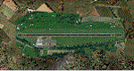
In this airport reside AvioValtellina and VolaValtellina, as well as the operational base of the Health Service 118 and Mountain Rescue. It also base of the Aeroclub Sondrio with its Flight School VDS. Site at the beginning of the Valtellina, in Caiolo municipality (N46 09.0 E09 48.0), has an asphalt runway from 1050x23 mts, ground communication frequency 129.50; ICAO code: LILO. It is also enclosed the base of INAER Aviation, located in Colico-Piantedo (N46 08.18 E09 24.19 - code LIEI), that operates in Medical Emergency, rescue operations in the mountains and off-shore. Scenery realized on the real cooordinates of the airport (except for elevation) including the scenery of the heliport INAER Colico. Requires the use of the libraries' dva51 "and the system of vegetations "TreePlanter".
Enjoy!
A presentation video is available here.
| Filename: | Caiolo_Sondrio_Airport_Valtellina_North_Italy.zip |
| License: | Freeware |
| Added: | 25th October 2014, 11:52:25 |
| Downloads: | 856 |
| Author: | Aldo Della Vedova |
| Size: | 29.5 MB |
| Category: Flight Simulator 2004 - Scenery | |
| Terrain Mesh of Glacier National Park |
|
File Description:
New and updated scenery enhancements for the mountain ranges of southeastern British Columbia and parts of the Alberta Rocky Mountains. They require an existing installation of my files bcmesh9d.zip and/or bcmesh9e.zip. Scenery coverage follows the Trans-Canada Highway from Banff National Park to west of Revelstoke (~350km), with accurate transportation network, rivers and lakes, hydro dams, ski hills, glaciers, and landclass/waterclass updates based on satellite imagery. Also, similar enhancements to the parks and towns of the southern Kootenay, Selkirk, and Monashee mountains. The mesh source data are 0.75-arcsec (~23-m) CDED files, compiled at LOD10 (38-m) resolution. Due to significant changes in FS2004 to vector layering and autogen features, the special scenery enhancements cannot be used with FS2002. However, terrain mesh, new lakes and land/waterclass replacements will work well in FS2002.
| Filename: | Terrain_Mesh_of_Glacier_National_Park.zip |
| License: | Freeware, limited distribution |
| Added: | 18th December 2003, 23:17:35 |
| Downloads: | 8,857 |
| Author: | Holger Sandmann |
| Size: | 12.79 MB |
| Category: Flight Simulator 2004 - Scenery Design | |
| EZ New GOLF FILES |
|
File Description:
Many have seen my golf course at Andrewsfield, England. These libraries enable you to build an 18 hole course, now, and with many added golf objects. I was asked by John B. Loney Jr. (excellent designer) to do a golf course at Oroville, CA. It is called Table Mountain Golf Course. We used course lay-out maps to design the course close as possible to real life including water hazards. One file in this download is an update which is needed; the other two are new. Be sure to have bobslibraries installed as well since I use a couple of objects from my hangar library which is part of bobslibraries. John is close to done with Oroville, CA (KOVE)along with another he is working on. Be sure to grab those when you see them! As always, comments or suggestions are appreciated. Bob
| Filename: | EZ_New__GOLF__FILES.zip |
| License: | Freeware |
| Added: | 18th August 2007, 23:57:50 |
| Downloads: | 718 |
| Author: | Robert Lacy |
| Size: | 1.72 MB |
| Category: Flight Simulator 2004 - Scenery | |
| South Farallon Islands |
|
File Description:
These islands were mysteriously absent from the FS2004 default scenery, probably owing to their small size. When I went to look for them I found a small mountain of water instead of the islands.
Most people don't seem to be aware of the Farallon Islands. Located off the coast of California, near San Francisco, they are home to thousands of birds, seals, and some of the largest Great White sharks known to man. All of this is within a very short distance of the city.
Today, it is a wildlife refuge and is off limits to visitation by the general public. Those of you interested in more info might check out "The Devil's Teeth" by Susan Casey.
This island is actually a scenery object. As such it doesn't have a landable surface. Future versions will have a helicopter pad.
| Filename: | South_Farallon_Islands.zip |
| License: | Freeware, limited distribution |
| Added: | 29th October 2005, 05:30:42 |
| Downloads: | 790 |
| Author: | Glen Gordon (Prof K.) |
| Size: | 488.04 KB |
© 2001-2026 AVSIM Online
All Rights Reserved
Privacy Policy |