
Where Flight Simulation Enthusiasts Gather from Around the World!
AVSIM Library - Search Results

| Category: Flight Simulator X - Scenery | |
| RAF Bottlesford - Lincolnshire, England |

|
File Description:
Royal Air Force Station Bottesford or more simply RAF Bottesford is a former Royal Air Force station located on the Leicestershire-Lincolnshire county border, 6.8 miles (10.9 km) north west of Grantham, Lincolnshire and 7.6 miles (12.2 km) south of Newark-on-Trent, Nottinghamshire and about 107 miles (172 km) north-northwest of London, England.
Opened in 1942, it was used by both the Royal Air Force (RAF) and United States Army Air Forces (USAAF). During the war it was used primarily as a troop carrier airfield for paratroopers and as a bomber airfield before closing in 1948.
Today the remains of the airfield are located on private property with the technical site being used as an industrial estate.
Third party add-on's will be required to see all the building included in the scenery, you will need Ted Andrews RAF Small Buildings and his hanger library, for the vehicles Ian Pearson FSX Object library will be required, the RAF Ensign hedges are the from Mike Hudson's scenery. All of which are available from Ian Pearsons' website; www.ianpsdarkcorner.co.uk.
| Filename: | RAF_Bottlesford___Lincolnshire_England.zip |
| License: | Freeware |
| Added: | 10th October 2015, 11:37:40 |
| Downloads: | 345 |
| Author: | Terry Boissel |
| Size: | 15.94 KB |
| Category: Flight Simulator X - Scenery | |
| RAF Metheringham - Lincoln, Lincolnshire, England **FIX** |
|
File Description:
This is a fix which will sort out the scenery configuration error which prevented the scenery from showing.
Metheringham airfield is located two miles to the east of Metheringham village on the B1189. The airfield opened in October 1943 as a Class 'A' bomber airfield within 5 Group. The standard three intersecting concrete runways were provided as were two T2 hangars and a B1. One of the T2s was on the technical site to the south-west, which straddled the B1189 and the other was located off the eastern perimeter track. The bomb stores were to the north and between these and the north-west runway head stood the B1 hangar. The communal and accommodation sites were located in fields to the south and west. Metheringham was also equipped with FIDO fog dispersal equipment. The station closed in 1951 and very little remains of the station now although a small visitors centre with a little museum on site.
You will require third party add-ons - details in the included Read-me.txt file.
| Filename: | RAF_Metheringham__Lincoln_Lincolnshire_England__FI.zip |
| License: | Freeware |
| Added: | 15th November 2015, 14:25:30 |
| Downloads: | 206 |
| Author: | Terry Boissel |
| Size: | 95.84 KB |
| Category: Flight Simulator 2004 - Scenery | |
| Clinton Point CWCP, Horton River CWHR & Keats Point CWKP; DEW sites in Northwest Territories, Canada |
|
Images related to this file:
File Description:
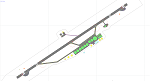
These are three DEW line sites in northern mainland Canada, to the east of Tuktoyaktuk.
Clinton Point is almost 300 miles east of Tuktoyaktuk and on the Northwest Territories and Nunavut border. It is the site of a closed DEW station (closed in 1993) and all the buildings have been removed, unlike many other sites where buildings are still almost complete. The roads and the gravel runway down by the beach are still there.
Horton River is 150 miles east of Tuktoyaktuk, up on higher land above the cliffs at around 500 feet ASL. The NWS (North Warning System) replaced the I site which was there previously and which ceased operations in 1963. The NWS is serviced by helicopter from a barge 400 yards away on the beach.
Keats Point is 270 miles east of Tuktoyaktuk, 7 miles from the coast but significantly close to a lake, which was probably used for float plane delivery in the summer (or ski plane delivery in the winter) of NWS station elements during construction.
| Filename: | Clinton_Point_CWCP_Horton_River_CWHR__Keats_Point_.zip |
| License: | Freeware, limited distribution |
| Added: | 17th July 2012, 18:57:08 |
| Downloads: | 278 |
| Author: | Roger Wensley |
| Size: | 2.07 MB |
| Category: Flight Simulator X - AFCAD Files | |
| TKPK - Robert L. Bradshaw International Airport / Saint Kitts and Nevis |
|
Images related to this file:
File Description:
This airport update was made with the latest version of ADE (Airport Design Editor) and made for FSX as a replacement for the stock (default) airport. I've made several changes to the airport which are listed below. All these enchancements are as close to the real airport as I can get with stock library objects. I've used satellite images, terminal photos and maps throughout the whole process so building locations are as accurate as possible. Happy landings in sunny Saint Kitts and Nevis!
Features:
*Expanded parking apron
*Main terminal building with parking area for commercial traffic (Gates 1-9)
*St. Kitts airport sign
*Seperate parking area for GA traffic
*Parking stand for cargo (Gate 9)
*Misc airport buildings added
*Airport vehicles and objects throughout the airport
*Fuel tanks and station
*Airport fire station
*Windsocks added
*Birds flying near runway (beware)
*Palm trees/vegitation added near terminal
*Taxiway signs
*Taxiways Bravo and Charlie properly assigned
*New taxiway Alpha added
(For more information about Endeavourai please visit our site at endeavourai.com)
| Filename: | TKPK__Robert_L_Bradshaw_International_Airport__Sai.zip |
| License: | Freeware |
| Added: | 1st September 2012, 21:23:20 |
| Downloads: | 816 |
| Author: | Jaison Diaz / Endeavour ai |
| Size: | 87.92 KB |
| Category: Flight Simulator X - Scenery | |
| Area 51 V1.1 |
|
Images related to this file:
File Description:
In V1 I added tower comms, taxiways/signs, and deleted start points for all those dirt & other closed runways and made the primary/secondary 14/32.
In V1.1 I have gone through the rest of the airport, aligning and cleaning up scattered oddly placed buildings and placed them in a logical manner - aligned with roads. with parking lots and/or pavement or concrete around their base. Gravel roads added thru the warehouses, sand maintenance roads to water tower and power station, Rec center pool and ballfield touched up. Fire station is in same place but turned towards flight line and added the trucks an ambulance. Fencing all around the flight line.
Also you get the F-117 and Janet 737 WITH traffic file. The Janet 737 is the shuttle aircraft for the Area 51 workers. Watch as the Janet flights arrive each morning from KLAS and depart each night Mon-Fri. KLAS (Las Vegas) Bgl also included with assigned parking at the Janet Terminal.
| Filename: | Area_51_V11.zip |
| License: | Freeware |
| Added: | 24th October 2014, 11:47:01 |
| Downloads: | 2,453 |
| Author: | Jeff Reed |
| Size: | 17.66 MB |
| Category: Flight Simulator 2002 - AFCAD Files | |
| China Lake NAWS, CA. AFCAD JANET |
|
File Description:
This is the AFCAD to a top secret facility known as China Lake Naval Air weapons station in California. The stories are wide and far ranging about this secret place in the desert.
There is a supposed underground tram system running 180 MPH under the Death Valley mountains to Area 51. (some reports of the tram running up to 275 MPH) Lockheed has a targeting and ranging station on base used to develop aircraft that are invisible. (the craft blend with the sky) Orbs can be seen here, UFO's reported daily, and on and on.
Folklore,? maybe. I dont know anything. Speculation only. Gates are approximated. My work is free to the simming community. Please do not sell any of ol' Bucks work.
Please do not include my work any any pay packages. Free is good. God bless the USA. If this is subversive to the USA, please feel free to pull my AFCADS.
P.S.: SDK is included with Lee Swordys installer. I had trouble getting this AFCAD to install so good luck. That is why I have included the SDK.
| Filename: | China_Lake_NAWS_CA_AFCAD_JANET.zip |
| License: | Freeware, limited distribution |
| Added: | 6th September 2003, 17:06:33 |
| Downloads: | 471 |
| Author: | Buck Martin |
| Size: | 49.75 KB |
| Category: Flight Simulator 2004 - Scenery Design | |
| Arctic set |
|
File Description:
Finney Air presents
EZScenery Arctic set v1
This package includes 24 Arctic type items to be used with Abacus EZScenery. You MUST have EZScenery installed for this set to work.
Build your own remote station in any place of the world. Just remember where you made the station, wrong place to loose your bearings.
These include:
6 Types of "Snowcats" 2 yellow, 2 orange, 1 yellow with roof racks, and 1 orange with pax cab
1 Fully loaded Snowcat with loaded trailer
2 types of trailers, 1 for static and 1 for use as tow unit (NOTE: Trailers not designed for helicopter landings)
1 Small cargo box
1 long cargo box
1 Fuel drum
1 fuel drum with pump
1 Pallet
1 Green expedition tent
3 smaller tents in red, green, and blue
1 Polar First flag on pole
1 VERT flag on pole
1 Scientists work table with gear on it
1 Main base with sat. tower (WARNING:may be a bit on frame rate)
1 Bunk house (not pictured)
1 Sat. tower (not pictured)
| Filename: | Arctic_set.zip |
| License: | Freeware |
| Added: | 2nd March 2007, 14:50:26 |
| Downloads: | 2,319 |
| Author: | Finney Air / Rob Finnegan |
| Size: | 1.25 MB |
| Category: Flight Simulator 2004 - Aircraft Repaints, Textures and Modifications | |
| Delta Air Lines Boeing 737-800 Retired Liveries Pack |
|
Images related to this file:
File Description:

The 737-800 is a core member of Delta's domestic fleet. The first 737-800 was delivered to the airline in 1998, and since then the fleet has grown to over 70 aircraft. This package features the two previous Delta liveries worn by this aircraft; the 1997 "Ron Allen" scheme and the 2000 "Wavy Gravy" livery. Wavy gravy also has two variations, one with a more rounded widget logo, and the other with winglets and a sharper logo. Model developed by Tenkuu Developers Studio, features high resolution textures, dynamic flexing wings, nose gear steering, rudder lock, ground spoilers, low speed aileron locks at high speed, fully animated control surfaces, fully independent suspension, trim animation, opening passenger doors, rolling wheels, animated thrust reversers with reverser block doors, detailed textures, full night lighting, ground service vehicles and more. Model design by Hiroshi Igami. Flight dynamics design by Nick Wilkinson, with assistance from David Biggar. Master textures and paint kit by Kyle Schurb. Painted on the great TDS model. Enjoy!
| Filename: | Delta_Air_Lines_Boeing_737800_Retired_Liveries_Pac.zip |
| License: | Freeware |
| Added: | 14th January 2014, 06:16:02 |
| Downloads: | 625 |
| Author: | Joe Shimmel / Tenkuu Developers Studio |
| Size: | 29.82 MB |
| Category: Flight Simulator X - Scenery | |
| KORD-Chicago O'Hare 2018 |
|
File Description:
Chicago O'Hare 2018
===================
This airport has been undergoing frequent change ever since I first landed there in 2005. Fortunately, the core buildings have remained essentially the same, but runways have come and some have gone.
I got very close to releasing a 2016 version, but held back for more data. Then I looked again this year and discovered another runway gone, new ones in construction etc.
So, what I have decided to release is basically as up to date as I can make it, using Google Earth to judge the state of things in March 2018, and Charts from August 18th 2018. A lot of Taxiway labelling has changed yet again, and I dare say I've missed some of the taxi signs. One taxiway isn't on the March image, but is on the chart, so I've added it as best I can.
I think this will always be a work in progress.
| Filename: | KORDChicago_OHare_2018.zip |
| License: | Freeware |
| Added: | 20th August 2018, 15:50:08 |
| Downloads: | 1,769 |
| Author: | Martin Connor |
| Size: | 20.5 MB |
| Category: Flight Simulator 2004 - Scenery | |
| Galena PAKP in Alaska |
|
Images related to this file:
File Description:
Galena is a village on the Yukon River, around 30 miles east of the corner where the westward running river turns south. The population is just under 500 and the city is noted for its educational facilities that attract residential students from across the state. Adjacent to the city is the Galena Air Force Station that previously shared the use of the Edward G. Pitna Snr. airport until 2007, when the station was closed and the air force personnel left. The station facilities have been taken over by the community and the airport became the largest state-maintained airport in the interior of Alaska. Substantial resurfacing and finishing work was then carried out, and the new asphalt runway is now 6,000 feet long and aligned 7-25, with VASI at both ends and ILS on 25. There is a secondary gravel runway beside part of the main asphalt runway, and this is treated in radio announcements as if it is not a separate runway and landing or take off are on the adjacent asphalt. The airport is serviced by ERA (now called Ravn) and Wrights Air, with cargo flights by the eternal Everts. Included here is a small modification for Allakaket, which deletes a single remaining stock FS9 taxiway light. The AI included here also provided Allakaket with a Saturday Everts delivery flight, but I neglected to mention that before. A note here about my scenery making. There will not be many more to follow this as I am almost at the end of the photos I either took or found for scenery purposes, plus I expect to move on from FS9 at some point during next year.
| Filename: | Galena_PAKP_in_Alaska.zip |
| License: | Freeware, limited distribution |
| Added: | 27th November 2019, 19:14:00 |
| Downloads: | 256 |
| Author: | Roger Wensley |
| Size: | 13.95 MB |
© 2001-2026 AVSIM Online
All Rights Reserved
Privacy Policy |