
Where Flight Simulation Enthusiasts Gather from Around the World!
AVSIM Library - Search Results

| Category: Fly! II - Scenery | |
| Central London 1b |

|
File Description:
New Buildings for the London Scenery including Tower Bridge, Trafalgar Square, Charing Cross Railway Station and the Millenium Bridge, also night textures added to my previous work. please note you will also need to download C-London1a.zip
| Filename: | Central_London_1b.zip |
| License: | Freeware |
| Added: | 14th August 2005, 16:02:34 |
| Downloads: | 357 |
| Author: | Daniel Arias |
| Size: | 23 MB |
| Category: Flight Simulator X - Scenery | |
| Berkeley Marina v2 |
|
File Description:
This file is to add boats, docks (including sea plane docks and fuel station) and birds to the Berkley Marina. This file adds to the FS motto "As real as it gets" and the living world feature.
| Filename: | Berkeley_Marina_v2.zip |
| License: | Freeware, limited distribution |
| Added: | 2nd January 2008, 22:39:35 |
| Downloads: | 1,792 |
| Author: | Orion Lyau |
| Size: | 1.82 MB |
| Category: Flight Simulator 2004 - Aircraft Repaints, Textures and Modifications | |
| English Electric Lightning XS895 LSF 1976 |
|
Images related to this file:
File Description:
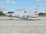
FS2004 repaint for the payware Alphasim/Virtavia English Electric Lightning. You will need to have this package on your system in order to use this repaint.
F6 XS895 Leuchars Station Flight in natural metal, RAF Leuchars 1976
| Filename: | English_Electric_Lightning_XS895_LSF_1976.zip |
| License: | Freeware, limited distribution |
| Added: | 8th January 2014, 21:09:54 |
| Downloads: | 96 |
| Author: | Daryl Payne |
| Size: | 3.76 MB |
| Category: Flight Simulator X - Scenery | |
| RAF Dunholme Lodhe - Lincolnshire, England |
|
File Description:
RAF Dunholme Lodge was a Royal Air Force station located between the parishes of Welton and Dunholme in Lincolnshire, England.
The grass airfield was first used by the Royal Air Force during 1941 and 1942 for use by Handley Page Hampden aircraft from nearby RAF Scampton, and was officially opened as a RAF Station in September 1942 as part of RAF Bomber Command with the building of three hard runways.
The main occupier of the station was 44 Squadron, with the Avro Lancaster four-engined heavy bomber, which moved in from RAF Waddington in May 1943 and stayed until it moved to RAF Spilsby in September 1944.
In November 1944 flying operations ceased due the proximity of other stations which did not allow night flying. At the end of the war 120 Lancasters had been lost on operations from Dunholme Lodge.
| Filename: | RAF_Dunholme_Lodhe__Lincolnshire_England.zip |
| License: | Freeware |
| Added: | 15th October 2015, 17:48:06 |
| Downloads: | 177 |
| Author: | Terry Boissel |
| Size: | 13.75 KB |
| Category: Flight Simulator 2004 - Scenery | |
| Lady Franklin Point CWLF in Nunavut, Canada |
|
Images related to this file:
File Description:
Lady Franklin Point was a DEW line station on the southwest corner of Victoria Island, and then a North Warning System station until January 2000 when there was a fire. As a result there are now no NWS buildings, and no central long DEW line station building, only the outlying and already unused buildings from the DEW line site. However, the runway is still there and over 5,000 feet of gravel in length, aligned and signed 90T/270T, though on the atc it will be called 55/235 as FS9 knows nothing about the Canadian Northern Domestic Airspace. There is no runway lighting. Kugluktuk is around 80 miles to the southwest, on the mainland.
I should have mentioned a long time ago that to see the apron lights working (on my fields that HAVE apron lights) requires you to have the "lights_ss_v2" by Sidney Schwartz installed.
| Filename: | Lady_Franklin_Point_CWLF_in_Nunavut_Canada.zip |
| License: | Freeware, limited distribution |
| Added: | 10th November 2012, 04:04:06 |
| Downloads: | 260 |
| Author: | Roger Wensley |
| Size: | 1.81 MB |
| Category: Flight Simulator X - Scenery | |
| RAF Attlebridge - Norwich, Norfolk, England |
|
File Description:
RAF Attlebridge is a former Royal Air Force station located near Attlebridge and 8 miles (13 km) northwest of Norwich, Norfolk, England. RAF Attlebridge was an early wartime station, laid out for use by No. 2 Group RAF light bombers, and was completed in August 1942. The airfield was used by No. 88 Squadron RAF from August 1941 to September 1942 using Bristol Blenheim IVs and Douglas Bostons.
The Station had runways of 1,220, 1,120 and 1,080 yards length but, when the base was earmarked for USAAF use, these were extended and the airfield was enlarged to meet heavy bomber requirements. The main E-W runway was increased to 2,000 yards and the others to 1,400 yards each. The perimeter track was also extended and the number of hardstands was increased to fifty. In enlarging the airfield, several small, country roads were closed in the parish of Weston Longville, in which the larger part of the airfield was sited.
RAF Attlebridge was assigned to the United States Army Air Forces (USAAF) Eighth Air Force's 2nd Bomb Wing on 30 September 1942. It was given USAAF designation Station 120.
Third party add-on scenery will be required - see readme for details.
| Filename: | RAF_Attlebridge___Norwich_Norfolk_England.zip |
| License: | Freeware |
| Added: | 4th January 2016, 16:32:15 |
| Downloads: | 329 |
| Author: | Terry Boissel |
| Size: | 1.04 MB |
| Category: Flight Simulator 2004 - Scenery | |
| RAF Middleton St. George |
|
Images related to this file:
File Description:
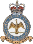
Representative scenery of RAF Middleton St. George in County Durham.
The airfield began its life as Royal Air Force Station Goosepool, and in 1941 became RAF Middleton St. George. The aerodrome opened as a Bomber Command station in 1941. In 1943 it was allocated to No. 6 Group, Royal Canadian Air Force. A sub-station was located at RAF Croft, Yorkshire. Squadrons based here include: 76 Squadron, which flew Halifaxes, 78 Squadron, which flew Whitleys, 419 Squadron RCAF, which flew Wellingtons, Halifaxes, and Lancasters, 420 Squadron RCAF, which flew Wellingtons, and 428 Squadron RCAF, which flew Wellingtons, Halifaxes, and Lancasters.
After the war, the aerodrome served various squadrons and units including No. 13 Operational Training Unit (OTU), No. 2 Air Navigation School, No. 4 Flight Training School, 226 OCU and squadrons that used Meteors, Hunters, Javelins and Lightnings.
The RAF left the station in 1964, but the aerodrome was reopened in 1966 as a civil airport. The airfield was named Teesside International Airport in the 1960s, and was renamed Durham Tees Valley Airport in 2004.
This scenery has been made using various scenery libraries, mainly from MAIW. Full listing in the docs.
| Filename: | RAF_Middleton_St_George.zip |
| License: | Freeware, limited distribution |
| Added: | 22nd June 2014, 18:31:59 |
| Downloads: | 1,181 |
| Author: | Brian Clarke; Daryl Payne |
| Size: | 3.84 MB |
| Category: Flight Simulator 2004 - Scenery | |
| Komakuk Beach & Storm Hills DEW sites in Yukon and Northwest Territories, Canada |
|
Images related to this file:
File Description:
These are DEW line sites in northern mainland Canada, to the west of Tuktoyaktuk.
Komakuk Beach CWKB is not included in FS9 and is in the Yukon, only 20 miles from the Alaska border. It is, as the name suggests, close to the sea, and the gravel runway 3,600' by 125' has its western end almost on the beach.
There is no lighting and no signage and the airfield is officially listed as closed, but in fact is used during the annual maintenance and refuelling of the automated NWS (North Warning Station) close by and for any unscheduled servicing. This replaced the previous much older DEW station that was manned year round and had a lot more buildings.
Storm Hills CWSH is in the Northwest Territories, 43 miles south-southwest of Tuktoyaktuk, up on higher land at 810 feet ASL. The NWS (there was no previous DEW station at this site) is serviced by helicopter from Tuktoyaktuk and has a gravel landing pad on the north side of the station. It will show on a gps and it is 5 miles west of the distinctively shaped and large Parsons Lake. This too was not in FS9.
| Filename: | Komakuk_Beach__Storm_Hills_DEW_sites_in_Yukon_and_.zip |
| License: | Freeware, limited distribution |
| Added: | 16th July 2012, 18:56:09 |
| Downloads: | 306 |
| Author: | Roger Wensley |
| Size: | 1.68 MB |
| Category: Orbiter - Orbital Stations | |
| Dockyard One Patch For Orbiter 030303 Build |
|
File Description:
Docking port patch for use with Orbiter 030303 build.
The patch is a simple docklist adjustment made to the .cfg file where the positions have been modified so you can now dock properly with the Dockyard One station.
| Filename: | Dockyard_One_Patch_For_Orbiter_030303_Build.zip |
| License: | Freeware, limited distribution |
| Added: | 10th June 2003, 18:38:46 |
| Downloads: | 1,069 |
| Author: | Creator Brian Burger - Patch Contribution Michelle Megan |
| Size: | 140.77 KB |
| Category: Civil Flight Simulators - Looking Glass Flight Unlimited 3 | |
| UKS Upgrade - Waterloo |
|
File Description:
This is an upgrade (do NOT delete previous version) to the package UKS by Cristian. It includes trains, trees, Waterloo station, street-lighting, (minor) improved models of Big Ben, London Bridge, nightlighting and a few other placed models.
| Filename: | UKS_Upgrade__Waterloo.zip |
| License: | Freeware |
| Added: | 13th May 2003, 03:39:06 |
| Downloads: | 193 |
| Author: | Robert Driscoll |
| Size: | 582.46 KB |
© 2001-2026 AVSIM Online
All Rights Reserved
Privacy Policy |