
Where Flight Simulation Enthusiasts Gather from Around the World!
AVSIM Library - Search Results

| Category: Flight Simulator X - Scenery | |
| Arnot Power Station Airfield (FAAP), South Africa |

|
Images related to this file:
File Description:
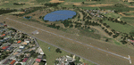
Arnot is situated at an altitude of 5580 ft. It's runway is 1158m long and only 9m wide. The airfield is owned by Escom, the sole producer of all the electricity used in South Africa. The airfield is limited to aircraft with a MAUW of 5700kg or less. The trees just short of the threshold of Runway 13 makes for an interesting approach and you better be sure about your take-off weight when taking off from Runway 31. Runway lights are also available.
Please install fsxWorx01.zip, fsxWorx02.zip and all the updates for these, before this scenery.
| Filename: | Arnot_Power_Station_Airfield_FAAP_South_Africa.zip |
| License: | Freeware |
| Added: | 2nd December 2012, 18:59:48 |
| Downloads: | 2,643 |
| Author: | Kobus van Wyk, Aeroworx |
| Size: | 7.48 MB |
| Category: Prepar3D V1-4 - Scenery | |
| EGAR Rothera Research Station and Air Facility |
|
File Description:
This is scenery of the Rothera Research Station and airstrip located on Adelaide Island in Antarctica. Rothera is the main base of the British Antarctic Survey and is populated by app. 100 scientists and support personnel in summer, while 22 hardy personnel remain on the base during the winter months. Please see the Readme file for more information and installation instructions.
| Filename: | EGAR_Rothera_Research_Station_and_Air_Facility.zip |
| License: | Freeware |
| Added: | 22nd December 2020, 19:25:33 |
| Downloads: | 206 |
| Author: | David Midgett |
| Size: | 2.18 MB |
| Category: Flight Simulator X - Scenery | |
| KCLL Easterwood Airport College Station Texas USA |
|
Images related to this file:
File Description:
Easterwood College Station Texas Airport for FSX. Several improvements have been made to the default airport. The default terminal building has been replaced with one created in FSDS; aircraft gates have been correctly coded using Airport Design Editor 1.70.6042; a new airport vehicle network has been built to prevent airport vehicles from entering the taxiways; extra fuel trucks have been added throughout the airport; the tower view has been changed to display from the roof of the control tower; all taxiway signs are correctly placed and all taxiway designators are correctly named; there is the option to open all runways to AI traffic; optionally, a set of GA flight plans is included using all default FSX aircraft to liven up the GA area; and Jim Dhaenen's excellent ramp lights are also included. Please refer to the README.txt file to insure proper installation of all files.
| Filename: | KCLL_Easterwood_Airport_College_Station_Texas_USA.zip |
| License: | Freeware, limited distribution |
| Added: | 25th November 2017, 16:08:22 |
| Downloads: | 443 |
| Author: | Patrick Finch |
| Size: | 1.09 MB |
| Category: Flight Simulator 2004 - Scenery | |
| PASY - Shemya (Eareckson Air Station) - Alaska, USA |
|
Images related to this file:
File Description:
Shemya is pretty well AT the western end of the Aleutian chain of islands in Alaska, around 240 miles west of Amchitka. There is no town on Shemya and the whole island is occupied (and owned) by the Air Force. There are three runways, two of which are from the 1940's and are now unused; in fact one of them has been partly ploughed up and also used for outdoor storage. The single in-use runway is aligned 10-28 and is 10,000 feet of 150 feet wide asphalt with an ils on 28, the runway that is used 99% of the time. The base is now not active but is maintained as a refuelling facility, so for landing and takeoff purposes it is open. The older and now unused areas are those where the hangers are slowly rusting away and the asphalt is turning green with encroaching and well-watered wildlife plants. The tower is now closed, so there is no atc and you just announce your intentions. Read the history of Shemya, a lot happened there.
| Filename: | PASY__Shemya_Eareckson_Air_Station__Alaska_USA.zip |
| License: | Freeware, limited distribution |
| Added: | 18th February 2015, 19:52:36 |
| Downloads: | 452 |
| Author: | Roger Wensley |
| Size: | 8.81 MB |
| Category: Flight Simulator X - Scenery | |
| RAF Dunholme Lodge - Lincolnshire, England **UPDATE** |
|
File Description:
This is an-update to correct the location of the Tower, if you have installed my version uploaded on the 15 or 23 Oct 15
RAF Dunholme Lodge was a Royal Air Force station located between the parishes of Welton and Dunholme in Lincolnshire, England.
The grass airfield was first used by the Royal Air Force during 1941 and 1942 for use by Handley Page Hampden aircraft from nearby RAF Scampton, and was officially opened as a RAF Station in September 1942 as part of RAF Bomber Command with the building of three hard runways.
The main occupier of the station was 44 Squadron, with the Avro Lancaster four-engined heavy bomber, which moved in from RAF Waddington in May 1943 and stayed until it moved to RAF Spilsby in September 1944.
In November 1944 flying operations ceased due the proximity of other stations which did not allow night flying. At the end of the war 120 Lancaster's had been lost on operations from Dunholme Lodge.
From 1948 the site was host to motorcycle and car racing until 1959 when the base was reopened as an active RAF station when it became an active Bloodhound surface-to-air missile station with 141 Squadron. The Squadron in 1964 and the station finally closed in 1964. Source: Wikipedia.
| Filename: | RAF_Dunholme_Lodge__Lincolnshire_England_UPDATE.zip |
| License: | Freeware |
| Added: | 28th October 2015, 18:41:50 |
| Downloads: | 262 |
| Author: | Terry Boissel |
| Size: | 335.14 KB |
| Category: Flight Simulator X - Original Aircraft | |
| FSX-P3D_Sim_Skunk_Works_Harrier_AV-8B_Spanish_Navy_Air_Tatoo_2019 |
|
Images related to this file:
File Description:
Textures for FSX-P3D Sim Skunk Works Harrier AV-8B.
Navy Spanish , 9 Squadron , Air Tatoo 2019.
Based in Naval Air Station Rota
| Filename: | FSXP3D_Sim_Skunk_Works_Harrier_AV8B_Spanish_Navy_A.zip |
| License: | Freeware |
| Added: | 12th July 2022, 18:23:00 |
| Downloads: | 39 |
| Author: | Antonio Diaz |
| Size: | 18.01 MB |
| Category: Flight Simulator X - AFCAD Files | |
| KLUF - Luke Air Force Base (Glendale - Arizona) v1.1 |
|
Images related to this file:
File Description:
Rebuilt (scale) runways, taxiways, and ramps with parking for 246 aircraft up to KC-135 in size. Includes fire station and POL facilities.
| Filename: | KLUF__Luke_Air_Force_Base_Glendale__Arizona_v11.zip |
| License: | Freeware |
| Added: | 28th April 2012, 23:06:40 |
| Downloads: | 714 |
| Author: | Allen Laughmiller |
| Size: | 27.97 KB |
| Category: Flight Simulator 2004 - Utilities | |
| RealTrim |
|
File Description:
FS9 RealTrim 1.2 Module - Improved trimming. Activate the trimming-feature via button while moving the joystick from deflection to neutral. The movement of the joystick is converted into the opposite amount of movement of the trim-wheel. This matches real-life where the pilot trims out force
felt on the yoke in ONE smooth operation: moving the trim-wheel.
| Filename: | RealTrim.zip |
| License: | Freeware |
| Added: | 13th March 2008, 04:07:40 |
| Downloads: | 3,209 |
| Author: | Nils Meier |
| Size: | 51.69 KB |
| Category: Flight Simulator X - Scenery | |
| FSX Scenery/ AI Package Stapleton International Airport Denver circa 1980 |
|
Images related to this file:
File Description:
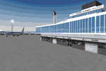
FSX Scenery and AI Package Stapleton International Airport Denver circa 1980
Custom built hangars, buildings and terminals, and landclassing for the 1980 version of Stapleton Field. Parking slots for all period traffic: Continental, Western, Frontier the locals, etc. EZ scenery, Dan French Core LibrariesVol4_FSX or higher, and some others required (see readme). AI flight plans are included for installation if you want a lot of jumbo traffic! 2 different "AFCADs" to choose from.
By Dan French and Stan Winke
| Filename: | FSX_Scenery_AI_Package_Stapleton_International_Air.zip |
| License: | Freeware |
| Added: | 25th July 2020, 21:42:33 |
| Downloads: | 412 |
| Author: | Dan French and Stan Winke |
| Size: | 29.18 MB |
| Category: Flight Simulator 2004 - Scenery | |
| Hat Island CWHI in Nunavut, Canada |
|
Images related to this file:
File Description:
This was a DEW line I Station on Hat Island; the island is around 4 miles square and just under 50 miles southeast of Jenny Lind Island. The station was closed in 1963 and has now been totally dismantled and removed, a fairly easy task given the size. The runway is still there and is a shade over 3,000 feet of gravel 100' wide. There are no lights, signage, or windsock. A North Warning System station was built in 1991 on the site of the I Station, just north of the runway. Most of these DEW line stations are not particularly impressive or even interesting. However, you can bet that any pilot flying regularly in the north along the coast knows where all these runways are, in case one of them suddenly becomes his favourite in the whole world just after the sudden silence.
| Filename: | Hat_Island_CWHI_in_Nunavut_Canada.zip |
| License: | Freeware, limited distribution |
| Added: | 15th November 2012, 13:55:41 |
| Downloads: | 195 |
| Author: | Roger Wensley |
| Size: | 1.08 MB |


© 2001-2026 AVSIM Online
All Rights Reserved
Privacy Policy |