
Where Flight Simulation Enthusiasts Gather from Around the World!
AVSIM Library - Search Results

| Category: Flight Simulator 2004 - Scenery | |
| Anticosti Island in Quebec Canada |

|
Images related to this file:
File Description:
Anticosti Island is in the Gulf of St Lawrence, around 25 miles off the Quebec mainland coast. It is some 40 miles wide and 130 miles long on an east west axis. There are few urban areas and only one that can be described as a small town, namely Port Menier at the western end of the southern coast, with a population of under 1,000. There is a ferry service to the harbour. The airport, Port Menier CYPN, is around 3 miles northeast of the town, with an asphalt runway aligned 11-28, 4,875 feet long and 150 feet wide with PAPI at each end. In 2010 (the approximate date of this scenery) a gravel runway was still visible at the eastern end of the field. This was no longer in use by 2010, except perhaps by small planes on skis in the winter. The island, with its small population, small urban area, and no industry other than logging, has as a result a mainly undisturbed wildlife population. This has made deer hunting and fishing the main tourist activities, with one company (called Safari) having an exclusive licence to exploit large areas of mountains and rivers. Planeloads of hunters and fishermen are flown in on chartered Nolinor Aviation planes from the south. There are a further two airfields in the eastern end of the island, and in 2010 Rivere-Aux-Saumons CTH7 had a 5,500 feet gravel runway, linked by road to a lodge area at the mouth of the river. This is the only lodge area that I have been able to locate, but there are others. To the south Riviere Bell CRB5 had at that time a gravel runway that was 3,000 feet long. This has been lengthened since then and both runways were recently (2021) asphalted. If you find an error email me please, and note that my email address has been changed to rogwens at Gmail dot com.
| Filename: | Anticosti_Island_in_Quebec_Canada.zip |
| License: | Freeware, limited distribution |
| Added: | 31st July 2021, 18:23:40 |
| Downloads: | 80 |
| Author: | Roger Wensley |
| Size: | 11.78 MB |
| Category: Flight Simulator 2004 - Scenery | |
| PABR - Barrow - Alaska, USA |
|
Images related to this file:
File Description:
The town of Barrow is in the far north of Alaska, and is best known in flying circles as the place where Wiley Post crashed his floatplane on takeoff and killed himself and Will Rogers. The crash was some 15 miles south of Barrow and was "assisted" by the mismatched fuselage, wings, and floats that had been assembled to create the floatplane. The Barrow population is largely Inupiat and totals some 4,400. The downtown area of Barrow is immediately north of the airport. The second and largest part of Barrow is further north past a string of lagoons and is locally called Browerville. To the northeast along the coast is the smallest part around what used to be the Naval Arctic Research Lab, and is now a college. To the east of this are the DEW buildings, plus two large navy hangars and the gravel runway that was used to serve the DEW station. The PABR runway is aligned 06-24 in FS9 and is 7,100 feet long and 150 feet wide, built on top of a gravel base and surround that copes with the underlying permafrost. There is PAPI at both ends and an ILS and approach lights on 06; 06 circuits are to the right. The airport notes include a warning that the apron is not a standard width and that large planes that are enroute to the far end of the runway will not be able to taxi past a plane parked at the gate and should use the runway as a taxiway, then turn and takeoff. FS9 AI cannot cope with that, so the apron here is wider. There are, in real life and the AI, daily flights by Air Alaska (three at least) and Era (several, and which is now called Ravn, hence the new hangar door motif) and air cargo flights by Northern Air Cargo and Everts, plus GA. The buildings have been made with photographic textures or textures made from reference photos. I decided that while 500+ scenery objects was probably ok for most people the required 900+ to "make" the town of Barrow would likely not be. The auto-generated FS9 town objects could not be left as Barrow with trees would not look at all like reality; I have "faded" the density of the town buildings into the distance from the airport.
| Filename: | PABR__Barrow__Alaska_USA.zip |
| License: | Freeware, limited distribution |
| Added: | 17th May 2016, 09:32:36 |
| Downloads: | 973 |
| Author: | Roger Wensley |
| Size: | 15.12 MB |
| Category: Flight Simulator 2004 - AI Aircraft | |
| B&H Airlines ATR 72-212 (E7-AAD and E7-AAE) for AI model by Oskari Syynimaa - update |
|
File Description:
Updated repaints for B&H Airlines ATR 72-212 (E7-AAD and E7-AAE) for use with the AI ATR model by Oskari Syynimaa, base package is available from AVSIM (osp_atr_72_210_base.zip). Both variations included (E7-AAD 'Sarajevo' and E7-AAE 'Mostar'). Changelog: New country code E7 instead of T9, repaint moved to the -210 model and also new windows config, various little changes and adjustments. Thanks for downloading and enjoy.
| Filename: | BH_Airlines_ATR_72212_E7AAD_and_E7AAE_for_AI_model.zip |
| License: | Freeware, limited distribution |
| Added: | 15th February 2009, 14:21:52 |
| Downloads: | 1,132 |
| Author: | Dieter Barthelmeus |
| Size: | 821.11 KB |
| Category: Flight Simulator X - Aircraft Repaints, Textures and Modifications | |
| SKHV North American T-6 Texan/Harvard Current Fleet (PH-LSK, PH-IIB, PH-MLM and PH-TBR) |
|
Images related to this file:
File Description:
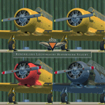
This packet includes 4 repaints of the current harvard fleet of the SKHV/KluHV
(Koninklijke Luchtmacht Historische Vlucht aka Royal Netherlands Air Force
Historical Flight). Stationed at Gilze Rijen Airbase in the Netherlands.
Featuring the PH-IIB (B-118), PH-LSK (B-64) PH-MLM (B-71) and PH-TBR (B-182)
For more info on the RNLAF Historical Flight please pay a visit to there homepage:
https://kluhv.nl/home-eng/
First three are from the RNLAF Flight School (VVO, Voortgezette Vlieg Opleiding)
at Gilze Rijen Airbase. The last one is from the so called "BAFO Vlucht"
(Photo Flight) stationed at Deelen Airbase until 1967.
The repaints are both on the outside and inside (Virtual cockpit & pilots).
As much detail is added as possible, accurate decals/stencils, also the
bump-map was modified, some latches removed some other added, also modified
the baggage compartment to look more like a Harvard then the Texan one.
Both PH-IIB and PH-LSK are updated since their initial release.
To be used with the payware A2A Simulations T-6 TEXAN/HARVARD.
Buy it here: https://a2asimulations.com/
The A2A repaintkit was used for making this repaint.
| Filename: | SKHV_North_American_T6_TexanHarvard_Current_Fleet_.zip |
| License: | Freeware |
| Added: | 21st May 2016, 20:38:29 |
| Downloads: | 396 |
| Author: | Marcel Ritzema |
| Size: | 132.94 MB |
| Category: Flight Simulator X - AFCAD Files | |
| A redesign of RPMT - Marcos and RPMQ - Imelda Romualdez Marcos (Mati Community Airport), Philippines to aid FSEconomy users |
|
File Description:
This is a redesign of RPMT - Marcos and RPMQ - Imelda Romualdez Marcos (Mati Community Airport), Philippines. This places RPMQ in the correct location and adds a fictional RPMT. This will aid FSEconomy users where one airport (RPMT) was entirely missing. Google Maps has been used to provide the correct (as physically possible within FSX and ADE) position, size and type of runway, aprons and buildings. The immediate surrounding scenery has been included. ADE used to compile the design.
| Filename: | A_redesign_of_RPMT__Marcos_and_RPMQ__Imelda_Romual.zip |
| License: | Freeware |
| Added: | 11th October 2017, 00:59:22 |
| Downloads: | 165 |
| Author: | Matthew Ward |
| Size: | 121 KB |
| Category: Prepar3D V5 - AI Aircraft | |
| P3DV4-5 FSPX Airbus A330-200F Wizzair lsf Ministry of Foreign Affairs and Trade opf Government of Hungary |
|
Images related to this file:
File Description:
Textures only for FSPXAI AIRBUS A330-200/200F payware. Fantastic model and paint kit by Mitsushi Yukata with PBR textures. Painted by Joel Branchu for realtraffic with the registration. Nov 2022
| Filename: | P3DV45_FSPX_Airbus_A330200F_Wizzair_lsf_Ministry_o.zip |
| License: | Freeware |
| Added: | 19th November 2022, 06:10:44 |
| Downloads: | 43 |
| Author: | Joel Branchu |
| Size: | 1.23 MB |
| Category: Flight Simulator X - Flight Plans | |
| Flight plan for Cape Town FACT to Johannesburg FAOR for iFly 747-400v2 for FSX and FSX SE |
|
File Description:
This file contains information for the route for a flight between Cape Town South Africa to Johannesburg South Africa using the following airports:
Departure: Cape Town International Airport / Cape Town International Airport Kaapstad Internasionale Lughawe / Isikhululo seenqwelomoya SaseKapa
IATA: CPT
ICAO: FACT
WMO: 68816
Destination: O.R. Tambo International Airport / O.R Tambo Internasionale Lughawe
IATA:JNB
ICAO: FAOR
WMO: 68368
| Filename: | Flight_plan_for_Cape_Town_FACT__to_Johannesburg_FA.zip |
| License: | Freeware |
| Added: | 5th September 2024, 17:11:32 |
| Downloads: | 25 |
| Author: | David Long |
| Size: | 1.77 KB |
| Category: Flight Simulator X - AFCAD Files | |
| LYUZ - Ponikve airport - Uzice, Serbia |
|
File Description:
Uzice Ponikve Airport (Serbian: Aerodrom Uzice Ponikve) (IATA: UZC, ICAO: LYUZ); also known as Lepa Glava (literally: Beautiful Head) is an airport in the western part of Serbia. The airport is located at Ponikve (literally: Sinkholes) plateau: 8 km (5 mi) southwest from the Jelova Gora, 11 km (7 mi) east from the Mount Tara, 12 km (7.5 mi) northwest from the city of Uzice, 13 km (8 mi) southeast from the town of Bajina Basta, 19 km (12 mi) northeast from the popular tourist center with unique attractions of the Mokra Gora, 20 km (12.5 mi) north from the Mount Zlatibor, 20 km (12.5 mi) southwest from the town of Kosjeric, 27 km (17 mi) northwest from the town of Pozega, 32 km (20 mi) southwest from the Mountain resort Divcibare, 35 km (22 mi) northeast from the town of Visegrad in Republic of Srpska (BiH), 50 km (31 mi) northwest from the Mount Zlatar. The airport is partially reconstructed in order to become an international airport. Charts included
| Filename: | LYUZ__Ponikve_airport__Uzice_Serbia.zip |
| License: | Freeware |
| Added: | 18th August 2016, 03:56:56 |
| Downloads: | 245 |
| Author: | Danilo Jankovic |
| Size: | 3.56 MB |
| Category: Flight Simulator X - AFCAD Files | |
| Atlantic City International Airport (KACY), NJ |
|
File Description:
Located 09 miles NW of Atlantic City, New Jersey on 5000 acres of land, Atlantic City International Airport is a major airport serving the southern portion of New Jersey. It is also one of the main gateways for tourists looking to vacation in nearby Atlantic City, famous for its boardwalks and casinos. This airport has been very heavily modeled with many surrounding buildings and all aprons properly placed. Gates are all properly located and labeled according to the terminal chart (there are, however, no jetways like in the default scenery). General Aviation parking is available in its proper area � all aircraft in the parking area (middle of the tarmac) have collision disabled. If you select Military Cargo parking you will start on one of the helipads in the Coast Guard section. If you select Military Combat parking you will start next to the line of F-16s on ready-alert over on the Air National Guard tarmac. You can also start on a helipad north of the airport. This airport also features completely custom taxiway line and edge lighting. Because this airport uses ATC, it suffers the same bug as my KEWR airport, which is that you cannot receive taxi in directions from ATC � to gate, parking or fuel. Almost all arriving AI aircraft will also disappear from the taxiway after radioing in to ATC and failing to receive taxi instructions to the gate/parking. All traffic and instructions taxiing out works fine. All gate parking spaces have fuel, as well as the military parking and north helipad. GA aircraft can get fuel by taxiing over to the fuel station north of the GA tarmac. Taxiing onto a closed runway (marked with an �X�) will cause a crash. Broken-down taxiways are not good for your undercarriage!
Scenery constructed with use of satellite images/streetview/aerial photos - the author has not been there in person.
This scenery is meant to be used in conjunction with MegaScenery Earth New Jersey/Delaware 003. It is not required, but apron use is minimized to allow satellite scenery to show through as much as possible, and objects are placed based on the MSE textures - lack of it may make scenery look out of place.
| Filename: | Atlantic_City_International_Airport_KACY_NJ.zip |
| License: | Freeware |
| Added: | 1st February 2011, 10:28:53 |
| Downloads: | 1,355 |
| Author: | Drew Sikora |
| Size: | 5.12 MB |
| Category: Flight Simulator 2004 - Scenery | |
| Whati CEM3 in the Northwest Territories, Canada |
|
Images related to this file:
File Description:
Whati is a village at the southern end of Lac La Martre, a smaller lake (only by Canadian standards, at over 40 miles long) halfway between the Great Slave Lake and the Great Bear Lake and around 100 miles north of Yellowknife. The North West Company established a trading post there in 1793, and this was the centre for local trading in the area for 100 years until a post was opened by the Hudson Bay Company on the Great Slave Lake. The current population is in the region of 520. There is no graded road access and access is by boat or air. The main local economy revolves around hunting and fishing, with efforts being made to increase tourism amid the wilderness and the wildlife. The airfield is just over a mile east of the village, with a runway of around 3,400 feet of gravel aligned 09-27 as of 2010, with PAPI at both ends and lit. There are scheduled flights from Yellowknife by Air Tindi, included in the AI, and some GA. The terminal building is similar to that of Lutselk'e, but with a different colour scheme and with solar panels on the roof. It appears that they repaint the sign on the front of the building with a different wording every time; the one I have used is one of three that have existed in the last few years. The photos I had originally were taken in the winter, with snow. Seeing it in the summer I discovered that my version of the building is not at the right level above the ground by about a foot, or 30cm. I was too lazy to make it again, which was the only way to get it right and still have it throw a shadow on the ground. This scenery modifies the lake shore, corrects levels for land and lake, and adds the village and a connecting road in addition to the airport. A note here about my scenery making. There will not be many more to follow this as I am almost at the end of the photos I either took or found for scenery purposes, plus I expect to move on from FS9 at some point during next year.
| Filename: | Whati_CEM3_in_the_Northwest_Territories_Canada.zip |
| License: | Freeware, limited distribution |
| Added: | 15th December 2019, 19:18:29 |
| Downloads: | 150 |
| Author: | Roger Wensley |
| Size: | 4.25 MB |


© 2001-2026 AVSIM Online
All Rights Reserved
Privacy Policy |