
Where Flight Simulation Enthusiasts Gather from Around the World!
AVSIM Library - Search Results

| Category: Flight Simulator 2004 - Scenery | |
| Air Saguenay floatbase Lac Sebastien CTD3 in Quebec Canada |

|
Images related to this file:
File Description:
This is the first of five sceneries around Lac Saint-Jean in Quebec, Canada, to the west of the St Lawrence River and close to Bagotville air base. Air Saguenay are a mainly float plane company that operates hunting and fishing flights to company-owned outposts in northern Quebec, with a fleet of almost 30 aircraft including 11 de Havilland Otters and 14 Beavers as of the last count. Their HQ float base is on Lac Sebastien, which is 30 miles east of the far larger Lac Saint-Jean. There are screenshots of this scenery and others in the series that follow this post in the Lac Saint-Jean QC folder. This scenery includes in the AI an Air Saguenay turbine Otter on floats, which has been modified to operate as an AI floatplane with a new config file. The ai also includes other GA float planes. There are also planes listed that will be required only for the future posts in this series, and the relevant textures etc will be provided at the date of the posts. Some of the Beaver AI planes will only be available if you already have the aerosoft Beaver installed. There are HTAI planes used as AI in this series, updated by Nick Tselepides, and the float planes for this part of the series are included here, Cessna 185's.
| Filename: | Air_Saguenay_floatbase_Lac_Sebastien_CTD3_in_Quebe.zip |
| License: | Freeware, limited distribution |
| Added: | 4th November 2017, 07:15:09 |
| Downloads: | 295 |
| Author: | Roger Wensley |
| Size: | 11.79 MB |
| Category: Flight Simulator 2004 - Scenery | |
| Denver (KDEN), Colorado, Photo-Scenery |
|
Images related to this file:
File Description:
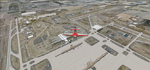
Denver (KDEN), Colorado, Photo-Scenery for FS9 & FSX.
This package covers Denver, the capital of Colorado which is also nicknamed Mile-High City because its elevation is one mile (5.280 ft). The sixth RW (16R/34L) of Denver Int'l. Airport (KDEN) is the longest commercial RW in the US with a length of 16.000ft. This allows fully loaded B747's to take off in Denvers mile-high altitude during hot summer days, when density altitudes can approach 9.000(!) ft.
KDEN is a major hub for United Airlines and the headquarters for Frontier Airlines. The airports distinctive white tent-like fabric roof is designed to be reminiscent of the snow-covered peaks of the Rocky Mountains which you can see on approach or departure.
Other important airports covered by this region are Centennial Airport (KAPA), Buckley AFB (KBKF) and Rocky Mountain Metropolitan Airport (KBJC). Extends my Mt.Evans/Georgetown package to the east and provides another 3.500 sq km in 4.7m/pix quality.
High resolution versions for FS9 and FSX (much sharper, but larger and multiple downloads) are available at www.blueskyscenery.com/GNB_SouthEast.html
. The screenies are taken from the high-res versions, so expect this version to be slightly more blurry. YourDonation@Work: Dedicated to Mark and Charles. Thanks!
| Filename: | Denver_KDEN_Colorado_PhotoScenery.zip |
| License: | Freeware, limited distribution |
| Added: | 31st October 2009, 11:24:39 |
| Downloads: | 7,292 |
| Author: | Gottfried Razek, blueskyscenery.com |
| Size: | 95.21 MB |
| Category: Flight Simulator 2004 - Scenery | |
| Steamboat Springs (KSBS), Flat Tops Wilderness Area, Colorado - Photo-Scenery |
|
Images related to this file:
File Description:
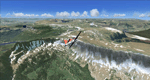
Steamboat Springs (KSBS), Flat Tops Wilderness Area, Colorado, Photo-Scenery (FS9 & FSX)
The Flat Tops Wilderness Area, which is the second largest wilderness area in Colorado, is named for its many flat topped mountains that are clearly visible from the sky. Trappers Lake, located in the north of the area inspired Arthur Carhart, a US Forest Service official, to initiate a plea for Wilderness preservation as early as 1919. Finally in 1975, three years before his death in 1978, the Flat Tops were designated a wilderness area. No wonder he found the area so entrancing: Behind Trappers Lake loom majestic volcanic cliffs, and beyond them a vast subalpine terrain reluctantly yields to alpine tundra with an average elevation of about 10.000 feet. More than 100 lakes dot the country above and below numerous flat-topped cliffs. Steamboat Springs is an internationally known winter resort destination.
To explore the scenery depart from Steamboat Springs Airport (KSBS) or Yampa Valley Airport (KHDN) and head south. High resolution versions of this scenery for FS9 and FSX (much sharper, but larger and multiple downloads) are available at www.blueskyscenery.com/GNB_West2.html . The screenies are taken from the high-res versions, so expect this version to be slightly more blurry. Thanks to Joop Mak for providing custom AFCADs that correct airport layouts so that they align with the photo-textures! They are available at www.blueskyscenery.com/AFCADs.html . YourDonation@Work: Dedicated to James.
| Filename: | Steamboat_Springs_KSBS_Flat_Tops_Wilderness_Area_C.zip |
| License: | Freeware, limited distribution |
| Added: | 26th April 2010, 17:53:25 |
| Downloads: | 1,307 |
| Author: | Gottfried Razek - blueskyscenery.com |
| Size: | 91.57 MB |
| Category: Flight Simulator X - AFCAD Files | |
| Windward Farms Airport (4NJ0), NJ |
|
File Description:
Located 02 miles NW of Rosemont, New Jersey, Windward Farms Airport is a private turf strip. Like most small private turf strips this one can prove to be slightly challenging when it comes to taking off and landing - especially in a crosswind. The runway threads between two separate stands of trees to either side, and 1/4 of the Runway 11 left side is hedged by small trees and bushes. While the published dimensions for this strip are 3500x150 feet, in reality the usable runway space is really 3000x100 feet due to vegetation. This airport as rendered in FSX does not have an actual runway surface, so when you land you will be landing on actual terrain. There isn't a noticeable slope but it can be bumpy so use caution! Edge lighting is provided for the runway, although night landings/takeoffs are not recommended. There are no services provided by this airfield. After landing why not taxi over to the hangar and feed the sheep grazing in the pasture?
Scenery constructed with use of satellite images/streetview/aerial photos - the author has not been there in person.
This scenery is meant to be used in conjunction with MegaScenery Earth New York 007. It is not required, but apron use is minimized to allow satellite scenery to show through as much as possible, and objects are placed based on the MSE textures - lack of it may make scenery look out of place.
| Filename: | Windward_Farms_Airport_4NJ0_NJ.zip |
| License: | Freeware |
| Added: | 1st February 2011, 10:29:23 |
| Downloads: | 201 |
| Author: | Drew Sikora |
| Size: | 563.16 KB |
| Category: Flight Simulator 2004 - Miscellaneous Files | |
| Active Approach - LOWI (Innsbruck, Austria) |
|
File Description:
As most know the Approach and Final (VMC) for AI Traffic in FS9 is a straight in type landing and does not always consider high terrain at airports. This is do to the way that the coding is written in FS9 and it puts limits on IFR arriving aircraft. If you open runways at certain airports the AI Traffic will fly directly through a mountain once it is established on Final for a runway. What you will see with my file is a different type approach used for the way I control AI Traffic in FS9. No longer do the AI Planes use a straight in approach when landing at LOWI. My new AI Aircraft Approach coding for FS9 now uses a base leg approach so AI Traffic does not fly through the mountains. The Innsbruck Control Tower will clear all AI Traffic (IFR FP) landing either on 08 and 26 as a straight in landing even though the offset to final is 30 degrees from the runway center line. My testing shows excellent behavior of the FS9 default models, PAI models and the Aardvark planes of all sizes to execute this new type of visual approach. Read the text file for all the default enhancements added to LOWI along with a full understanding of how the new Approaches work *** Full set of Approach Charts included plus a FS2004 Default Scenery AFCAD ***
| Filename: | Active_Approach__LOWI_Innsbruck_Austria.zip |
| License: | Freeware, limited distribution |
| Added: | 10th April 2005, 05:16:39 |
| Downloads: | 9,147 |
| Author: | Jim Vile |
| Size: | 800.49 KB |
| Category: Flight Simulator X - AFCAD Files | |
| Hackettstown Airport (N05), NJ |
|
File Description:
Located 03 miles SW of Hackettstown, New Jersey on 65 acres of land, Hackettstown Airport is a public asphalt strip 2200' in length. Fuel, tiedowns and hangars are all available for transient aircraft. For fuel, stop on the concrete pad next to the fuel tank northeast of the runway - 100LL only. Tiedowns are available both east and west of the runway - note that west parking faces the trees and if you start in one of the West Parking spots you will either need to pushback or slew to give yourself room to turn out - static aircraft collisions are off but vegetation is not. The one hangar north of the airport is open for parking, you can start there with the DOCK type parking location. This airport is not lit so daytime VFR operations only are recommended.
Scenery constructed with use of satellite images/streetview/aerial photos - the author has not been there in person.
This scenery is meant to be used in conjunction with MegaScenery Earth New York 007. It is not required, but apron use is minimized to allow satellite scenery to show through as much as possible, and objects are placed based on the MSE textures - lack of it may make scenery look out of place.
| Filename: | Hackettstown_Airport_N05_NJ.zip |
| License: | Freeware |
| Added: | 13th May 2011, 09:16:30 |
| Downloads: | 208 |
| Author: | Drew Sikora |
| Size: | 557.98 KB |
| Category: Flight Simulator X - AFCAD Files | |
| Red Lion Airport (N73), NJ |
|
File Description:
Located 02 miles S of Vincentown, New Jersey on 92 acres of land, Red Lion is a public airfield with a single asphalt runway 2880' in length. Tie downs are available at the Runway 23 end of the airport with South parking being the main tie down area. North parking is on the grass off the main taxiways and East parking is behind the main hangar near the parking lot. All parking is for aircraft with wingspans of 40' or less. Fuel is available by stopping near the tank next to the main hangar near Runway 23. PAPI for Runway 23 is out of service indefinitely, which is why you will see the PAPI boxes but no lights. All static objects and trees adjacent to the taxiways and parking spots have collision disabled.
Scenery constructed with use of satellite images/streetview/aerial photos - the author has not been there in person.
This scenery is meant to be used in conjunction with MegaScenery Earth New Jersey/Delaware 002. It is not required, but apron use is minimized to allow satellite scenery to show through as much as possible, and objects are placed based on the MSE textures - lack of it may make scenery look out of place.
| Filename: | Red_Lion_Airport_N73_NJ.zip |
| License: | Freeware |
| Added: | 9th December 2011, 14:20:51 |
| Downloads: | 171 |
| Author: | Drew Sikora |
| Size: | 1.06 MB |
| Category: Flight Simulator X - Scenery | |
| RAF Wickenby (1940s) |
|
File Description:
RAF Wickenby was a purpose built Royal Air Force station constructed late 1942 and early 1943 it had two T2 type
hangars and one B1 type. The B1 and one of the T2 hangars can still be seen on the airfield site. The T2 near the
threshold of runway 21 was recently acquired by the airfield owners and after many years of industrial use is now,
once more, an aircraft hangar.
The airfield covered about 600 acres (2.4 km2), and had the usual three runway configuration with perimeter track,
hard standings, a brick watchtower and numerous brick and metal buildings for the aircrews and ground staff. A number
of the buildings were to the east (Communal Site, Living Quarters, WAAF Quarters) and stretched to and beyond the
Lissington road - a road travelled many an evening by the airmen and women who visited their favourite watering hole,
the White Hart at Lissington. The Sick Quarters were to the south of the airfield together with a Communal Site and
Living Quarters.
The north part of the former airfield is now known as Wickenby Aerodrome, which is a grass and concrete airfield. A
road from Holton cum Beckering to Snelland runs right over the former airfield. Companies based at the airfield are
Thruster Aircraft who make microlight planes; Fly365 Ltd who fly pleasure flights; and Rase Distribution - a haulage
firm. Planes using the airfield have to make contact first with the control tower at RAF Waddington.
The Watch Office is the home of the RAF Wickenby Memorial Collection and the Wickenby Archive, a museum and collection
of memorabilia and archive dedicated to the memory of the Squadrons who served here.
| Filename: | RAF_Wickenby_1940s.zip |
| License: | Freeware |
| Added: | 10th March 2017, 14:46:25 |
| Downloads: | 136 |
| Author: | Terry Boissel |
| Size: | 15.14 KB |
| Category: Flight Simulator 2004 - Scenery | |
| Frozen Canadian & USA Rivers & Lakes Revision |
|
Images related to this file:
File Description:
This "freezes" all lakes and rivers for winter flying and means they can be landed on with skis or wheels; it is meant for low level flying rather than high level jet flights. This edition is complete in itself and now really covers all of Canada and parts of the USA along the border, including large parts of Michigan, Wisconsin, Minnesota, North Dakota, and Montana. It is reversible with an "untick" in the FS scenery library. The revision is the addition of frozen sea in the area of Baffin Island (where I and Sid & Pete have recently posted all of the Baffin Island airfields) as I missed this area last time. Sorry about that. I have spent some time making sure that the sea and the inlets along the coast in the south do not get frozen too, and also some of the lakes that are close to the coast and rarely get cold enough to freeze over. The Great Lakes do not usually totally freeze, but this is an either ON or OFF modification and partial freezing cannot be convincingly simulated, so I went for total ice. Along the north shore I went for the peak of the winter with sea ice all the way to the permanent polar cap; this is not totally realistic as there is usually a partially open lead along the coast, but as with the Great Lakes...... It will work without Ultimate Terrain, but as UT is what gets all the lakes and rivers there and in the right place (except in the far north) it is obviously much improved with UT. The pics show Rockcliffe in the winter with the frozen Ottawa River for real and in FS for comparison; without UT the river would not be in the right place.
| Filename: | Frozen_Canadian__USA_Rivers__Lakes_Revision.zip |
| License: | Freeware, limited distribution |
| Added: | 6th September 2011, 00:42:43 |
| Downloads: | 623 |
| Author: | Roger Wensley |
| Size: | 1.2 MB |
| Category: Flight Simulator 2004 - Original Aircraft | |
| AVSIM Convention A380 Aircraft |
|
File Description:
This Aircraft and Texture package was created specifically for AVSIM to represent an AVSIM Convention Mascot for the AVSIM worldwide conventions on behalf of Flight Simulation.
Transload Virtual Airlines CEO Ken Paulick was the instigator and sponsor for this texture set and release - be sure to visit one of the best VA's on the net: http://www.transloadairlines.com
| Filename: | AVSIM_Convention_A380_Aircraft.zip |
| License: | Freeware |
| Added: | 9th July 2006, 16:29:49 |
| Downloads: | 4,056 |
| Author: | Mike Stone, Aircraft and Garry J. Smith, Textures |
| Size: | 2.21 MB |


© 2001-2026 AVSIM Online
All Rights Reserved
Privacy Policy |