
Where Flight Simulation Enthusiasts Gather from Around the World!
AVSIM Library - Search Results

| Category: Flight Simulator 2004 - Scenery Design | |
| TDFCalc2004 (Version 3) |

|
File Description:
This package is for FS2004 and FS2002 terrain designers. TDFCalc2004 is made for use with FSUIPC and FS2004. This is a version that includes true heading readings, and LOD8 Zone coordinates for VTP2 lines and polys. It is an FSUIPC registered freeware program that requires version 3.? of FSUIPC.dll installed to the FS2004 Module folder. FSUIPC is avaliable on the internet, and this program requires an application registration entered within FSUIPC. Usage with FS2002 or CFS2 requires no registration with the older versions of FSUIPC. LandCalc and TDFCalc2 are small programs which require the input of Latitude and Longitude, in 'DD:MM.decimal' format. Landcalc returns the names of the "CUSTOM" textures required by photoreal ( CUSTOM ) BGLs, and LandClass BGLs ( using values #253 or #252 ). TDFCalc2 returns valuable information concerning the X, Y coordinates needed for the creation of LWM and VTP polygons/lines. TMFViewerCalc requires input as Decimal Degrees.
| Filename: | TDFCalc2004_Version_3.zip |
| License: | Freeware |
| Added: | 5th October 2003, 18:48:15 |
| Downloads: | 1,324 |
| Author: | Richard Ludowise |
| Size: | 926.55 KB |
| Category: Prepar3D V1-4 - Scenery | |
| LOGO-Airport |
|
Images related to this file:
File Description:
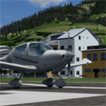
The Civil Aerodrome LOGO is located in Niederöblarn, about 30 kilometers
east of Schladming, Styria. Since 2001, there is also a heliport located on the site of the airport (ICAO code:
LOGC). It is base to the crew of the Christophorus 14 rescue helicopter.
This airfield is transfered, with kind permission from Mr. Gerhard Scholz, from his x-plane Version with ADE.
have a look on his homepage http://www.x-plane.at.
| Filename: | LOGOAirport.zip |
| License: | Freeware |
| Added: | 4th October 2017, 03:30:27 |
| Downloads: | 229 |
| Author: | Karl Malle |
| Size: | 16.01 MB |
| Category: Prepar3D V1-4 - Aircraft Repaints, Textures and Modifications | |
| Royal Australian Air Force Falcon A26-076 |
|
Images related to this file:
File Description:

Textures for the Carenado FA50 depicting RAAF Falcon A26-076.
Previously F-WWFE & N454FJ. Delivered to RAAF 09/11/1989. East Sale Airshow 1996. Avalon Airshow 2001. Served with 34 Sqn 1989 to 2002.
12/07/2002 registered VH-WIZ to Westpac Bank, Departed for Springfield, Illinois USA. 17/07/2002 registered N106BK. 10/05/2005 registered N54Sk to Dunmore Homes,25/04/2007 registered HZ-DME to Sheikh Mustafa M A Idrees (Saudi Arabia)
| Filename: | Royal_Australian_Air_Force_Falcon_A26076.zip |
| License: | Freeware |
| Added: | 10th January 2019, 18:36:38 |
| Downloads: | 200 |
| Author: | Matthew Levi |
| Size: | 34.51 MB |
| Category: Flight Simulator X - Aircraft Repaints, Textures and Modifications | |
| P-47D 57th FG/ 65th FS #40 "Hun Hunter XIV" |
|
File Description:
This folder contains a repaint for the A2A Wings of Power III P-47D Thunderbolt, representing P-47D-23-RA 42-27910 #40 "Hun Hunter XIV", as flown by Lt.Col Gilbert O. Wynand Jr, the CO of the 65th FS/ 57th FG, based in Alto, Corsica. He was more or less responsible for converting the P-47 from a high-altitude fighter to a very efficient ground attack aircraft, which was used to great effect during operation Strangle, where the German supply lines in Italy were completly cut off by destroying all railways, bridges and roads leading to the front in middle Italy. More on this can be found here: http://www.57thfightergroup.org/personal_stories/hahn/index.html
Repaint by Jan Kees Blom, based on the paintkit by Martin Catney
| Filename: | P47D_57th_FG_65th_FS_40_Hun_Hunter_XIV.zip |
| License: | Freeware |
| Added: | 14th March 2009, 10:56:15 |
| Downloads: | 569 |
| Author: | Jan Kees Blom |
| Size: | 9.12 MB |
| Category: Flight Simulator X - Scenery | |
| The Hawaiian Islands - Kauai, Part 1 of 5 |
|
File Description:
The complete scenery package is 446MB in size. In order to accommodate AvSim's file size requirement, this scenery has been broken into five smaller files. However, all five files -- Hawaii-Kauai-RS-01.zip through Hawaii-Kauai-RS-05.zip -- are necessary for this scenery to work properly. My apologies in advance for the added complexity this involves. "Hawaii-Kauai-RS-01" includes a ReadMe with detailed instructions on how to install this scenery.
Kauai itself is the fourth largest of the main Hawaiian Islands. Also known as the "Garden Isle" due to it's lush tropical foliage, it is located about 105 miles (170 kilometers) west of Oahu and just to the east of tiny Niihau. The east side of Mount Wai'ale'ale is considered to be one of the wettest spots on earth receiving an average annual rainfall of 460 inches (1,200 cm). All that water has carved out deep valleys in the central mountains, the most scenic of which is Waimea Canyon, often referred to as "The Grand Canyon of the Pacific". From shoreline cliffs to mountainous heights, to pristine beaches, enjoy exploring this picture postcard perfect landscape.
| Filename: | The_Hawaiian_Islands__Kauai_Part_1_of_5.zip |
| License: | Freeware |
| Added: | 13th July 2010, 17:03:20 |
| Downloads: | 6,112 |
| Author: | Rich Sorochak |
| Size: | 88.18 MB |
| Category: Flight Simulator X - Flight Plans | |
| Flight Plan for OB-10 Hawthorne Nevada |
|
Images related to this file:
File Description:
FSX Flight Plan for OB-10 Hawthorne Nevada IFR high speed low altitude military training route. This is the Eighth in a series of flight plans I will be uploading in the near future. This route goes through both mountainous and flat and rolling terrain in California, and Nevada. These are great routes for B-52, F-111, B-1B, B-2 A6, A4, Vulcan and any fighter or bomber enthusiasts. Of course you can fly the route with any aircraft of your choice. Included in this package are two spectacular gauges by Karol Chlebowski for TFR flying and Pave Tack which includes many advanced features for bombing, navigation and reconnaissance. These two gauges will greatly enhance your ability to fly these challenging routes and are a great companion of the flight plans. Another option to download Version 2.1 of my mini panel which has all this functionality and more.
| Filename: | Flight_Plan_for_OB10_Hawthorne_Nevada.zip |
| License: | Freeware |
| Added: | 10th July 2011, 09:48:39 |
| Downloads: | 245 |
| Author: | Bill McClellan |
| Size: | 935.5 KB |
| Category: Flight Simulator X - Flight Plans | |
| Flight Plan for OB-9 Bayshore Michigan |
|
Images related to this file:
File Description:
FSX Flight Plan for OB-9 Bayshore Michigan IFR high speed low altitude military training route. This is the ninth in a series of flight plans I have uploaded. This route goes through flat and rolling terrain and over water in Ontario and Michigan. These are great routes for B-52, F-111, B-1B, B-2 A6, A4, Vulcan and any fighter or bomber enthusiasts. Of course you can fly the route with any aircraft of your choice. Included in this package are two spectacular gauges by Karol Chlebowski for TFR flying and Pave Tack which includes many advanced features for bombing, navigation and reconnaissance. These two gauges will greatly enhance your ability to fly these challenging routes and are a great companion of the flight plans. Another option to download Version 2.1 of my mini panel which has all this functionality and more.
| Filename: | Flight_Plan_for_OB9_Bayshore_Michigan.zip |
| License: | Freeware, limited distribution |
| Added: | 10th July 2011, 09:51:28 |
| Downloads: | 201 |
| Author: | Bill McClellan |
| Size: | 942.34 KB |
| Category: Flight Simulator X - Scenery | |
| FIMP - Sir Seewoosagur Ramgoolam Intl - Mauritius *New Terminal & Airport Layout* |
|
Images related to this file:
File Description:

This scenery adds the new terminal and taxiways, and rebuilds the aprons and runway to provide a fully functioning AI traffic extension for runway 14. The airport is assigned a mean elevation, allowing it to blend naturally with the surrounding terrain, and landclass is provided for the entire island. This scenery is most effective when used in combination with "mauritius_fsx.zip" by Max Kraus. This scenery is optimized to fit seamlessly with FTX Global/Vector and should also be fully functional in all FSX configurations. The airport is updated to reflect current satellite imagery and positioning. Scenery was created using Airport Design Editor X v1.61.5298, SBuilderX 3.13, and the FSX Object Placement Tool. Scenery objects were added and modified from stock FSX scenery to resemble as closely as possible the actual airport. The FSX apron lights included are from the set created by Jim Dhaenens.
| Filename: | FIMP__Sir_Seewoosagur_Ramgoolam_Intl__Mauritius_Ne.zip |
| License: | Freeware |
| Added: | 10th July 2015, 16:16:40 |
| Downloads: | 8,810 |
| Author: | Carlyle Sharpe |
| Size: | 5.06 MB |
| Category: Flight Simulator 2004 - Scenery | |
| Bari Palese Macchie 2011 (LIBD) - Airport scenery |
|
Images related to this file:
File Description:
This FS2004 scenery reproduce the international airport "Bari Palese Macchie" (Icao: LIBD) located in the south-east region of Italy named "Puglia", 10 km north of the city Bari.
The greatest part of the airport buildings and the ground fleet vehicle are designed with photoreal textures after watching a lot of airport pictures;hundred of object, markings, static and some dynamic vehicle are placed on the scenery; the buildings, gates number and Afcad file are the same as the real airport at spring 2011. Frame rate friendly (all object designed with GMax and LOD technique) and full night lighting. Extensive handbook and set-up procedures in English and Italian language.The scenery is full compatible with photoreal background and UTE because every object is placed in the right position in according to the satellite image.
| Filename: | Bari_Palese_Macchie_2011_LIBD__Airport_scenery.zip |
| License: | Freeware |
| Added: | 11th October 2011, 04:02:13 |
| Downloads: | 9,744 |
| Author: | Alberto Di Bolzano/AlbySim Scenery Design |
| Size: | 26.42 MB |
| Category: Flight Simulator X - Scenery | |
| Mayaguana (MYMM) - The Bahamas |
|
Images related to this file:
File Description:
Mayaguana is the easternmost island in the Bahamas with Bahamasair providing Nassau and Inagua air connections. The airport utilizes part of an abandoned 11,000 foot USAF runway. The runway is listed as 7300 foot long, but 2400 feet on the east end is closed indefinitely. A new terminal building was completed, but no apron or taxiway connects it to the runway so it is unoccupied. Construction was started on another terminal, apron and taxiway as well as runway repaving, but the project is currently abandoned. All of the aforegoing is represented by this scenery. The scenery includes custom scenery objects; placement of library objects and landclass changes. Scenery is based on Bing Maps and photos taken locally, and it is optimized for use with UTX-TAC.
| Filename: | Mayaguana_MYMM__The_Bahamas.zip |
| License: | Freeware |
| Added: | 20th April 2013, 20:18:45 |
| Downloads: | 1,127 |
| Author: | Art Poole |
| Size: | 1.04 MB |


© 2001-2026 AVSIM Online
All Rights Reserved
Privacy Policy |