
Where Flight Simulation Enthusiasts Gather from Around the World!
AVSIM Library - Search Results

| Category: Flight Simulator 2004 - Flight Plans | |
| Qantas Empire Airways - Sydney to Hong Kong - 1949 |

|
File Description:
Desiring to expand air links with the Far East, Qantas Empire Airways (QEA) conducted a successful proving flight to Hong Kong in March 1949. Regular services commenced on the 26th of June 1949, utilising Douglas DC-4 aircraft that QANTAS had purchased from British Commonwealth Pacific Airlines (BCPA) when that airline took delivery of their new DC-6’s. Route was Sydney - Darwin - Labuan (Borneo) - Hong Kong. Please take time to read the included Word.doc file which provides additional information about the flight. This recreation uses Jens Kristensen’s DC-4 and Wayne Tudor’s QEA livery.
| Filename: | Qantas_Empire_Airways__Sydney_to_Hong_Kong__1949.zip |
| License: | Freeware |
| Added: | 9th September 2006, 12:25:10 |
| Downloads: | 524 |
| Author: | Bruce Kennewell |
| Size: | 235.28 KB |
| Category: Flight Simulator X - Scenery | |
| The Raptors Roost Lodge, Reef Lake, Canada |
|
File Description:
This scenery is located East of Ketchikan up near Stewart in Canada at a lake named Reef Lake. It has a water runway but you can use the beach in a pinch. There is not much room to maneuver so it may be a good idea to start here so you will know what to expect. This is not your mothers scenery. If when Holger comes out with his scenery for this area and there are conflicts I will repair it to work with that. This scenery has sounds.
| Filename: | The_Raptors_Roost_Lodge_Reef_Lake_Canada.zip |
| License: | Freeware, limited distribution |
| Added: | 7th July 2008, 13:08:30 |
| Downloads: | 1,193 |
| Author: | Joe Watson / Raptor X Sceneries |
| Size: | 1.33 MB |
| Category: Flight Simulator X - Scenery | |
| YMWA Mullewa, Western Australia |
|
File Description:
YMWA Mullewa Airstrip, like many strips in WA is merely a dirt scrape alongside the road. Mullewa is a town in the Mid West region of Western Australia, 450 kilometres (280 mi) north of Perth and 98 kilometres (61 mi) east northeast of Geraldton. Operator - Mullewa Shire Council, PO Box 166, Mullewa, WA, 6630. PH 08 9961 1007, PH AH 9961 1180: 9961 1118, FAX 9961 1206. REQUIRES Blencowe_LibraryKit.zip
REQUIRES blencowe_librarykit_309494.zip (Available HERE)
| Filename: | YMWA_Mullewa_Western_Australia.zip |
| License: | Freeware |
| Added: | 28th February 2013, 13:58:23 |
| Downloads: | 222 |
| Author: | Alan Blencowe |
| Size: | 1.62 MB |
| Category: Flight Simulator X - Scenery | |
| KTEX - Telluride Regional Airport - Colorado, USA |
|
Images related to this file:
File Description:
East Coast Simulations presents scenery for Telluride Regional Airport (KTEX/TEX) for FSX/P3D! Telluride Regional Airport (IATA: TEX, ICAO: KTEX, FAA LID: TEX) is a public airport six miles west of Telluride, in San Miguel County, Colorado. It is owned by the Telluride Regional Airport Authority. At an elevation of 9,078 feet (2767 m) above sea level, it was the highest commercial airport in North America with scheduled passenger flights, until Great Lakes Airlines ended service in 2014. This scenery includes all custom buildings and terminals with a season changing photoreal background.
| Filename: | KTEX__Telluride_Regional_Airport__Colorado_USA.zip |
| License: | Freeware |
| Added: | 30th June 2015, 23:47:41 |
| Downloads: | 1,699 |
| Author: | Wesley Chin and Kyle Kato |
| Size: | 92.55 MB |
| Category: Prepar3D V1-4 - Aircraft Repaints, Textures and Modifications | |
| Supermarine Spitfire Mk.IX (MH538) YT-Jas |
|
Images related to this file:
File Description:
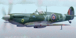
This folder contains a repaint for the Spitfire Mk.IX by Real Air, in the colors of Spitfire Mk.IX MH538 of No.65 (East India) Sqn, based in Kingsnorth in june 1943. This was the aircraft of Squadron Leader James E. Storrar, an ace with 15 victories by the end of the war. He was promoted to Wing Commander in 1944 at the age of 23 and commanded three squadrons of Mustangs till the end of the war. Repaint by Jan Kees Blom, based on the paintkit by RealAir.
| Filename: | Supermarine_Spitfire_MkIX_MH538_YTJas.zip |
| License: | Freeware |
| Added: | 6th January 2019, 17:34:27 |
| Downloads: | 57 |
| Author: | Jan Kees Blom |
| Size: | 4.74 MB |
| Category: Flight Simulator X - Aircraft Repaints, Textures and Modifications | |
| FSX/P3D TAI DC-8-33 1962 |
|
Images related to this file:
File Description:
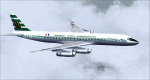
This is a repaint of a DC-8-33 in TAI (Transports Aeriens Intercontinentaux) colors. The payware DC-8 10-40 pack by JustFlight is needed for this repaint. TAI purchased its first jetliner in 1960 - the DC-8-33. They received 3 in total before the merger with UAT. F-BJUV was purchased in 1961. The DC-8s were used on TAI's longest routes to the Far East, the Pacific, and Australasia. This repaint was tested on FSX-SE. It should work on FSX & P3D v1-3. Textures are DXT5 dds.
| Filename: | FSXP3D_TAI_DC833_1962.zip |
| License: | Freeware |
| Added: | 19th March 2019, 17:02:06 |
| Downloads: | 77 |
| Author: | Ted Giana |
| Size: | 10.89 MB |
| Category: Flight Simulator X - Aircraft Repaints, Textures and Modifications | |
| Korean Air Cargo Boeing 747-8B5F (HL7624) |
|
Images related to this file:
File Description:
Korean Air Cargo is ranked 5th in the world for largest cargo operations. Transporting over 7,666 million freight tonnes
around the world, the airline has established a dominant position as a primary cargo carrier in the East Asian region.
In order to sustain operations, the airline looked to the new and improved 747-8F to continue their flagship cargo
service. Here is my representation of the beautiful Korean Air Cargo livery on the 747-8F. I researched the aircraft
before painting to ensure I pick up as many details as I can. Enjoy!
| Filename: | Korean_Air_Cargo_Boeing_7478B5F_HL7624.zip |
| License: | Freeware, limited distribution |
| Added: | 23rd June 2015, 17:35:00 |
| Downloads: | 384 |
| Author: | Rohan Patel |
| Size: | 12.34 MB |
| Category: Flight Simulator 2002 - Scenery | |
| Big Cypress Swamp Airstrips |
|
File Description:
A package of 3 'bush-style' airstrips set in Big Cypress National Preserve, Florida - something of a rare destination for most FS2002 bush pilots! They're not to
be confused with the nearby 5600ft paved runway owned by the Seminole Indian tribe: these are all just very rudimentary dirt or grass strips in the middle of a
swamp. The airstrips do exist in reality, however based on recent satellite imagery I think they're now disused. A second cluster of Big Cypress airstrips can be found further south (across Alligator Alley) although these being very slightly more developed are part of the default FS2002 scenery library.
| Filename: | Big_Cypress_Swamp_Airstrips.zip |
| License: | Freeware, limited distribution |
| Added: | 28th May 2003, 21:32:27 |
| Downloads: | 681 |
| Author: | James Belk |
| Size: | 2.24 MB |
| Category: Flight Simulator 2004 - Scenery | |
| Zion National Park North, Cedar Breaks National Monument, Cedar City (KCDC), Utah, Photo-Scenery (FS9 & FSX) |
|
Images related to this file:
File Description:
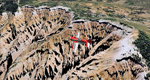
Cedar Breaks National Monument is a large amphitheater cliff in bright colors of red, orange and purple.
It lies east of Cedar City in the northern region of the scenery. The cliff was formed by erosion thru wind,
water and ice. Today erosion continues with a pace of about 2 inches every 5 years. Although it is called
Cedar Breaks, there are no cedars growing there but juniper trees. For a scenic flight to Cedar Breaks
National Monument best depart from Cedar City Regional Airport (KCDC) and head east. The scenery extends
south to Zion National Park and covers a large part of Zion Canyon and the Kolob Canyons area.
Zion National Park is another place where erosion of the Colorado Plateau formed the most beautiful colorful
stone formations of unique and wonderful shapes. There are nine different layers of stone visible in the park.
Most of them consist of sandstone. But there is also limestone, gypsum, siltstone, shale, clay and mudstone.
The Virgin River cut a spectacular and famous canyon thru Zion Park that is as narrow as 20ft and up to 2000ft tall.
High resolution versions of this scenery for FS9 and FSX (much sharper, but larger and multiple downloads)
are available at www.blueskyscenery.com/CNY_South2West5.html . The screenies are taken from the high-res versions,
so expect this version to be slightly more blurry.
Thanks to Joop Mak for providing a custom AFCADs that correct airport layouts so that they align with the photo-textures!
They are available here: www.blueskyscenery.com/AFCADs.html . YourDonation@Work: Dedicated to Richard, P.J. and Felix.
| Filename: | Zion_National_Park_North_Cedar_Breaks_National_Mon.zip |
| License: | Freeware, limited distribution |
| Added: | 14th March 2010, 00:30:28 |
| Downloads: | 1,566 |
| Author: | Gottfried Razek - blueskyscenery.com |
| Size: | 97.13 MB |
| Category: Flight Simulator 2004 - Flight Plans | |
| Hopping Round The World Adventure - Pack 22 |
|
File Description:
Who said anything about AI planes doing touch and go in FS2004. Cool effect Microsoft! The only newbie to this pack is the MelJet Boeing 747F. The Northern Lights also known as the Aurora Borealis dances across the sky for your pleasure. Hope you find time to enjoy the light show and howl at the full moon also. CFIT – Controlled Flight Into Terrain. This is how real-world pilots meet their end. Don’t let it happen to you. At this time of year the sun hardly makes it past the horizon any time of day. Another zero visibility landing with an unusual request from ATC. Who said IFR was easy? Not me!!
| Filename: | Hopping_Round_The_World_Adventure__Pack_22.zip |
| License: | Freeware |
| Added: | 26th December 2003, 17:37:00 |
| Downloads: | 3,040 |
| Author: | David Dossiere |
| Size: | 2.06 MB |


© 2001-2026 AVSIM Online
All Rights Reserved
Privacy Policy |