
Where Flight Simulation Enthusiasts Gather from Around the World!
AVSIM Library - Search Results

| Category: Flight Simulator 2002 - Scenery | |
| Bristol International Airport |

|
File Description:
Detailed scenery of Bristol International Airport (UK EGGD BRS) for FS2002. Includes its own elevated mesh terrain, specially designed buildings and airport objects and even the distinctive ILS LOC transmitters on Runway 09. By Shaun Manners. Requires Trees Library by Gerrish Gray.
| Filename: | Bristol_International_Airport.zip |
| License: | Freeware |
| Added: | 3rd December 2003, 00:34:18 |
| Downloads: | 2,029 |
| Author: | Shaun Manners |
| Size: | 1.87 MB |
| Category: Flight Simulator 2004 - Scenery | |
| Spain & Portugal Mesh 2004 |
|
File Description:
This scenery cover entire Spain, Portugal and south France till E005. This scenery is compatible with my Italian mesh 2004 scenery.
Based on SRTM 3 arc.sec data.
Unfortunately SRTM DATA have many holes and data loss, so I made a resampling and an oversampling with other data with lower resolution, but with better coverege with geo cad software like Grass and GlobalMapper for projection convertion.
Compression and conversion to bgl with MS Flight simulator SDK at LOD 9
| Filename: | Spain__Portugal_Mesh_2004.zip |
| License: | Freeware |
| Added: | 17th November 2003, 17:04:23 |
| Downloads: | 34,290 |
| Author: | Pietro Mauri |
| Size: | 92.79 MB |
| Category: Flight Simulator 2004 - Scenery | |
| RANGITAIKI - NZRK |
|
Images related to this file:
File Description:
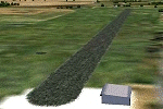
Simple rendition of this aerodrome, 16nm south-east of Taupo, (NAZP), New Zealand. Made for Christian Stock's NZ mesh in the form of "Mountains of New Zealand"
and topo in the form of "Lakes and Rivers of New Zealand".
| Filename: | RANGITAIKI__NZRK.zip |
| License: | Freeware |
| Added: | 6th February 2011, 03:46:28 |
| Downloads: | 207 |
| Author: | Godfrey Tier |
| Size: | 183.53 KB |
| Category: Flight Simulator 2004 - Scenery | |
| Himalayan Peaks Volume 2 - Mt. Everest photoreal textures |
|
File Description:
The photoreal textures in this package cover an area of about 100km (E/W) by 60km (N/S) featuring Mt. Everest and several neighboring peaks and are based on a Landsat 7 ETM 15-m multispectral image taken in October 2000. The relatively low resolution of the image makes for pretty grainy textures up close and I did not add any autogen, seasonal textures, or flattened water bodies. Nevertheless, I do believe the photoreal textures do a much better job at showing the grandiose alpine features of this area - rock faces, snow fields, glaciers, and bare ground - than generic landclass textures possibly can. The textures are placed for a best fit with our Mt. Everest area LOD10 terrain mesh, fs_him_01.zip, but probably work OK with the default LOD8 mesh of this area or third-party terrain mesh files.
| Filename: | Himalayan_Peaks_Volume_2__Mt_Everest_photoreal_tex.zip |
| License: | Freeware |
| Added: | 10th March 2010, 22:27:43 |
| Downloads: | 25,492 |
| Author: | Holger Sandmann |
| Size: | 75.71 MB |
| Category: Flight Simulator X - Scenery | |
| Cushman Air Park (WACP) |
|
File Description:
This is a new “fictitious" Air Park in the State of Washington designed specifically for FSX. It serves as the Fire Base Air operations in the Pacific North West. Designed for use with Ultimate Terrain X (UTX-USA), Mesh Resolution set to 10m, and Mesh Complexity set to 80.
Some older (FS9) object libraries have been used but are not required(see the readme). Includes AI and a special Fire Spotter repaint of the default Cessna 208B.
| Filename: | Cushman_Air_Park_WACP.zip |
| License: | Freeware, limited distribution |
| Added: | 14th September 2007, 18:24:31 |
| Downloads: | 1,200 |
| Author: | Bill Dick and Phil Cayton |
| Size: | 527.58 KB |
| Category: Flight Simulator 2002 - Scenery | |
| Pirinees - Escenario Mesh De Los Pirineos |
|
File Description:
This MESH scenery is the PIRINEES. The long goes from 1º52´27,725´´ WEST, to 3º11´55,022´´ EAST. In that scenery the problem of the Greenwich meridian has gone.Este escenario es de todos los PIRINEOS.es un escenario MESH de elevaciones. La longitud del escenario va desde los 1º52´27,725´´ OESTE, hasta los 3º11´55,022´´ ESTE. Es este escenario he conseguido eludir el problema del meridiano de Greenwich.
| Filename: | Pirinees__Escenario_Mesh_De_Los_Pirineos.zip |
| License: | Freeware |
| Added: | 2nd May 2003, 22:48:43 |
| Downloads: | 1,552 |
| Author: | Julio Estefanía Estefania |
| Size: | 8.3 MB |
| Category: Flight Simulator 2004 - Scenery | |
| Spokane River Area for Ultimate Terrain |
|
File Description:
Spokane River Area for Ultimate Terrain - scenery & effects
for the Spokane River area from Cougar Bay in Couer d'Alene, ID to Long Lake, WA.
Includes most major bridges (road & rail), 5 dams & power houses, river scenery and effects.
All scenery is placed to correspond with Google Earth and Ultimate Terrain.
Designed in GMAX for use with Ultimate Terrain USA and 38m mesh.
DXT1 textures. For Flight Simulator 2004 (FS9) ONLY.
| Filename: | Spokane_River_Area_for_Ultimate_Terrain.zip |
| License: | Freeware |
| Added: | 29th September 2005, 01:18:16 |
| Downloads: | 1,264 |
| Author: | Lou Frost |
| Size: | 1.99 MB |
| Category: Flight Simulator 2004 - Scenery | |
| Balclutha Aerodrome - NZBA |
|
Images related to this file:
File Description:
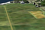
26nm south-east of Dunedin, New Zealand. The aerodrome is popular with model aircraft enthusiasts. Made for Christian Stock's NZ mesh in the form of "Mountains of New Zealand" and topo in the form of "Lakes and Rivers of New Zealand".
| Filename: | Balclutha_Aerodrome__NZBA.zip |
| License: | Freeware |
| Added: | 9th January 2011, 03:55:35 |
| Downloads: | 395 |
| Author: | Godfrey Tier |
| Size: | 2.42 MB |
| Category: Flight Simulator 2004 - Scenery | |
| Murchison Aerodrome - NZMR |
|
Images related to this file:
File Description:

34nm east of Westport, New Zealand. $5 landing fee. Please place in honesty box. Made for Christian Stock's NZ mesh in the form of "Mountains of New Zealand" and topo in the form of "Lakes and Rivers of New Zealand".
| Filename: | Murchison_Aerodrome__NZMR.zip |
| License: | Freeware |
| Added: | 13th January 2011, 22:25:05 |
| Downloads: | 253 |
| Author: | Godfrey Tier |
| Size: | 118.85 KB |
| Category: Flight Simulator 2004 - AFCAD Files | |
| Sucre SLSU Bolivia |
|
Images related to this file:
File Description:
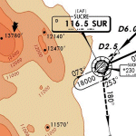
AFCAD file for FS2004 default scenery of Sucre SLSU Juanna A. De Padilla airport in Bolivia.
Brings runway to proper dimensions and adds approach (PAPI) lighting as in the real airport.
High elevation airport (9430 ft.) with surrounding terrain of the Bolivian Andes.
There is no night lighting at this airport. Approach charts included. Recommended mesh terrain: mesh_fermandois003_265585.zip
| Filename: | Sucre_SLSU_Bolivia.zip |
| License: | Freeware, limited distribution |
| Added: | 19th March 2010, 08:55:01 |
| Downloads: | 562 |
| Author: | Kyprianos Biris |
| Size: | 683.9 KB |


© 2001-2026 AVSIM Online
All Rights Reserved
Privacy Policy |