
Where Flight Simulation Enthusiasts Gather from Around the World!
AVSIM Library - Search Results

| Category: Flight Simulator X - Scenery | |
| Ranger 6000FT. Base camp scenary |

|
File Description:
This Scenary is good for resupply training missions with Helos.
This is for the Ranger 6000ft.Training camp, The airport name is Ranger 6000ft.training camp.(SRTC) The NDB(none directional beacon) frequency is 217.0,
NDB Range is 100 NM. Camp is 65 NM. East of Port Hardy British Columbia-CYZT. Or 164 NM. North-West of Vancouver Intl. British Colimbia-CYVR.
| Filename: | Ranger_6000FT_Base_camp_scenary.zip |
| License: | Freeware |
| Added: | 5th July 2008, 00:22:33 |
| Downloads: | 248 |
| Author: | Timothy T. Marson |
| Size: | 3.18 KB |
| Category: Flight Simulator X - Scenery | |
| Ranger 6000FT. base camp scenary |
|
File Description:
This Scenary is good for resupply training missions with Helos.
This is for the Ranger 6000ft.Training camp, The airport name is Ranger 6000ft.training camp.(SRTC) The NDB(none directional beacon) frequency is 217.0,
NDB Range is 100 NM. Camp is 65 NM. East of Port Hardy British Columbia-CYZT. Or 164 NM. North-West of Vancouver Intl. British Colimbia-CYVR.
| Filename: | Ranger_6000FT_base_camp_scenary.zip |
| License: | Freeware |
| Added: | 5th July 2008, 00:24:59 |
| Downloads: | 276 |
| Author: | [email protected] |
| Size: | 3.21 KB |
| Category: Flight Simulator 2004 - Aircraft Repaints, Textures and Modifications | |
| B-25N Mitchell, SKHV, 320 Sqn NEI, "Sarinah" |
|
Images related to this file:
File Description:
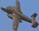
This packet contains a repaint in the livery of the B-25N Mitchell currently flown by the SKHV (Royal Netherlands Air Force Historical Flight Foundation). Registration N320SQ, "Sarinah", in the scheme of the NEI (Netherlands East Indies Airforce) as flown from Australia in the second world war. Texture only, to be used with the payware B-25 from http://www.maam.org/maam_sim.html
| Filename: | B25N_Mitchell_SKHV_320_Sqn_NEI_Sarinah.zip |
| License: | Freeware, limited distribution |
| Added: | 24th January 2010, 21:53:03 |
| Downloads: | 247 |
| Author: | Marcel Ritzema |
| Size: | 6.38 MB |
| Category: Flight Simulator 2004 - Sounds | |
| Real AI Jet Sounds |
|
File Description:
These sound files will enhance the feel of any airport that has AI JET traffic. They create a realistic blend of taxiing & takeoff / landing sounds whether you are in cockpit / tower or spotplane view.
The sounds were recorded at East Midlands (EGNX) airport in England & are from a boeing 737-300, but can be used for any medium or large AI traffic.
| Filename: | Real_AI_Jet_Sounds.zip |
| License: | Freeware |
| Added: | 20th February 2006, 20:38:18 |
| Downloads: | 5,038 |
| Author: | Bruce Martin |
| Size: | 274.64 KB |
| Category: Flight Simulator 2004 - Scenery | |
| BCb Short Leg's |
|
File Description:
This scenery is located in British Columbia, Canada. All default enhanced.
Airport name's, 21* East variation.
1.Tipella (CBB7) default field 2300' gravel.
2.Hope (CYHE) default field. Check down stream a bit for some buildings on the water edge I added. 3960' grass. default NDB close by on 245Khz.
3.Lytton (CYLY) default field. 2450' gravel.
| Filename: | BCb_Short_Legs.zip |
| License: | Freeware |
| Added: | 22nd September 2003, 02:32:14 |
| Downloads: | 2,191 |
| Author: | Frank Betts |
| Size: | 2.8 MB |
| Category: Flight Simulator X - Aircraft Repaints, Textures and Modifications | |
| Mikoyan-Gurevich MiG-21MF "Luftstreitkraefte der NVA" |
|
Images related to this file:
File Description:
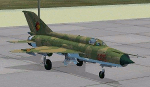
Six paint schemes used by the "LSK der NVA" (East German Air Force) for Ivan Jurcaga's MiG-21MF; one grey, five camo.
Aircraft of all six fighter squadrons of the LSK are represented, though in one case the Fishbed was actually a "M" instead of a "MF".
Requires MiG-21MF model from http://migsim.ic.cz/ .
Read the Readme for more information.
| Filename: | MikoyanGurevich_MiG21MF_Luftstreitkraefte_der_NVA.zip |
| License: | Freeware |
| Added: | 2nd August 2011, 01:03:21 |
| Downloads: | 290 |
| Author: | Bjoern Kesten, Ivan Jurcaga |
| Size: | 6.09 MB |
| Category: Flight Simulator 2004 - Scenery | |
| Canouan TVSC in the Grenadines |
|
Images related to this file:
File Description:
Canouan Island is the one of the middle islands in the chain known as St Vincent and the Grenadines, between Mustique and Union Island. Canouan is around 5 miles long and shaped like a hook, with a resident population of 1,200. There has been major touristic development on the island since the early 1990's and the island now has paved roads, electricity, and desalinated water along with a golf course.
The airport is at the southern end of the island and the runway has been extended to 5,875 feet on reclaimed land, making Canouan the jet airport for the Grenadines with flights from North and South America. There are connecting flights to the other islands by SVG and LIAT. The airport apron has been extended to accomodate larger planes and I have shown the airport with this apron work still in progress and during the expansion of the terminal building. The AI has two international flights, on Wednesday and Saturday, and both by American.
| Filename: | Canouan_TVSC_in_the_Grenadines.zip |
| License: | Freeware, limited distribution |
| Added: | 11th June 2013, 22:59:04 |
| Downloads: | 657 |
| Author: | Roger Wensley |
| Size: | 3.6 MB |
| Category: Flight Simulator 2004 - Scenery | |
| Circle Line Ferry Cruising New York Harbor |
|
Images related to this file:
File Description:
New York Harbor cruise - passing by Ellis Island, the Statue of Liberty and the Verrazano-Narrows Bridge - featuring the marvelous model of the Circle Line Ferry, created by Ron Jeffers. This package includes a custom Afcad - using the invisible runway and taxiway technique - and a flightplan which has the Ferry cruising around the harbor every 1/2 hour. Each cruise lasts approximately 30 minutes. This enhancement has been designed for use with the default FS2004 scenery. It has not been tested with Ultimate Terrain but may work in that environment if the Afcad is adjusted. Please unzip to a temporary folder and follow the simple installation instructions. Compiled for your flying enjoyment by
David "Opa" Marshall.
| Filename: | Circle_Line_Ferry_Cruising_New_York_Harbor.zip |
| License: | Freeware |
| Added: | 10th December 2009, 12:40:19 |
| Downloads: | 3,126 |
| Author: | David "Opa" Marshall |
| Size: | 330.07 KB |
| Category: Flight Simulator 2004 - AI Flight Plans | |
| Ameristar Air Cargo Summer 2010 |
|
Images related to this file:
File Description:

Ameristar Air Cargo for the week of July 25-31. Flights for 10 FA20s (repaints available for all of these), 1 DC9-15F (repaint available), 3 Learjet 25s (no repaints) and their E90 (no repaints). I've had to place positioning flights to get the aircraft back to where the week starts to make these work. These positioning flights are mostly very early Sunday morning; i.e., 1:00 AM (local) departures. Also, the positioning flight's altitudes are such that even if you are flying around in the middle of a Saturday-Sunday night, you only have a 99.99999% chance of seeing/hearing them. Flights taken from FlightAware for the week of 25-31 July, 2010.
| Filename: | Ameristar_Air_Cargo_Summer_2010.zip |
| License: | Freeware |
| Added: | 5th August 2010, 01:05:12 |
| Downloads: | 821 |
| Author: | Steve Lewis |
| Size: | 14.72 KB |
| Category: Flight Simulator 2004 - Scenery | |
| Paulatuk CYPC in the Northwest Territories, Canada |
|
Images related to this file:
File Description:
Paulatuk is on the coast of northern mainland Canada, 200 miles east of Tuktoyaktuk and 170 miles southwest of Ulukhaktok. It is just to the east of the Parry Peninsula, which has at its northern tip the Cape Parry DEW line Main Station. Paulatuk was established in the 1920's, and the population now numbers around 320. Paulatuk airfield is close to the village but on higher ground, while the village follows the curve of the coast. The 4,000 feet of 100 feet wide gravel runway is aligned 021T/201T where T stands for "true" as opposed to magnetic in the Northern Domestic Airspace. Only JETA-1 is available unless there is 100LL in drums. There are flights by Aklak Air from Inuvik, which is around 250 miles to the west; Aklak Air is actually Kenn Borek under a diferent name. The AI is for a daily passenger flight, and for a cargo flight on Wednesdays. In the summer, float planes use the lake to the south of the village, but I have no information as to docks or any other facilities; probably there aren't any.
| Filename: | Paulatuk_CYPC_in_the_Northwest_Territories_Canada.zip |
| License: | Freeware, limited distribution |
| Added: | 3rd December 2012, 21:58:47 |
| Downloads: | 278 |
| Author: | Roger Wensley |
| Size: | 4.39 MB |


© 2001-2026 AVSIM Online
All Rights Reserved
Privacy Policy |