
Where Flight Simulation Enthusiasts Gather from Around the World!
AVSIM Library - Search Results

| Category: Flight Simulator X - Aircraft Repaints, Textures and Modifications | |
| Southwest Airlines "N'Number" Boeing B737-700 and B737-800 and 2000'th 737NG |

|
Images related to this file:
File Description:
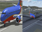
This is a pack of 10 Southwest Airlines Registrations Numbers. It has 6 -700 and 4 -800. It also includes the 2000'th 737NG delivered. These are the following registrations numbers: -700:N431WN, N432WN, N737JW, N740SW, N7740A, -800: N8601K, N8606C, N8610A, N8614M. The registrations numbers have there own custom cockpit equipment that corresponds to when they were built. I also have included my "Dirty Wing" on the older -700's and everything else has a clean wing. The bump maps are provided by Chris Hicks and go check out his paints, they are excellent. This is meant to be used with the PMDG 737NGX. The PMDG 737 NGX Base-Pack and Add-on pack are required for use. Installation with the Livery Manger.
| Filename: | Southwest_Airlines_NNumber_Boeing_B737700_and_B737.zip |
| License: | Freeware |
| Added: | 14th July 2013, 09:11:00 |
| Downloads: | 2,312 |
| Author: | Ian Besemer |
| Size: | 257.32 MB |
| Category: Flight Simulator X - Scenery | |
| 63 AI Ships and AI Ship Traffic for South America and Europe V1 |
|
Images related to this file:
File Description:

Plenty of good designers have created beautiful navy ships and aircraft carriers for FSX, but only few have created container ships, tankers, off-shore supply ships, tugs, or bulk carriers and put them to sail around the globe in FSX. With this package I intend to fill a part of this gap and to bring more life to the mostly empty oceans in FSX by providing AI ships and AI traffic files with a fleet of modern merchant ships travelling through some of the most heavily trafficked sea routes in the world. The pack contains 63 AI ships based on more than 35 different GMAX models. Around one third are equipped with landable helicopter decks. Most ships have simple animations like rotating radars and most have custom light, smoke and wake effects. The pack also contains traffic files for the east coast of South America and the coasts of North West Europe: In South America ships visit Belem, Sao Louis, Natal, Recife, Salvador, Macae, Rio de Janeiro, Santos, Florianopolis, Pelotas, Porto Alegre, Montevideo, Buenos Aires and Puerto Madryn. In Europe ships visit Gibraltar, Algeciras, Lissabon, Bordeaux, La Rochelle, Saint Nazaire, Brest, Le Havre, Antwerp, Rotterdam, Amsterdam, Thamesport, Felixstowe, Bremerhaven, Hamburg, Esbjerg, Oslo, Aarhus, Copenhagen and St.Petersburg. For map of coverage, routes and ship details see the PDF manual.
| Filename: | 63_AI_Ships_and_AI_Ship_Traffic_for_South_America_.zip |
| License: | Freeware |
| Added: | 3rd March 2013, 16:37:41 |
| Downloads: | 23,956 |
| Author: | Henrik Nielsen |
| Size: | 17.24 MB |
| Category: Flight Simulator 2004 - Scenery | |
| Cyprus: Airfields plus landmarks and land class for all of Cyprus and AI |
|
Images related to this file:
File Description:
Cyprus, an island in the eastern Mediterranean. Without the benefit of Ultimate Terrain, which does not exist for Cyprus, the land class provided by FS9 stands out as hopelessly inadequate. I have added the extensive farmland and the larger towns and villages, plus the major roads. Four completely new airfields are included here, three in the north and one in the south. Ercan LCEN is in the north and functions as the airport for all of the north. It was recently closed for two years while a new terminal was built and the runway updated and an apron extended etc, and during that time Gecitkale LCGK functioned (barely) as the airport for the north. Gecitkale is now hardly used at all. The third northern airfield is Ilker Karter LCIK and this functions as the HQ base of the Turkish Army Corp in northern Cyprus. The last of the new airfields is Kingsfield LCRE, which is in the Sovereign Base area to the east of Larnaca and is now used for recreational purposes. Ercan is now undergoing further expansion with a new runway and a new terminal building and apron, so this scenery is for the period between 2010 to 2015. My set up of Cyprus already included a payware Larnaca by Aerosoft (now only 12 euros) plus a freeware Paphos, Nicosia, and Akrotiri; that was my starting point. Larnaca has been the major airport for Cyprus since the mid 1970's, with a huge tourist trade that peaks in the summer but which is year long (almost a million Brits visit every year, let alone the other nationalities). I have adapted this (gate sizes etc) to allow parking by a multitude of B737's and others. Nicosia is freeware (posted in 2010) and I have included modifications to reflect its now total disuse. Paphos is at the far western end of the island and freeware, and I have modified this to allow larger and military ai aircraft to function properly; the poster improved his first version to better cater for ai but I was unaware of this and I have stayed with my modifications. Akrotiri is freeware and includes a lot of library object input from MAIW. I have modified the parking somewhat and added further residential areas and munitions storage. The AI is based upon recorded take offs and landings in April, with some further additions in later months. At Ercan the visible gate numbers on the apron are as per real life, but the numbers within FS9 reflect the fact that planes are directed to gates at the centre of the terminal building and not at the far ends. Follow the pink line and obey ATC when it says taxi to gate number 2 even if it is visibly numbered 4.
| Filename: | Cyprus_Airfields_plus_landmarks_and_land_class_for.zip |
| License: | Freeware, limited distribution |
| Added: | 13th August 2017, 21:21:46 |
| Downloads: | 947 |
| Author: | Roger Wensley |
| Size: | 29.61 MB |
| Category: Flight Simulator 2004 - Scenery | |
| Gjoa Haven CYHK, on King William Island, Nunavut, Canada, |
|
Images related to this file:
File Description:
Gjoa Haven is a village of 1,200 or so inhabitants at N 68 38 W 95 51 on the southeast corner of King William Island, around 155 miles north of the Arctic Circle. It's Inuit name is Uqsuqtuuq; the Gjoa Haven name was given by the Norwegian explorer Roald Amundsen when he spent two years there from 1903 to 1905 during his exploration of the northwest passage from east to west. His boat was called Gjoa and the cove was named Gjoa Harbour, in Norwegian. The village has been added in this scenery with approximately the right shape; though the coastline with Ultimate Terrain does have the small cove that serves as a harbor the coast shape is wrong. The airfield runway is 4,400 feet of gravel 100 feet wide at 154 feet above sea level. There is no LL100 available, only JetA1, delivered once a year by ship along with all the other requirements of the town. There is also a nearby CAM-B remotely operated defence radar station with its three protective domes. The old terminal building is still there, albeit repainted and spruced up, along with the far larger and newer one alongside it.
One of the screen shots shows Gjoa Haven as it appears for at least 8 months of the year, with snow on the ground and sea ice all around. If you want the ice then download my recent post of All Canada frozen lakes, rivers, and the northern seas, reversible with an untick in the FS scenery library.
| Filename: | Gjoa_Haven_CYHK_on_King_William_Island_Nunavut_Can.zip |
| License: | Freeware, limited distribution |
| Added: | 19th February 2011, 15:42:51 |
| Downloads: | 551 |
| Author: | Roger Wensley |
| Size: | 2.68 MB |
| Category: Flight Simulator 2004 - Scenery | |
| Tel Aviv Lod Airport Scenery 1961 |
|
File Description:
Lod Airport, now called Ben Gurion International Airport started out in 1936 as Lydda Airport, an airstrip of four concrete runways on the outskirts of the Arab town of Lydda. By the mid-1960s, 14 international airlines were landing at Lod Airport.
I have backdated Lod airport back to 1961, when it was much smaller than today. Lod was and is Tel Aviv's major airport, used for all airline flights in 1961, and most international flights today. I have used GMAX to create the terminal and many of the hangars and other buildings at the airport, and have also used many library objects to increase the detail around the airport. Landclass files are included to reduce the city area back to their sizes in the 1960's. I have also backdated 4 other airports: Eilath (LLET), Sde Dov (LLSD), Mahanaim (LLIB), and Beer Sheeba (Teyman LLBS). These use library objects to increase the airport detail as well. These cities constituted the entire route network of Arkia, the local airline of Israel, in 1961.
| Filename: | Tel_Aviv_Lod_Airport_Scenery_1961.zip |
| License: | Freeware, limited distribution |
| Added: | 30th October 2008, 20:30:22 |
| Downloads: | 2,857 |
| Author: | Mike Stevens |
| Size: | 699.82 KB |
| Category: Flight Simulator X - Scenery | |
| INS Vikramaditya |
|
Images related to this file:
File Description:

INS Vikramaditya was commisioned into the Soviet Navy as Baku in 1988. It is the third and final remaining Kiev class carrier, the other two being Admiral Kuznetsov and Lioning. Like Lioning, Vikramaditya was purchased from Russia but that is pretty much where the similarity ends. The Chinese quietly bought Varyag under the guise that it would be converted into another floating hotel or casino as had been done several times in the past; then, almost to everyones surprise, they re-built and announced they had an aircraft carrier. India contracted with Russia to complete the refit which began an epic saga of international proportions that encompassed espionage, honey traps and logarithmically expanding budgets. Originally promised for 2008, the latest quotes expect delivery in October/November 2013.
I think the carrier looks very sporty or yacht-like, with the ski-jump bow and the oversized island which has been criticized for being too far into the middle of the deck; it is said to be India's final non-indigenous warship and future flagship to serve for the next 20 to 30 years.
This model is intended for placement with AI Carriers, by Lamont Clark. It has animated radars, working cables, catapults and deck lights. The IFLOS is calibrated, but the catapults will only activate if the airplane deploys a launch bar. The Vikramaditya uses retractable chocks to allow aircraft to develop full thrust, but I could not find a way to lock an aircraft to represent the STOBAR configuration without using catapults. I did not define the elevators because they do not operate and are in the middle of the deck. There are two ships included for escort, the INS Talwar and a Russian Fregat II class ASW destroyer. They have hard decks and night lighting, animated radars, funnel smoke, etc.
| Filename: | INS_Vikramaditya.zip |
| License: | Freeware, limited distribution |
| Added: | 23rd August 2013, 21:43:41 |
| Downloads: | 1,002 |
| Author: | Rick Keller |
| Size: | 18.58 MB |
| Category: Flight Simulator X - AFCAD Files | |
| Long Beach Municipal (KLGB) |
|
File Description:
Features:
- "spring street" flight schools and private terminal added.
- jetBlue, Horizen, Alaska,and other gates added from Google Earth positions.
- Vehicals, AI aircraft, grave yard aircraft, and many other static joys throughout the airport!
- "Runup" aircraft near runway 34R.
- Accurate roads including arrivals and departures
- Boeing C-17 facility (no aircraft C17 there)
- updated taxi ways and heliports
- Airport Service vehical roads updates and made with help from Google Earth.
- Accurated fence, jetblast fence, and boarders of airport.
- Cargo terminals added for UPS and DHL
- Private (gulfstream and other private) jet spots added.
- Flight Schools such as Long Beach Flight Academy (one I go to!!!) accurately made.
- New taxi ways and terrain
- MANY MANY More items you just need to see to believe!!!
| Filename: | Long_Beach_Municipal_KLGB.zip |
| License: | Freeware |
| Added: | 4th December 2011, 00:11:52 |
| Downloads: | 618 |
| Author: | Rohan Patel |
| Size: | 671.78 KB |
| Category: Flight Simulator 2004 - Scenery | |
| VFR of Lario, Area C1 - Como lake, Italy |
|
Images related to this file:
File Description:
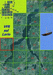
This is the third scenery of the "VFR of Lario" project, with photorealistic terrain and some 3D GMax realistic objects.
Information: this third scenery covers approximately an area of 7.5x6 kmt, from Pellio Intelvi/Ramponio (NW) to Colonno (NE), and from Almanno/Vesbio (SW) to Cavagnola locality (SE) and includes some details (GMax) of Argegno town, as NLC pier, some Holtel and Restaurants, the SS. Trinity church, some bridges and walls on Telo torrent and the cableway Argegno-Pigra (animated); it is also enclosed the unique small museum of financial police and smuggling, on Erbonne.
Contents: GMax objects as above and other buidings, minor piers and boats together with autogen buildings and trees are fully spreaded on the scenery.
| Filename: | VFR_of_Lario_Area_C1__Como_lake_Italy.zip |
| License: | Freeware |
| Added: | 16th February 2012, 00:17:59 |
| Downloads: | 1,778 |
| Author: | Aldo Della Vedova, Daniele Lanfranchi, Gian Mario Verga e Diego Caligiuri |
| Size: | 12.98 MB |
| Category: Flight Simulator X - Scenery | |
| X3SF- Snitterfield - Warwickshire, England |
|
File Description:
RAF Snitterfield (ICAO x3SF) is a former Royal Air Force station located west of Snitterfield, Warwickshire, England, 3.3 miles (5.3 km) north of Stratford-upon-Avon and 4.6 miles (7.4 km) south-east of Henley-in-Arden, Warwickshire.
RAF Snitterfield was operational during the Second World War, the airfield was a class A airfield and had around 30 aircraft dispersals. The airfield was finished around June 1942 and cost around £1,147,000 and opened in 1943 and with the cessation of hostilities the Air Ministry having no further use for the Station it closed in 1946.
Source: Wikipedia.
| Filename: | X3SF_Snitterfield__Warwickshire_England.zip |
| License: | Freeware |
| Added: | 14th May 2016, 11:42:00 |
| Downloads: | 108 |
| Author: | Terry Boissel |
| Size: | 1.54 MB |
| Category: Fly! II - TerraScene | |
| Maysville (Ohio Project) TerraScene Project Pack |
|
File Description:
This is a TerraScene 2.1 Project pack for southern Ohio and portions of northern Kentucky. It covers all of global tile 196,157 with Maysville, KY in the center. Above the Ohio River, you will find a portion of southern Ohio, with rolling hills and small towns, extending from Portsmouth, OH in the east to just below Cincinnati in the west. This pack includes updated Tiger Census (2000) shapefile data, adding new water areas, new highways, and other details. All scenery data files are included: USGS data, shapefiles, and a complete water mask. Requires TerraScene 2.1 and Fly!II patched to v230 or later.
| Filename: | Maysville_Ohio_Project_TerraScene_Project_Pack.zip |
| License: | Freeware |
| Added: | 4th May 2003, 14:51:31 |
| Downloads: | 174 |
| Author: | Randall Rocke |
| Size: | 61.6 MB |


© 2001-2026 AVSIM Online
All Rights Reserved
Privacy Policy |