
Where Flight Simulation Enthusiasts Gather from Around the World!
AVSIM Library - Search Results

| Category: Flight Simulator 2004 - AI Flight Plans | |
| RAAF East Sale Complete AI Package |

|
Images related to this file:
File Description:

The members of Military AI Works are proud to bring you the RAAF East Sale Complete AI Package for FS2004. This package depicts the PC-9 operations at RAAF East Sale. Credits: Models by Mark Griggs and Kevin Reed, Repaints by Andrew Hall and Mark Griggs, FDE/Effects by Mike MacIntyre, Nick Needham and Henry Tomkiewicz, Flightplans by Mark Campbell, VCPs by Stewart Pearson and Scenery Objects by Mark Griggs, Anthony Lynch and Laurie Nichols
| Filename: | RAAF_East_Sale_Complete_AI_Package.zip |
| License: | Freeware, limited distribution |
| Added: | 5th September 2012, 00:23:06 |
| Downloads: | 404 |
| Author: | Mark Campbell, Military AI Works (MAIW) |
| Size: | 18.27 MB |
| Category: Flight Simulator 2004 - Aircraft Repaints, Textures and Modifications | |
| Herald Channel Express Early ex Arkia Livery |
|
File Description:
Originally 4X-AHS with Arkia of Israel, G-BEZB was one of four machines bought by Express Air Services/Express Air Freight. Supposingly merged with Intra and ABC to form Jersey European Airways, ABC stayed seperate and Express became Channel Express. Despite all the changes 'Blossom' remained, up until withdrawl in 1987 still wearing its basic original Arkia livery. Requires the FSDS Herald model by Rick Piper http://www.btinternet.com/~rick.piper/index.htm
| Filename: | Herald_Channel_Express_Early_ex_Arkia_Livery.zip |
| License: | Freeware |
| Added: | 2nd November 2004, 23:31:49 |
| Downloads: | 263 |
| Author: | Garry Russell |
| Size: | 414.88 KB |
| Category: Flight Simulator 2004 - Aircraft Repaints, Textures and Modifications | |
| IAF C-130 |
|
File Description:
FS2004 This is a repaint of Lockheed Martin C-130. You must have the Lockheed Martin C-130 from Alphasim for this to work. This file contains textures only! This is a repaint of a Israel Air Force "Yellow Bird" C-130 from 131Sqn based at BG-Lod. Repaint by Gregory Paul
| Filename: | IAF_C130.zip |
| License: | Freeware |
| Added: | 15th August 2004, 17:22:48 |
| Downloads: | 1,189 |
| Author: | Gregory Paul |
| Size: | 3.13 MB |
| Category: Flight Simulator 2004 - Scenery | |
| Railroad "Under" textures for Ultimate Terrain v1.2 |
|
File Description:
The textures are for UT Canada/Alaska 1.2. These textures will greatly reduce the width of the underlay of Ultimate Terrain enhanced railroad tracks which I feel are too wide. Be aware that these changes will also affect the look of the divided Highways.
| Filename: | Railroad_Under_textures_for_Ultimate_Terrain_v12.zip |
| License: | Freeware |
| Added: | 15th December 2005, 04:10:26 |
| Downloads: | 1,794 |
| Author: | Jim Kanold - Flight Ontario |
| Size: | 50.66 KB |
| Category: Flight Simulator X - Scenery | |
| Nunavik project for Ultimate Terrain X Canada |
|
Images related to this file:
File Description:
Scenery files for 16 « forgotten » towns located in the northen part of Quebec, the Nunavik. Must have Ultimate Terrain X Canada installed. Airports modified to permit helicopter traffic and Air Inuit and First Air flights. More info in the *.rtf files.
| Filename: | Nunavik_project_for_Ultimate_Terrain_X_Canada.zip |
| License: | Freeware |
| Added: | 6th November 2009, 23:52:24 |
| Downloads: | 873 |
| Author: | Pierre Fauteux |
| Size: | 6.24 MB |
| Category: Civil Flight Simulators - Looking Glass Flight Unlimited 3 | |
| FU3 Outer Terrain GTL Tile Editor v2.0 |
|
Images related to this file:
File Description:
This spreadsheet allows you to view, edit and save changes to the outer terrain's GTL tiles. Tiles are loaded into a 256x256 grid and the 13 default terrain textures are represented by cell background colours, i.e. the Mesa texture is represented by a reddish-brown background colour. The controls for loading and saving tiles are deliberately located on a separate worksheet. When loading and saving tiles I recommend that you do NOT select the main FU3 GTL Editor worksheet until a message box informs you that the load/save has finished. Otherwise, load/saves times (approx. 30 seconds for an average tile) will increase dramatically if you watch the tile while it is being populated or saved.
This 2.0 version also allows you to load a tile's terrain elevation. This is useful because the rules-based approach to modifying the OT was based on altitude constraints and it helps to be able to view the elevation (on the same scale as the tile itself) when modifying the terrain. However, in order to load the elevation you must first load the corresponding GTL tile. There is no provision to modify or save the elevation, because we already have Andre's excellent tools for that.
A complete map of the outer terrain's 2296 GTL files (plus Andre's 164 tile extension to the north) is provided in a separate worksheet. This includes a search facility you can use to identify tiles based on FU3 world co-ordinates.
| Filename: | FU3_Outer_Terrain_GTL_Tile_Editor_v20.zip |
| License: | Freeware |
| Added: | 26th December 2009, 02:11:13 |
| Downloads: | 49 |
| Author: | Jonathan Stonehouse |
| Size: | 103.36 KB |
| Category: Civil Flight Simulators - Looking Glass Flight Unlimited 3 | |
| Outer Terrain GTL Grid Structure Map v2.0 |
|
Images related to this file:
File Description:
This version of my GTL grid structure map includes Andre's new outer terrain area north of Seattle and adds a search facility, which enables you to search for a tile using FU3 world co-ordinates. To find out the world co-ordinates of any OT area simply open Fled, set the top-down view to the latitude/longitude of the area you're interested in and click the latitude/longitude figures that appear in the bottom left hand corner of the screen. The latitude/longitude figures will disappear and be replaced by FU3 world co-ordinates as easting and northing values. Enter these values into my FU3 GTL Map, click the button and the spreadsheet will map these co-ordinates to the correct tile and return the tile name. If you don't know the latitude/longitude of the area you're interested in then you can always obtain this from within the game itself. Just start a flight in the area you're interested in and press Ctrl-z at any time to enter Zoar mode. This will pause the game and display the current latitude/longitude in the top left hand corner of the screen.
| Filename: | Outer_Terrain_GTL_Grid_Structure_Map_v20.zip |
| License: | Freeware |
| Added: | 29th December 2009, 23:16:52 |
| Downloads: | 35 |
| Author: | Jonathan Stonehouse |
| Size: | 198.97 KB |
| Category: Flight Simulator 2004 - Scenery | |
| Vancouver Default Object Corrections for Ultimate Terrain |
|
Images related to this file:
File Description:
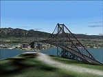
The default shorelines that come with Microsoft Flight Simulator 2004 are inaccurately placed. Consequently roads and other features are misplaced. Ultimate Terrain (R) from Flight One Software corrects this, however the Microsoft default objects are then misplaced. This software corrects the Lions Gate Bridge, Canada Place, Harbour Centre, Burrard Bridge, Science World and BC Place Stadium. Further it excludes a number of generic MS buildings that are now placed in False Creek. For developers, the XML code is included. Users may delete this file. Ultimate Terrain required. By Jon Patch
| Filename: | Vancouver_Default_Object_Corrections_for_Ultimate_.zip |
| License: | Check within download |
| Added: | 5th May 2010, 21:43:07 |
| Downloads: | 3,518 |
| Author: | Jon Patch |
| Size: | 288.76 KB |
| Category: Flight Simulator 2004 - Scenery | |
| Anchorage - Yukon Landclass Adjustment for UT terrain |
|
File Description:
Anchorage-Yukon Landclass
Missing City and Landscape Landclass for Ultimate Terrain
from Anchorage to Fairbanks Beever Creek - Dawson - Whitehorse
Only copy the bgl files in a addon/scenery folder above the UTCanada folder
Including raw files for your own adjustments with LWM Viewer or EZscenery.
| Filename: | Anchorage__Yukon_Landclass_Adjustment_for_UT_terra.zip |
| License: | Freeware |
| Added: | 2nd August 2016, 17:09:10 |
| Downloads: | 242 |
| Author: | Markus Balz |
| Size: | 158.43 KB |
| Category: Flight Simulator 2004 - Scenery | |
| Fort Resolution CYFR in the Northwest Territories, Canada |
|
Images related to this file:
File Description:
Fort Resolution is on the south side of Great Slave Lake, 75 miles east of Hay River and just west of where the Slave River flows into the lake from Fort Smith. Fort Resolution, the oldest community in the Territories and once a vital link in the fur trade business, is a small town with a population of around 500. It was not included in the original FS9 or Ultimate Terrain so I have added it here.
The airfield is next to the town on the lakeshore. The runway is 4,000 feet of gravel with a displaced threshold at the southern (town) end; it is lit and there is PAPI. There are no scheduled flights to Fort Resolution, just occasional charters; the AI includes a stock FS9 Cessna and a Wasaya Airways PC12.
| Filename: | Fort_Resolution_CYFR_in_the_Northwest_Territories_.zip |
| License: | Freeware, limited distribution |
| Added: | 4th October 2013, 22:11:26 |
| Downloads: | 294 |
| Author: | Roger Wensley |
| Size: | 2.31 MB |


© 2001-2026 AVSIM Online
All Rights Reserved
Privacy Policy |