
Where Flight Simulation Enthusiasts Gather from Around the World!
AVSIM Library - Search Results

| Category: Combat Flight Simulators - Strike Fighters: Project 1 | |
| WWII Darwin/Timor Terrain |

|
File Description:
This is a complete WWII Darwin/Timor/Indonesia 1942-45 Terrain with accurate Target placements for Strike Fighters Project 1. You will need the Pacific Objects download to fully use this terrain.
| Filename: | WWII_DarwinTimor_Terrain.zip |
| License: | Freeware |
| Added: | 30th September 2005, 23:42:36 |
| Downloads: | 204 |
| Author: | Edward Eisler |
| Size: | 30.46 MB |
| Category: Civil Flight Simulators - Looking Glass Flight Unlimited 3 | |
| Outer terrain north expansion |
|
Images related to this file:
File Description:

This outer terrain expansion kit will expand the OT area of flight3
from 41x56 tiles to 41x60 including the northern area of Vancouver up
to 50 degrees north.
This expansion has 2 parts:
1. OutTagD.tag : Vancouver area 4x12 tiles full configured
with terrain class and terrain hight.
2. OutTagE.tag : a needed space holder expansion of 29x4 flat forest
tiles to make the total rectangle of 41x60 tiles.
You don't need the line : use_loose_gtls in flt3.cfg
If you want to use use_loose_gtls then you must move all gtl files from
the folder GTLs into the outterr folder.
Vancouver Int. airport YVR is integrated as a simple example into this kit.
Select it using the Outter map.
| Filename: | Outer_terrain_north_expansion.zip |
| License: | Freeware, limited distribution |
| Added: | 2nd December 2009, 03:59:47 |
| Downloads: | 97 |
| Author: | Andre Meystre |
| Size: | 11.86 MB |
| Category: Flight Simulator 2004 - Scenery | |
| Alternate Ultimate Terrain Roads |
|
File Description:
ALTERNATE ULTIMATE TERRAIN ROADS
by Adnan 'Reload006' Arif (BEV team)
Being an autogen designer in the Birds Eye View team inspired me to manipulate whatever I can to make FS9 look as realistic as possible. This is an alternate set of concrete and asphalt highways and local roads, color matched exactly to photographs of roads and highways, and with more realistic local roads. THESE WILL ONLY WORK WITH ULTIMATE TERRAIN, and you need to have purchased Ultimate Terrain USA/Canada to make these work.
INSTALLATION :
They are simply installed into FS9/texture. The default 'bright' UT roads are also included in case you`d like to revert back to them.
The screenshots I have included are all with BEV summer textures. (www.flightsim-bev.com). I strongly advise getting Ultimate Terrain if you dont have it already, as it will greatly enhance your road/river/water bodies network . Also, if you change a setting in Ultimate Terrain, you will probably have to reinstall these roads. They should work with UT settings of 'residential roads on' or with 'main highways and roads only' .
Enjoy!
Adnan Arif/ aka Reload006.
[email protected]
| Filename: | Alternate_Ultimate_Terrain_Roads.zip |
| License: | Freeware |
| Added: | 13th March 2006, 02:28:26 |
| Downloads: | 7,299 |
| Author: | Adnan Arif |
| Size: | 6.55 MB |
| Category: Flight Simulator X - Original Aircraft | |
| Project All-terrain vehicle |
|
File Description:
Project All-terrain vehicle, "you find it under FTBVA".All-terrain vehicle with differnd 10 skins,Track and Mission will be follow soon. You find more models here on AVSIM under Dirk Stuck . © by Fireeagle 2008 By Dirk Stuck EMail:[email protected]
| Filename: | Project_Allterrain_vehicle.zip |
| License: | Freeware |
| Added: | 27th June 2008, 22:49:01 |
| Downloads: | 1,396 |
| Author: | Dirk Stuck |
| Size: | 6.52 MB |
| Category: X-Plane - Scenery | |
| WXPJ Susi Air Puncak Jaya Mining Airstrip v1.0.0 |
|
Images related to this file:
File Description:
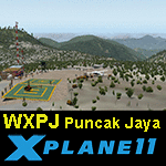
This is an X-Plane 11 scenery for Puncak Jaya Mining Airstrip (WXPJ) in the Puncak Jaya mountain region of Papua, Indonesia. This is a fictitious airfield, located in a high altitute mining location in Papua. At 4884 metres (16024 ft) above sea level, the Puncak Jaya peak, next to the mining location, is the highest mountain in Indonesia, on the island of New Guinea (which consists of the Indonesian West Papua region plus Papua New Guinea). This fictitious airfield may serve as a high altitute mining location challenge while flying the airstrips in Papua, as one of the destinations for "PT ASI Pujiastuti Aviation", operating as Susi Air, an Indonesia airlines established in late 2004 by Mrs. Susi Pudjiastuti. This scenery was tested and is operational (as of January 20, 2017) in "X-Plane 11 Public Beta #6 64 bit", Windows 10 Home. It was also tested and is partially operational (as of January 20, 2017) in "X-Plane 10.51 64 bit", Windows 10 Home. The issue with XP10 is the mesh again: there is no mine mesh, just a whole. The feel is very different from XP11, but it is still operational in XP10 to fly in and out.
| Filename: | WXPJ_Susi_Air_Puncak_Jaya_Mining_Airstrip_v100.zip |
| License: | Freeware |
| Added: | 21st January 2017, 18:42:35 |
| Downloads: | 58 |
| Author: | Rui Mesquita |
| Size: | 2.2 MB |
| Category: Flight Simulator 2004 - Helicopters | |
| IAF UH-60 "yanshuf" |
|
File Description:
The 3ed version of my texture to the BlackHawk #741 from The "Birds of the Desert" Squadron in the IAF (Israel Air Force),include the model by Jordan Moore\HoverControl.
| Filename: | IAF_UH60_yanshuf.zip |
| License: | Freeware, limited distribution |
| Added: | 19th March 2005, 13:48:27 |
| Downloads: | 3,681 |
| Author: | Ofek Sinai, HoverControl, Jordan Moore |
| Size: | 8.15 MB |
| Category: Flight Simulator 2004 - Aircraft Repaints, Textures and Modifications | |
| El Al Israel Airlines Boeing 737-700"4X-EKD" |
|
File Description:
This aircraft is registered Bo737-700 El Al Israel Airlines"4X-EKD".You must own the Overland/Simmer's Sky payware Boeing 737-700 model for these textures to work properly.
| Filename: | El_Al_Israel_Airlines_Boeing_7377004XEKD.zip |
| License: | Freeware |
| Added: | 24th August 2007, 15:54:33 |
| Downloads: | 624 |
| Author: | Kittisak Rukkaew/ucom04 |
| Size: | 3.22 MB |
| Category: Flight Simulator 2004 - Aircraft Repaints, Textures and Modifications | |
| El Al Israel Airlines Boeing 737-800"4X-EKP" |
|
File Description:
This aircraft is registered Bo737-800 El Al Israel Airlines"4X-EKP".You must own the Overland/Simmer's Sky payware Boeing 737-800 model for these textures to work properly.
| Filename: | El_Al_Israel_Airlines_Boeing_7378004XEKP.zip |
| License: | Freeware |
| Added: | 24th August 2007, 15:55:11 |
| Downloads: | 851 |
| Author: | Kittisak Rukkaew/ucom04 |
| Size: | 3.36 MB |
| Category: Flight Simulator X - AFCAD Files | |
| Peaslees Airstrip Airport (NJ25), New Jersey |
|
File Description:
Located 01 miles SW of Clarksboro, New Jersey on 8 acres of land, Peaslees Airstrip is a private turf field 2207' in length. The hard surface runway has been removed to allow for landings on terrain, so have your terrain mesh set as high as possible. The surrounding area of rural farmland and houses has been filled in to provide an encompassing ground environment with as few breaks to the horizon as possible. There are no services at this airport - if you arrive there is room past the hangar to park and tie down although no tie downs are available in real life, thus you can only start from this airport on the runway. The windsock is located approximately midfield of the runway, as in real life. A second hangar has been constructed nearby the current one, but MSE textures do not reflect this and it was not included. This airport is not lit and daytime VFR operations only are recommended.
Scenery constructed with use of satellite images/streetview/aerial photos - the author has not been there in person.
This scenery is meant to be used in conjunction with MegaScenery Earth New Jersey/Delaware 004. It is not required, but apron use is minimized to allow satellite scenery to show through as much as possible, and objects are placed based on the MSE textures - lack of it may make scenery look out of place.
| Filename: | Peaslees_Airstrip_Airport_NJ25_New_Jersey.zip |
| License: | Freeware |
| Added: | 20th August 2011, 19:56:22 |
| Downloads: | 160 |
| Author: | Drew Sikora |
| Size: | 1 MB |
| Category: Flight Simulator X - Aircraft Repaints, Textures and Modifications | |
| Thomas Cook "Egypt Promotional" Boeing 757-200 |
|
Images related to this file:
File Description:

Thomas Cook 757-200 Egypt 'Where it all begins' Tourism livery for G-TCBB & G-TCBC.
G-TCBB/C are currently based at Birmingham & Newcastle this winter and are Thomas Cooks youngest 757-200 in the fleet. This has been a very challenging repaint , all the work with the Egypt promotion has been carefully cut from photo real images and edited to fit the complex repaint kit therefor this repaint I would say is about 95% accurate.
*Texture files only , Requires Payware Captain Sim 757-200*
| Filename: | Thomas_Cook_Egypt_Promotional_Boeing_757200.zip |
| License: | Freeware |
| Added: | 31st December 2012, 11:28:06 |
| Downloads: | 722 |
| Author: | Liam Donaldson - Captain Sim |
| Size: | 9.22 MB |


© 2001-2026 AVSIM Online
All Rights Reserved
Privacy Policy |