
Where Flight Simulation Enthusiasts Gather from Around the World!
AVSIM Library - Search Results

| Category: Flight Simulator 2002 - Scenery | |
| Alava (Basque Country, Spain) - Photorealistic |

|
Images related to this file:
File Description:
Re-upload. This is the Photorealistic Scenery of the Province of Alava (Basque Country, Spain) for FS2002. Also valid for FS2004. It includes the mesh (LOD9) of the Basque Country and surroundings. To enjoy VFR flights take off from Foronda (LEVT), which is included in a beta version; discover all the marvelous landscapes of my province!!
| Filename: | Alava_Basque_Country_Spain__Photorealistic.zip |
| License: | Freeware |
| Added: | 21st July 2010, 00:33:14 |
| Downloads: | 2,263 |
| Author: | Carlos Martinez de Guerenu |
| Size: | 97.81 MB |
| Category: Flight Simulator 2004 - Scenery | |
| CTH3 Canada, Quebec, Les Grandes-Bergeronnes |
|
Images related to this file:
File Description:
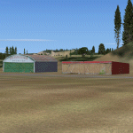
This is the scenery Les Grandes Bergeronnes (CTH3), which represents the reality. Les Grandes Bergeronnes is a small village located on Northern bank of the St-Laurent river of Quebec at Canada. This scenery is designed with FSDS and it accepts Mesh of Gilles Gauthier. This scenery functions for both FS-2004 and FS-X.
| Filename: | CTH3_Canada_Quebec_Les_GrandesBergeronnes.zip |
| License: | Freeware |
| Added: | 2nd January 2010, 19:29:43 |
| Downloads: | 374 |
| Author: | Regis Dassylva |
| Size: | 2.32 MB |
| Category: Flight Simulator 2004 - AFCAD Files | |
| Sucre SLSU Bolivia |
|
Images related to this file:
File Description:
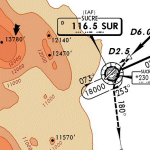
AFCAD file for FS2004 default scenery of Sucre SLSU Juanna A. De Padilla airport in Bolivia.
Brings runway to proper dimensions and adds approach (PAPI) lighting as in the real airport.
High elevation airport (9430 ft.) with surrounding terrain of the Bolivian Andes.
There is no night lighting at this airport. Approach charts included. Recommended mesh terrain: mesh_fermandois003_265585.zip
| Filename: | Sucre_SLSU_Bolivia.zip |
| License: | Freeware, limited distribution |
| Added: | 19th March 2010, 08:55:01 |
| Downloads: | 561 |
| Author: | Kyprianos Biris |
| Size: | 683.9 KB |
| Category: Flight Simulator 2004 - Scenery | |
| Karipur VOCL |
|
Images related to this file:
File Description:
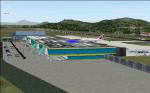
Karipur-VOCL for FS2004.
This contains the Airport of Calicut, Kerala, India
Karipur is a new International airport in Kozhikode or Calicut.
It handles planes to Middle East and Domestic.
This file contains the real airport.
Requeres South India Mesh and EZ library for small objects
to show up.
Terminal made in gmax and small objects added with EZ.
| Filename: | Karipur_VOCL.zip |
| License: | Freeware, limited distribution |
| Added: | 1st October 2010, 17:44:35 |
| Downloads: | 1,160 |
| Author: | Anstin Antony |
| Size: | 2.21 MB |
| Category: Flight Simulator 2004 - Scenery | |
| Lauterbrunnen LSXL |
|
File Description:
Scenery of the Air Glaciers heli base at Lauterbrunnen in the Bernese Oberland. The scenery contains Mönchsjochhütte, the highest refuge in the Bernese Alps, situated South of Mönch. The scenery has been designed in Gmax and optimized for the mesh of Switzerland Professional. In order to save system performance, a series of LODS have been created.
| Filename: | Lauterbrunnen_LSXL.zip |
| License: | Freeware |
| Added: | 13th July 2006, 02:58:06 |
| Downloads: | 3,535 |
| Author: | Michael Röthlisberger |
| Size: | 3.25 MB |
| Category: Flight Simulator X - Scenery | |
| SICILY VFR X - Lakes and Reservoir. |
|
File Description:
This scenery is a remodelling of the basic FSX Sicily lakes based on Google Earth's representation. Some lakes exists in FSX (but low resolution). I have workerd on them, add more not represented, with FSX KML v1.10 Beta by Innova Software.
This add-on scenery is full compatible with SICILY VFR - Terrain Mesh SRTM3 version 2.
| Filename: | SICILY_VFR_X__Lakes_and_Reservoir.zip |
| License: | Freeware |
| Added: | 14th February 2008, 22:59:44 |
| Downloads: | 2,794 |
| Author: | Giovanni Miduri |
| Size: | 2.77 MB |
| Category: Flight Simulator 2004 - Gauges | |
| Apollo PVI (Pilot Vehicle Interface) /GPS |
|
File Description:
This gauge is modeled after the Apollo PVI for commercial jet aircraft. This gauge is written in XML and is designed to mesh with the default FS9GPS map input data. Compatible with FS2004 (FS9) ONLY! Size (pixel size) is the same as the FS9 default GPS so placement (or replacement) of the gauge is quick and easy.
| Filename: | Apollo_PVI_Pilot_Vehicle_Interface_GPS.zip |
| License: | Freeware |
| Added: | 24th December 2003, 05:34:07 |
| Downloads: | 5,088 |
| Author: | Keith Giveans |
| Size: | 97.88 KB |
| Category: Flight Simulator 2004 - Gauges | |
| Garmin GNS430 And GNS530 GPS Radios |
|
File Description:
Garmin GNS430 and GNS530 GPS Com/Nav Radios for FS2004. These radios are a mesh of the default GPS500 and a large number of new functions specific to either the GNS430 or -530. New functions include a popup map page with nav bar in the GNS530, and new map and position pages in the GNS430. Installation guidelines included.
| Filename: | Garmin_GNS430_And_GNS530_GPS_Radios.zip |
| License: | Freeware |
| Added: | 17th October 2003, 22:04:13 |
| Downloads: | 12,349 |
| Author: | Don Kuhn |
| Size: | 988.36 KB |
| Category: Flight Simulator 2004 - Scenery | |
| Altitude adjustment for Dawson City CYDA |
|
Images related to this file:
File Description:
I discovered that the Northern Canada Terrain Mesh that I installed a while back was dumping part of my Dawson City Airport CYDA into a deep hole. I tried making a flatten to reduce the height of the terrain mesh land but that did not look at all realistic. So, the solution is to raise CYDA to 1,457 feet above sea level instead of the correct (correct according to the Nav Canada Supplement) level of 1,215 feet so that it melts into the surrounding terrain. There are still some rocky faces but at least they are not in the airfield. Do you need it? Not if your version looks ok. If it doesn't look ok then try this, but save your current version so you can go back to it if you need to.
| Filename: | Altitude_adjustment_for_Dawson_City_CYDA.zip |
| License: | Freeware, limited distribution |
| Added: | 23rd July 2019, 17:24:26 |
| Downloads: | 102 |
| Author: | Roger Wensley |
| Size: | 855.58 KB |
| Category: Flight Simulator 2004 - Scenery Design | |
| Kijik Lake_version2 |
|
File Description:
Version 2_contains the updated AFCAD2 BGL.
Kijik Lake, Alaska is located within the boundaries of the 4 million acre Lake Clark National Park and Preserve. It is 6nm north of Port Alsworth (TPO) on the NW side of Lake Clark. Two new cabins and homey wall tents are provided for hunters, fishermen, campers, hikers and explorers who wish to submerge themselves in the best of Alaska's wilderness scenery. This roadless and trailless wilderness is accessed by air service only. Kijik Lake has a new floatplane dock and a very landable dirt/gravel shoreline airstrip. Plan your next flight to Kijik Lake where you'll find a warm fire, a great meal and unsurpassed hospitality.
Created for FS9's default mesh, but works equally well with Eddie Denney's Alaska 2000 or 2002 mesh.
| Filename: | Kijik_Lake_version2.zip |
| License: | Freeware, limited distribution |
| Added: | 21st March 2004, 22:50:27 |
| Downloads: | 639 |
| Author: | Brent Hricziscse |
| Size: | 1.85 MB |
© 2001-2026 AVSIM Online
All Rights Reserved
Privacy Policy |