
Where Flight Simulation Enthusiasts Gather from Around the World!
AVSIM Library - Search Results

| Category: Flight Simulator 2004 - Scenery | |
| Airstrips of Central Germany |

|
Images related to this file:
File Description:

Another selection in my Airstrips of Western Europe project, herewith 80+ small airfields in central Germany, each enhanced with taxiways, parking spaces, buildings etc. and aprons as appropriate, to further facilitate the generation of lightweight AI traffic in the area, without overloading the more major airfields.
Again, there's no photo-realism here, just a selection of basic 'generic' buildings, more or less accurately sized and placed to reflect the airfield layout as seen on on-line satellite imagery and aerial photography. These buildings have minimal effect on frame-rates, so are ideal for this kind of job. The airfields are aligned as well as possible with the roads etc. in UT Europe and the Genesis Europe mesh, but should mostly be fine in a default installation or other configuration.
As before, the files for each airfield can be easily identified by the ICAO code, even if the airfield names vary slightly, so you can pick and choose and mix and match to suit any sceneries you already have, should you so wish. There is no requirement for any other download. Each airfield will exist as a stand-alone entity should you only want a few of them.
Please read the rest of this "blurb" in the included text file. There may be some details of note or interest.
| Filename: | Airstrips_of_Central_Germany.zip |
| License: | Freeware |
| Added: | 26th February 2025, 19:22:06 |
| Downloads: | 108 |
| Author: | Chris Eve |
| Size: | 1.14 MB |
| Category: Flight Simulator 2004 - Scenery | |
| Union Island TVSU in the Grenadines, eastern Caribbean Version 1.1 |
|
Images related to this file:
File Description:
This is a self-contained version 1.1 that modifies the terrain flattens around the airport. I found that suddenly, and for no apparent reason, the Lesser Antilles mesh and my flattens were at war and creating hills within the airport boundary. If you are not having problems then you do not need this.
Union Island is in the southern tail of the chain of islands known as St Vincent and the Grenadines, between Canouan and Carriacou. Union is another small island, 3.5 miles long and at its widest 1.5 miles wide; the resident population is around 3,000, mostly in the two towns Clifton and Ashton. The airport is at the eastern end of the island, and has been extended into the sea on landfill. The runway is now around 2,480 feet long, aligned 08 (and with the southeast trade winds it is unlikely that you will find yourself using 26) and with a displaced threshold of 530 feet due to the hill to the west. The terminal is adjacent to a rather small apron; there is parking on the grass north of the taxiway. There are connecting flights by SVG to Barbados and the other islands and these are reflected in the AI. The airport has no lighting, and flights are obliged to land and depart in daylight hours only, outside of which the airport is closed.
| Filename: | Union_Island_TVSU_in_the_Grenadines_eastern_Caribb.zip |
| License: | Freeware, limited distribution |
| Added: | 16th June 2013, 18:46:33 |
| Downloads: | 525 |
| Author: | Roger Wensley |
| Size: | 2.02 MB |
| Category: Flight Simulator 2004 - Scenery | |
| LFRD2004 Dinard/St-Malo VFR Scenery |
|
Images related to this file:
File Description:
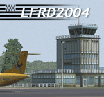
LFRD is a regional airport in Brittany, France. This scenery was created entirely with GMax and the latest Microsoft compilers. Everything was made to ensure maximum framerate while giving maximum visual impact, even on humbler machines. This scenery will run just as fast as the default one (which is very bare) with your current settings, even though there are literally thousands of houses, buildings, trees and a detailed airport.
This is a complete package:
-SRTM local mesh with custom coast trimming
-Custom phototexture (200sq km), with seamless blending into FS9 standard landclass
-Full autogen with custom local texture
-Custom landclass and waterclass
-AFCAD2 file with parking codes
-Custom Hi-res photographic textures at airport.
-Gmax buildings and xml librairy objects.
It was made by a real life pilot and is totally aimed at recreating the feeling of being there, not so much on the ground (after all, this is a FLIGHT simulator), but at circuit altitudes. This is not about recreating an airport in all its glorious details at the cost of framerate, but instead an exercise in balancing visual cues and details as viewed from up there to make it 'as real as it gets' within the limits of FS9. Scenery made by Vauchez (http://mapage.noos.fr/euro_vauchez/)
| Filename: | LFRD2004_DinardStMalo_VFR_Scenery.zip |
| License: | Freeware, limited distribution |
| Added: | 28th April 2010, 18:06:05 |
| Downloads: | 46,557 |
| Author: | Etienne Vauchez |
| Size: | 10.55 MB |
| Category: Flight Simulator 2004 - Scenery | |
| Exploring Our World - Part 2 - Easter Island, Chile - SCIP - a complete makover. |
|
File Description:
Exploring Our World - Part 2 - Easter Island, Chile. In part two of this new series you will find a complete makeover of Easter Island which MS virtually ignored. Designed to compliment the fine Mataveri International Airport by Daniel Rojas (scip_o7.zip at Flightsim.com), this package includes Mesh and adjusted coastlines by John Young. John has also provided a new Afcad which removes unrealistic pushback starts. A new landclass file by John Burford adds the villages near the airport and more realistic ground treatments. You will also find numerous scenery enhancements using objects from the RWY12 and EZ Scenery libraries. Francisco Vargas has contributed a set of Thermals which soaring fans will enjoy. Of special interest is the use of AI Volkswagens, as taxi's driving around the airport and AI Helicopters that take visiting tourists on sightseeing tours. The AI Volkswagens have been provided by Ranier Girbig and are used with his permission. Easter Island, home of the mysterious head statues (Moai) has many new and exciting things just waiting for you to explore. Even the small adjacent Moto Nui Island, which MS forgot, has been added. This is the second of a series exploring lesser known parts of our FS world. Please unzip (using folders option) to a temporary folder and follow the documentation very carefully to assure a proper installation. ......
| Filename: | Exploring_Our_World__Part_2__Easter_Island_Chile__.zip |
| License: | Freeware |
| Added: | 13th July 2006, 03:22:45 |
| Downloads: | 6,691 |
| Author: | David "Opa" Marshall and friends |
| Size: | 6.7 MB |
| Category: Flight Simulator X - AFCAD Files | |
| Stallone Airport (9NJ5), NJ |
|
File Description:
Located 01 miles SE of Harrisonville, New Jersey, Stallone Airport is a private turf strip 1350' in length. However it should be noted that the actual length from the road to the trees on the opposite end of the runway is actually only around 900'. It is tightly hemmed in by trees so if you are landing on Runway 29 you may want to use Slew to turn your plane around to remove the risk of bumping into a tree instead. If you land on Runway 11 you can cross the road to turn around in the field opposite the runway. The windsock can be seen from both runways. Power lines run along the heights of the trees as well for the Runway 29 approach, on the same side as the trees though so not really any additional worry there. No transient services are available. There is no hard surface runway so make sure your terrain mesh slider is set as high as possible for a suitably bumpy ground experience.
Scenery constructed with use of satellite images/streetview/aerial photos - the author has not been there in person.
This scenery is meant to be used in conjunction with MegaScenery Earth New Jersey/Delaware 004. It is not required, but apron use is minimized to allow satellite scenery to show through as much as possible, and objects are placed based on the MSE textures - lack of it may make scenery look out of place.
| Filename: | Stallone_Airport_9NJ5_NJ.zip |
| License: | Freeware |
| Added: | 5th April 2011, 07:34:54 |
| Downloads: | 170 |
| Author: | Drew Sikora |
| Size: | 332.91 KB |
| Category: Flight Simulator X - AFCAD Files | |
| Peaslees Airstrip Airport (NJ25), New Jersey |
|
File Description:
Located 01 miles SW of Clarksboro, New Jersey on 8 acres of land, Peaslees Airstrip is a private turf field 2207' in length. The hard surface runway has been removed to allow for landings on terrain, so have your terrain mesh set as high as possible. The surrounding area of rural farmland and houses has been filled in to provide an encompassing ground environment with as few breaks to the horizon as possible. There are no services at this airport - if you arrive there is room past the hangar to park and tie down although no tie downs are available in real life, thus you can only start from this airport on the runway. The windsock is located approximately midfield of the runway, as in real life. A second hangar has been constructed nearby the current one, but MSE textures do not reflect this and it was not included. This airport is not lit and daytime VFR operations only are recommended.
Scenery constructed with use of satellite images/streetview/aerial photos - the author has not been there in person.
This scenery is meant to be used in conjunction with MegaScenery Earth New Jersey/Delaware 004. It is not required, but apron use is minimized to allow satellite scenery to show through as much as possible, and objects are placed based on the MSE textures - lack of it may make scenery look out of place.
| Filename: | Peaslees_Airstrip_Airport_NJ25_New_Jersey.zip |
| License: | Freeware |
| Added: | 20th August 2011, 19:56:22 |
| Downloads: | 160 |
| Author: | Drew Sikora |
| Size: | 1 MB |
| Category: Microsoft Flight Simulator (2020) - Scenery Design | |
| MSFS 2020 object library with 200+ models ranging from towers hangars to cones (v10 12 extra models) |
|
Images related to this file:
File Description:
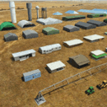
Object libraries for scenery developers (version 10 - improvements on curved surfaces + 10 lights(improved) + 3 windsocks + 3 animals + 5 animated people + 10 fuel_area +stable +fire_tower + 28 new fences + church + sheds). All objects in these libraries will be used in my own sceneries and the result of 100s hrs of effort. All objects from the real world. All objects use LOD (Level Of Detail) to keep frame rates high. Final long distance models have a large triangle added below ground to stop them disappearing in the distance. PBR materials used extensively. Included are 2 PDF files with photos of every object to make selection easy. Republish these files in any freeware scenery if required. READ "read me library instructions" before using.
---------------library1v10-cbj
Cones x4 Gables x3
Church x1
Fences (10 types farm chainlink x4 mesh x2 horse hand-rail paling cattle_grid) x94
Flag pole x1
Fuel_Signs_ x6
Fuel_area_pipes x2
Gas (petrol) station x3
Gliders x4
Glider trailers x4
Grain storage hoppers silos x 4
Power poles x2
Rail platforms station x5
Rail locomotive passenger_carriage grain_hoppers x5
Tower_forest_observation
Towers_radio x6
Weather station small x4
Windsock x3 Windsock-light x1
-------------library2v10-cbj
Animals - Cows x2 Sheep
Grain bunkers - large piles of grain covered with canvas x5
Hangars small airfield x15
Medical transfer station (building) x2
Obstacle-light x10
People x5 Men Women
Pivot irrigator x3
Sheds x10
Shelters x2
Terminals - small airfield x12
Water tanks x3
Towers water x4
Tractors farm x3
Water tanks x3
| Filename: | MSFS_2020_object_library_with_200_models_ranging_f.zip |
| License: | Freeware |
| Added: | 6th March 2022, 19:34:52 |
| Downloads: | 388 |
| Author: | COLIN JEFFERY |
| Size: | 198.25 MB |
| Category: Flight Simulator X - Scenery | |
| North Central Ecuador v3, including SEQM (SEQU) and SEIB |
|
Images related to this file:
File Description:
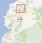
FSX/P3D Version 3 of this scenery is a completely new build of SEQM from the ground up. The entire complex is rendered using FSX objects along with the new highway that connects to the highway infrastructure with AI road traffic. The airport is now at a mean altitude that better blends with the newly included NASA SRTM GL1 30m mesh for the region. The tower is at the correct altitude. Buildings use more accurate footprints, new models, floating jetways, and updated landclass, and work seamlessly with the roads added by FTX Global/Vector. Lakes are corrected within roughly 100 square miles. Although the Ibarra/Atahualpa (SEIB) airport no longer exists, there is an option to add it back. Startup files are included to fly from the lakes and the Ibarra/Atahualpa (SEIB) airport. As a “bonusâ€, SEQU was restored in this version, because much of the footprint of the airport still remains as part of its conversion to a park. As such, a custom and fully functional SEQU is included for users who would like to revisit the old airport. AI Traffic can be restored at SEQU by simply using the "Reversed SEQU-SEQM AI Traffic" option. Scenery was created using Airport Design Editor X v1.76.6715, SBuilderX 3.13, and the FSX Object Placement Tool. Scenery objects were added and modified from stock FSX scenery to resemble as closely as possible the actual airport. Bill Leaming's Ramp Lights for P3D/FSX illuminate the aprons.
| Filename: | North_Central_Ecuador_v3_including_SEQM_SEQU_and_S.zip |
| License: | Freeware |
| Added: | 22nd March 2020, 22:13:37 |
| Downloads: | 4,089 |
| Author: | Carlyle Sharpe |
| Size: | 29.44 MB |
| Category: Flight Simulator 2004 - Scenery | |
| Lanseria International Airport (FALA), Johannesburg, South Africa |
|
Images related to this file:
File Description:
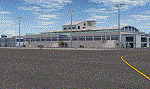
Lanseria international airport is Johannesburg's second international airport and mostly cater to private jets, low cost airlines and many private general aviation and flightschool aircraft. It is a privately owned airport and can accomodate aircraft up to the size of a Boeing 757-300. This airport has seen John Travolta use it with his Boeing 707, the Hilton family with a private Boeing 757 and even the USAF have landed their C-17 Globemasters at the airport when Air Force one came here in the past with the latter landing at AFB Waterkloof.
This package started out as a conversion of the wonderfull FSX scenery of the airport by Lee Hall and converted with permission from the original author. It quickly expanded however to a project that now additionally includes photoreal ground textures that changes with seasons, many added fences and gates around the airport, inclusion of the shaded parking areas with parked cars, static airplanes (RWY12 and EZ scenery libraries needed to see this) as well as numerous objects around the airport and apron made by myself in Gmax to give the airport some FS9 life.
Also included is the wonderfull "apron light splashes" by Hans Günther Schnell who kindly gave me permission to use it for the night times.
I have also included a local mesh for the area for users of FSGlobal 2010 to eliminate the extreme elevation anomoly around the airport.
| Filename: | Lanseria_International_Airport_FALA_Johannesburg_S.zip |
| License: | Freeware, limited distribution |
| Added: | 11th August 2023, 16:03:37 |
| Downloads: | 272 |
| Author: | Kobus van Wyk, Lee Hall |
| Size: | 37.64 MB |
| Category: Flight Simulator X - AFCAD Files | |
| Mount Pleasant Landing Strip Airport (67NJ), NJ |
|
File Description:
Located 01 miles S of Hainesburg, New Jersey on 192 acres of land, Mount Pleasant Landing Strip Airport is a private turf field. The strip itself is 2100 feet in length over fairly level ground. There is no hard-surfaced grass runway in place, so setting your mesh to the highest resolution is recommended as you will be landing on bare terrain. Next to Runway 06 is a path through the trees you can taxi along to get to a hangar - although it is not available for transient aircraft and is closed. Collision with the trees along the path near the hangar and the static aircraft parked near it is disabled to make it easier to move through this relatively tight area. Immediately beyond the hangar is a clearing with ample room to turn around to taxi back out. You can also start parked in front of the hangar. The windsock is located a few feet west of the hangar and is not lit. The runway also has no edge lighting so daytime VFR operations only are recommended for this airfield.
Scenery constructed with use of satellite images/streetview/aerial photos - the author has not been there in person.
This scenery is meant to be used in conjunction with MegaScenery Earth New York 007. It is not required, but apron use is minimized to allow satellite scenery to show through as much as possible, and objects are placed based on the MSE textures - lack of it may make scenery look out of place.
| Filename: | Mount_Pleasant_Landing_Strip_Airport_67NJ_NJ.zip |
| License: | Freeware |
| Added: | 7th February 2011, 23:49:26 |
| Downloads: | 198 |
| Author: | Drew Sikora |
| Size: | 468.64 KB |
© 2001-2026 AVSIM Online
All Rights Reserved
Privacy Policy |