
Where Flight Simulation Enthusiasts Gather from Around the World!
AVSIM Library - Search Results

| Category: Orbiter - Spaceships | |
| Surveyor Lunar Lander 1.0 |

|
File Description:
The Surveyor program consisted of seven unmanned lunar missions that were launched between May 1966 and January 1968. Five of these spacecraft, Surveyor 1, 3, 5, 6, and 7 successfully soft-landed on the lunar surface. In addition to demonstrating the feasibility of lunar surface landings, the Surveyor missions obtained lunar and cislunar photographs and both scientific and technological information needed for the Apollo manned landing program. Four spacecraft, Surveyor 1, 3, 5, and 6, returned data from selected mare sites from Apollo program support, and Surveyor 7 provided data from a contrasting rugged highland region.
The Orbiter version brings to you the historical flight of this unmanned lunar landing probe. The flight plan should bring you within 10,000 km of the Lunar surface. With one mid course correction, and enough practice, you can land it the moon.
| Filename: | Surveyor_Lunar_Lander_10.zip |
| License: | Freeware |
| Added: | 8th December 2004, 14:57:05 |
| Downloads: | 872 |
| Author: | James Williams |
| Size: | 1.97 MB |
| Category: Flight Simulator 2004 - Scenery | |
| Europe SRTM mesh part 01: LOD7 buffer mesh |
|
File Description:
Europe SRTM LOD9 mesh part 1 of 13: This is a LOD7 mesh covering the whole Europe from 35°N to 60°N and 12°W to 30°E, to be used as a buffer mesh in conjection with the LOD9 mesh. This Europe SRTM project was optimized for the lowest HDD space use: Each part macthing exactly the boundaries of its neighbors, you'll have a complete corevage of Europe without gap or overlapping scenery. Based on SRTM Data v1 and v2 (3 arcsec, 90m) and sampled to LOD7 resolution (300m). Each SRTM tile was carefully checked and repaired with Blackart v4.02: water areas are now flattened (lighter mesh), and SRTM voids were treated taking advantage of Blackart's sophisticated interpolation algorithm. When required, biggest voids were patched with oversampled SRTM 30 arcsec data and/or manual input.
| Filename: | Europe_SRTM_mesh_part_01_LOD7_buffer_mesh.zip |
| License: | Freeware, limited distribution |
| Added: | 19th October 2005, 16:11:05 |
| Downloads: | 19,066 |
| Author: | Yohann Baptiste |
| Size: | 50.28 MB |
| Category: Flight Simulator 2004 - Scenery | |
| Europe SRTM mesh part 10: Lower Danube |
|
File Description:
Europe SRTM LOD9 mesh part 10 of 13: Covers a wide area centered over the Danube valley from Novi Sad to the Black Sea (42°N-46°N, 19°E-30°E). Includes Balkans & Transylvanian moutain ranges, and parts of the following countries: Romania, Bulgaria, Serbia and Albania.
This Europe SRTM project was optimized for the lowest HDD space use: Each part macthing exactly the boundaries of its neighbors, you'll have a complete corevage of Europe without gap or overlapping scenery. Based on SRTM Data v1 and v2 (3 arcsec, 90m) and sampled to LOD9 resolution (76m). Each SRTM tile was carefully checked and repaired with Blackart v4.02: water areas are now flattened (lighter mesh), and SRTM voids were treated taking advantage of Blackart's sophisticated interpolation algorithm. When required, biggest voids were patched with oversampled SRTM 30 arcsec data and/or manual input.
| Filename: | Europe_SRTM_mesh_part_10_Lower_Danube.zip |
| License: | Freeware, limited distribution |
| Added: | 19th October 2005, 17:55:10 |
| Downloads: | 11,735 |
| Author: | Yohann Baptiste |
| Size: | 39.14 MB |
| Category: Flight Simulator 2004 - Scenery | |
| Georgetown Q61 California Scenery |
|
File Description:
This is a scenery upgrade for Georgetown Airport, California (Q61). This is part Six of a series of small airstrip and minor airfield scenery enhancements which are based on real world data from Google Earth.
Changes to the default include surrounding landclass changed to mixed forest to match better the realworld, new airfield polygon to match shape and earth colours. The hangers I added had a mix of open door and closed door models, but for some odd reason they are all showing as closed, maybe it's just my system or some glitch, let me know if you get open doors!
I also added the usual extras which are of course artistic license!
Note that there are two exclude files, that is because I forgot to save data with one and new excludes needed another file making, sorry for the clutter!
| Filename: | Georgetown_Q61_California_Scenery.zip |
| License: | Freeware |
| Added: | 26th March 2006, 17:40:05 |
| Downloads: | 576 |
| Author: | Kim Gowney |
| Size: | 349.98 KB |
| Category: Flight Simulator 2004 - Scenery | |
| New Terrain Mesh of the Province of Quebec in LOD09 (1/4) |
|
File Description:
The files in this package contain terrain mesh files of the province of Quebec (N45 to N53) to be used with my Quebec enhanced sceneries for FS2004 (Scenes_du_Quebec_2k4.zip). The public data sources are the Shuttle Radar Topography Mission (SRTM-3, 90m) and the Canadian Digital Elevation Data (CDED - 0.75s/arc - 23m). (QC09_2k4a.zip to QC09_2k4d.zip - 4 parts)
***********************
Les fichiers de ces archives contiennent les donnees d'elevation de terrain (mesh files - lod09), pour FS2004, du territoire de la province de Quebec sous le 53ieme degre de latitude nord. Ils ont ete crees pour etre utilises avec mes nouvelles scenes du Quebec contenues dans Scenes_du_Quebec_2k4.zip. Les donnees sources sont du domaine public et proviennent de la Shuttle Radar Topography Mission (SRTM-3, 90m) et des donnees numerique d'elevation du Canada (DNEC - 0.75s/arc -23 m). (QC09_2k4a.zip to QC09_2k4d.zip - 4 parties)
| Filename: | New_Terrain_Mesh_of_the_Province_of_Quebec_in_LOD09_14.zip |
| License: | Freeware, limited distribution |
| Added: | 27th January 2010, 18:10:18 |
| Downloads: | 8,916 |
| Author: | Gilles Gauthier |
| Size: | 23.76 MB |
| Category: Flight Simulator 2004 - Scenery | |
| New Terrain Mesh of the Province of Quebec in LOD09 (3/4) |
|
File Description:
The files in this package contain terrain mesh files of the province of Quebec (N45 to N53) to be used with my Quebec enhanced sceneries for FS2004 (Scenes_du_Quebec_2k4.zip). The public data sources are the Shuttle Radar Topography Mission (SRTM-3, 90m) and the Canadian Digital Elevation Data (CDED - 0.75s/arc - 23m). (QC09_2k4a.zip to QC09_2k4d.zip - 4 parts)
***********************
Les fichiers de ces archives contiennent les donnees d'elevation de terrain (mesh files - lod09), pour FS2004, du territoire de la province de Quebec sous le 53ieme degre de latitude nord. Ils ont ete crees pour etre utilises avec mes nouvelles scenes du Quebec contenues dans Scenes_du_Quebec_2k4.zip. Les donnees sources sont du domaine public et proviennent de la Shuttle Radar Topography Mission (SRTM-3, 90m) et des donnees numerique d'elevation du Canada (DNEC - 0.75s/arc -23 m). (QC09_2k4a.zip to QC09_2k4d.zip - 4 parties)
| Filename: | New_Terrain_Mesh_of_the_Province_of_Quebec_in_LOD0.zip |
| License: | Freeware, limited distribution |
| Added: | 27th January 2010, 18:15:12 |
| Downloads: | 7,496 |
| Author: | Gilles Gauthier |
| Size: | 29.35 MB |
| Category: Flight Simulator 2004 - Scenery | |
| New Terrain Mesh of the Province of Quebec in LOD09 (4/4) |
|
File Description:
The files in this package contain terrain mesh files of the province of Quebec (N45 to N53) to be used with my Quebec enhanced sceneries for FS2004 (Scenes_du_Quebec_2k4.zip). The public data sources are the Shuttle Radar Topography Mission (SRTM-3, 90m) and the Canadian Digital Elevation Data (CDED - 0.75s/arc - 23m). (QC09_2k4a.zip to QC09_2k4d.zip - 4 parts)
***********************
Les fichiers de ces archives contiennent les donnees d'elevation de terrain (mesh files - lod09), pour FS2004, du territoire de la province de Quebec sous le 53ieme degre de latitude nord. Ils ont ete crees pour etre utilises avec mes nouvelles scenes du Quebec contenues dans Scenes_du_Quebec_2k4.zip. Les donnees sources sont du domaine public et proviennent de la Shuttle Radar Topography Mission (SRTM-3, 90m) et des donnees numerique d'elevation du Canada (DNEC - 0.75s/arc -23 m). (QC09_2k4a.zip to QC09_2k4d.zip - 4 parties)
| Filename: | New_Terrain_Mesh_of_the_Province_of_Quebec_in_LOD0.zip |
| License: | Freeware, limited distribution |
| Added: | 27th January 2010, 18:17:08 |
| Downloads: | 7,855 |
| Author: | Gilles Gauthier |
| Size: | 20.94 MB |
| Category: Flight Simulator 2004 - Scenery | |
| New Terrain Mesh of the Province of Quebec in LOD09 (2/4) |
|
File Description:
The files in this package contain terrain mesh files of the province of Quebec (N45 to N53) to be used with my Quebec enhanced sceneries for FS2004 (Scenes_du_Quebec_2k4.zip). The public data sources are the Shuttle Radar Topography Mission (SRTM-3, 90m) and the Canadian Digital Elevation Data (CDED - 0.75s/arc - 23m). (QC09_2k4a.zip to QC09_2k4d.zip - 4 parts)
***********************
Les fichiers de ces archives contiennent les donnees d'elevation de terrain (mesh files - lod09), pour FS2004, du territoire de la province de Quebec sous le 53ieme degre de latitude nord. Ils ont ete crees pour etre utilises avec mes nouvelles scenes du Quebec contenues dans Scenes_du_Quebec_2k4.zip. Les donnees sources sont du domaine public et proviennent de la Shuttle Radar Topography Mission (SRTM-3, 90m) et des donnees numerique d'elevation du Canada (DNEC - 0.75s/arc -23 m). (QC09_2k4a.zip to QC09_2k4d.zip - 4 parties)
| Filename: | New_Terrain_Mesh_of_the_Province_of_Quebec_in_LOD0.zip |
| License: | Freeware, limited distribution |
| Added: | 1st November 2009, 06:47:09 |
| Downloads: | 4,628 |
| Author: | Gilles Gauthier |
| Size: | 27.78 MB |
| Category: Prepar3D V1-4 - Aircraft Repaints, Textures and Modifications | |
| North American T-6 Texan (15033) French AF EALA 11/72 |
|
Images related to this file:
File Description:
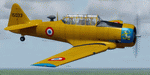
This folder contains a repaint for the A2A North American T-6 Texan/Harvard in the colors of North American T-6G s/n 51-5033 of the French Air Force EALA 11/72, La Reghaia, Algeria, 1960. The Marsupilami logo was a first attempt for the units logo, but it was only used on 3 aircraft before it was decided to go with a leopard logo. Repaint by Jan Kees Blom, based on the paintkit by A2A.
| Filename: | North_American_T6_Texan_15033_French_AF_EALA_1172.zip |
| License: | Freeware |
| Added: | 5th October 2019, 18:04:03 |
| Downloads: | 61 |
| Author: | Jan Kees Blom |
| Size: | 13.86 MB |
| Category: Prepar3D V1-4 - Aircraft Repaints, Textures and Modifications | |
| Republic P-47D-25 86th FG (11) "Miss Tennessee / Stump Lifter" |
|
Images related to this file:
File Description:

This folder contains a repaint for the P_47D-25 Bubbletop by Aeroplane Heaven, in the colors of P-47D-25-RA 42-8601 #11 "Stump Lifter", as flown by Lt Benny Flake of the 525th FS, 86th FG. The painting on the left hand side was of a moviestar, Marilyn Maxwell, with the name "Miss Tennessee". The name 'Stump Lifter' on the right side stems from that fact that one of Lt Flakes friends, Lt. Riley Stewart said that his bombs never hit their target and that all he ever saw during sorties with Lt Flake were large tree stumps flying through the air. Lt. Stewart paid the squadron's artist to put the "stump lifter" art on Lt Flake's cowling without his permission, but he came to like it over time. Repaint by Jan Kees Blom, based on the paintkit by Aeroplane Heaven.
| Filename: | Republic_P47D25_86th_FG_11_Miss_Tennessee__Stump_L.zip |
| License: | Freeware |
| Added: | 16th December 2018, 17:57:21 |
| Downloads: | 42 |
| Author: | Jan Kees Blom |
| Size: | 66.06 MB |


© 2001-2026 AVSIM Online
All Rights Reserved
Privacy Policy |