
Where Flight Simulation Enthusiasts Gather from Around the World!
AVSIM Library - Search Results

| Category: X-Plane - Aircraft Repaints, Textures and Modifications | |
| Eurowings Airbus A320 (Winglets) |

|
Images related to this file:
File Description:
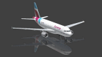
This is an X-Plane Eurowings A320 repaint for use with the payware A320 CFM by Peter Hager. Use the winglet model, this is an ex Air Berlin plane.
Some Information by Wikipedia: Eurowings GmbH is a German low-cost airline headquartered in Düsseldorf and a fully owned subsidiary of the Lufthansa Group. It serves a network of domestic and European destinations as well as some long-haul routes and maintains bases at Berlin Tegel Airport, Cologne Bonn Airport, Düsseldorf Airport, Hamburg Airport, and Vienna International Airport.
Eurowings has gone through a major transformation in recent years. It was part of Lufthansa Regional until October 2014. At that time it began operating on behalf of Germanwings within their network. Since spring 2015, Eurowings has been redeveloped into a low-cost carrier for short- and long-haul flights. By October 2015, it had also started to incorporate Germanwings' route network as part of the merger of the two brands.
| Filename: | Eurowings_Airbus_A320_Winglets.zip |
| License: | Freeware |
| Added: | 29th April 2017, 18:08:05 |
| Downloads: | 393 |
| Author: | Ralf Maylin |
| Size: | 12.91 MB |
| Category: Flight Simulator X - Gauges | |
| C-130 T.I.T. Gauge |
|
Images related to this file:
File Description:
This is an XML gauge that simulates the Turbine Inlet Temperature (T.I.T.) for Captain Sim's C-130 X-perience version 1.3 for FSX.
Note: All gauge click functions are accessed from the 2D gauge only.
Features included in this gauge:
- Simulated Turbine Inlet Temperature (T.I.T.)
- Virtual Cockpit installation
- Access to 2D panel via VC click-spot (Radio Stack)
- T.I.T. follow for Take-off, climb and cruise
- Display toggle (top): T.I.T., Cruise Ceiling and Current Elevator Trim
- Display toggle (bottom): Engine Torque, Engine Fuel Flow and True Airspeed (knots)
- T.I.T. follow will disconnect when altitude hold is selected and climb temperature is above 900°C
- Pre-defined selectable temperatures for T.I.T. follow: user selectable, 970°, 1010° and 1049°
- T.I.T. display will indicate T.I.T. follow is within ±2°C control during climb
- GTC sound fix for start-up, run and shut-down of Gas Turbine Compressor
| Filename: | C130_TIT_Gauge.zip |
| License: | Freeware, limited distribution |
| Added: | 21st August 2016, 20:28:29 |
| Downloads: | 441 |
| Author: | Paul Tally |
| Size: | 3.94 MB |
| Category: Flight Simulator 2004 - Aircraft Repaints, Textures and Modifications | |
| FS2004/P3D Qantas A350-1000ULR "Project Sunrise" |
|
Images related to this file:
File Description:

FS2004/P3D Qantas A350-1000ULR "Project Sunrise". Qantas Registration VH-OJA. This is a "fictional reg" at time of upload although heavily rumoured to be the reg # attached in honour of VH-OJA which was attached to Qantas's first 747-400 that set a record breaking 20 hour non-stop flight. 2 liveries included and repainted on TDS A350-1000 of Qantas's in the standard Qantas livery and a fictional "Project Sunrise" livery. The aircraft has some custom textures including custom passenger entry, custom fan blades, custom engine cowlings, custom Michelin Air-X tires. - Texture only. Included are 1024x1024 for FS9 and 2048x2048 for P3D. You will need to add to your existing TDS A350-1000 G2 model. For support with aircraft please visit Tenkuu Developers Studio's Facebook page: https://www.facebook.com/groups/tds350. Works in FS9 and P3D. Repaint by Phillip Hughes.
| Filename: | FS2004P3D_Qantas_A3501000ULR_Project_Sunrise.zip |
| License: | Freeware |
| Added: | 10th May 2026, 14:49:07 |
| Downloads: | 158 |
| Author: | TDS A350-1000 | Phillip Hughes |
| Size: | 43.81 MB |
| Category: Microsoft Flight Simulator (2020) - Aircraft Repaints, Textures and Modifications | |
| MF_P-38_Hollywood Hepcat |
|
Images related to this file:
File Description:
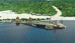
This folder contains a repaint for the Lockheed P-38L Lightning by Flying Iron. It shows Hollywood Hepcat' P-38J, numéro de série 42-31383, piloté par 2nd.
Le lieutenant Dwight M. Kelly, du 339th Fighter Squadron, 347th Fighter Group, 13th Air Force, en 1944, de Sterling Field dans les îles Salomon.
I was inspired by Ron Cole's magnificent painting: https://roncole.net/products/p-38-lightning-hollywood-hepcat-by-ron-cole?_pos=1&_sid=2b9efd2ac&_ss=r
where you can find superb painting on his site. https://roncole.net/
Repaint by Martial FÉRON, based on the textures by Flying Iron.
INSTALLATION
1. Unzip to a temporary location.
2. Copy the "MF_P-38_Holliwood Epcat" folder in this download to your "Community" folder in MSFS2020.
3. Have fun flying!
ACKNOWLEDGEMENTS
The model and textures used for this repaint were made by Fying Iron.
LEGAL STUFF
This repaint is released as FREEWARE. You may use and modify it in any way you wish, but
you may NOT use it in any kind of money-making endeavor, and you may NOT publicly
distribute any copies of it, whether modified or not, without my permission.
Martial FÉRON
CONTACT
Questions and/or comments about this repaint are always welcome via e-mail at [email protected].
April 2022
| Filename: | MF_P38_Hollywood_Hepcat.zip |
| License: | Freeware |
| Added: | 15th April 2022, 15:02:15 |
| Downloads: | 29 |
| Author: | Martial FÉRON |
| Size: | 56.72 MB |
| Category: Flight Simulator X - AFCAD Files | |
| Linden Airport (KLDJ), NJ v1.1 |
|
File Description:
Located 01 miles SE of Linden, New Jersey on 188 acres of land, Linden Airport is a public asphalt strip 4137' in length. Numerous changes have been made to this airport to bring it closer to its real-life counterpart including proper non-precision runway markings for R09 while only basic markings are used for R27; The 4-box VASI has been accurately located; the traffic pattern height has been adjusted; All 130 tiedown locations have been accurately placed. RAMP_GA spots are taken by static aircraft (all of which have collision disabled) so they should not be selected unless you want to start inside another aircraft! RAMP_GA_SMALL spots can be occupied by aircraft with wingspans up to 40 feet and RAMP_GA_MEDIUM spots can be occupied by aircraft with wingspans up to 60 feet. There are 4 open hangars labeled as GA_DOCK. The main hangar (NW Parking) can hold aircraft with wingspans up to 60 feet. The three smaller hangars (SW Parking) can hold aircraft with wingspans up to 35 feet. The W Helipad start location will put you in front of the smaller main tarmac hangar within the coned-off section. Fuel is only available by taxiing to a stop in front of either fuel tank to the west of the main tarmac. No AI aircraft will spawn in the SW Parking area.
Scenery constructed with use of satellite images/streetview/aerial photos - the author has not been there in person.
This scenery is meant to be used in conjunction with MegaScenery Earth New York 005. It is not required, but apron use is minimized to allow satellite scenery to show through as much as possible, and objects are placed based on the MSE textures - lack of it may make scenery look out of place.
| Filename: | Linden_Airport_KLDJ_NJ_v11.zip |
| License: | Freeware |
| Added: | 28th June 2011, 00:03:41 |
| Downloads: | 511 |
| Author: | Drew Sikora |
| Size: | 1.23 MB |
| Category: Flight Simulator 2004 - Scenery | |
| Kuujjuarapik CYGW in northern Quebec, Canada |
|
Images related to this file:
File Description:
Kuujjuarapik is in northern Quebec at the southern end of Hudson Bay, 90 miles east of James Bay and on the north shore of the Great Whale River; Kuujjuarapik means Small Great River in Inuktitut. Once again the Hudson Bay trading post that opened (in 1820) was the catalyst for the establishment of first a seasonal encampment and then the beginnings of a town in the late 1930's.
The two adjacent villages that now form the town have a total population (mainly Cree and Inuit) of around 1,500. When the Quebec hydo-electric project was under construction in the early 1980's a large portion of the Inuit population voted to move to a new settlement called Umiujaq (my post) 100 miles to the north.
The airport is to the west of the town, between the town and the sea. The gravel and sand runway (which I have made as gravel as there is no convincing way to mix the two) is 5,500 feet long, 150 feet wide, and aligned 17/35, which is approximately parallel to the coast. There is fuel available, both 100LL and JetA, delivered by truck. The AI included here is for Air Inuit and Wasaya, with Air Inuit making three flights per day plus a fourth flight by the Air Inuit Twotter C-GNDO that is based at the airport, and private flights by various aircraft. Yes, there really is a golf course to the south of the airport, and the last thing to note is that Kuujjuarapik has a mandatory radio frequency and that taking into consideration the scheduled flights I have included the tower radio frequency that makes this a controlled airport in FS9.
| Filename: | Kuujjuarapik_CYGW_in_northern_Quebec_Canada.zip |
| License: | Freeware, limited distribution |
| Added: | 16th February 2013, 00:33:20 |
| Downloads: | 306 |
| Author: | Roger Wensley |
| Size: | 2.8 MB |
| Category: Flight Simulator 2004 - Scenery | |
| Alaska South Slope 9; Wales IWK |
|
Images related to this file:
File Description:
There are four main northwestern Alaska towns which are serviced by Alaska Airlines, and from which local flights spread out. The northernmost is Barrow. Southwest of Barrow is Kotzebue, then Nome, and the furthest south is Bethel (not yet made). This is the second in a series for local flights from Nome, and it is on the furthermost mainland western point of Alaska, Wales IWK. It is 110 miles northwest of Nome and on the eastern shore of the Bering Strait, with a view of the two Diomede Islands. Wales is a small village with a population of only around 145, strung along the beach on a single road. The airfield is at the northwestern end of the village, with a runway of 4,500 feet of lit gravel aligned 35-17 and an apron at the southern end. There are scheduled flights by the usual Era and Bering Air, both of them originating in Nome and also visiting Shishmaref. The AI includes these flights along with Northern Air Cargo and GA. The runway is just long enough to accomodate a DC6 (as is Shishmaref) and I have revised the AI to include this, along with a revision of the parking at Shishmaref. To the southeast of Wales is Tin City, which was built as a base for the support of radar on the hills between the two. The radar is now automatic and unmanned and the base is unused except for the annual maintenance and fuel supply; I have left the airfield untouched but I have added the hilltop radar and the remains of the cable lift, which was used to get the material for the original station up to the top from the beach below.
| Filename: | Alaska_South_Slope_9_Wales_IWK.zip |
| License: | Freeware, limited distribution |
| Added: | 22nd October 2016, 01:26:24 |
| Downloads: | 570 |
| Author: | Roger Wensley |
| Size: | 3.77 MB |
| Category: Flight Simulator 2004 - Scenery | |
| Silver City CFQ5 in Yukon Territory Canada |
|
Images related to this file:
File Description:
Silver City is a ghost town in the Yukon Territory, Canada, amid the Rocky Mountains and around 35 miles northwest of Haines Junction. It is on the southern end of Kluane Lake and in the Kluane National Park and this probably explains it's (minimal) survival after what appears to have been the shutdown of mining for silver. There is little information readily available. The date of this scenery is, as usual, around 2010. There was no recent regular service by Yukon Air North or any other airline, and the primary user of the airfield adjacent to the lake is a company called Icefield Discovery Tours. Their activity is probably very similar to the company at Haines Junction and involves trips to the National Park amid mountains and glaciers. There is also another organisation at the airfield, the Kluane Lake Research Station of the Arctic Institute. They have four buildings there but it is unclear how much aerial activity they generate, or if in fact they fly at all for their work. The runway is 3,000 feet of unlit gravel, aligned north-south. This post will be followed by Burwash, which is at the far northwestern end of the lake. There is no video of the Silver City airfield on Youtube, and it is not the most exciting airfield in the world, but the location is enough in real life for a visit to be made. On YouTube there is a series of posts by Angle of Attack showing the preparation and then the flight of an old Cessna 172 from Homer to Oshkosh for the installation of modern instruments. Interesting for me as they visit or fly over airfields I have made: Homer, Merrill, Tok Junction, Burwash, Silver City, Haines Junction, Watson Lake, Fort Nelson, and Grande Prairie. But they fly in the winter so it all looks very different.
| Filename: | Silver_City_CFQ5_in_Yukon_Territory_Canada.zip |
| License: | Freeware, limited distribution |
| Added: | 22nd January 2022, 21:57:41 |
| Downloads: | 97 |
| Author: | Roger Wensley |
| Size: | 9.86 MB |
| Category: X-Plane - Original Aircraft | |
| B25 Mitchell Bomber |
|
File Description:
B25 Mitchell for X-Plane 6.40-6.6 Made famous by the Doolittle raid on Tokyo shortly after Pearl Harbour the B25 Mitchell bomber is the most famous medium bomber of WWII and perhaps of all time. The B25 was the most numerous twin engine aircraft built by the US during WWII; estimates of production vary from 9300 to 11000 built. On April 18, 1942 Doolittle led sixteen B-25 aircraft from the navy carrier, U.S.S. Hornet to bomb Japan in retaliation for that country's attack on Pearl Harbor on December 7, 1941. Although little damage was done and all planes were lost the raid proved to be one of the most famous missions of the war. The B25 was powered by a pair of 1,700 hp Wright R-2600-29 "Cyclone" 14 cylinder, air-cooled engines. Maximum speed was 272 mph at 15,000 ft, with a ceiling of 24,000 ft and a range of 1350 miles with a full load of bombs. Armament varied considerably in the B25 depending on the type of mission the plane was designed for. Heavenly Body is a B25J designed as a bomber, so it carried eleven 0.50 caliber machine guns; two in the top turret, two in the tail, one in the nose, two in cheek packs on each side under the pilot and one in each waste window. The top, nose and cheek pack guns could also be used in strafing, if so desired. This version carried 3,000 lbs of bombs (usually six 500 pounders) in an interior bomb bay. The X-Plane version is a fairly faithful rendition of the B25. The body consists of two sections consisting of the fuselage and a fuel tank. The main engine nacelles actually consist of two nacelles, one is the 1700 HP engine, the rear section is a 5 lb thrust rocket. Engine nacelles are also used for the two rudders in order to get the correct shape. Vertical stabilizers with rudders are buried within the nacelles. Decoration of the plane is complicated by the use of multiple nacelles but the resulting compromise is acceptable though not an authentic replica.
| Filename: | B25_Mitchell_Bomber.zip |
| License: | Freeware, limited distribution |
| Added: | 27th March 2003, 01:20:45 |
| Downloads: | 1,669 |
| Author: | Robert App |
| Size: | 1.37 MB |
| Category: Flight Simulator X - Scenery | |
| Mesh South America / MeSA E03 |
|
File Description:
FSX Mesh South America Project:
This terrain mesh file is a part of a whole project covering all the Continent
of South America and some islands, divided in tiles identified in a map by its
column (letters) and rows (numbers).
Those files were multi-LOD compiled from 90m SRTM2 source data, reprocessed
with 3DEM to remove voids and spikes, providing a 76.4m (LOD9) horizontal
resolution topography intended for use only in FSX updated with SP1.
Although not well documented, to improve performance, the updated FSX loads DEM
files in threads and only the closer terrain (about 5-10 NM from the point of view)
is rendered in high detail, while at far distances FSX shows up its default low
resolution mesh, when there is not a third part terrain mesh compiled in all
others intermediate level of details (multi-LOD).
THIS FILE:
FSX_MeSA_E03 (Column E x Row 03)
covers the area inside the boundaries:
N = 5º 37,5' N; S = 0º 0' S;
W = 60º 0' W; E = 52º 30' W;
| Filename: | Mesh_South_America__MeSA_E03.zip |
| License: | Freeware |
| Added: | 13th June 2007, 21:41:26 |
| Downloads: | 1,255 |
| Author: | Hely Heck Jr. and José Lôbo |
| Size: | 83.82 MB |


© 2001-2026 AVSIM Online
All Rights Reserved
Privacy Policy |