
Where Flight Simulation Enthusiasts Gather from Around the World!
AVSIM Library - Search Results

| Category: Flight Simulator 2004 - Scenery | |
| CWCY - Cape Young - Nunavut, Canada |

|
Images related to this file:
File Description:
Cape Young was a DEW line station on the nothern mainland coast 50 miles northwest of Kugluktuk, and 50 miles west of Lady Franklin Point. It closed in August 1993. Most of the buildings are still there, in various shades of decay. The runway is also still there and close to 5,000 feet of gravel in length, aligned and signed 110T/290T, though on the atc it will be called 07/25 as FS9 knows nothing about the Canadian Northern Domestic Airspace. There is no runway lighting, and don't be surprised if there are bushes growing amid the gravel.
| Filename: | CWCY__Cape_Young__Nunavut_Canada.zip |
| License: | Freeware, limited distribution |
| Added: | 11th November 2012, 01:23:51 |
| Downloads: | 223 |
| Author: | Roger Wensley |
| Size: | 1.53 MB |
| Category: Flight Simulator X - AFCAD Files | |
| Ellington FIeld - Houston, TX (KEFD) |
|
File Description:
This airport was requested by a fellow simmer, and it was so interesting, I had to do it. Aside from being a
civil airport, Ellington Field houses the Texas Air National Guard, the Texas Army National Guard, the US
Coast Guard, NASA, and also serves UPS.
I added Military_Cargo and Military_Combat parking spaces. I added the fire station and fire trucks. I moved
and replaced the control tower, removed and replaced many of the default buildings and added additional
buildings. Added static fork trucks, fuel trucks, parking lots with cars, NASA vehicles, and light poles.
Added, removed, or adjusted taxiways and aprons.
| Filename: | Ellington_FIeld__Houston_TX_KEFD.zip |
| License: | Freeware |
| Added: | 29th May 2008, 03:34:33 |
| Downloads: | 2,045 |
| Author: | Jim Cook |
| Size: | 19.92 KB |
| Category: Flight Simulator X - AFCAD Files | |
| EGAA - Belfast Intl. - Belfast, Northern Ireland |
|
Images related to this file:
File Description:
Belfast International Airport is a major airport located 21 km northwest of Belfast in Northern Ireland. It was formerly known and is still referred to as Aldergrove Airport, after the nearby village of Aldergrove, which lies immediately to the west of the airport. The airfield was previously shared with the Royal Air Force base RAF Aldergrove, which closed in 2008; the base is now known as Joint Helicopter Command Flying Station, Aldergrove, and both runways are now owned by the airport.
Using ADEx 1.55, aeronautical maps and Google Earth the default AFCAD has been completely reworked to reflect today´s situation.
| Filename: | EGAA__Belfast_Intl__Belfast_Northern_Ireland.zip |
| License: | Freeware |
| Added: | 19th March 2013, 11:05:23 |
| Downloads: | 901 |
| Author: | Menno C. Robert |
| Size: | 696.24 KB |
| Category: Prepar3D V1-4 - Scenery | |
| Courchevel Airport and city France N45.24.27 E6.34.39 |
|
File Description:
Courchevel Airport and city France N45.24.27 E6.34.39 at high altitude allows you to get to 4 Bellecote villages, Courchevel 1550 1650 and Courchevel 1850 or the tallest village and is the one that gives shine to Courchevel in the world, generally recognized as the most exclusive land skiing destination, even before places such as St Moritz. The highest point is located at the top of Saulire (2738 m asl) where there is the weather station "Sommet de la Saulire" N45.23.00 E6.36.37.
Within the downloaded package you will find readme files for scenery installation. Good fly VFR. Pasquale Marrulli.
| Filename: | Courchevel_Airport_and_city_France_N452427_E63439.zip |
| License: | Freeware |
| Added: | 5th January 2018, 16:40:14 |
| Downloads: | 1,366 |
| Author: | Pasquale Marrulli |
| Size: | 5.03 KB |
| Category: Flight Simulator X - Scenery | |
| LIML - Linate Airport - Milan, Italy |
|
Images related to this file:
File Description:
This airport update is for Linate airport: Airlines assigned to their gates as per their website with Gates/stands numbered correctly, both runways now corrected to 18/36 and 17/35 and the navaids corrected for them, taxiways and taxi signs updated to the latest charts with taxiway H now closed, PAPI for runway 18/36 now on both sides of the runway, new control tower, fire station, extra fuel trucks and many other scenery additions, airport views are from the roof of the control tower (when in tower view) please view the readme before installation.
| Filename: | LIML__Linate_Airport__Milan_Italy.zip |
| License: | Freeware, limited distribution |
| Added: | 9th May 2014, 06:37:59 |
| Downloads: | 25,814 |
| Author: | Craig Scott |
| Size: | 489.01 KB |
| Category: Flight Simulator X - Aircraft Repaints, Textures and Modifications | |
| Royal Netherlands Navy "098" UT-6 Harvard |
|
Images related to this file:
File Description:
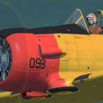
This packet includes a repaint of the Koninklijke Marine Luchtvaart Dienst
(Royal Netherlands Navy). The "098" was one of four UT-6 Harvards stationed
at De Kooy Naval Air Station in the Netherlands. They were used in the period
of 1965 till 1971 mainly for target towing missions.
The repaint is both on the outside and inside (cockpit & pilots) and features
also a modified bump-map.
To be used with the payware A2A Simulations T-6 TEXAN/HARVARD.
Buy it here: https://a2asimulations.com/
The A2A repaintkit was used for making this repaint.
| Filename: | Royal_Netherlands_Navy_098_UT6_Harvard.zip |
| License: | Freeware, limited distribution |
| Added: | 6th May 2016, 02:21:25 |
| Downloads: | 277 |
| Author: | Marcel Ritzema |
| Size: | 42.48 MB |
| Category: Flight Simulator X - Scenery | |
| KPWM - Portland Intl Jetport - Portland, Maine, USA |
|
Images related to this file:
File Description:
This airport update is made only for FSX with two optional files, one version with the Crosswind runway activated and in full operation where both runways will be used for takeoff and landing and one version as the default runway operation: airlines assigned to their correct gates, runway 18/36 now at its new lenghth, taxiways and taxi signs updated to the latest charts, terminal updated, extra fuel trucks, support vehicle roads rebuilt, fire station and many other scenery objects added, airport views are from the roof of the control tower (when in tower view) please view the readme before installation
| Filename: | KPWM__Portland_Intl_Jetport__Portland_Maine_USA.zip |
| License: | Freeware, limited distribution |
| Added: | 18th July 2014, 13:51:54 |
| Downloads: | 7,261 |
| Author: | Craig Scott |
| Size: | 548.82 KB |
| Category: Flight Simulator X - Scenery | |
| Joe Williams OLF - KNJW |
|
Images related to this file:
File Description:
Navy Joe Williams OLF is located in Meridian, MS and is approx 20 nm NW of Naval Air Station Meridian. Meridian NAS is home to Training Wing 1. TW-1 is comprised of VT-7 "Eagles" and VT-9 "Tigers" both flying the T-45C Goshawk. KNJW is used as an outlying field in order to take the traffic load away from NAS Meridian during periods of high density student training. This is the perfect place to practice your Field Carrier Landing Practice procedures as well as overhead approaches and emergency approach practice just like real student naval aviators!
| Filename: | Joe_Williams_OLF__KNJW.zip |
| License: | Freeware, limited distribution |
| Added: | 24th July 2011, 08:15:50 |
| Downloads: | 891 |
| Author: | Brandon Thetford |
| Size: | 25.79 MB |
| Category: Flight Simulator 2004 - Helicopters | |
| KOIN TV "Chopper Six" |
|
File Description:
This repaint depicts the paint scheme currently being used by Portland, Oregon TV station KOIN-TV Channel Six. This paint scheme has been in use for over five years. Hillsboro Aviation leases the helicopter to KOIN, and also provides the helicopter for KATU Channel 2, Portland, as well as a helicopter for aerial tours of the Mount St. Helens blast area. In 1998, KOIN Television and Portland-area Circuit City stores teamed up to market a 1:24 scale toy replica of Chopper Six, complete with working navigation beacons and spinning rotor blades. Requires Owen Hewitt's Bell JetRanger package.
| Filename: | KOIN_TV_Chopper_Six.zip |
| License: | Freeware |
| Added: | 16th August 2005, 03:35:11 |
| Downloads: | 223 |
| Author: | Steven Rosenow |
| Size: | 5.19 MB |
| Category: Flight Simulator X - Scenery | |
| KGTB - Wheeler-Sack AAF - Fort Drum, NY |
|
File Description:
Here is an improved version of the stock Wheeler-Sack AAF. I adjusted and added aprons, roads and
taxiways to more closely match real life. I added Military_combat and Military_cargo parking spaces.
I replaced most buildings and added additional buildings. I replaced and moved the control tower,
added the fire station, parking lots, static vehicles and helicopters, lightpoles, and other objects.
Fort Drum is home to the 10th Mountain Division and it houses an air-to-ground gunnery range which is
used by the 174th Fighter Wing of the NY National Guard out of Syracuse, NY.
| Filename: | KGTB__WheelerSack_AAF__Fort_Drum_NY.zip |
| License: | Freeware |
| Added: | 23rd April 2009, 06:48:06 |
| Downloads: | 903 |
| Author: | Jim Cook |
| Size: | 13.2 KB |
© 2001-2026 AVSIM Online
All Rights Reserved
Privacy Policy |