
Where Flight Simulation Enthusiasts Gather from Around the World!
AVSIM Library - Search Results

| Category: Flight Simulator 2004 - Aircraft Repaints, Textures and Modifications | |
| Mig 25 FOXBAT photoreal schemes |

|
Images related to this file:
File Description:
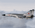
Re-uploaded photoreal repaints pack for the Alphasim Mig 25 FOXBAT.
It contains only Soviet air force colors: single seat grey, single seat camo
and 2 seaters grey inspired from MIG-25 'Foxbat' jetflight - to the 'Edge of Space' ( http://www.space-travellers.com/home/html/mig25.html )
- (see also http://www.bestrussiantour.com/tourfiles/temig25.htm ).
I've also reworked the VC, adding many details and joined a mod effects pack to use with the Alphasim payware Tu 160 BLACKJACK installed only, see the joined readme effects.txt
| Filename: | Mig_25_FOXBAT_photoreal_schemes.zip |
| License: | Freeware |
| Added: | 13th May 2010, 21:09:04 |
| Downloads: | 1,073 |
| Author: | Repaints by pierre lheureux - Plane by Alphasim |
| Size: | 5.07 MB |
| Category: Flight Simulator 2004 - Scenery | |
| LTFD2008v1.3 - Edremit Korfez Airport |
|
File Description:
----What's new with v1.3 ?
*PAPI added in accordance with the current charts
*Electric poles added on both sides of the runway in accordance with the current charts
*Static GA aircraft grouped as north(kuzey),west(batý) and east(dogu)
*Extra parking space created in the apron
*Door signs have been updated with the real signs
*Security towers added in vicinity of the field
*Also improvements and corrections have been made on the models
*Airfield's landclass updated(Fatih Koz)
Have safe flights.
| Filename: | LTFD2008v13__Edremit_Korfez_Airport.zip |
| License: | Freeware |
| Added: | 28th April 2008, 22:45:39 |
| Downloads: | 1,756 |
| Author: | Gökhan Bayrakdar |
| Size: | 7.81 MB |
| Category: Flight Simulator X - Scenery | |
| RAF North Creake |
|
File Description:
RAF North Creake is a former Royal Air Force station located 3.3 miles (5.3 km) southwest of Wells-next-the-Sea, Norfolk and 5.7 miles (9.2 km) northwest of Fakenham, Norfolk, England.
Originally used in 1941 as a decoy site for RAF Docking, construction of this Class A airfield began in October 1942, with the station being provided with accommodation for 2,951 male and 411 female staff. The airfield had 36 loop type hardstandings, two T2 hangars and one B1 hangar.
By December 1943 the airfield had passed to 100 Group, although it did not immediately become operational as consideration was given to upgrading the airfield to Very Heavy Bomber Standard. In the event, this did not take place, with RAF Sculthorpe being selected for upgrade.
Short Stirling III's from 199 Squadron arrived in May 1944 to complete Window and Mandrel operations against enemy radar tracking of Bomber Command raids, however, in March 1945 these were changed to Handley Page Halifax III's. In September 1944, No. 199's 'C' Flight was used to re-form 171 Squadron, who contributed to 100 Group's radio counter-measures activities with Halifaxes.
The RAF relinquished the station in 1947, and the area is now used for agriculture, though some evidence of runways, buildings and facilities remains. Seventeen aircraft were lost from the airfield, eight Stirling's and nine Halifax's.
The control tower survives, and has been converted into a house, offering bed and breakfast.
Source: Wikipedia
| Filename: | RAF_North_Creake.zip |
| License: | Freeware |
| Added: | 13th February 2016, 12:50:51 |
| Downloads: | 237 |
| Author: | Terry Boissel |
| Size: | 1.73 MB |
| Category: Flight Simulator 2004 - Scenery | |
| RAF Wittering 1990 |
|
Images related to this file:
File Description:

Wittering was opened as an RAF station in 1924, but flying here started way back in 1916 with the Royal Flying Corps.
Initially the Central Flying School was based here from 1926 until 1935. During World War 2, Wittering was a part of 12 Group, which was responsible for the defence of the Midlands.
The station took on a nuclear responsibility in 1956 with the arrival of the V-Force Valiants, and later Victor bombers. Because of this, the runway was increased in length.
After the V-Bombers left, the station took on the mantle of Home of the Harrier, a title it carried with it from 1969, until the stations closure in 2010.
This scenery is made up of various library objects, using ScruffyDuck's ADE9X, to make a close representation of the base, as opposed to being factually accurate.
Brian has incorporated most of the extra runways and representations of deck landing areas that were used at Wittering for V/STOL training - these runways are not active, but may still obviously be used for taking off and landing yourself.
Also included are repaints of John Young's Harrier GR3/T4 AI model, available from flightsim.com. These represent the aircraft of No.1(F) Squadron and No.233 OCU, during 1989-90.
There are also a set of representative flightplans to allow the Harriers to fly "typical" missions and flights.
| Filename: | RAF_Wittering_1990.zip |
| License: | Freeware, limited distribution |
| Added: | 6th October 2013, 17:17:42 |
| Downloads: | 1,392 |
| Author: | Brian Clarke, Daryl Payne |
| Size: | 20.58 MB |
| Category: Orbiter - Spaceships | |
| Explorer 1 Add-on for Orbiter |
|
File Description:
Explorer 1 was the first satellite launched by the United States when it was sent into space on January 31, 1958. Following the launch of the Soviet Union's Sputnik 1 on October 4, 1957, the U.S. Army Ballistic Missile Agency was directed to launch a satellite using its Jupiter C rocket developed under the direction of Dr. Wernher von Braun. The Jet Propulsion Laboratory received the assignment to design, build and operate the artificial satellite that would serve as the rocket's payload. JPL completed this job in less than three months.
The primary science instrument on Explorer 1 was a cosmic ray detector designed to measure the radiation environment in Earth orbit. Once in space this experiment, provided by Dr. James Van Allen of the State University of Iowa, revealed a much lower cosmic ray count than expected. Van Allen theorized that the instrument may have been saturated by very strong radiation from a belt of charged particles trapped in space by Earth's magnetic field. The existence of these radiation belts was confirmed by another U.S. satellite launched two months later, and they became known as the Van Allen Belts in honor of their discoverer.
Explorer 1 revolved around Earth in a looping orbit that took it as close as 354 kilometers (220 miles) to Earth and as far as 2,515 kilometers (1,563 miles). It made one orbit every 114.8 minutes, or a total of 12.54 orbits per day. The satellite itself was 203 centimeters (80 inches) long and 15.9 centimeters (6.25 inches) in diameter. Explorer 1 made its final transmission on May 23, 1958. It entered Earth's atmosphere and burned up on March 31, 1970, after more than 58,000 orbits. The satellite weighed 14 kilograms (30.8 pounds).
| Filename: | Explorer_1_Addon_for_Orbiter.zip |
| License: | Freeware |
| Added: | 27th September 2004, 16:24:14 |
| Downloads: | 1,258 |
| Author: | Jim Williams |
| Size: | 565.57 KB |
| Category: Flight Simulator X - Scenery | |
| RAF Manston 1944 |
|
File Description:
RAF Manston (ICAO EGMH)was an RAF station in the north-east of Kent, on the Isle of Thanet from 1916 until 1996. The site is now split between a commercial airport Kent International Airport (KIA) and a continuing military use by the Defence Fire Training and Development Centre (DFTDC), following on from a long-standing training facility for RAF firefighters at the Manston base.
Source: Wikipedia
I have represented it here in 1944 leading up to its part in Operation Market garden and D Day. It was one of the few airfields installed with the Fog Investigation Dispersal Organisation (FIDO) system designed to remove fog from airfields by burning it off with petrol and I have represented this with the 8 fuel tanks at the 29 end of the mail runway. I have laid the station out roughly according to an old map made in the mid 40s but I make no claims to the accuracy of building I have used.
| Filename: | RAF_Manston_1944.zip |
| License: | Freeware |
| Added: | 26th April 2016, 00:15:35 |
| Downloads: | 160 |
| Author: | Terry Boissel |
| Size: | 1.71 MB |
| Category: Flight Simulator X - Scenery | |
| RAF Ludford Magna |
|
File Description:
RAF Ludford Magna was a Royal Air Force airfield operated by Bomber Command during the Second World War and the Cold War. The station lay on agricultural farmland immediately south of the village of Ludford, Lincolnshire and was sited 21.4miles (34.4 km) north east of the county town of Lincoln, Lincolnshire, England. The remains of the station can be seen from the B1225 Caistor High Street, and the long distance footpath the Viking Way passes right next to the eastern perimeter track.
It was the highest bomber airfield in England at 428 feet (130 m) above sea level, and cost £803,000 to build.
All credit must go to the following authors without whose work I could not have made this scenery; all credit for the models contained in it is theirs I merely placed it. If you don't have any of the third party addons you will only see the runway and peri track: Ted Andrews - Ian Pearson - Mike Hudson
| Filename: | RAF_Ludford_Magna.zip |
| License: | Freeware |
| Added: | 5th October 2015, 20:07:32 |
| Downloads: | 339 |
| Author: | Terry Boissel |
| Size: | 20.9 KB |
| Category: Flight Simulator X - Scenery | |
| RAF Moreton In The Marsh - Gloucestershire, England |
|
File Description:
RAF Moreton-in-Marsh was a Royal Air Force station near Moreton-in-Marsh, Gloucestershire. It was opened in November 1940 and closed for operational flying in early 1948. The base remained in use as a relief runway and for training. After a period of care and maintenance, the Station was handed over to the Home Office in 1955.
The town's environs are quite flat and low-lying although it is situated at the northern extremity of the Cotswold Hills range. During World War II, a large area of this flat land to the east of the town was developed as an airfield and became the base of 21 OTU (Operational Training Unit) RAF, flying mainly Vickers Wellington bombers. It is highly likely that the airfield inspired the title of the radio show Much Binding in the Marsh. After all, two of its stars, Kenneth Horne and Richard Murdoch, served there as flying instructors.
| Filename: | RAF_Moreton_In_The_Marsh__Gloucestershire_England.zip |
| License: | Freeware |
| Added: | 1st February 2016, 10:07:46 |
| Downloads: | 227 |
| Author: | Terry Boissel |
| Size: | 1.74 MB |
| Category: Flight Simulator 2004 - Scenery | |
| Calcinate del Pesce, Italy |
|
Images related to this file:
File Description:
Calcinate del Pesce is a small gliders airport placed on Varese lake, approx 25 miles north-west Milan Italy, closed to the Prealpi hills. North of the hills around you can find towers and observer of Campo dei Fiori meteo station. The airport is also base of Elilombarda, helicopter-rescue. Contents: Grass runway placed approx on the real coordinates, with ILS and taxi ways; five different hangars and fast food on the entrance; 10 gliders parked on the ground, several glider boxes all around the airport; a lot of trees around the scenery and lights on parking, gliders and road areas; wind sign, static Cessna, fuel station, people and cars; bird storm floating in the air; complete fences on all the airport perimeter with opening gate; two helicopters on ground and a Coca Cola balloon; small pier in the lake with dinghy; Varese open footbal stadium, close sport building and cathedral (fiction); Campo dei Fiori fantasy scenery with observe and comunication towers
| Filename: | Calcinate_del_Pesce_Italy.zip |
| License: | Freeware |
| Added: | 16th February 2011, 15:34:22 |
| Downloads: | 767 |
| Author: | Aldo Della Vedova |
| Size: | 12.28 MB |
| Category: Miscellaneous Files - Miscellaneous Files | |
| Wee Tune Beastie for Sky Blue Radio! |
|
File Description:
Wee Tune Beastie (WTB) is a tray application that is designed to run with minimal processing resources. The SBR variant offers quick and easy play of Sky Blue Radio Radio via broadband connection either as a standalone player or as an add-on tool that will launch play whenever your Com2 player in Flight Simulator is tuned to the pre-described frequency in the manual. WTB is a quick and fun way to listening to Sky Blue Radio Radio without the need to load any additional applications or visit the website itselft. WTB is also a fun way to create the illusion of tuning a real radio station in your cockpit during flight. The author and SBR hope that you enjoy this free product as we have and will experience many hours of enjoyment using the application and listening to Sky Blue Radio Radio - the *only* radio station dedicated to the Flight Simulation Community.
www.skyblueradio.com
| Filename: | Wee_Tune_Beastie_for_Sky_Blue_Radio.zip |
| License: | Freeware |
| Added: | 1st April 2009, 07:08:56 |
| Downloads: | 252 |
| Author: | Richard Rudd, Davon Leslie |
| Size: | 1.08 MB |


© 2001-2026 AVSIM Online
All Rights Reserved
Privacy Policy |