
Where Flight Simulation Enthusiasts Gather from Around the World!
AVSIM Library - Search Results

| Category: Flight Simulator 2004 - AFCAD Files | |
| La Guardia |

|
File Description:
A high quality AFCAD2 file the New York La Guardia (KLGA) scenery by Shehryar Ansari. This file features assigned gates for all airlines that currently serve LGA. In order to ensure only 'mainline' aircraft use the jetbridges, a new 'Express' apron for Dash 8 and RJ size aircraft is provided near the Central Terminal and also adjacent to the US Air and Delta Terminals. An extensive GA parking area has also been added to the west side of the airport and includes 4 Helipads. A tower view is provided for the airport and both runways are also in use to maximize traffic flow. The Marine Terminal (Delta Shuttle) and US Airways (Shuttle) areas now have seperate parking codes. The txt for these codes is included in this zip, to add to your 'ParkingSpecs' document. Every available space at this airport has been used to provide a total of 140 parking positions, comprising 42 gates for regional jets, 59 gates for mainline aircraft, 4 Cargo Ramps and 35 GA ramps. A very easy to use tutorial explaining how to make AI Delta Shuttle aircraft use only the Marine Terminal and US Air Shuttle aircraft only use the US Shuttle Terminal is included. This package also includes screenshots showing the effects that this file has on your AI traffic. Requires the excellent scenery addon LGA2004.zip by Shehryar Ansari. This file is not recommended to be used with the default FS airport.
| Filename: | La_Guardia.zip |
| License: | Freeware |
| Added: | 1st February 2005, 04:51:36 |
| Downloads: | 8,784 |
| Author: | Lee Brompton |
| Size: | 4.2 MB |
| Category: Flight Simulator X - Scenery | |
| YEEB Eneabba, Western Australia strip and townsite |
|
File Description:
YEEB Eneabba strip and townsite
Sand mining town in heart of wildflower area Located 278 km north from Perth via the Brand Highway, Eneabba is basically a sand mining town surrounded by some of the most extensive and spectacular wild flower displays anywhere in Western Australia. The town itself is, to be fair, a real non-event with dreary modern housing (with more than a hint of construction town design), a small shopping centre and a service station all of which look as though they have sprung up in the last 20-30 years. The wealth of the area is based on the rutile sands which lie to the south of the town as well as farming, particularly cattle grazing. With an estimated 80 per cent of the world's known rutile supplies the town can boast that it has the biggest deposits of rutile in both Australia and the world. The major mining company in the area is Iluka Resources Ltd. Eneabba is basically a service town for the mines but some of the miners, realising that Eneabba is hardly a paradise, have opted for commuting and live on the coast at Leeman and drive to work preferring the beach to the dry inland.
REQUIRES blencowe_librarykit_309494.zip (Available HERE)
| Filename: | YEEB_Eneabba_Western_Australia_strip_and_townsite.zip |
| License: | Freeware |
| Added: | 25th February 2013, 23:48:24 |
| Downloads: | 255 |
| Author: | Alan Blencowe |
| Size: | 3.59 MB |
| Category: Flight Simulator 2004 - Scenery | |
| Cedar Lake Logging Camp |
|
File Description:
After flying my first real life solo flight I decided to celebrate by making a fun scenery for flightsim. Cedar Lake Logging Camp was designed to be a great destination for Northern Ontario (Canada) Bush pilots. It is situated northwest of Dryden. It has one 1800 foot gravel runway with trees on both sides for challenging approaches and takeoffs, a helipad and a dock for float operations (visible). There are several cabins on site as well as a hanger and fuel station on the gravel apron. There is a fuel barge and cargo crates by the float docks. For the bush atmosphere there are several deer in the area, a tractor pulling a mower by the runway, and two static aircraft (a Piper Cub by the hanger and a Cessna 185 on floats at the fuel barge). An AI aircraft is integrated into the file as well - the piper cub flies to Red Lake in the morning and to Dryden in the afternoon. There is also an integrated AFCAD file so the camp will show up in the flight simulator database and in the GPS. There are 5 starting locations including the runway ends, 2 parking spots on the apron, the helipad, and beside the dock. I hope you enjoy this as much as I will.
| Filename: | Cedar_Lake_Logging_Camp.zip |
| License: | Freeware, limited distribution |
| Added: | 19th February 2004, 01:33:22 |
| Downloads: | 2,121 |
| Author: | David Voogd |
| Size: | 2.69 MB |
| Category: Flight Simulator X - Scenery | |
| RAF Hooton Park - Cheshire, England |
|
File Description:
RAF Hooton Park, on the Wirral Peninsula, Cheshire, was a Royal Air Force station originally built for the Royal Flying Corps in 1917 as a training aerodrome for pilots in World War I. During the early/mid-1930s, it was one of the two airfields (with Liverpool Speke) handling scheduled services for the Merseyside region. Hooton Park was home to No. 610 (County of Chester) Squadron and, post World War II, to No. 611 (West Lancashire) and No. 663 (AOP) Squadron.
The airfield closed in 1957 after the disbandment of the Royal Auxiliary Air Force, but the three pairs of Belfast Truss hangars erected in 1917 survived the closure. The site was bought by Vauxhall Motors, who built their Vauxhall Ellesmere Port plant there, which today produces the Vauxhall Astra. A small remaining section of the airfield site is now owned and managed by The Hooton Park Trust. The hangars are also home to The Griffin Trust and an aircraft preservation society named The Aeroplane Collection. Another part of the old airfield, including a length of the old paved runway, perimeter track and the apron used to park Meteor jet fighters, remains in the ownership of The Naylor Trust. A Second World War B1 hangar is also on this site.
Third party add-on's will be required see the readme.txt for details.
| Filename: | RAF_Hooton_Park___Cheshire_England.zip |
| License: | Freeware |
| Added: | 13th December 2015, 12:12:02 |
| Downloads: | 195 |
| Author: | Terry Boissel |
| Size: | 1.47 MB |
| Category: Microsoft Flight Simulator (2020) - Scenery | |
| UGAM Ambrolauri Airport, Georgia [MSFS] |
|
Images related to this file:
File Description:
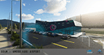
Ambrolauri Ambrolauri (Georgian: áƒáƒ›áƒ‘რáƒáƒšáƒáƒ£áƒ ი) is a city in Georgia, located in the western part of the country, on both banks of the Rioni river, at the elevation of 550 m above sea level. It is a self-governing city. At the same time, the city serves as the seat of the Racha-Lechkhumi and Kvemo Svaneti regional administration and the Ambrolauri Municipality. According to the 2014 census, the city had a population of 2,047. Its area is 1.6 km². Ambrolauri is first recorded in the 17th century as a place, where one of the palaces of the kings of Imereti was located. It acquired the city status in 1966 and became a self-governing city with its own municipal government in 2014. The Airport The airport is nestled into the Caucasus mountains right at the bank of the river Rioni. It has a single runway of 1100 m length and caters small propeller aeroplanes. The apron has space for two planes at a time and caters up to 50 passengers at one time. In the Simulator The virtual airport is very close to its real-world counterpart. All the buildings at and near the airport are modelled and the terminal even has an interior that can be seen from outside. The look and feel from a trip to the Racha region is definitely there. In real life, only small planes fly to the airport but that shouldn't stop you to bring planes from the size of the Dash 8.
| Filename: | UGAM_Ambrolauri_Airport_Georgia_MSFS.zip |
| License: | Freeware, limited distribution |
| Added: | 30th December 2020, 18:16:07 |
| Downloads: | 179 |
| Author: | David Hilker |
| Size: | 72.32 MB |
| Category: Flight Simulator 2004 - Scenery | |
| Big Creek U60 public use airfield in Idaho USA |
|
File Description:
This airfield is in the mountains of Idaho, 30 miles south of Dixie A05, which was the first in the series to be posted. Big Creek is now regularly used for picnic fly-ins and overnight camping, or for just a day of fishing in the creek; the creek does not appear in FS9 as it is not exactly huge, and within the Ultimate Terrain USA settings I have in fact turned streams off as in some cases they cross the grass or (in conjunction with the roads) left insufficient runway space. The U60 runway is at 5,743 feet ASl, 3,550 feet long, aligned 01-19, and in good condition. At the southern end there is the new replica of the old original Big Creek Lodge which was built in 1935. This burned down in 2008, and is now being rebuilt by a group of pilots, pilots having formed a large part of the early clientel courtesy of the grass strip. It is shown here as still under construction. There are also Forest Service buildings on the west side of the runway. All of this is located in the Frank Church Wilderness area and the Payette National Forest. The AI is increased at the weekends, reflecting reality, and also revised to use Boise as one of the starting places. Dixie is also reissued here with a revised positioning to fit with the roads. I had concluded that the roads were wrong, while in fact the position of the airstrip was at fault.
| Filename: | Big_Creek_U60_public_use_airfield_in_Idaho_USA.zip |
| License: | Freeware, limited distribution |
| Added: | 25th May 2017, 17:53:58 |
| Downloads: | 132 |
| Author: | Roger Wensley |
| Size: | 11.06 MB |
| Category: X-Plane - Original Aircraft | |
| Black Cat Catalina PBY5/5Av1.1 for x-plane |
|
File Description:
This update includes improvements to the fuselage shape, addition of retractable wing floats using wheel farings, an improved but not custom panel, improved prop efficiency and more. The PBY Catalina is probably the best known flying boat with over 4000 produced by Consolidated aircraft and licensees. The Black Cat squadrons all done in flat black played havoc particularly for the Japanese in the Pacific. Fitted with radar, with a 15 hour endurance and 2800 mile range they hunted Japanese naval ships by night and bombed or torpedoed them by the hundreds up. There are 6 engine nacelles used in the model, 2 represent the 1200 HP radial engines driving the props, the others are jets with 5 lbs of thrust, 1 is used for the rear fuselage section, 1 is used for the wing pylon, 1 is used for the flare from the fuselage to the vertical stabilizer and the last is used for the forward observation and gunner space. Two are not used. Wing sections are taken up by the main wing and the support spars so there you go. The fuel tanks are used for the side gunner pods since these can be decorated separately. The plane flies very well and is stable as a rock. Takeoffs from water are quite easy as long as you don't dip a wing tip (no floats remember). The Black Cat squadron logo used in the paint scheme is courtesy of http://www.daveswarbirds.com/blackcat/logos.htm and is from the VP-71 Black Cat squadron.
| Filename: | Black_Cat_Catalina_PBY55Av11_for_xplane.zip |
| License: | Freeware, limited distribution |
| Added: | 9th March 2003, 22:48:18 |
| Downloads: | 1,218 |
| Author: | Robert App |
| Size: | 136.75 KB |
| Category: Flight Simulator 2004 - Scenery | |
| CYYQ - Churchill Port & York Factory - Northern Manitoba, Canada |
|
Images related to this file:
File Description:
The main part of this scenery installs the Port of Churchill and the grain silos. Churchill CYYQ has been made by Sidney Schwartz, and this also adds AI and slightly modifies his parking to make a space big enough for Buffalo's C46. Churchill is in northern Manitoba, on the Churchill River where it empties into Hudson Bay. The town is accesible by air, by boat (once the winter ice melts) and most importantly by rail from the south. Grain from the Canadian prairies is hauled north and stored in Churchill for export to Europe by a sea route that is significantly shorter than any other, and there is a grain carrier included in the AI. Today there are perhaps 810 people living in Churchill, a slowly declining number. There are also a number of impressive polar bears. There was another port south of Churchill, but it was never completed, never connected to a railroad track, and never used. It was called Port Nelson, and was at the mouth of the Nelson River. Nearby, on the Hayes River, there is an old trading post called York Factory, built in 1684 and preserved as part of the living history of the north of Canada. The second scenery is for this, and for the nearby tourist camp called Silver Goose Lodge, which as the name suggests is for hunters. The large grassy area alongside the fort was for the trappers to camp on when they all arrived in early summer to trade the furs for goods.
| Filename: | CYYQ__Churchill_Port__York_Factory__Northern_Manit.zip |
| License: | Freeware, limited distribution |
| Added: | 23rd July 2014, 02:26:04 |
| Downloads: | 545 |
| Author: | Roger Wensley |
| Size: | 3.69 MB |
| Category: Flight Simulator 2004 - Scenery | |
| KLBB - Lubbock Preston Smith Intl - Texas V3.0.1 |
|
Images related to this file:
File Description:

Lubbock is another one of those little known, neglected airports that populate the
FS world. Avery simple airport, LBB somewhat feels like a little DFW. There is a very DFW-ish main terminal with fewer than
10 gates and plenty of space to grow. The only mainline service is courtesy Southwest, but several RJ's freqent Lubbock
several times per day along with the big freighters. This airport was built from the ground up with excellent detail,
and because of the sparse traffic, frame rates are excellent as well.
V2.0 Update:
Recently, Lubbock has moved their east-west runway 8/26 roughly 1000 feet to the East so as to eliminate runway incursions
by separation from the north-south runway 17R-35L. Version 2.0 reflects this modificaton. Several taxiways have been removed
or modified, and airport fencing has been altered to reflect the change.
V3.0 Update:
This update fixes some major errors mainly on the West side of the airport. The cargo ramp and some of the GA parking had been
found to be located in the wrong positions. They have been relocated and rebuilt to match GoogleEarth images. Also, the afcad
has been updated to line up with these changes along with airline parking updates at the main terminal. All the jetways have
been replaced with more accurate representations, and they have also been adjusted to match their current real world positioning.
v3.0.1 update:
There was a missing scenery library that has been added to the download, so now the jetways will appear if they had not before.
| Filename: | KLBB__Lubbock_Preston_Smith_Intl__Texas__V301.zip |
| License: | Freeware |
| Added: | 18th May 2013, 07:39:35 |
| Downloads: | 1,551 |
| Author: | FRFStudio.net / William Morgan |
| Size: | 8.17 MB |
| Category: Flight Simulator X - Scenery | |
| RAF Elvington |
|
File Description:
The station was originally a grass airfield within No. 4 Group. In the early 1940s the airfield was entirely reconstructed with three hardened runways replacing the grass. It re-opened in October 1942 as a station for 77 Squadron RAF and along with RAF Melbourne and RAF Pocklington was known as No "42 Base". The squadron had a strength of approximately 20 aircraft and initially used the twin engined Armstrong Whitworth Whitley medium bomber although this was quickly replaced by the Handley Page Halifax four engined heavy bomber which was being introduced. No 77 Squadron suffered heavy losses during its time at Elvington with over 500 aircrew killed, missing or taken prisoner and almost 80 Halifaxes lost as it played a major part in the Battle of the Ruhr and the bombing of Berlin.
In May 1944 No 77 Squadron posted to the newly opened nearby RAF Full Sutton and was replaced at Elvington by two French squadrons, numbers 346 "Guyenne" and 347 "Tunisie" who both played a leading part in the bombing of Germany. Elvington was the only airfield in the United Kingdom used by the remainder of the Free French Forces, they also flew Handley Page Halifax heavy bombers until they moved to Bordeaux in October 1945 where they became the basis for the new air force of liberated France. In September 1957 a memorial was unveiled in Elvington village dedicated to the two French squadrons. While they were at RAF Elvington nearly half of the squadrons' members were killed.
After the war the 400-acre (1.6 km2) airfield was transferred to No 40 Group under the control of Maintenance Command until 1952 when it was greatly enlarged and extended for use by the United States Air Force.
United States Air Force use
The United States Air Force (USAF) built a new 3,094 m (10,151 ft) runway, which was the longest in the north of England, and a huge 19.8 hectares (49 acres) rectangular hardstanding apron as well as a new control tower to turn Elvington into a "Basic Operation Platform" which would have operated as a Strategic Air Command (SAC) dispersal airfield. After spending £4 million the airfield never became operational as a SAC base and was abandoned by the US Air Force in 1958.
Other uses
In the early 1960s the Blackburn Aircraft Company, now part of British Aerospace used the runway for test flights of the Blackburn Buccaneer. Elvington retained its status as an RAF relief landing ground and was used by the RAF flying training schools at RAF Church Fenton and RAF Linton-on-Ouse until the airfield was finally closed in March 1992.
Present day
The airfield is now owned by Elvington Park Ltd. The adjacent buildings and control tower have been restored, and serve as the Yorkshire Air Museum which has many varied and rare aircraft and exhibits, including a complete Halifax bomber. Elvington is also a popular motorsports venue for motorcycle racing.
Source:Wikipedia
| Filename: | RAF_Elvington.zip |
| License: | Freeware |
| Added: | 10th April 2017, 22:08:13 |
| Downloads: | 167 |
| Author: | Terry Boissel |
| Size: | 220.79 KB |
© 2001-2026 AVSIM Online
All Rights Reserved
Privacy Policy |