
Where Flight Simulation Enthusiasts Gather from Around the World!
AVSIM Library - Search Results

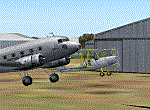
| Category: Flight Simulator X - Scenery | |
| Silloth Aerodrome plus Great Orton |

|
File Description:
RAF Station Silloth is a former Royal Air Force station located 1 mile (1.6 km) north-east of Silloth, Cumbria, England and 6.7 miles (10.8 km) south-west of Kirkbride, Cumbria. The station was used by RAF Coastal Command during WW2.
I designed this scenery primarily for my own pleasure using Airport Design Editor and FSX SDK. I use FSX Acceleration and Horizon VFR photo scenery but it should work with standard FSX SP2.
This scenery depicts the airfield as closely as i can get it with the available information. I have modelled all of the Airfield buildings as closely as I could with the information available to me and this was done using Sketchup, the models were then converted for use in FSX using Model converter X.
It is not 100% accurate and no claim is being made by the author that it is. I have depicted the buildings in wartime camo.
All the buildings can be used as as you wish. My only request is that if you should design better textures for them that you let me have a copy, my textures are pretty basic.
Some buildings have night lighting, lights and smoke effects, these should be in your FSX effects files already.
I have not yet completed the Domestic Site but i may do this in the future...(I've hit the buffers for now though!!)
Included in this scenery pack is the Satellite Airfield RAF Great Orton. Built in 1943 to accommodate the larger bombers now being used by the RAF. This airfield is very sparse as i am unable to get much info about it.
Runways, Taxiways, Watch Office and Ground Signals are all that is included in this scenery pack, along with Sloped flattens, crosswind runways and AGN files.
I have included this as a destination for the Bristol Beaufort AI aircraft that i have included with the scenery.
The Bristol Beaufort AI is a freeware model from Alphasim and is used with their permission. I have altered the model textures and aircraft file and it works well enough as AI.
I have used other scenery libraries within this scenery (mainly to depict the village of Silloth) and these will need to be downloaded from the appropriate sources and activated within FSX.
| Filename: | Silloth_Aerodrome_plus_Great_Orton.zip |
| License: | Freeware |
| Added: | 6th December 2015, 22:32:18 |
| Downloads: | 491 |
| Author: | Mark Byers |
| Size: | 357.87 MB |
| Category: Flight Simulator X - Flight Plans | |
| Amazon´s Deadly Road |
|
File Description:
A Brazilian Air Force C-130 from SAR Squadron 504 has been sent to the Port of Máraba
where it will receive instructions to fly over road BR-230 by the river and pick up all drivers
along the road due to recently formed "Wells of Gas" which are believed to be highly toxic.
Also, an airliner crashed a few hours ago and survivors must be quickly taken to a hospital.
Many people in the area are sure that there is a "machine" in the largest gas pool!!!! some even
suggest it could be an invasion from outer space!!!!!! so the flight will take pictures of this site as
a top secret priority. All personnel will be on a week long "Secret Mission Status". You must leave
everything right away and head to base!!!!!..go man, go.
| Filename: | Amazons_Deadly_Road.zip |
| License: | Freeware, limited distribution |
| Added: | 8th January 2008, 21:41:09 |
| Downloads: | 1,364 |
| Author: | Gera Godoy C |
| Size: | 197.66 KB |
| Category: Flight Simulator 2004 - AFCAD Files | |
| A&F Data For South Australia airfields v2 |
|
Images related to this file:
File Description:
This updated set of 76 AFCAD2 files are for use with the free add-on scenery from Roger Leupold (fs9sav1.zip) are not suitable for the default FS2004 airfields. Version 2 incorporates corrected ICAO codes using the excellent listing made available by Mal Lloyd. The files will allow the scenery (designed for FS2002) to become more useable in FS2004. They will allow you to plan routes, and take off and land at some 76 airfields featuring in the scenery, with ATC routing you appropriately. AI aircraft can now land, taxi, park and take off in the correct locations, and you can introduce your own AI traffic, too, if you wish. Every airfield has at least one parking space (even the tiniest airstips) but airfields featuring hangers and other scenery have more. [File re-uploaded at request of AVSIM]
| Filename: | AF_Data_For_South_Australia_airfields_v2.zip |
| License: | Freeware |
| Added: | 26th May 2010, 19:14:18 |
| Downloads: | 435 |
| Author: | John Hinson |
| Size: | 84.15 KB |
| Category: Flight Simulator X - AFCAD Files | |
| Pemberton Airport (3N7), NJ |
|
File Description:
Located 01 miles NW of Pemberton, New Jersey on 14 acres of land, Pemberton Airport is a private airstrip. Tie down areas are available at the Runway 22 end. The single parking space is a tie down - do not use if your aircraft's wingspan is greater than 50 feet. Note that the actual listing for this airport in real world databases is 3NJ1. Trees are summertime ONLY.
Scenery constructed with use of satellite images/streetview, the author has not been there in person.
This scenery is meant to be used in conjunction with MegaScenery Earth New Jersey/Delaware 002. It is not required, but apron use is minimized to allow satellite scenery to show through as much as possible, and objects are placed based on the MSE textures - lack of it may make scenery look out of place.
| Filename: | Pemberton_Airport_3N7_NJ.zip |
| License: | Freeware |
| Added: | 23rd November 2010, 22:32:59 |
| Downloads: | 184 |
| Author: | Drew Sikora |
| Size: | 1.12 MB |
| Category: Flight Simulator 2004 - Scenery | |
| Los Angeles Virtual Terminal 2009 |
|
File Description:
The LAX Vterminal was originally released to a select few virtual airlines. These were West Express,
Atlantic Sun, Empora Virtual, City Bird, Arizona Pacific, and Family Virtual Airlines. The terminal
contains three concourses, forty-three (43) gates, and eight overflow parking spots. Parking assignments
have not been assigned to any of the gates, so you will need to go through and do so.
The terminal was created by Michael Wood and Nick O'Dell. It was designed to fit the needs of virtual
airlines, in order to return parking spots in the main terminal to their real world owners. This
scenery is frame rate friendly, and will not take up a lot of space on your hard drive. Included in
this file are AFCAD's for the default and OceanFlight scenery.
Enjoy our scenery, and look for more scenery projects coming in the near future.
| Filename: | Los_Angeles_Virtual_Terminal_2009.zip |
| License: | Freeware, limited distribution |
| Added: | 11th March 2009, 08:40:06 |
| Downloads: | 563 |
| Author: | Nick O'Dell, Michael Wood |
| Size: | 232.46 KB |
| Category: Flight Simulator 2004 - Scenery | |
| The Bermudas Islands |
|
Images related to this file:
File Description:

The Bermudas islands are located in the middle Atlantic. Their main island is in the 32 15 71 N and 64 52 50 W.Is a very broken into fragments island that it is part of s cluster of 150 islands distributed in an area of 53 square kms
This archipielago like superior vertex together with Puerto Rico island and the city of Lauderade-Hollywood in Florida U.S.A. tey form the celebrates TRIANGLE OF BERMUDAS that in the time 50 ships and 20 airplanes have disappeared. Most of these disappareances they can be explained, other nr.
Nevertheless to the one West of the island and a near a carrier to 2000-3000
feet high approximately I have discovery some ships floating in the space.
Not you if they are part of the disappareances....But they are there.
Discover it your same one....
| Filename: | The_Bermudas_Islands.zip |
| License: | Freeware |
| Added: | 8th November 2010, 04:31:29 |
| Downloads: | 1,808 |
| Author: | Toni Agramont |
| Size: | 14 MB |
| Category: Flight Simulator X - Scenery | |
| Alaska Airfields 1.2 |
|
Images related to this file:
File Description:
This is a pack of three airfields in Alaska that I have modified to look more like the real thing. The scenery is made of ready made library buildings and trees, no custom made buildings and stuff, but it's a vast improvement over the stock FSX airfields. The three Airfields are (CSR) Campbell Airfield, (PAUO) Willow Airfield and (PASW) Skwentna Airfield. PLEASE NOTE: These scenerys are made with FSX Acceleration and Flight 1's Ultimate Alaska X installed. I don't know how they look or work without these add-ons. - In version 1.2 I have added a segmented circle to PAUO Willow Airfield (a small make-up), and I have also added a Dock parking space at 2X2 Willow Sea Plane Base, so you may start your flight at the dock with your float or ski plane (a big change). -
| Filename: | Alaska_Airfields_12.zip |
| License: | Freeware |
| Added: | 12th February 2012, 03:46:53 |
| Downloads: | 3,300 |
| Author: | Torbjorn Kuntze |
| Size: | 1.94 MB |
| Category: Flight Simulator 2004 - Scenery | |
| Europe SRTM mesh part 10: Lower Danube |
|
File Description:
Europe SRTM LOD9 mesh part 10 of 13: Covers a wide area centered over the Danube valley from Novi Sad to the Black Sea (42°N-46°N, 19°E-30°E). Includes Balkans & Transylvanian moutain ranges, and parts of the following countries: Romania, Bulgaria, Serbia and Albania.
This Europe SRTM project was optimized for the lowest HDD space use: Each part macthing exactly the boundaries of its neighbors, you'll have a complete corevage of Europe without gap or overlapping scenery. Based on SRTM Data v1 and v2 (3 arcsec, 90m) and sampled to LOD9 resolution (76m). Each SRTM tile was carefully checked and repaired with Blackart v4.02: water areas are now flattened (lighter mesh), and SRTM voids were treated taking advantage of Blackart's sophisticated interpolation algorithm. When required, biggest voids were patched with oversampled SRTM 30 arcsec data and/or manual input.
| Filename: | Europe_SRTM_mesh_part_10_Lower_Danube.zip |
| License: | Freeware, limited distribution |
| Added: | 19th October 2005, 17:55:10 |
| Downloads: | 11,734 |
| Author: | Yohann Baptiste |
| Size: | 39.14 MB |
| Category: Flight Simulator 2004 - Scenery | |
| Groom Lake Area 51 (NV51) |
|
File Description:
Secret Military base in Rachel, Nevada where supposed to be a secret underground part that studies and test airplanes and other flying craft. It also is known to do outer space things and has several alien in there base. This base was redone with satelite images with exact apron, runway, taxiway, lighting and parking. I redid this from TJ Synkral's Area 51 and used everything that was not included in his. I also added the helicopter area. This is sutable for AI with what ever airline you want. I recommend getting the Janet Airlines AI and regular aircraft you can fly on FlightSim.com It might be here on avsim, im not sure. Enjoy
I would like to ask if anyone could redo this with buildings on it where it is on the background satelite i would like that
| Filename: | Groom_Lake_Area_51_NV51.zip |
| License: | Freeware |
| Added: | 25th March 2006, 03:16:09 |
| Downloads: | 2,094 |
| Author: | James Hudson, TJ Synkral |
| Size: | 2.4 MB |
| Category: Flight Simulator 2004 - Scenery | |
| Europe SRTM mesh part 01: LOD7 buffer mesh |
|
File Description:
Europe SRTM LOD9 mesh part 1 of 13: This is a LOD7 mesh covering the whole Europe from 35°N to 60°N and 12°W to 30°E, to be used as a buffer mesh in conjection with the LOD9 mesh. This Europe SRTM project was optimized for the lowest HDD space use: Each part macthing exactly the boundaries of its neighbors, you'll have a complete corevage of Europe without gap or overlapping scenery. Based on SRTM Data v1 and v2 (3 arcsec, 90m) and sampled to LOD7 resolution (300m). Each SRTM tile was carefully checked and repaired with Blackart v4.02: water areas are now flattened (lighter mesh), and SRTM voids were treated taking advantage of Blackart's sophisticated interpolation algorithm. When required, biggest voids were patched with oversampled SRTM 30 arcsec data and/or manual input.
| Filename: | Europe_SRTM_mesh_part_01_LOD7_buffer_mesh.zip |
| License: | Freeware, limited distribution |
| Added: | 19th October 2005, 16:11:05 |
| Downloads: | 19,063 |
| Author: | Yohann Baptiste |
| Size: | 50.28 MB |
© 2001-2026 AVSIM Online
All Rights Reserved
Privacy Policy |