
Where Flight Simulation Enthusiasts Gather from Around the World!
AVSIM Library - Search Results

| Category: Flight Simulator 2004 - Scenery | |
| Princess Juliana Int'l (TNCM) |

|
Images related to this file:
File Description:
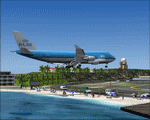
Princess Juliana Int'l Airport, v1.2. Scenery of TNCM, Princess Juliana International Airport of St-Maarten in the Netherlands Antilles. Adds an ILS on runway 9 though in reality Juliana airport is not equipped with this instrument. Adds the weather station, cars on the airport parking, extends the hill near Maho hotel and adds the Juliana heliport. By Delblond Christian.
| Filename: | Princess_Juliana_Intl_TNCM.zip |
| License: | Freeware |
| Added: | 8th June 2022, 00:35:24 |
| Downloads: | 724 |
| Author: | Delblond Christian |
| Size: | 4.76 MB |
| Category: Flight Simulator 2004 - Scenery | |
| Houston William P. Hobby Airport |
|
File Description:
Detailed scenery for Houston Hobby Airport, Houston, Texas, USA. Houston Hobby Airport is a medium-sized airport which serves as one of the main hubs for Southwest Airlines. The airport also caters to the corporate and general aviation traffic for Houston.
This version is the high-resolution detailed version. A normal resolution less detailed version will be uploaded separately.
| Filename: | Houston_William_P_Hobby_Airport.zip |
| License: | Freeware, limited distribution |
| Added: | 10th May 2008, 09:18:11 |
| Downloads: | 8,398 |
| Author: | Shehryar Ansari |
| Size: | 47.4 MB |
| Category: Flight Simulator 2004 - Scenery | |
| Alaska North Slope 10; Kivalina KVL in Alaska |
|
Images related to this file:
File Description:
The town of Barrow is in the far north of Alaska, and these are coastal villages or radar installations to the west, south, and east of Barrow on the North Slope. There will be further additions. Kivalina is a small village (population around 350) midway in the 150 mile gap between Point Hope to the north and Kotzebue to the south. The village is on a spit of land that is growing smaller and smaller with every year of erosion and the rise of sea level. The runway is 3,500 feet of gravel aligned 12-30 to the north of the village on the same spit. It was expected that 2025 would see the end of both village and runway, and possibly also the natural harbour that is the reason for the village's location. The modified width of the spit shown here is halved from the original FS9, and erosion has continued, enough that a sea defence wall has now been built. The AI has a daily flight by an ERA Alaska Cessna 208B, and some GA; read the note about the 208 to be downloaded and/or properly installed.
| Filename: | Alaska_North_Slope_10_Kivalina_KVL_in_Alaska.zip |
| License: | Freeware, limited distribution |
| Added: | 27th July 2016, 21:12:15 |
| Downloads: | 245 |
| Author: | Roger Wensley |
| Size: | 2.87 MB |
| Category: Flight Simulator 2004 - Scenery | |
| Alaska South Slope 6; Shungnak SHG |
|
Images related to this file:
File Description:
There are four main northwestern Alaska towns which are serviced by Alaska Airlines, and from which local flights spread out. The northernmost is Barrow. Southwest of Barrow is Kotzebue, then Nome, and the furthest south is Bethel (not yet made). This is a continuation of the series for the flights from Kotzebue, 150 miles to the east where Shungnak is on the bank of the Kobuk River. The next addition will be a few miles further east, Kobuk and a strip just to the north of Kobuk. Shungnak is a small village, like Ambler, with a population of around 260 beside the Kobuk River, the river being the reason for the existance of the villages as it served (and still does) as both a source of food and a transport route. The airfield is just beside the village, with a runway around 4,000 feet of lit gravel and aligned 09-27, with PAPI on both ends. There are scheduled flights by Era (now renamed Ravn) and by Bering Air, both of them originating in Kotzebue and routing east to Ambler, Shungnak, Kobuk, and then back again. The AI includes these flights along with Everts Air and GA.
| Filename: | Alaska_South_Slope_6_Shungnak_SHG.zip |
| License: | Freeware, limited distribution |
| Added: | 12th October 2016, 23:18:32 |
| Downloads: | 211 |
| Author: | Roger Wensley |
| Size: | 1.99 MB |
| Category: Flight Simulator 2004 - Scenery | |
| Binghamton Airport |
|
File Description:
FS2004 Scenery - Greater Binghamton Airport (IATA: BGM, ICAO: KBGM) is a medium-sized regional airport located in Maine, New York that serves the Southern Tier of New York, primarily Broome and Tioga counties. The airport was originally named Broome County Airport and that name remained through the 1970s. It was later renamed to honor the inventor of the aircraft instrument simulator, the Link Trainer, as Edwin A. Link Field-Broome County Airport, a name it kept until the 1990s when it was again renamed to the Binghamton Regional Airport. The name Greater Binghamton Airport was chosen in 2003 to match the area's new marketing campaign under a unified name. The field on which the airport lies is still named in Link's honor. Created using EZ Scenery by John B. Loney, Jr.
| Filename: | Binghamton_Airport.zip |
| License: | Freeware, limited distribution |
| Added: | 14th September 2007, 01:35:27 |
| Downloads: | 1,346 |
| Author: | John B. Loney, Jr. |
| Size: | 814.98 KB |
| Category: Fly! II - Scenery | |
| Atlantic City International Airport (KACY) |
|
File Description:
TerraModels Scenery Development System by Allen Kriesman, Biber Salsa and Steves models were used to create the airport scenery for Atlantic City International Airport (KACY), New Jersey.
| Filename: | Atlantic_City_International_Airport_KACY.zip |
| License: | Freeware |
| Added: | 24th November 2005, 06:53:16 |
| Downloads: | 252 |
| Author: | Wayne Roberts |
| Size: | 801.62 KB |
| Category: Fly! II - Miscellaneous Files | |
| Connecticut Flight Plan |
|
File Description:
This Connecticut flight adventure starts at the Chester Airport (3B9) and ends at the Meridan Markham Municipal Airport KMMK). There are 8 airports in this flight plan.
| Filename: | Connecticut_Flight_Plan.zip |
| License: | Freeware |
| Added: | 27th August 2006, 02:25:24 |
| Downloads: | 38 |
| Author: | Wayne Roberts |
| Size: | 58.02 KB |
| Category: Flight Simulator X - AFCAD Files | |
| PHPA - Port Allen Airport - Kauai |
|
File Description:
Island of Kauai in Hawaii. Port Allen Airport. Additional parking spot and hangar. WARNING!!! See Readme - Any AI Traffic - Airport ICAO need modify - PAK change to PHPA
| Filename: | PHPA__Port_Allen_Airport__Kauai.zip |
| License: | Freeware |
| Added: | 30th March 2011, 01:12:48 |
| Downloads: | 399 |
| Author: | Gilbert Bowers |
| Size: | 3.76 KB |
| Category: Flight Simulator X - Scenery | |
| HKEL v2, Eldoret International Airport, Kenya |
|
Images related to this file:
File Description:
Updated. Eldoret Internatiobnal Airport services three scheduled international cargo flights and several ad hoc freighters per week. The airport promotes the exploitation of tourism in Western Kenya.
| Filename: | HKEL_v2_Eldoret_International_Airport_Kenya.zip |
| License: | Freeware |
| Added: | 8th April 2018, 01:38:36 |
| Downloads: | 1,238 |
| Author: | Tim van Ringen |
| Size: | 2.72 MB |
| Category: Flight Simulator X - AFCAD Files | |
| Prince Abdul Majeed bin Abdulaziz Domestic Airport (OEAO) - Al-Ula, Saudi Arabia |
|
File Description:
A basic AFCAD for Prince Abdul Majeed bin Abdulaziz Domestic Airport, a new airport which opened in October 2011. Includes parking, tower, terminal building, and VOR/DME.
| Filename: | Prince_Abdul_Majeed_bin_Abdulaziz_Domestic_Airport.zip |
| License: | Freeware, limited distribution |
| Added: | 2nd April 2017, 18:01:06 |
| Downloads: | 329 |
| Author: | Paul Anderson |
| Size: | 2.13 KB |


© 2001-2026 AVSIM Online
All Rights Reserved
Privacy Policy |