
Where Flight Simulation Enthusiasts Gather from Around the World!
AVSIM Library - Search Results

| Category: Flight Simulator 2002 - Scenery | |
| Ilha da Trindade Airport |

|
File Description:
FS2002 ILHA DA TRINDADE AIRPORT. Part 1 of 4 of the FS2002 BRAZILIAN ISLANDS FICTIONAL AIRPORT SET 2003 V1.0.
Scenery of fictional Ilha Trindade Airport including Navaids, AFCAD and AI Traffic. Ilha Trindade is an isolated Brazilian Atlantic Island and has a permanent inhabited Brazilian Scientific Military Base (POIT).
| Filename: | Ilha_da_Trindade_Airport.zip |
| License: | Check within download |
| Added: | 3rd November 2003, 23:53:55 |
| Downloads: | 204 |
| Author: | Roland Flommer |
| Size: | 419.57 KB |
| Category: Flight Simulator X - Flight Plans | |
| iFly 737NG Flight Plan Tampa International Airport - Armstrong International Airport |
|
File Description:
This file contains information for the route for a flight between
Tampa, Florida and New Orleans, Lousisiana
for the iFly 737NG using the following airports: Tampa International Airport and
Departure:Tampa International Airport
IATA:TPA
ICAO:KTPA
WMO:72211
Destination: Louis Armstrong International Airport
IATA:MSY
ICAO:KMSY
FAA LID: MSY
WMO:72231
| Filename: | iFly_737NG_Flight_Plan_Tampa_International_Airport.zip |
| License: | Freeware |
| Added: | 25th March 2025, 18:13:12 |
| Downloads: | 4 |
| Author: | David M. Long |
| Size: | 2.16 KB |
| Category: Flight Simulator X - Scenery | |
| Prince Abdul Majeed Bin Abdulaziz Airport OEAO Alula Saudi Arabia |
|
Images related to this file:
File Description:
Prince Abdul Majeed Bin Abdulaziz Airport OEAO Alula Saudi Arabia scenery not FSX stock airport ,adds Terminal
,Fire and rescue with Tower station , 1 apron for 3 aircrafts
numbered in the correct order,The airport updated to reflect current satellite imagery and positioning ,
it should work for p3d
| Filename: | Prince_Abdul_Majeed_Bin_Abdulaziz_Airport_OEAO_Alu.zip |
| License: | Freeware |
| Added: | 25th December 2018, 21:11:08 |
| Downloads: | 573 |
| Author: | Mohamed Salamoni |
| Size: | 7.28 MB |
| Category: Flight Simulator X - AFCAD Files | |
| MMSP Ponciano Arriaga Intl Airport - San Luis Potosi, Mexico |
|
File Description:
This scenery updates MMSP Ponciano Arriaga Intl Airport. The stock airport has been modified making it more realistic and up-to-date. The scenery was created using the awesome scenery tool Airport Design Editor by Scruffyduck Software. Please refer to the readme file for more details and installation instructions.
| Filename: | MMSP_Ponciano_Arriaga_Intl_Airport__San_Luis_Potos.zip |
| License: | Freeware |
| Added: | 29th May 2019, 01:38:24 |
| Downloads: | 329 |
| Author: | David Midgett |
| Size: | 1.54 MB |
| Category: Flight Simulator 2004 - Scenery | |
| Laguna del Sauce Airport, Punta del Este (SULS), Uruguay |
|
Images related to this file:
File Description:
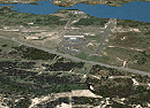
Photorealistic scenery of Laguna del Sauce / Curbelo (SULS) International Airport in Maldonado, Uruguay, version 1. This is the airport that serves the well-known beach resort of Punta del Este. This scenery package includes the airport facilities with the passenger terminal, general aviation area and the naval airbase on the banks of Laguna del Sauce lake. Several buildings and vehicles belonging to the airport have been recreated. Also included is the area around the airport recreated as photorealistic terrain with seasonal variations at a 4. 75 m/pixel resolution. Certain parts of the airport have been recreated with a 2 m/pixel photorealistic terrain. The aim of this scenery is to simulate flying to and around the airport under instrument flight rules (IFR) and also visual flight rules (VFR).
| Filename: | Laguna_del_Sauce_Airport_Punta_del_Este_SULS_Urugu.zip |
| License: | Freeware |
| Added: | 9th June 2010, 02:48:12 |
| Downloads: | 1,473 |
| Author: | "A Vuelo de Pajaro" / "As the Bird Flies" Design Group members: Diego Altgenug, Daniel Gazzano, Alan Pereira Pierce, Juan Pablo Simonet |
| Size: | 13.81 MB |
| Category: Flight Simulator 2004 - Scenery | |
| CYQR 2015 - Regina International Airport - Groome Field |
|
Images related to this file:
File Description:

Regina International Airport can trace its history back to 1919, when Regina airport became the first registered "air harbour" in Canada. This virtual model of CYQR represents the airport as it was in spring of 2015. CYQR airport is the gateway to southern Saskatchewan, Canada and is situated in Regina, which is the provincial capital. The airport is served by Air Canada, Air Canada Express, Westjet, Westjet Encore, West Wind Aviation, Express Air, Sunwing, Air Transat, Cargojet and Delta Airlines. The airport is named for Roland Groome, who was the first registered pilot in Canada.
This scenery was constructed with GMAX and includes detailed models of all buildings on the airport property. The scenery also includes the major landmark buildings of the City of Regina and those on the Runway approaches.
| Filename: | CYQR_2015__Regina_International_Airport__Groome_Fi.zip |
| License: | Freeware, limited distribution |
| Added: | 12th August 2015, 00:51:35 |
| Downloads: | 2,826 |
| Author: | Gregory Putz |
| Size: | 183.45 MB |
| Category: Flight Simulator 2004 - Scenery | |
| Zion National Park North, Cedar Breaks National Monument, Cedar City (KCDC), Utah, Photo-Scenery (FS9 & FSX) |
|
Images related to this file:
File Description:
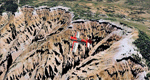
Cedar Breaks National Monument is a large amphitheater cliff in bright colors of red, orange and purple.
It lies east of Cedar City in the northern region of the scenery. The cliff was formed by erosion thru wind,
water and ice. Today erosion continues with a pace of about 2 inches every 5 years. Although it is called
Cedar Breaks, there are no cedars growing there but juniper trees. For a scenic flight to Cedar Breaks
National Monument best depart from Cedar City Regional Airport (KCDC) and head east. The scenery extends
south to Zion National Park and covers a large part of Zion Canyon and the Kolob Canyons area.
Zion National Park is another place where erosion of the Colorado Plateau formed the most beautiful colorful
stone formations of unique and wonderful shapes. There are nine different layers of stone visible in the park.
Most of them consist of sandstone. But there is also limestone, gypsum, siltstone, shale, clay and mudstone.
The Virgin River cut a spectacular and famous canyon thru Zion Park that is as narrow as 20ft and up to 2000ft tall.
High resolution versions of this scenery for FS9 and FSX (much sharper, but larger and multiple downloads)
are available at www.blueskyscenery.com/CNY_South2West5.html . The screenies are taken from the high-res versions,
so expect this version to be slightly more blurry.
Thanks to Joop Mak for providing a custom AFCADs that correct airport layouts so that they align with the photo-textures!
They are available here: www.blueskyscenery.com/AFCADs.html . YourDonation@Work: Dedicated to Richard, P.J. and Felix.
| Filename: | Zion_National_Park_North_Cedar_Breaks_National_Mon.zip |
| License: | Freeware, limited distribution |
| Added: | 14th March 2010, 00:30:28 |
| Downloads: | 1,566 |
| Author: | Gottfried Razek - blueskyscenery.com |
| Size: | 97.13 MB |
| Category: Prepar3D V1-4 - Scenery | |
| Lokpriya Gopinath Bordoloi International Airport Guwahati VEGT P3Dv4 |
|
Images related to this file:
File Description:
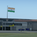
Lokpriya Gopinath Bordoloi Airport (IATA: GAU, ICAO: VEGT), also known as Guwahati Airport and formerly as 'Borjhar Airport', is the primary airport of the North-Eastern states of India. It is the 11th busiest airport in India. It is located at Borjhar, 26 km (16 mi) from Dispur, the capital city of the state of Assam and 28 km (18 mi) from Guwahati and is named after Late Gopinath Bordoloi, a freedom fighter and the first Chief Minister of Assam after India's independence. The airport is managed by Airports Authority of India and also serves as an Indian Air Force base.
Special Thanks to Ron Baruah for his VEGT Terminal Models, MFSG and MisterX for Vehicle Libs, Mayukh Deb for MD Libs and Taxi Lighting, Sriharsha K for Gate Signboards and Lightpoles and many more!
Compatible with Prepar3D v4.
| Filename: | Lokpriya_Gopinath_Bordoloi_International_Airport_G.zip |
| License: | Freeware |
| Added: | 15th June 2021, 18:55:10 |
| Downloads: | 612 |
| Author: | Saurabh Bansal |
| Size: | 257.15 MB |
| Category: Prepar3D V5 - Scenery | |
| Lokpriya Gopinath Bordoloi International Airport Guwahati VEGT P3Dv5 |
|
Images related to this file:
File Description:
Lokpriya Gopinath Bordoloi Airport (IATA: GAU, ICAO: VEGT), also known as Guwahati Airport and formerly as 'Borjhar Airport', is the primary airport of the North-Eastern states of India. It is the 11th busiest airport in India. It is located at Borjhar, 26 km (16 mi) from Dispur, the capital city of the state of Assam and 28 km (18 mi) from Guwahati and is named after Late Gopinath Bordoloi, a freedom fighter and the first Chief Minister of Assam after India's independence. The airport is managed by Airports Authority of India and also serves as an Indian Air Force base.
Special Thanks to Ron Baruah for his VEGT Terminal Models, MFSG and MisterX for Vehicle Libs, Mayukh Deb for MD Libs and Taxi Lighting, Sriharsha K for Gate Signboards and Lightpoles and many more!
Compatible with Prepar3D v5.
| Filename: | Lokpriya_Gopinath_Bordoloi_International_Airport_G.zip |
| License: | Freeware |
| Added: | 15th June 2021, 18:55:37 |
| Downloads: | 277 |
| Author: | Saurabh Bansal |
| Size: | 257.18 MB |
| Category: Flight Simulator X - Scenery | |
| KMFV - Accomack County Airport - Melfa, Virginia, USA |
|
Images related to this file:
File Description:
Accomack County Airport (IATA: MFV, ICAO: KMFV) is a county-owned public-use airport located 1 mile (1.6 km) west of the central business district of Melfa. The airport was built by the United States Army Air Forces about 1942, and was known as Melfa Flight Strip. It was an emergency landing airfield for military aircraft on training flights. It was closed after World War II, and was turned over for local government use by the War Assets Administration (WAA).
This is a complete re-work of the airport with added taxiways, parking and custom buildings. Created with Airport Design Editor by ScruffyDuck Software using current FAA documentation and Google Earth measurements, this package offers a replacement for FSX's stock airport. All these enhancements are as close to the real airport as I can get with stock library objects and custom buildings.
| Filename: | KMFV__Accomack_County_Airport__Melfa_Virginia_USA.zip |
| License: | Freeware |
| Added: | 16th February 2015, 11:56:40 |
| Downloads: | 429 |
| Author: | Wayne Roberts |
| Size: | 292.84 KB |


© 2001-2026 AVSIM Online
All Rights Reserved
Privacy Policy |