
Where Flight Simulation Enthusiasts Gather from Around the World!
AVSIM Library - Search Results

| Category: Flight Simulator X - Missions | |
| NormandieTour3.zip |

|
File Description:
Intermediate helicopter mission. This is tour three (3) of three aerial excursions in the Normandy region of France. Requires one additional scenery download, unless you have downloaded it already from the either of the first two missions. Instructions are included in the zip package.
| Filename: | NormandieTour3zip.zip |
| License: | Freeware |
| Added: | 4th September 2020, 18:48:16 |
| Downloads: | 96 |
| Author: | Helomissionman |
| Size: | 9.47 MB |
| Category: Flight Simulator X - Missions | |
| AlsaceTour4.zip |
|
File Description:
Intermediate helicopter mission. Take passengers on an aerial tour of the Alsace region of France. This is tour 4 of 4. Requires an additional download of the Alsace scenery if you did not get it for tour 1,2,or 3. Instructions in the zip file.
| Filename: | AlsaceTour4zip.zip |
| License: | Freeware |
| Added: | 2nd October 2020, 18:26:48 |
| Downloads: | 96 |
| Author: | helomissionman |
| Size: | 11.37 MB |
| Category: Flight Simulator X - Missions | |
| BretagneTour3.zip |
|
File Description:
Intermediate helicopter mission. Take passengers on an aerial tour of the Bretagne region of France. This is tour (3) of three. Mission requires one additional download of scenery if you didn't get it for tour 1 or 2. See instructions in the zip package.
| Filename: | BretagneTour3zip.zip |
| License: | Freeware |
| Added: | 19th November 2020, 19:42:43 |
| Downloads: | 76 |
| Author: | helomissionman |
| Size: | 12.87 MB |
| Category: Flight Simulator 2004 - Scenery | |
| Fourth of July Fireworks Part 2 |
|
File Description:
This scenery will add Fourth of July Fireworks to the following cities: Bangor, Portland(me), Concord(nh), Manchester(nh), Burlington(vt), Montpelier, Hartford, Providence, Albany, Syracuse, Harrisburg, Erie, Dover, Trenton,
Baltimore, Charleston(wva), Richmond, Raliegh, Charlotte, Columbia, Charleston(sc), Savannah, Jacksonville, Tallahassee, Pensacola, Mobile, Birmingham,
Jackson(ms), Knoxville, Memphis, Louisville, Chatham(ma), Provincetown(ma), Marthas Vinyard, Nantucket, and San Antonio.
| Filename: | Fourth_of_July_Fireworks_Part_2.zip |
| License: | Freeware |
| Added: | 6th June 2006, 01:06:32 |
| Downloads: | 938 |
| Author: | Gregg Wolfram |
| Size: | 57.94 KB |
| Category: Flight Simulator X - Aircraft Repaints, Textures and Modifications | |
| Republic (Texas) Douglas DC-9-10 |
|
Images related to this file:
File Description:
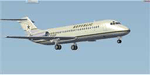
Textures only for the HJG McDonnell Douglas DC-9-10 JT8D-1 v1.14. Republic (of Texas) is a fantasy airline offering low cost service
(using DC-9 aircraft) from Austin Bergstrom to many cities in Texas (and to Las Vegas). Requires installation of the Historic Jetliners Group
aircraft. AI traffic file supplied for putting the airline into service in FSX (only).
| Filename: | Republic_Texas_Douglas_DC910.zip |
| License: | Freeware, limited distribution |
| Added: | 11th April 2014, 03:25:02 |
| Downloads: | 72 |
| Author: | Dan French |
| Size: | 1.82 MB |
| Category: Flight Simulator 2004 - AI Flight Plans | |
| Phoebus Apollo Aviation Winter 2008 |
|
File Description:
Winter 2008 flightplans for Phoebus Apollo Aviation - Congo Branch (Johannesburg - South Africa).
Fleet is: 1 McDonnell Douglas DC9-32.
Phoebus Apollo Aviation is a South African carrier with a branch operating flights between cities from Congo (Brazzaville, Ouesso, Pointe Noire and Impfongo)
Repaint: (On Avsim.com)
DC93 -> zs-pak.zip by Uwe Hoffmann.
Afcad/Scenery: (Avsim.com)
Look for afcad files by Florian Kreuzer.
| Filename: | Phoebus_Apollo_Aviation_Winter_2008.zip |
| License: | Freeware |
| Added: | 29th November 2008, 15:51:17 |
| Downloads: | 622 |
| Author: | Francois Massin |
| Size: | 4.79 KB |
| Category: Flight Simulator X - Scenery | |
| LJLJ - Jozef Puchnik International Airport - Ljubljana, Slovenia |
|
Images related to this file:
File Description:
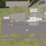
Decent representation of Slovenian airport named after Jozef Pucnik,
located near the village Spodnji Brnik, some 15 miles north of Slovenia's capital Ljubljana.
The scenery is packed with many features: custom landclass in the walley underlying the approach paths to both runways(12 and 30),
custom airport layout as found after last reconstruction of aprons and taxiways, corrected approaches (so IFR AI traffic in case of a missed approach to runway 30 is no longer turning right crashing into the 8000ft mountains just North of the airport). All airport buildings are placed into their correct
locations and shapes, even if only default generic buildings and library objects were used.
You will also notice airport has 3 runways(AFCAD on steroids),when there is actually
only one in reality and only one is also visible in the simulation.
This was done in order to enable different categories of AI aircraft using different intersections
for departure and the only way possible to recreate this was to use overlayed runways of different lenght.
There are also some surprises hidden in the scenery, but we will leave them for you to discover.
Music titles used in the scenery are published with kind permission of the author, Mr.Slavko Avsenik.
Released as freeware but with limited distribution.
LJLJ2012 by SST - Slovenia Scenery Team
| Filename: | LJLJ__Jozef_Puchnik_International_Airport__Ljublja.zip |
| License: | Freeware, limited distribution |
| Added: | 10th June 2012, 15:30:05 |
| Downloads: | 3,475 |
| Author: | SST - Slovenia Scenery Team |
| Size: | 11.35 MB |
| Category: Flight Simulator X - AFCAD Files | |
| KLVN - Airlake Airport - Lakeville, MN, USA |
|
File Description:
KLVN - Airlake Airport beta version .3 - by Jason Boche
This is an update of the default FSX KLVN airport. Aside from the original 12/30 runway, everything else at this airport has been completely ripped and replaced.
Enhancements include:
-Extended runway on each end to depict current configuration
-Accurate taxiways including Hamburg Ave. and buildings representing the current general aviation hangars
-Added navigational equipment on the field
-Added a few asphault and dirt service roads
-Added FBO and other buildings as close as I could match them
-Added some general aviation aircraft, civilians, vehicles at the FBO and hangars, and two fuel trucks
-Moved fuel station to where I believe it is currently according to Google maps with 100LL fuel trigger functional
-Moved the windsock to accurate location
-Moved the beacon to accurate location
-Moved GA parking spots
-Added trees around FBO and beacon
-Added utility poles
-Added a few square miles of Lakeville city, farm, and residential land class and autogen according to Google maps. This is probably the biggest improvement. It now looks like people live, work, and shop north/northwest of KLVN.
-Reworked the runway 12/30 blast pads to what I believe is the "proper" method. Instead of freehand polygon asphault, they are now actual runway extensions on both ends with yellow chevron markings
-Reworked the land class on the southwest end of the airport where I believe hangar expansion is intended. Prior to this, there was a sharp contrast between where the KLVN airport boundary ended and where generic farm landclass began which was right in the middle of the southwest taxiways and it looked bad. Now that whole region is grass and looks to be part of the airport parcel.
-Minor building adjustments west of the FBO to better match actual placement. Will only be shown on high scenery detail.
-Fixed a gap on the southeast end of Hamburg ave taxiway where it rounds the corner for the rwy 30 hold short line
-Randomized the directional facing of some of the cars parked at GA hangars
-Renumbered the parking spots 1-4 with #5 being the refueling spot
-Reversed the start direction of parking spots 1-3.
-Pulled the refueling parking "start" spot back because on start the engine cowling & prop were too far forward inside the fuel pump equipment
-Added an autogen exclusion to the rwy 12 short final due to trees popping up on short final path.
-KLVN tower viewpoint 25 meters above FBO.
-Removed the perimeter fence around the entire field
| Filename: | KLVN__Airlake_Airport__Lakeville_MN_USA.zip |
| License: | Freeware |
| Added: | 22nd November 2013, 23:26:10 |
| Downloads: | 225 |
| Author: | Jason Boche |
| Size: | 446.33 KB |
| Category: Prepar3D V1-4 - Scenery | |
| KLVN - Airlake Airport - Lakeville, MN, USA |
|
File Description:
KLVN - Airlake Airport beta version .4 - by Jason Boche
This is an update of the default P3Dv4.5 KLVN airport. Aside from the original 12/30 runway, everything else at this airport has been completely ripped and replaced.
Enhancements include:
-Extended runway on each end to depict current configuration
-Accurate taxiways including Hamburg Ave. and buildings representing the current general aviation hangars
-Added navigational equipment on the field
-Added a few asphault and dirt service roads
-Added FBO and other buildings as close as I could match them
-Added some general aviation aircraft, civilians, vehicles at the FBO and hangars, and two fuel trucks
-Moved fuel station to where I believe it is currently according to Google maps with 100LL fuel trigger functional
-Moved the windsock to accurate location
-Moved the beacon to accurate location
-Moved GA parking spots
-Added trees around FBO and beacon
-Added utility poles
-Added a few square miles of Lakeville city, farm, and residential land class and autogen according to Google maps. This is probably the biggest improvement. It now looks like people live, work, and shop north/northwest of KLVN.
-Reworked the runway 12/30 blast pads to what I believe is the "proper" method. Instead of freehand polygon asphault, they are now actual runway extensions on both ends with yellow chevron markings
-Reworked the land class on the southwest end of the airport where I believe hangar expansion is intended. Prior to this, there was a sharp contrast between where the KLVN airport boundary ended and where generic farm landclass began which was right in the middle of the southwest taxiways and it looked bad. Now that whole region is grass and looks to be part of the airport parcel.
-Minor building adjustments west of the FBO to better match actual placement.
-Fixed a gap on the southeast end of Hamburg ave taxiway where it rounds the corner for the rwy 30 hold short line
-Randomized the directional facing of some of the cars parked at GA hangars
-Renumbered the parking spots 1-4 with #5 being the refueling spot
-Reversed the start direction of parking spots 1-3.
-Pulled the refueling parking "start" spot back because on start the engine cowling & prop were too far forward inside the fuel pump equipment
-Added an autogen exclusion to the rwy 12 short final due to trees popping up on short final path.
-KLVN tower viewpoint 25 meters above FBO.
-Removed the perimeter fence around the entire field
| Filename: | KLVN__Airlake_Airport__Lakeville_MN_USA.zip |
| License: | Freeware |
| Added: | 13th May 2020, 17:18:40 |
| Downloads: | 84 |
| Author: | Jason Boche |
| Size: | 14.81 KB |
| Category: Prepar3D V1-4 - Scenery | |
| GMTT - Tangier Ibn Battuta Airport |
|
File Description:
Tangier Ibn Battuta Airpor (French: Aéroport de Tanger-Ibn Battouta), IATA: TNG, ICAO: GMTT, is an international airport serving Tangier (Tanger in French), the capital city of the Tanger-Tetouan-Al Hoceima region in Morocco. A new airport terminal building was opened in 2008 to provide for many more flights and increased passenger capability, as Tangier has grown rapidly and modernised.
Aircraft parking space of 40,640 square metres (437,445 sq ft) supports up to four Boeing 737s and one Boeing 747.
For small craft two dedicated sections are assigned. The air terminal is 12,000 m2 (129,167 sq ft) and designed to handle 1,250,000 passengers per year. The cargo terminal is 529 m2 (5,694 sq ft) of covered space.
The 3500 meter long runway 10/28 is open and is capable of handling all sizes of aircraft up to the size of a Boeing 747 and Airbus A380-800.
The airport has an ILS status (Loc – Glide – DME) and offers the following radionavigational aids: VOR – DME – NDB. PAPI lighting available for runway 10/28 for approaches from either direction.
| Filename: | GMTT__Tangier_Ibn_Battuta_Airport.zip |
| License: | Freeware |
| Added: | 9th June 2021, 00:08:54 |
| Downloads: | 787 |
| Author: | Eduardo Puelker |
| Size: | 10.22 MB |


© 2001-2026 AVSIM Online
All Rights Reserved
Privacy Policy |