
Where Flight Simulation Enthusiasts Gather from Around the World!
AVSIM Library - Search Results

| Category: Flight Simulator 2004 - Scenery | |
| SCCF - El Loa Airport - Calama, Chile |

|
File Description:
SCCF / CJC - Calama, Chile - El Loa Airport has been improvement. A new runway located and taxiway was used to be formerly a narrow runway. There is a real life 42 Wind Solar Powers in east of airport. I measured all 42 wind powers exactly from Google Earth image.
| Filename: | SCCF__El_Loa_Airport__Calama_Chile.zip |
| License: | Freeware |
| Added: | 4th November 2015, 15:58:31 |
| Downloads: | 967 |
| Author: | Stuart J Gilbert II |
| Size: | 3.88 MB |
| Category: Flight Simulator X - Scenery | |
| KMFV - Accomack County Airport - Melfa, Virginia, USA |
|
Images related to this file:
File Description:
Accomack County Airport (IATA: MFV, ICAO: KMFV) is a county-owned public-use airport located 1 mile (1.6 km) west of the central business district of Melfa. The airport was built by the United States Army Air Forces about 1942, and was known as Melfa Flight Strip. It was an emergency landing airfield for military aircraft on training flights. It was closed after World War II, and was turned over for local government use by the War Assets Administration (WAA).
This is a complete re-work of the airport with added taxiways, parking and custom buildings. Created with Airport Design Editor by ScruffyDuck Software using current FAA documentation and Google Earth measurements, this package offers a replacement for FSX's stock airport. All these enhancements are as close to the real airport as I can get with stock library objects and custom buildings.
| Filename: | KMFV__Accomack_County_Airport__Melfa_Virginia_USA.zip |
| License: | Freeware |
| Added: | 16th February 2015, 11:56:40 |
| Downloads: | 427 |
| Author: | Wayne Roberts |
| Size: | 292.84 KB |
| Category: Flight Simulator X - Scenery | |
| ZPPP - Kunming Changshui airport - Yunnan Province, China |
|
File Description:
Kunming Changshui International Airport (IATA: KMG, ICAO: ZPPP) is the primary airport serving Kunming, the capital of Yunnan Province, China. The airport is located 24.5 km (15.2 mi) northeast of the city center in a graded mountainous area about 2,100 m (6,900 ft) above sea level.
The airport opened at 08:00 (UTC+8) on June 28, 2012, replacing the old Kunming Wujiaba International Airport, which will be demolished. As a gateway to Southeast and South Asia, Changshui Airport is a hub for China Eastern Airlines, Kunming Airlines, Lucky Air, Sichuan Airlines and Ruili Airlines.
The new airport has two runways (versus the single runway at Wujiaba), and handled 33,027,694 million passengers in 2014 . In 2020, it is expected to handle 43 million passengers.
The main terminal was designed by architectural firm SOM with engineering firm Arup.
| Filename: | ZPPP__Kunming_Changshui_airport__Yunnan_Province_C.zip |
| License: | Freeware |
| Added: | 28th May 2015, 15:23:39 |
| Downloads: | 11,090 |
| Author: | Morten Thomas Van der Linden |
| Size: | 47.53 MB |
| Category: Fly! II - TerraModels | |
| Japanese Airports: Yao (RJOY) |
|
File Description:
Contains airport scenery for Yao (RJOY), Osaka's and Japan's largest GA only airport. Yao is located between Itami and Kansai. This is the fifth airport in a series of Japanese airports I'm working on. Based on photographs of the airport. Very framerate friendly. Requires Terramodels Texture Pack, Version 2.1 or greater and Biber's "biberall.zip" models pack.
| Filename: | Japanese_Airports_Yao_RJOY.zip |
| License: | Freeware, limited distribution |
| Added: | 4th September 2002, 14:30:01 |
| Downloads: | 262 |
| Author: | Danny H. Masson |
| Size: | 107 KB |
| Category: Flight Simulator 2004 - AFCAD Files | |
| Sucre SLSU Bolivia |
|
Images related to this file:
File Description:
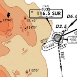
AFCAD file for FS2004 default scenery of Sucre SLSU Juanna A. De Padilla airport in Bolivia.
Brings runway to proper dimensions and adds approach (PAPI) lighting as in the real airport.
High elevation airport (9430 ft.) with surrounding terrain of the Bolivian Andes.
There is no night lighting at this airport. Approach charts included. Recommended mesh terrain: mesh_fermandois003_265585.zip
| Filename: | Sucre_SLSU_Bolivia.zip |
| License: | Freeware, limited distribution |
| Added: | 19th March 2010, 08:55:01 |
| Downloads: | 561 |
| Author: | Kyprianos Biris |
| Size: | 683.9 KB |
| Category: Flight Simulator X - Scenery | |
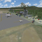
| KCXE - Chase City Municipal Airport - Virginia - USA |
|
Images related to this file:
File Description:
This public airport is located two miles west of Chase City, Virginia.
Created with Airport Design Editor by ScruffyDuck Software using current FAA documentation and Google Earth measurements, this package offers a replacement for FSX's stock airport. All these enhancements are as close to the real airport as I can get with stock library objects and custom models.
| Filename: | KCXE__Chase_City_Municipal_Airport__Virginia__USA.zip |
| License: | Freeware |
| Added: | 13th August 2014, 20:51:37 |
| Downloads: | 299 |
| Author: | Wayne Roberts |
| Size: | 301.88 KB |
| Category: Flight Simulator X - Scenery | |
| Ilorin Airport for FSX\P3D |
|
File Description:
Ilorin International Airport (IATA: ILR, ICAO: DNIL) is an airport serving Ilorin, a city in Kwara State of Nigeria.
The Ilorin non-directional beacon (Ident: IL) is located on the field. The Ilorin VOR-DME (Ident: ILR) is located 4.9 nautical miles (9.1 km) southwest of the airport
-------------------
Photoreal Background, Corrected Parkings, Added more buildings, Ramp Lights, Airport chart....
| Filename: | Ilorin_Airport_for_FSXP3D.zip |
| License: | Freeware |
| Added: | 29th September 2018, 15:28:31 |
| Downloads: | 579 |
| Author: | Raheem Adeleke |
| Size: | 29.58 MB |
| Category: Flight Simulator X - Scenery | |
| MTCH 2011 |
|
File Description:
Cap-Haitien International Airport (IATA: CAP, ICAO: MTCH) is an airport serving Cap-Haitien, a city in the Nord department in Haiti. It is the second largest airport in Haiti.
This file has the right coordenates, with the apron and characteristics of the airport. The runways were resized the gates placed on correct location and number.
| Filename: | MTCH_2011.zip |
| License: | Freeware |
| Added: | 19th August 2011, 00:30:14 |
| Downloads: | 976 |
| Author: | Anwar Gonzalez |
| Size: | 3.32 KB |
| Category: Flight Simulator X - Flight Plans | |
| iFly 737NG Flight Plan for Louis Armstrong International Airport - McGhee Tyson Airport |
|
File Description:
This file contains information for the route for a flight between New Orleans, Louisiana and
Alcoa Tennessee and 12 miles south of Knoxville,Tennesseefor the iFly 737NG using the following
airports:Louis Armstrong International Airport and McGhee Tyson Airport
Departure:Louis Armstrong International Airport
IATA:MSY
ICAO:KMSY
FAA LID:MSY
WMO:72231
Destination:McGhee Tyson Airport
IATA:TYS
ICAO:KTYS
FAA LID:TYS
WMO:72326
| Filename: | iFly_737NG_Flight_Plan_for_Louis_Armstrong_Interna.zip |
| License: | Freeware |
| Added: | 25th March 2025, 18:12:25 |
| Downloads: | 4 |
| Author: | David M. Long |
| Size: | 2.15 KB |
| Category: Flight Simulator 2004 - Scenery | |
| FS2004 Kilimanjaro International Airport V1.1 |
|
Images related to this file:
File Description:
Kilimanjaro International Airport (HTKJ) v1.1. Update to previous V1 scenery, fixed issues with textures. Kilimanjaro International Airport (KIA) (IATA: JRO, ICAO: HTKJ) is an international airport in northern Tanzania that serves the cities of Arusha and Moshi. Scenery was built using Sketchup, Sbuilder and ADE and it consists of a photoreal airport background. By Emmanuel Mwandosya.
| Filename: | FS2004_Kilimanjaro_International_Airport_V11.zip |
| License: | Freeware |
| Added: | 22nd March 2018, 23:56:01 |
| Downloads: | 661 |
| Author: | Emmanuel Mwandosya |
| Size: | 15.64 MB |
© 2001-2026 AVSIM Online
All Rights Reserved
Privacy Policy |