
Where Flight Simulation Enthusiasts Gather from Around the World!
AVSIM Library - Search Results

| Category: Flight Simulator 2002 - Scenery Design | |
| Macros 7 Trucks Light Duty |

|
File Description:
FS2002 Scenery Macros 7-trucks light duty
Complete installation of 7 light duty flatbed trucks in different
configurations and loads including trash pick-up, and liquid
haulers including liquid waste, water, and petrol. Night lighted, Resource photos & Screen shots included.
Scale .02. Airport for Windows 2.60. Original photos and design
by jimmy R martin.
| Filename: | Macros_7_Trucks_Light_Duty.zip |
| License: | Freeware |
| Added: | 19th February 2003, 00:22:11 |
| Downloads: | 884 |
| Author: | Jimmy Martin |
| Size: | 684.79 KB |
| Category: Orbiter - Miscellaneous Files | |
| Gusev Crater Scenery |
|
File Description:
Gusev Crater is an impact crater on Mars that looks as though a lake may have once filled it in the distant past.
Gusev Crater is about 145 km (90 miles) wide. It is located at 14.6° South latitude and 175.3° East longitude, along the boundary between Mars' southern highlands and its lowland northern plains. The crater is about 3,000 km (1,900 miles) southeast of the volcano Elysium Mons. Scientists believe the Gusev Crater was formed by the impact of an asteroid three to four billion years ago.
A valley named Ma'adim Vallis, which is connected to the south side of the crater, looks like it may have been a river channel that poured water into the crater in the past, forming a large lake. If the crater was indeed a lake, scientists expect it to contain layers of sediments as much as 915 meters (3,000 feet) thick that flowed in with the water. There may be other clues to a watery past within the crater, such as deposits of minerals, such as halite and gypsum, that form when water evaporates. Wet environments are the best places to look for life, which is why scientists are so eager to track down places on Mars that were once wet.
On the 3rd of January 2004, MER-A Spirit, one of the two Mars Exploration Rovers (MER) had landed within an 81 km by 12 km (50 by 7 miles) oval near the center of Gusev Crater. Once settled into its new "home", Spirit will begin its mission of exploring for geologic evidence of the presence of water in Gusev Crater's past.
| Filename: | Gusev_Crater_Scenery.zip |
| License: | Freeware |
| Added: | 5th January 2004, 17:56:22 |
| Downloads: | 1,376 |
| Author: | Robert Stettner (Foxtrot) |
| Size: | 378.72 KB |
| Category: Flight Simulator 2004 - Scenery | |
| BFU Manitoba, Canada |
|
File Description:
Scenery for the new FBO of Bush Flying Unlimited, based out of Cross Lake, (CYCR), Manitoba, Canada. Features custom objects, textures, nightlighting, and various starting points, including water, helipad, and runway starts. Included are 2 BFU related destinations, Stan’s Cabin and a BFU sponsored hunting party camp, both include NDBs incase you feel like cheating!
| Filename: | BFU_Manitoba_Canada.zip |
| License: | Freeware |
| Added: | 7th October 2003, 01:32:37 |
| Downloads: | 5,718 |
| Author: | Michael Carr - MCDesigns 2003 |
| Size: | 6.66 MB |
| Category: Flight Simulator 2004 - Scenery | |
| Lake Edward elevation modification |
|
Images related to this file:
File Description:
Modified HP and HL files to raise the level of Lake Edward to fit with terrain with 76m mesh.
The water area around Entebbe airport has also been modified.
Victoria-Nile River has been moved south of Chobe Safari Lodge Strip which was in the river before.
Some modified files for airstrips in Uganda.
| Filename: | Lake_Edward_elevation_modification.zip |
| License: | Freeware |
| Added: | 25th October 2022, 14:30:54 |
| Downloads: | 94 |
| Author: | John Tennent |
| Size: | 759.5 KB |
| Category: Flight Simulator X - Aircraft Repaints, Textures and Modifications | |
| Sikorsky/Erickson S64 Skycrane "Elvis" |
|
Images related to this file:
File Description:
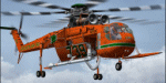
If you're Australian you know bushfires and if you know bushfires you know "Elvis". Elvis is on Lease from Erickson during the bushfire season in Australia, just recently Elvis assisted in the QLD flood effort. This paint is for the heroes that fight bushfires from the air. Textures for the ND S64 Skycrane water bomber
| Filename: | SikorskyErickson_S64_Skycrane__Elvis.zip |
| License: | Freeware |
| Added: | 5th December 2011, 08:43:42 |
| Downloads: | 237 |
| Author: | Matt Levi |
| Size: | 3.52 MB |
| Category: Flight Simulator X - AFCAD Files | |
| KRSW - Southwest Florida Intl. Airport - Fort Myers, Florida - USA v2.0 |
|
Images related to this file:
File Description:
This is an update to my 1.1 release dated 2012-02-03. This release features asphalt shoulders to the runway and taxiways A and F, new taxiways H, J, K and L, relocated fire station, new terminal parking garage and lots, revamped cargo and general aviation parking, and enhanced scenery including water (drainage) polys.
| Filename: | KRSW__Southwest_Florida_Intl_Airport__Fort_Myers_F.zip |
| License: | Freeware |
| Added: | 15th November 2014, 00:50:09 |
| Downloads: | 2,102 |
| Author: | Allen Laughmiller |
| Size: | 38.21 KB |
| Category: Flight Simulator 2004 - Scenery | |
| Paugan & Mercier Dams on the Gatineau River in Quebec Canada |
|
Images related to this file:
File Description:
This will not work without Ultimate Terrain, as the rivers and lakes just won't be there. The Paugan and Mercier Dams are on the Gatineau River in Quebec, north of Ottawa. Both of them are for power generation, rather than water conservation; the Paugan power generation building sits at the bottom of the sluiceway below the dam and appears far larger than the dam itself; there is a separate overflow sluice system nearby. The Paugan Dam is around 30 miles north up the river from Ottawa and the Mercier a further 70 miles. The Mercier holds back a huge and irregularly shaped volume of water known as the Reservoir Baskatong, with numerous branching arms and islands, and you will recognise where the dam must be long before you see it.
| Filename: | Paugan__Mercier_Dams_on_the_Gatineau_River_in_Queb.zip |
| License: | Freeware, limited distribution |
| Added: | 3rd May 2010, 00:11:21 |
| Downloads: | 273 |
| Author: | Roger Wensley |
| Size: | 421.81 KB |
| Category: Flight Simulator 2004 - Scenery | |
| Fountain Head Lodge OK (OF7) |
|
File Description:
FS2004 scenery Fountain Head Lodge OK (OF7)
(park only) with boats in surrounding water.
This scenery will be
compatable with FSX. I suggest you place any Oklahoma files
into the folder I give you here. Also contains update for H76 PAWHUSKA.
Requires EZ scenery library (Lago for pole lights only).
jimmy R martin
[email protected]
jrm_OF7
| Filename: | Fountain_Head_Lodge_OK_OF7.zip |
| License: | Freeware |
| Added: | 13th May 2006, 22:25:25 |
| Downloads: | 404 |
| Author: | jimmy R martin |
| Size: | 637.69 KB |
| Category: Flight Simulator X - Scenery | |
| Vilanculos X |
|
Images related to this file:
File Description:
Baaruto (Vilanculos) is a small but busy airport in Mozambique. It is a very popular holiday destination. Vilanculos is the Mozambican capital of water sports. It's a popular beach resort area. The gateway to the Bazaruto archipelago, Mozambique's only underwater national park. FSX Acceleration will give the best results.(Also SP2 compatable). Acceleration users will have more eye candy!
| Filename: | Vilanculos_X.zip |
| License: | Freeware |
| Added: | 12th March 2012, 14:29:45 |
| Downloads: | 796 |
| Author: | Jacques Botha |
| Size: | 276.42 KB |
| Category: Flight Simulator 2004 - Scenery | |
| Mackenzie River close to Tulita CZFN in Northwest Territories Canada |
|
Images related to this file:
File Description:
I discovered, while testing another airfield near the Mackenzie River, that along the side of the Mackenzie adjacent to Tulita, and for a considerable distance, there was a cliff of water. I have no idea if my version of Ultimate Terrain has developed a fault or if this has been caused by the installation of a terrain mesh that now argues with UT for some unknown reason. Whatever, it was impossible to leave it as it was. I have included a screenshot of the cliff further upstream. To avoid the cliff of water I have flattened that area of the Mackenzie River and the adjacent river banks and both the town and the airfield to a height above sea level of 400 feet. This does not reflect the real life situation but is the lesser of two optical evils. I have included a screenshot of the flattened area. If you do not have a problem then you do not need this. If you too have a cliff of water then you might want to try this. It does not completely get rid of the problem, but it does get rid of it in the area visible when landing or taking off at Tulita.
| Filename: | Mackenzie_River_close_to_Tulita_CZFN_in_Northwest_.zip |
| License: | Freeware, limited distribution |
| Added: | 1st August 2021, 22:27:01 |
| Downloads: | 75 |
| Author: | Roger Wensley |
| Size: | 573.48 KB |


© 2001-2026 AVSIM Online
All Rights Reserved
Privacy Policy |