
Where Flight Simulation Enthusiasts Gather from Around the World!
AVSIM Library - Search Results

| Category: Flight Simulator 2004 - Scenery | |
| Hammonton Municipal, New Jersey (N81) |

|
File Description:
FS2004 Scenery-Hammonton Municipal Airport (N81) serves Hammonton and Atlantic County and is owned by the Town of Hammonton. The paved runway extends for 3,004 feet. The facility is at an elevation of 69 feet at a distance of about 3 miles from Hammonton. Dynamic scenery created with Lago's FSE. FSDS3 textures included. Modified AFCAD2 file. AI traffic. Need EZ Scenery and Rwy12 libraries.
| Filename: | Hammonton_Municipal_New_Jersey_N81.zip |
| License: | Freeware |
| Added: | 4th March 2006, 00:33:51 |
| Downloads: | 1,278 |
| Author: | John B. Loney, Jr. |
| Size: | 637.35 KB |
| Category: Flight Simulator X - AFCAD Files | |
| KIAB - McConnell AFB - Wichita, KS |
|
File Description:
By request, here is an improved version of the stock McConnell AFB including the Boeing manufacturing facility and the Kansas Aviation Museum. I added many Military_Cargo parking spaces. I added the fire station and fire trucks. I removed and replaced some default buildings and added additional buildings. Added static fuel trucks, parking lots with cars and light poles. Added,
removed, or adjusted taxiways and aprons.
| Filename: | KIAB__McConnell_AFB__Wichita_KS.zip |
| License: | Freeware |
| Added: | 31st May 2008, 20:44:30 |
| Downloads: | 1,104 |
| Author: | Jim Cook |
| Size: | 19.21 KB |
| Category: Flight Simulator 2004 - Scenery | |
| Montauk Airport KMTP |
|
File Description:
FS2004 Scenery-Montauk Airport (KMTP) serves Montauk and Suffolk County and is owned by Montauk Airport Inc. The paved runway extends for 3480 feet. The facility is at an elevation of 20 feet at a distance of about 3 miles from Montauk. Dynamic scenery with Lago's FSE. Modified AFCAD2 file and Traffic Tools required. Created with EZ Scenery. EZ Scenery libraries required. By John B. Loney, Jr.
| Filename: | Montauk_Airport_KMTP.zip |
| License: | Freeware, limited distribution |
| Added: | 11th May 2010, 21:42:38 |
| Downloads: | 876 |
| Author: | John B. Loney, Jr. |
| Size: | 392.4 KB |
| Category: Flight Simulator 2004 - Scenery | |
| Vandenberg Airport (KVDF) |
|
Images related to this file:
File Description:
FS2004 Scenery - Vandenberg Airport (KVDF) serves Tampa and Hillsborough County and is owned by Hillsborough Co Avia Auth. The paved runway extends for 3260 feet. The facility is at an elevation of 20 feet at a distance of about 6 miles from Tampa. Requires Nova, NovaGold and NovaSim Textures. Created with FSDS2, Rwy12 and Lago's FSE. AFCAD2 and Traffic Tools a must. By John B. Loney, Jr.
| Filename: | Vandenberg_Airport_KVDF.zip |
| License: | Freeware, limited distribution |
| Added: | 17th May 2010, 22:23:20 |
| Downloads: | 1,357 |
| Author: | John B. Loney, Jr. |
| Size: | 1.15 MB |
| Category: Flight Simulator 2004 - Scenery | |
| Indianapolis Executive KTYQ |
|
Images related to this file:
File Description:
FS2004 Scenery - Indianapolis Executive Airport (Formally known as Indianapolis Terry Airport) KTYQ, serves Indianapolis and Boone County and is owned by R. Vansickle. The paved runway extends for 5500 feet. The facility is at an elevation of 922 feet at a distance of about 14 miles from Indianapolis. Created with FSDS2, Rwy12 and Lago's FSE. AFCAD2 and Traffic Tools required. By John B. Loney, Jr.
| Filename: | Indianapolis_Executive_KTYQ.zip |
| License: | Freeware, limited distribution |
| Added: | 17th May 2010, 22:30:47 |
| Downloads: | 788 |
| Author: | John B. Loney, Jr. |
| Size: | 984.06 KB |
| Category: Flight Simulator 2004 - Scenery | |
| Richmond Municipal Airport KRID |
|
Images related to this file:
File Description:
FS2004 Scenery - Richmond Municipal Airport (KRID), Richmond, IN serves Richmond and Wayne County and is owned by Richmond Boac. The airport has more than one runway. The longest is a paved runway extending 5200 feet. The facility is at an elevation of 1140 feet at a distance of about 5 miles from Richmond. Created for your flying pleasure with Instant Scenery 2 by John B. Loney, Jr.
| Filename: | Richmond_Municipal_Airport_KRID.zip |
| License: | Freeware, limited distribution |
| Added: | 3rd August 2010, 22:22:45 |
| Downloads: | 396 |
| Author: | John B. Loney, Jr. |
| Size: | 5.09 MB |
| Category: Flight Simulator X - Scenery | |
| Richmond Municipal Airport KRID |
|
Images related to this file:
File Description:
FSX Scenery - Richmond Municipal Airport (KRID), Richmond, IN serves Richmond and Wayne County and is owned by Richmond Boac. The airport has more than one runway. The longest is a paved runway extending 5200 feet. The facility is at an elevation of 1140 feet at a distance of about 5 miles from Richmond. Created for your flying pleasure with Instant Scenery 2 by John B. Loney, Jr.
| Filename: | Richmond_Municipal_Airport_KRID.zip |
| License: | Freeware, limited distribution |
| Added: | 3rd August 2010, 22:22:55 |
| Downloads: | 675 |
| Author: | John B. Loney, Jr. |
| Size: | 5.1 MB |
| Category: Flight Simulator 2004 - Scenery | |
| KEKM - Elkhart Municipal Airport - Elkhart, Indiana |
|
Images related to this file:
File Description:
FS2004 Scenery - Elkhart Municipal Airport serves Elkhart and Elkhart County and is owned by the City Of Elkhart, Indiana. The airport has more than one runway. The longest is a paved runway extending 6500 feet. The facility is at an elevation of 778 feet at a distance of about 3 miles from Elkhart. For the enjoyment of the FS community, by John B. Loney, Jr.
| Filename: | KEKM__Elkhart_Municipal_Airport__Elkhart_Indiana.zip |
| License: | Freeware, limited distribution |
| Added: | 22nd March 2013, 19:02:41 |
| Downloads: | 387 |
| Author: | John B. Loney, Jr. |
| Size: | 77.88 MB |
| Category: Flight Simulator X - AFCAD Files | |
| KNOG - Naval Auxiliary Landing Field Orange Grove - Orange Grove, Texas - USA |
|
Images related to this file:
File Description:
NALF Orange Grove is an important support airfield for NAS Kingsville which provides primary jet training (and carrier qualification) for new Navy, Marine, and selected foreign pilots. This is a complete airport rebuild with new runways, new taxiways, ramps, signage, and tower and administration buildings. It features a fire station, POL facility, access roads, new terrain masks, and parking,(including covered parking) for 15 transient aircraft.
| Filename: | KNOG__Naval_Auxiliary_Landing_Field_Orange_Grove__Orange_Grove_Texas__USA.zip |
| License: | Freeware |
| Added: | 4th July 2015, 02:31:38 |
| Downloads: | 340 |
| Author: | Allen Laughmiller |
| Size: | 14.13 KB |
| Category: Microsoft Flight Simulator (2020) - Aircraft Repaints, Textures and Modifications | |
| Goodyear FG-1D Corsair RNZAF NZ5531 |
|
Images related to this file:
File Description:
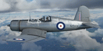
This folder contains a repaint for the FG-1D Corsair by Milviz, in the colors of F4U-1D NZ5531. It was used as a trainer at the RNZAF pilot training facility in Wigram. For some reason it was stripped of its paint and as such, was one of two bare-metal Corsairs with the RNZAF, the other being NZ5526. Repaint by Jan Kees Blom.
| Filename: | Goodyear_FG1D_Corsair_RNZAF_NZ5531.zip |
| License: | Freeware |
| Added: | 24th April 2021, 19:10:12 |
| Downloads: | 25 |
| Author: | Jan Kees Blom |
| Size: | 52.12 MB |


© 2001-2026 AVSIM Online
All Rights Reserved
Privacy Policy |