
Where Flight Simulation Enthusiasts Gather from Around the World!
AVSIM Library - Search Results

| Category: Flight Simulator 2004 - Utilities | |
| Get Tower View V1.1 |

|
File Description:
After landing it would be fine to have an external view (like the tower view) available for the instant replay function.
Unfortunately Microsoft FS leaves the tower where it is after starting the flight and it is a nasty job to locate the tower somewhere in the map view and move it to the desired position.
GetTowerView is a simple tool to adjust the tower view relative to the current aircraft position after landing.
It uses the freeware tool FDSConnection by Flight Deck Software (www.flightdecksoftware.com) (included) and the Delphi-SDK for FDSConnection by Alan Chan ([email protected]).
FDSConnection.PDF is also inluded.
The program was tested with FS2004 but may also work with FS2002.
New features of version 1.1:
- Added storage of custom tower view positions after landing in a drop-down list.
- Fixed bug: Current settings were not stored in version 1.0, when shut down via FSUIPC.
| Filename: | Get_Tower_View_V11.zip |
| License: | Freeware, limited distribution |
| Added: | 6th February 2005, 19:42:09 |
| Downloads: | 3,556 |
| Author: | Wolfgang Meininghaus |
| Size: | 330.49 KB |
| Category: Flight Simulator 2004 - AI Flight Plans | |
| Retro Spangdahlem AB USAF 52nd Tactical Fighter Wing |
|
Images related to this file:
File Description:

Retro AI flightplans and individual repaints for 78 aircraft of the Unites States Air Force 23 TFS, 81 TFS and 480 TFS of 52 TFW based at Spangdahlem [ETAD], Germany [version 2.0]. Two basic options included... Spangdahlem 1985: all three squadrons are equiped with F-4E and F-4G Phantoms all painted in "Euro1". Spangdahlem 1988: all three squadrons are equiped with F-16C/D Falcons and F-4G Phantoms of which most Phantoms are painted in "Euro1" and some of them in the grey "Hill" colour scheme. All the flightplans were individually tailored for the aircraft manually. This is to give a more realistic set of flightplans and is a massive update of Version 1.0 with retro destinations and additional flightplans added together with revised departure/arrival times. Callsigns by Stewart Pearson included. See also included readme file for more details on this package...
| Filename: | Retro_Spangdahlem_AB_USAF_52nd_Tactical_Fighter_Wi.zip |
| License: | Freeware, limited distribution |
| Added: | 15th April 2013, 20:13:02 |
| Downloads: | 1,215 |
| Author: | Chris A Brown and Eric Kunst |
| Size: | 70.68 MB |
| Category: Flight Simulator X - Utilities | |
| FSXAIS - Update 1.1.62 |
|
Images related to this file:
File Description:

FSX AI Spotter is a program that is able to schedule AI Aircraft flights (departure and arrivals) for a certain airport using both manual and "live" traffic information.
In the manual mode, the user is able to populate the airport using a simple formatted text file while in the live mode, using geniXsoft "connector", is possible to connect to flightaware.com to get real-time information. FSXAIS then will automatically visualize aircrafts and assigns them flightplan accordings to the scheduled received from the Web.
This update is able to assigns - for the same aircraft type and airline - different aircraft variation if they are available from FSX (i.e. if more than one kind of B738 of Ryanair are available in FSX, each of them will be used for the schedule). A video for such situation is available at http://youtu.be/7FhvtbTaL_A
Necessary a 1.0 full setup of FSXAIS
| Filename: | FSXAIS__Update_1162.zip |
| License: | Shareware, limited functionality |
| Added: | 21st November 2011, 17:18:43 |
| Downloads: | 924 |
| Author: | Vincenzo Mercolino |
| Size: | 1.48 MB |
| Category: Flight Simulator X - Scenery | |
| Thomas Hudner AFB |
|
File Description:
Thomas Hudner AFB is a fictitious Air Force Base located at Henderson Island, a member of the Pitcairn Islands in the Pacific. Located in a sheltered bay on the east side of the island, the airport features a 7500' x 120' paved runway, several hangars, barracks, and a fire dept. This airport also features a Delta V rocket and launch pad, a container ship being unloaded offshore by hovercrafts, and a small military ship. The default FSX scenery at this island has been completely replaced with custom scenery and terrain based on satellite photos.
This scenery requires the FSX Acceleration expansion pack for all of the objects to show up properly. Also, for some reason, Ground Environment X causes the sand textures to show up as rain forest. This is purely a visual quirk and the airport will still work, but it is up to you. This airport is not designed for FS2004, but you may try it at your own risk. Special thanks to Ashton Lawson for his invaluable help on this project.
| Filename: | Thomas_Hudner_AFB.zip |
| License: | Freeware, limited distribution |
| Added: | 31st January 2009, 01:29:20 |
| Downloads: | 541 |
| Author: | Daniel Otto |
| Size: | 1.57 MB |
| Category: Flight Simulator X - Scenery | |
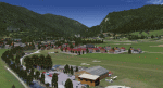
| LOSM Mauterndorf, Austria Version1 for FSX and P3D_v3/v4 |
|
Images related to this file:
File Description: The Airfield Mauterndorf is the highest situated airfield in Austria: 3642 ft or 1110 meters above sealevel.
This Airfield is very common for glider flyers due to the usually good upwinds for flying in the alps. But also small engine aircrafts are approved. Link:
http://www.losm.at/index.php/losm.html The environment of the airfield is adapted by landclasses. Mauterndorf and the surrounding villages, valleys and major roads are included.
As well the field is covered by a photo background, wich includes four different images , each for one of the four seasons spring, summer, autum and winter. The buildings in this scenery are designed mainly new by myself, but also a lot of objects from two very popular freeware libraries.
If these libraries are not installed, many objects are not visible! The following libraries are used: 1. FS-Piloten_Objektlibrary:
http://www.fs-piloten.de/thread.php?threadid=10632 2.FSX_FlightPortLib:
http://www.flightport.de/libraries/flightport-library/ This senery works also with Austria Professional HD.
| Filename: | LOSM_Mauterndorf_Austria_Version1_for_FSX_and_P3D_.zip |
| License: | Freeware |
| Added: | 28th August 2017, 20:01:00 |
| Downloads: | 477 |
| Author: | Wolfgang Allers |
| Size: | 249.9 MB |
| Category: Flight Simulator X - Scenery Design | |
| (Version 2.0) KEFD -Ellington 2025 Refresh FSX (Circa 2006-2010)- Johnson Space Center Houston |
|
Images related to this file:
File Description:
Version 2.0 covers landclass across the entire greater Houston area, with a large increase in LOD. This version significantly tightens up and improves the landclass from version 1.0, and adds a vast amount of scenery objects that brings the Bay Area-KEFD area into the modern era. This improves and adds a highly accurate runway 17 approach with accurate placement of buildings and scenery around the year 2011-modern day. In addition, includes several new files including a new airport/helipad via Houston Clear lake regional airport, T41 La Porte Municipal and surrounding shipping ports, Kemah Boardwalk, and a giant improvement to Johnson Space Center Houston. Rundway 35 and Runway 22 landclass is significantly increased, and more accurate as well. You can fly an accurate VFR approach or set up an ILS for any one of KEFD's runways with ease with this improvement.List of Version 2.0 additions and changes: - I added a ton of scenery objects and tightened up the landclass at Johnson Space Center Houston- NASA Control Center--- Added Talon Park with T38s (via static objects)--- Added Gemeni V rocket and 747 for the shuttle transporter--- And a whole bunch of vegetation, new buildings, and tour buses.- Added Kemah boardwalk and several boat docks- Removed a TON of highrise textures and replaced with medium and large city suburb landclass.- Added Clear Lake regional Hospital with helipad and surrounding scenery by Walter Reed Park- Added El Jardin or "Bayport Container port" with several scenery objects and significantly tightened up landclass.-- Looks great when setting up ILS approach for RWY 22- Tightened up Bay Area BLVD landclass, "adding" University of Houston Clear Lake"-- UHCL was semi already present, just made it more pronounced.- Made Red Bluff road landclass super recognizable!-- Red Bluff road is used to set up VFR approach and or field break for RWY 22 and RWY 17 R.----- Its common to see private jets and the USAF doing a break along Red Bluff road.- Added First Baptist Church, and water tower to Pasadena Convention center- Made Fairmont Parkway pronounced with landclass- Added Houston Port Authority at Morgan's Point--- Another Landmark for the RWY 22 ILS approach, NASA religiously uses this to line up the 10 mile ILS.- Tightened up landclass at Village Grove East and along Fairmont Parkway- Added a TON of scenery objects and landclass corrections for approach of RWY 17 L and 17 R.---- Added Home Depot, Lowes, Walmart Super center, Guitar center etc.---- added South Main Baptist Church--- Bondy Jr High, Turner Elementary, and Pasadena Memorial High School--- Added Saint Luke's Hospital--- Added Hampton Inn Suites and HCA rehab hospital--- Added a ton to the container facility behind best buy and storage facility--- Added smaller churches on RWY 17 approach--- Added a ton of scenery at the base of RWY 17 R, i.e., concrete plant, containers, trucks-- Added gas stations on the corner of beltway 8 and genoa red bluff-- Significantly changed and tightened up landclass at the base of RWY 22 and RWY 17 L and 17 R-- Made several roads and Beltway pronounced------ This decision looks AWESOME at night, really adds demarcation to the roads.**All of this makes the RWY 17 approach super recognizable** RWY 22 approach landclass is much more accurate.- Significantly changed and tightened up landclass near southbelt ellington and interstate 45.- Added Grace Church-- I wanted to do San Jacinto College south, but seemed over kill at that point.- SIGNIFICANTLY tightened up landclass for RWY 35 approach and near baybrook mall.-- Along I45- Added TDECU stadium at the University of Houston Main Campus---- So you can practice flybys for Cougar games!- Added the Battleship at San Jacinto Monument- I also "borrowed" T41 La Porte Municipal's tower camera to make a SWEET view of KEFD.- I included landclass for Sealy Texas this time, as well as my significant enhancements of Austin, Texas greater area as well (optional, but recommended!)---------------------------------------------------------------------------Version 1.0 originally added:- Added the Johnson Space Center Houston, which is now greatly enhanced and blended.- San Jacinto Community College-Central- Pasadena Convention Center- Pasadena Water Treatment Facility- NASA Bouncy Lab- Pasadena Shopping center, now greatly enhanced and blended.- Baybrook Mall and other shopping spots.- Significant Landclass improvements across the entire greater Houston Area File also includes landclass and scenery improvements for the greater Austin, Texas Area (optional), KIAH, KDWH, and Sealy, Texas. Each of these projects combined covers roughly 15,000 square miles of landclass improvement. Allowing you to fly entirely from Houston to Austin, or Houston to San Antonio in accurate landclass. -Enjoy!DJN
| Filename: | Version_20_KEFD_Ellington_2025_Refresh_FSX_Circa_2.zip |
| License: | Freeware |
| Added: | 12th October 2025, 16:15:47 |
| Downloads: | 65 |
| Author: | Dan Nelson |
| Size: | 277.28 MB |
| Category: X-Plane - Scenery | |
| WXPN Susi Air Pulau Nurseen Airstrip v1.0.0 |
|
Images related to this file:
File Description:

This is an X-Plane 11 scenery for Pulau Nurseen Airstrip (WXPN) in the Island of Nurseen, Indonesia. This is a fictitious airfield, located in a tiny isolated island. This fictitious airfield may serve as a stopover for flights between Java and Papua, for the Susi Air scenery package. This is one of the destinations for "PT ASI Pujiastuti Aviation", operating as Susi Air, an Indonesia airlines established in late 2004 by Mrs. Susi Pudjiastuti. This scenery was tested and is operational (as of January 17, 2017) in "X-Plane 11 Public Beta #5 64 bit", Windows 10 Home. It was also tested and is not really operational (as of January 17, 2017) in "X-Plane 10.51 64 bit", Windows 10 Home. XP10's mesh is different, and presents problems in placing the runway over the water, instead of the land, plus some terrain elevations issues as well. Sorry, XP11 only.
| Filename: | WXPN_Susi_Air_Pulau_Nurseen_Airstrip_v100.zip |
| License: | Freeware |
| Added: | 18th January 2017, 05:00:53 |
| Downloads: | 45 |
| Author: | Rui Mesquita |
| Size: | 2.65 MB |
| Category: Flight Simulator X - Flight Plans | |
| S.O.S Belize Atolls |
|
File Description:
The " Nozyru San Maru" a Japanese Zoo Ship. Or rather a ship
which is carrying many animals to the Belize Zoo is in deep trouble. Not in deep
water but on the shallows of an Atoll off the coast of Belize. While everyone was
entertained last night feeding the animals a large wave hit the ship on its side
and crashed it into the atoll. Many animals jumped out into the atoll and are running
around howling their throats out. Some were placed in lifeboats and the current has
taken them away, really quite a mess!!!..besides Hurricane " Bubble" is on its way
to the Central American Coasts and wind is picking up fast!!!! a radioless fishing fleet
must also be warned of the coming danger.....will you join this
unusual (to say the least) SAR Mission????...or will you watch the news of it on CNM?
| Filename: | SOS_Belize_Atolls.zip |
| License: | Freeware, limited distribution |
| Added: | 19th August 2007, 11:34:19 |
| Downloads: | 732 |
| Author: | Gera Godoy C |
| Size: | 282.18 KB |
| Category: Flight Simulator X - Scenery | |
| Quebec CYQB |
|
File Description:
This is the second edition of CYQB Quebec Jean Lesage Int’l airport for FSX. Countless hours over a two years period have been devoted to develop this very accurate and truly remarkable scenery. It includes more than 50 highly detailed buildings, hangars and special features making this scenery extremely realistic and for the virtual pilot a place to visit. The center piece is the new terminal shaped like an airfoil that has been inaugurated last June. Very diversified operations take place at this airport from flying school, aircraft overhaul and international charter to domestic traffic. You will find also a fleet of 14 CL215 and CL415 water bombers operated by the Service Aerien Gouvernemental. Flying to CYQB at the control of your favorite plane will be a truly enjoyable experience. After a first visit to this airport you will make Quebec one of your favorite destinations. It is guarantee.
| Filename: | Quebec_CYQB.zip |
| License: | Freeware |
| Added: | 13th April 2009, 07:58:27 |
| Downloads: | 6,781 |
| Author: | Gilles Boily |
| Size: | 12.03 MB |
| Category: Flight Simulator 2004 - Scenery | |
| Caballococha, Peru |
|
File Description:
Caballococha, Peru - Actually I have found only one photo of the town along the Amazon River and it was only of the Plaza. This is a total impressionistic file. Creates the town, riverside features (Piers, Ferry landing) and a few features to the default airport.
New AFCAD created offering parking and a taxiway, plus two water start locations. Again totally fictious. BUT enjoy.
One thing about Caballococha is that it is along a highly navagatable portion of the Amazon and with the fantastic array of Watercraft available offers, I believe, unlimited simming possibilities.
I included the .XML file for rwy12, if you are into enhancing your own scenery...please do feel free to modify or add as desired. This scenery DOES require both LAGO FSE (Payware) and RWY12 available here at avsim) to work.
questions or comments PLEASE do e-mail me ... I will respond as rapidly as possible.
[email protected]
| Filename: | Caballococha_Peru.zip |
| License: | Freeware |
| Added: | 9th April 2006, 04:19:26 |
| Downloads: | 714 |
| Author: | Dale Caruso |
| Size: | 225.37 KB |
© 2001-2026 AVSIM Online
All Rights Reserved
Privacy Policy |