
Where Flight Simulation Enthusiasts Gather from Around the World!
AVSIM Library - Search Results

| Category: Flight Simulator 2004 - Gauges | |
| FS2004 Simulated Aircraft Bubble Sextant |

|
File Description:
As travel by air developed and matured, navigation over long distances also developed and improved. In the early days, however, air navigation essentially used ship navigation techniques adapted for aircraft. Without "landmarks", the navigators used Ded Reckoning (DR) and the stars. Celestial or Astronomical Navigation provides a means of obtaining Lines of Position (LOPs) from the stars. Crossing LOPs will fix a position. It requires a chart, and a planned course on that chart, with waypoints specified by Latitude and Longitude, an assumed time of arrival at each waypoint, and stars (including the Sun, Moon, or planets) in view. In the 1940s, extensive tables of star positions were made available to air navigators to be used with sextants to obtain these LOPs. In the tables, all times involved are GMT. This data is available from the Internet in "ready to use" form. This gauge simulates the sextant, and the process by which one obtains a LOP, or crossing LOPs to obtain a position, or fix. Can be used with any FS2004 aircraft. Includes comprehensive browser-based manual and references.
| Filename: | FS2004_Simulated_Aircraft_Bubble_Sextant.zip |
| License: | Freeware |
| Added: | 6th December 2004, 19:21:14 |
| Downloads: | 4,977 |
| Author: | Dave Bitzer, Mark Beaumont |
| Size: | 989.73 KB |
| Category: Flight Simulator 2004 - Scenery | |
| DTTG Gabes, Tunisia |
|
File Description:
Googly scenery for Gabes (ICAO: DTTG), a somewhat nondescript airport
shoe-horned into one of Tunisia's largest industrial cities. Famed for
its beaches, the city hosts cement, chemical and brick factories and an
oil refinery, resulting in poor levels of air pollution. The airport is
a joint military and civilian operation although military traffic appears
to be mostly helicopter activity and the civilian traffic consists of an
ATR of Sevenair calling in once in a blue moon.
Microsoft have only provided a runway at this airport in Flight Simulator
2004 and this scenery seeks to redress the situation so that you and your
"AI" traffic can use the airport realistically.
The scenery does not purport to be ultra-accurate. Based on high quality
satellite imagery from Google Earth, the layout is proportionally correct but the
added airport features, such as buildings, are built from default Microsoft objects
and add-on libraries so will not look exactly like the real thing.
You are not obliged to download and install any additional scenery libraries,
but to enjoy this scenery in its entirety, you may wish to. It will work fine,
with or without.
| Filename: | DTTG_Gabes_Tunisia.zip |
| License: | Freeware |
| Added: | 14th October 2008, 13:18:33 |
| Downloads: | 757 |
| Author: | John Hinson |
| Size: | 83.15 KB |
| Category: Flight Simulator X - Flight Plans | |
| A Normal Day Over Nepal...or " Hope the God Buzzard don´t get you" !!!!!! |
|
File Description:
Captain Jackson Kungfu-Larz has been flying the Lukla route for around
21 years. Flying tourists and mountain climbers to this little mountain town is just
one of those things. Today he and his co-pilot, you, will abbandon the regular route
and take a "supply" plane from Lukla to Tumlingtar where you´ll will pick up
spare parts for a Polish Motorcicle group out in a mountain road, then you fly to Gutaba where
you will transfer to a Helicopter to carry these, food and purified
water to some arqueologists out in some old Temples and other stuffs for a group of tourists
out in a very old Buddist Monastery spending the weekend. You will return after delivery of all this
to Gutaba and fly two Engineers to Ku-Kle where the trip ends, either in the tarmac or against the mountain
....So get to speed with the old Twin Otter or similiar aircraft and be prepared to pray several times to
the Lord Budda for this "trip" is a "rock breaker". (Shalam sum quan Pin, lip sum turog) Translation:
When the buzzard squaks so loud is because his feathers feel the moon......PD. Nepalese old saying
which no one knows what it means.
| Filename: | A_Normal_Day_Over_Nepalor__Hope_the_God_Buzzard_do.zip |
| License: | Freeware, limited distribution |
| Added: | 3rd June 2008, 19:59:40 |
| Downloads: | 1,680 |
| Author: | Gera Godoy Canova |
| Size: | 838.12 KB |
| Category: X-Plane - Aircraft Repaints, Textures and Modifications | |
| 118527 "Jiminy Cricket" Douglas C-47D |
|
Images related to this file:
File Description:
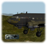
This is a livery-paint for the Leading Edge Simulations Douglas DC3/C47.
Paint made by Leen "Flybike" de Jager
This paint depicts (more or less,within the limitations of the model and its painter) the C47-D ,118527 "Jiminy Cricket "
Historical Note:
"Jiminy Cricket" is depicted as it flew for the Sicily operation in improvised night camouflage.
It was one of the original 52 C-47s that deployed to Egypt with the 316thTCG in December 1942.
"Jiminy Cricket" was one of the first from the 316th Sq.
ATC, to visit Project 19, delivering worn out parts and returning rebuilt
engines to the RAF. It eventually took part in the invasion of Sicily,
where, the pilot, Sgt. George Quisenberry received wounds from German FLAK.
The shell destroyed the nose of the Aircraft, knocking out all instruments
except the stand by compass. Jiminy carried the crew back with nothing but
the moon and the sticking standby compass. Jiminy Cricket was repaired and
served through May 1, 1947, then was "salvaged"
The skin-set includes cockpit- and (freighter-) cabin textures as well.
Passenger-seats, luggage-racks ,airco etc.removed from the plane.( its a freighter now !!)
Livery dedicated panel and cockpit colors
How to install:
Just unzip118527JiminyCricket.zip into a temp. folder , and start reading the readme file.
Have fun and enjoy,
Leen "Flybike" de Jager
http://www.flybike-paints.nl
| Filename: | 118527_Jiminy_Cricket_Douglas_C47D.zip |
| License: | Freeware, limited distribution |
| Added: | 22nd June 2013, 16:59:45 |
| Downloads: | 183 |
| Author: | Leen "Flybike" de Jager |
| Size: | 40.26 MB |
| Category: Orbiter - Orbital Stations | |
| Skylab 2 Mission |
|
File Description:
The Skylab space station was launched May 14, 1973, from the NASA
Kennedy Space Center by a huge Saturn V launch vehicle, the moon
rocket of the Apollo Space Program. Sixty-three seconds after liftoff,
the meteoroid shield--designed also to shade Skylab's workshop
--deployed inadvertently. It was torn from the space station by
atmospheric drag. This event and its effects started a ten-day period
in which Skylab was beset with problems that had to be conquered
before the space station would be safe and habitable for the three
manned periods of its planned eight-month mission.
skylab 2
25 May 1973 13:00 GMT. Duration: 28.03 days. Call Sign: Skylab. Backup
Crew: McCandless, Musgrave, Schweickart. Nation: USA. Agency: NASA.
Launch Site: Cape Canaveral . Launch Complex: LC39B. Launch Vehicle:
Saturn IB . LV Configuration: Saturn IB s/n SA-206. Program: Skylab.
Class: Manned. Type: Lunar spacecraft. Spacecraft: Apollo CSM. Payload
: Apollo CSM 116. Mass: 19,979 kg. Location of Spacecraft: Naval
Aviation Museum, Pensacola, FL. Perigee: 427 km. Apogee: 439 km.
Inclination: 50.0 deg. Period: 93.2 min.
Epic repair mission which brought Skylab into working order. Included
such great moments as Conrad being flung through space by the whiplash
after heaving on the solar wing just as the debris constraining it
gave way; deployment of a lightweight solar shield, developed in
Houston in one week, which brought the temperatures down to tolerable
levels. With this flight US again took manned spaceflight duration
record.
| Filename: | Skylab_2_Mission.zip |
| License: | Freeware |
| Added: | 7th January 2003, 04:31:25 |
| Downloads: | 907 |
| Author: | Ronald Dandurand |
| Size: | 3.76 KB |


© 2001-2026 AVSIM Online
All Rights Reserved
Privacy Policy |