
Where Flight Simulation Enthusiasts Gather from Around the World!
AVSIM Library - Search Results

| Category: Flight Simulator 2002 - Aircraft Repaints, Textures and Modifications | |
| FS2002 Val-U-Prop Plane and Panel |

|
File Description:
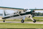
FS2002 Val-U-Prop Douglas DC-3 Plane and Panel
Val-U-Prop is a (fictional) rogue airline based in Bloomington, Indiana, that flies everything from VIPs to sheep manure anyplace and anytime. VP's motto is "No job too small; No fee too large," and our DC-3's and DC-6's can be seen hedge-hopping into various obscure airports throughout the USA. Based on the lovely DC-3 Pluna by Daniel Gazzano, this aircraft is a re-paint of the fabulous DC-3 OH-LCH by Jan Visser, Erik Ellis, Roy Chaffin, Ian Roper and Bill Rambow, to which FS2002 lights have been added. Panel includes everything on main panel, except for GPS, so there is no tabbing. (Default pop-up radio stack is also included.) Panel is based on photographs by Bill Blanchard (lower panel) and Shawn Clark (upper). The very aluminal wing views were shot by Thomas Andre Hjelmen, and the 1930s cabin was photographed by Ben Wang and is populated with various VIPs. All of this brought to you by Val-U-Prop - where WE VAL-U-YOU! By James Underwood
| Filename: | FS2002_ValUProp_Plane_and_Panel.zip |
| License: | Freeware, limited distribution |
| Added: | 26th February 2003, 16:36:44 |
| Downloads: | 600 |
| Author: | James Underwood |
| Size: | 6.2 MB |
| Category: Flight Simulator 2004 - Scenery | |
| PADL - Dillingham - Alaska, USA |
|
Images related to this file:
File Description:
Dillingham is a town with a population of around 2,300 at the southeast corner of the Bering Sea in Bristol Bay, 70 miles west of King Salmon. The town's economical well being is based on the commercial price of salmon and the numerous surrounding sport fishing lodges. FS9 shows the town as way more extensive than it is; the landclass textures correct this. The airport is a mile west of the town and has a single runway 6,400 feet long and orientated 01-19. There are scheduled passenger flights by Alaska Air (numerous in summer and non-existant in winter) and PenAir (year around) plus cargo flights by Everts and Northern Air Transport, and local scheduled flights by Grant Air; the AI includes these, plus GA. The GA gravel apron is behind the main apron and across a road, which is unusual. The parking on the asphalt apron is marked; in actuality there are no markings but landing at a field in FS9 that doesn't have a control tower leaves one wondering where to go; the six spots at the far northern end are unused by AI and free for visitors.
| Filename: | PADL__Dillingham__Alaska_USA.zip |
| License: | Freeware, limited distribution |
| Added: | 14th May 2015, 17:35:29 |
| Downloads: | 393 |
| Author: | Roger Wensley |
| Size: | 10.39 MB |
| Category: Flight Simulator 2004 - Original Aircraft | |
| DHC-2 Beaver |
|
Images related to this file:
File Description:
Re-upload following Avsim hack. The piston powered Beaver is one of the world's better known aircraft. A true workhorse in every sense.
Main cabin can seat eight passengers. Approximately 1700 DHC-2 aircraft were built over a 20 year period with the first flying in 1948. A later model in 1963 increased capacity and had turboprop engines.
This model incorporates animated rudder, elevator, flaps and ailerons.The main model contains only 1131 polygons with a single texture file to ensure the absolute minimum impact on your framerates.
There are three other models incorporated to give a total of 4 LOD models.
It is designed specifically to enhance the aircraft population to use with the marvellous GA-Traffic programme by Marcus Brunner
There are three textures included plus a paintkit in this zip file.
A special thanks to Steven Grant for his kind permission to enable me to use his excellent FDE for this aircraft. This enables the aircraft to also be flown if you so wish. You will of course need to add a suitable panel to the folder.
Designed with FSDS v2.24
Aircraft and textures by Mike Cronin
| Filename: | DHC2_Beaver.zip |
| License: | Freeware, limited distribution |
| Added: | 31st August 2010, 23:44:54 |
| Downloads: | 4,473 |
| Author: | Mike Cronin |
| Size: | 240.06 KB |
| Category: Flight Simulator 2004 - Scenery | |
| Chignik Lake A79 and Port Heiden PAPH - Alaska, USA |
|
Images related to this file:
File Description:
These are two villages in Alaska, in the peninsula that is the start of the Aleutians. Both are east of Perryville, Chignik Lake by 30 miles on the south side of the peninsula and Port Heiden by 75 miles on the north coast. Both are served by Grant Aviation government-subsidised regional flights from King Salmon. Chignik Lake has a population of around 70. There are two buildings on the airfield, but passengers still wait in their car for the plane to arrive as there is no terminal building as such. The runway is 3,300 feet of gravel aligned 08-26, as are so many in this area. Port Heiden is on the north shore of the peninsula, and the population is around 100. FS9 showed the town as being large enough to house 10,000; the new landclass here reduces this to the actual 40 or so houses, one and a half miles south of the airport. The roads are still the FS9 originals, which are approximately in the right place but are brightly lit at night as I was too lazy. The main occupation is fishing. There are buildings on the airfield (mostly old, except for a garage building) but passengers again wait in their cars for the plane to arrive. The two runways are both gravel, and are 05-23 of 6,200 feet, and 13-31 of 4,400 feet.
| Filename: | Chignik_Lake_A79_and_Port_Heiden_PAPH__Alaska_USA.zip |
| License: | Freeware, limited distribution |
| Added: | 30th March 2015, 20:28:47 |
| Downloads: | 291 |
| Author: | Roger Wensley |
| Size: | 5.1 MB |
| Category: Flight Simulator 2004 - Scenery | |
| Nikolski (IKO), Nelson Lagoon (Z73), & Perryville (AK5) - Alaska, USA |
|
Images related to this file:
File Description:
These are villages in Alaska, spread out east and west of Dutch Harbor in the Aleutians and the peninsula, served by Grant Aviation regional flights from Dutch Harbor, Cold Bay, or King Salmon.
Nikolski is 115 miles west of Dutch Harbor at the western end of Umnak Island, which is just west of Unalaska, the large island adjacent to Dutch Harbor. Nikolski is small, with a population of perhaps only 20 now, and the main claim to fame is the wrecked Reeve Aleutian DC3 at the end of the runway. The runway is 3,500 feet of gravel aligned 08-26. Nelson Lagoon is on the north shore of the peninsula, 55 miles north of Sand Point and on a long spit of land that curves around to make the lagoon. There is no access except by boat or plane for the population of around 50. The airfield is a mile east of the village with a gravel runway 08-26, 4,000 feet long. Perryville is on the south shore of the peninsula, 65 miles east of Sand Point. The population is around 115, and the airfield is southwest of the town with the 3,500 feet of gravel runway aligned 02-20 beside the shore. There is a hangar on the apron, but no terminal building.
| Filename: | Nikolski_IKO_Nelson_Lagoon_Z73__Perryville_AK5__Al.zip |
| License: | Freeware, limited distribution |
| Added: | 14th March 2015, 13:27:53 |
| Downloads: | 255 |
| Author: | Roger Wensley |
| Size: | 11.45 MB |
| Category: Flight Simulator 2004 - Scenery | |
| Bethel PABE in southwest Alaska |
|
Images related to this file:
File Description:
There are four main northwestern Alaska towns which have good airports and are serviced by Alaska Airlines. From these airports local flights connect to nearby villages, "nearby" in Alaska meaning up to 200 miles away. The northernmost is Barrow. Southwest of Barrow is Kotzebue, then Nome, and the furthest south is this one, Bethel. The town of Bethel has a population of just over 6,000 and is 50 miles from the sea on the Kuskowim River, that splits and forks into many tributaries. Bethel Airport is close to the town and provides the only contact with the rest of Alaska, as there is no connecting highway system. There are scheduled flights by Alaska Airlines, ERA (now called Ravn) and Grant Aviation, plus others such as Ryan Air. There are cargo flights by Everts, Northern, and Lynden, and redistribution onwards to nearby villages by the smaller locally-based planes; all of these are included in the AI. There are two main runways, one just under 6,400 feet and another just under 3,900 feet, both of them aligned 19-1. The third runway is around 1,800 feet and mainly gravel, aligned 11-29. Parking at PABE is on three aprons, the northern for smaller commercial planes of Grant, ERA, Ryan etc, the central for larger planes of Alaska, Northern, Everts, and Lynden, and the southern for a large collection of GA; each apron has further hangars for maintenance companies and smaller operators. There is also another separate apron for the local military and Coastguard. There is not much photographic information available for PABE, and I have never been there; as a result it was impossible to make detailed photographic textures for some of the buildings. However, for most hangars I have made textures of at least the right colour etc based on the information I assembled and if it is green with white trim and side windows then that is how it now appears here. The exceptions are the Alaska Airlines terminal building which has complicated curved elements, and the two military hangars and workshops where I had to settle for an Alaska terminal building from another airport and the same for the military. There are numerous small villages in the vicinity of Bethel, all of them being beside either a river tributary or the coast. There are two Google Earth screenshots to show the villages that are served by the flights from Bethel and that are (mostly) included in the AI. Some of these airfields were not included in FS9 but AI will still operate in and out of Bethel. The smaller area screenshot shows the villages that are close to Bethel, and of these eight I have so far made six and they are included in this post: Napaskiak PKA, Napakiak WNA, Kwethluk KWT, Atmautluak 4A2, Nunapitchuk 16A, and Kasigluk Z09. I will work my way through the rest of the area.
| Filename: | Bethel_PABE_in_southwest_Alaska.zip |
| License: | Freeware, limited distribution |
| Added: | 8th March 2019, 00:37:58 |
| Downloads: | 303 |
| Author: | Roger Wensley |
| Size: | 32.02 MB |
| Category: Flight Simulator 2002 - Aircraft Repaints, Textures and Modifications | |
| DHC-2 Beaver Amphibian N9279Z |
|
File Description:
repaint of Steven Grant's DHC-2 Beaver Amphibian based on a real aircraft paint scheme. Textures only, requires bvrpak.zip for complete aircraft.
| Filename: | DHC2_Beaver_Amphibian_N9279Z.zip |
| License: | Freeware, limited distribution |
| Added: | 11th April 2003, 23:49:02 |
| Downloads: | 451 |
| Author: | Original Aircraft by Steven Grant, Repaint by Ross Aldrich |
| Size: | 901.49 KB |
| Category: Flight Simulator 2002 - Original Aircraft | |
| DeHavilland DHC-2 Beaver Straight Floats |
|
File Description:
Dehavilland DHC-2 Beaver Straight Floats. Redone using FSDSv2 this version features 32bit reflective textures, dynamic shine and 3 paint schemes.
| Filename: | DeHavilland_DHC2_Beaver_Straight_Floats.zip |
| License: | Freeware, limited distribution |
| Added: | 14th March 2003, 02:57:06 |
| Downloads: | 4,021 |
| Author: | Steven Grant, Fred Choate, Aaron Swindle, and Horst Weingärtner |
| Size: | 4.18 MB |
| Category: Flight Simulator 2004 - Scenery | |
| Naknek (5NK) and Naknek South (WSN) - Alaska, USA |
|
Images related to this file:
File Description:
Naknek and Naknek South are two towns close to the mouth of the Naknek River and on opposite banks. King Salmon is approximately 15 miles to the east. The canneries on both banks of the river are the reason for the existence of both towns and airfields, with fishing for salmon being the primary industry of the area. This takes place from the beach by individuals, by small boats in the river and the immediate sea area, and offshore by larger craft. There is a picture of one boat unloading in Naknek which will be known to anyone who has watched the most famous television fishing programme of all, Deadliest Catch. Cornelia Marie is better known for the crab fishing based in Dutch Harbor, but this area too is just as productive though without the drama. Naknek 5NK has two gravel runways and a float runway in the adjoining lake; all three are just under 2,000 feet long. Naknek South WSN has two gravel runways, 12-30 being 3,300 feet long and 04-22 2,260 feet. As the road connecting to King Salmon is on the north bank it is probable that more seasonal workers are brought into the southern canneries by air, hence the longer runway (and with PAPI on 12). Grant Aviation run scheduled flights into both and there are numerous seasonal charter flights. The AI is a further modification of that posted with King Salmon PAKN and includes these flights, and presumes that you have already downloaded PAKN.
| Filename: | Naknek_5NK_and_Naknek_South_WSN__Alaska_USA.zip |
| License: | Freeware, limited distribution |
| Added: | 29th April 2015, 20:44:31 |
| Downloads: | 214 |
| Author: | Roger Wensley |
| Size: | 6.09 MB |
| Category: Flight Simulator 2004 - Scenery | |
| 9A8 - Ugashik, PAII - Egegik, AK96 - Bartletts, AK36 - Coffee Point , Alaska, USA |
|
Images related to this file:
File Description:
All four of these depend heavily on fishing but two of them only spring into existance during the salmon catching-and-canning season. Grant Air run scheduled flights to the two permanent settlements, and there are irregular scheduled flights and charters to the others according to demand. Ugashik is a permanent settlement 60 miles northeast of Port Heiden, stretched out along the east bank of the Ugashik River. There are two canneries, one old and collapsing and the other newer and functioning. The population is given as 12, though during the season this increases significantly. The (newer) airfield is at the northern end of the village with a gravel runway 3,500 feet long aligned 06-24. Egegik is the second permanent settlement, 45 miles north of Ugashik and 40 miles southwest of King Salmon, on the east bank of the Egegik River. The town is on a corner of land, with a population of around 110 and two operating canneries. The airport is a mile and a half south of the town with two gravel runways, 12-30 at just under 5,600 feet and 03-21 with 1,500 feet; both are lit. On the other side of the Egegik River are more canneries and two airfields, both of which have two runways but are otherwise entirely without facilities or luxuries such as lights. They are called Bartletts (named for the cannery it serves) and Coffee Point (named for the location). The shacks of the seasonal fishermen are strung out along the coast and a lot of the salmon fishing is by net, laid by a small boat and later pulled ashore for emptying. Only one cannery on the west shore has a docking facility for unloading boat-caught fish.
| Filename: | 9A8__Ugashik_PAII__Egegik_AK96__Bartletts_AK36__Co.zip |
| License: | Freeware, limited distribution |
| Added: | 3rd April 2015, 18:06:49 |
| Downloads: | 1,134 |
| Author: | Roger Wensley |
| Size: | 4.98 MB |
© 2001-2026 AVSIM Online
All Rights Reserved
Privacy Policy |