
Where Flight Simulation Enthusiasts Gather from Around the World!
AVSIM Library - Search Results

| Category: Flight Simulator 2004 - AI Aircraft | |
| UPS Airbus A380F |

|
File Description:
UPS Airbus A380F; utilizing Mehlin Rainer's excellent A380 AI model; and Holger Bachert's wonderful paint kit. A new super-heavy for your AI traffic world.
| Filename: | UPS_Airbus_A380F.zip |
| License: | Freeware |
| Added: | 26th May 2007, 17:36:33 |
| Downloads: | 1,437 |
| Author: | Michael Pearson |
| Size: | 228.18 KB |
| Category: Flight Simulator 2004 - AI Aircraft | |
| Northwest Airlink - Pinnacle Airlines Bombardier CRJ-200 |
|
File Description:
Northwest Airlink "Old Colors" textures for the CDAI (Charles Dayhuff) CRJ-200 AI model (cdai_crj200_v3update.zip here at Avsim). Created with the paintkit by Holger Bachert.
| Filename: | Northwest_Airlink__Pinnacle_Airlines_Bombardier_CR.zip |
| License: | Freeware, limited distribution |
| Added: | 14th April 2007, 12:34:30 |
| Downloads: | 1,472 |
| Author: | Andrew Langille |
| Size: | 284.85 KB |
| Category: Flight Simulator 2004 - Scenery | |
| Port Armstrong, for Holger Sandmann's Tongass Fjords scenery |
|
Images related to this file:
File Description:
This is a fish farm, at the southern end of Baranof Island and Chatham Strait in southern Alaska. It is named on the chart of the area, and there is a section of the chart included here. This scenery is designed specifically for use in the Tongass Fjord scenery. The fish farm (or hatchery, the description varies) has an identifying code so it will show up on a gps as PAG. There is no interaction with atc as there are no designated water runways, so PAG on the gps just acts as a waypoint. I may have incorrectly identified Tongass Fjords as being required for Hawk Logging when Glacier Bay is needed. Ah well, it is one or the other of them. I still find these scenery areas by Holger and his crew the most satisfying in FS9.
| Filename: | Port_Armstrong_for_Holger_Sandmanns_Tongass_Fjords.zip |
| License: | Freeware, limited distribution |
| Added: | 18th November 2014, 15:14:57 |
| Downloads: | 218 |
| Author: | Roger Wensley |
| Size: | 3.89 MB |
| Category: Flight Simulator X - Scenery | |
| Victoria, Canada including US Southern Gulf Islands and San Juan Islands - Part 2 of 2 |
|
Images related to this file:
File Description:

FSX-only version of Victoria, Canada area scenery including the Southern Gulf Islands and the San Juan Islands of the US. Includes automated installer and configurator by Scot Fraser.
Features:
-accurate shorelines, lakes and streams;
-landclass;
-FSX multi-LOD mesh with 10m maximum resolution;
-complete road network with moving traffic;
-railroads;
-utility corridors;
-marinas and ferry terminals;
-many static boats, including a custom model of the Canada Coast Guard ship Sir Wilfred Laurier;
-detailed models of major buildings and the Ogden Point Terminal;
-many bridges;
-nearly 300 marine lights; and corrected antennae locations.
Facilities include Don Grovestine's famous CYYJ (Victoria International Airport); 12 other Canadian land-based airports: Butler Field, Duncan (CAM3), Gaines, Hastings, Hudson Island, James Island, Thomas, Village Bay, Raven Field (CML2), Saltspring, Sidney Island, Whiskey Point; 20 US airports Blakely (38WA), Burden (61WA), Center Island (79WA), Clam Harbor (WA35), Crane Island, Decatur Shores (WN07), Decatur-Jones (WA18), Waldronaire (90WA), Orcas Island (KORS), Friday Harbour (KFHR), Lopez Island (S31), Pile Point, Roche Harbor (WA09), Shaw Island, Stuart Island Airpark (7WA5), Stuart Island West (2WA3), Wilding (6WA5), Windsock (4WA4); 12 floatplane facilities: Bedwell (CAB3), Fisherman's Bay (WA81), Friday Harbor (W33), Ganges (CAX6), Maple Bay, Mayne (CAW7), Port Washington (CAP8), Roche Harbor (W39), Rosario (W49), Shawnigan Lake (CAV8), Victoria Harbour (CYWH), Victoria International (CAP5) and Westsound, Orcas (WA83) - many with AI traffic; 9 heliports: Ganges (CAL7), Mayne (CBF5), Camel Point (CBF7), Jubilee (CBK8), Victoria General (CBW7) Madrona Bay (CBW9), Shoal Point (CBZ7), Mount Belcher (CMBH).
AI models include the DHC-2 floatplane in local liveries, a cruise ship model (by Mitsuya Hamaguchi) and two repaints, pilot boat, and small boats (by Larry Silsbee).
Ultimate Terrain X compatible (not required). Users of Vancouver+ for FSX will also get additional cruise ship traffic and additional floatplane and helicopter traffic. Full documentation. By Don Grovestine, Jon Patch and Holger Sandmann. Many other contributors: see documentation. Part 2 of 2 - you also need file vicenh7a.zip
| Filename: | Victoria_Canada_including_US_Southern_Gulf_Islands.zip |
| License: | Check within download |
| Added: | 29th January 2010, 21:21:49 |
| Downloads: | 23,161 |
| Author: | Don Grovestine, Jon Patch and Holger Sandmann |
| Size: | 59.08 MB |
| Category: Flight Simulator X - Scenery | |
| Victoria, Canada including US Southern Gulf Islands and San Juan Islands - Part 1 of 2 |
|
Images related to this file:
File Description:
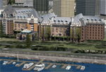
FSX-only version of Victoria, Canada area scenery including the Southern Gulf Islands and the San Juan Islands of the US. Includes automated installer and configurator by Scot Fraser.
Features:
-accurate shorelines, lakes and streams;
-landclass;
-FSX multi-LOD mesh with 10m maximum resolution;
-complete road network with moving traffic;
-railroads;
-utility corridors;
-marinas and ferry terminals;
-many static boats, including a custom model of the Canada Coast Guard ship Sir Wilfred Laurier;
-detailed models of major buildings and the Ogden Point Terminal;
-many bridges;
-nearly 300 marine lights; and corrected antennae locations.
Facilities include Don Grovestine's famous CYYJ (Victoria International Airport); 12 other Canadian land-based airports: Butler Field, Duncan (CAM3), Gaines, Hastings, Hudson Island, James Island, Thomas, Village Bay, Raven Field (CML2), Saltspring, Sidney Island, Whiskey Point; 20 US airports Blakely (38WA), Burden (61WA), Center Island (79WA), Clam Harbor (WA35), Crane Island, Decatur Shores (WN07), Decatur-Jones (WA18), Waldronaire (90WA), Orcas Island (KORS), Friday Harbour (KFHR), Lopez Island (S31), Pile Point, Roche Harbor (WA09), Shaw Island, Stuart Island Airpark (7WA5), Stuart Island West (2WA3), Wilding (6WA5), Windsock (4WA4); 12 floatplane facilities: Bedwell (CAB3), Fisherman's Bay (WA81), Friday Harbor (W33), Ganges (CAX6), Maple Bay, Mayne (CAW7), Port Washington (CAP8), Roche Harbor (W39), Rosario (W49), Shawnigan Lake (CAV8), Victoria Harbour (CYWH), Victoria International (CAP5) and Westsound, Orcas (WA83) - many with AI traffic; 9 heliports: Ganges (CAL7), Mayne (CBF5), Camel Point (CBF7), Jubilee (CBK8), Victoria General (CBW7) Madrona Bay (CBW9), Shoal Point (CBZ7), Mount Belcher (CMBH).
AI models include the DHC-2 floatplane in local liveries, a cruise ship model (by Mitsuya Hamaguchi) and two repaints, pilot boat, and small boats (by Larry Silsbee).
Ultimate Terrain X compatible (not required). Users of Vancouver+ for FSX will also get additional cruise ship traffic and additional floatplane and helicopter traffic. Full documentation. By Don Grovestine, Jon Patch and Holger Sandmann. Many other contributors: see documentation. Part 1 of 2 - you also need file vicenh7b.zip
| Filename: | Victoria_Canada_including_US_Southern_Gulf_Islands.zip |
| License: | Check within download |
| Added: | 29th January 2010, 21:23:17 |
| Downloads: | 23,158 |
| Author: | Don Grovestine, Jon Patch and Holger Sandmann |
| Size: | 56.8 MB |
| Category: Flight Simulator 2004 - Scenery | |
| The Victoria Falls of the Zambezi River, Zambia/Zimbabwe |
|
File Description:
One of the main landmarks of Africa, the spectacular Victoria Falls of the Zambezi River are missing in out-of-the-box FS. With a local SRTM LOD9 mesh as a base (included) and the help of satellite imagery, maps, Ground2K4, and GMax, we did our best to model a realistic representation of the falls, the river, and the gorge, complete with custom waterfall and spray effects. The portion of the Zambezi covered in this project extends from E25 to E26.5 (more than 100km), with the falls at its center. Also included is a replacement landclass file for an area of about 20km on either side of the Zambezi River and an optional AI boat (by Lynn and Bill Lyons) cruising on the Zambezi above the falls. Tested with FS2004 only but most scenery enhancements (not the AI boat) should work just as well in FS2002.
| Filename: | The_Victoria_Falls_of_the_Zambezi_River_ZambiaZimb.zip |
| License: | Freeware, limited distribution |
| Added: | 8th May 2004, 02:45:30 |
| Downloads: | 19,139 |
| Author: | Holger Sandmann and Johan van Wyk, Aeroworx |
| Size: | 3.5 MB |
| Category: Flight Simulator 2004 - AI Aircraft | |
| Malév Hungarian Airlines Bombardier CRJ-200 |
|
File Description:
MALEV Hungarian Airlines textures for the CDAI (Charles Dayhuff) CRJ-200 AI model (cdai_crj200_v3update.zip here at Avsim). Painted on an all-new paintkit by Holger Bachert.
| Filename: | Malv_Hungarian_Airlines_Bombardier_CRJ200.zip |
| License: | Freeware, limited distribution |
| Added: | 8th April 2007, 01:33:27 |
| Downloads: | 2,247 |
| Author: | Andrew Langille |
| Size: | 271.45 KB |
| Category: Flight Simulator 2004 - AI Aircraft | |
| Monarch Airbus A300-600 fleet pack |
|
File Description:
Texture pack for the FSP A300-600 on a modified version of Holger Bachert's paintkits. This pack features all livery versions for Monarch's fleet of 4 A300-600s
| Filename: | Monarch_Airbus_A300600_fleet_pack.zip |
| License: | Freeware, limited distribution |
| Added: | 1st August 2007, 11:41:21 |
| Downloads: | 1,531 |
| Author: | Garry Lewis |
| Size: | 3.21 MB |
| Category: Flight Simulator 2004 - AI Flight Plans | |
| Linhas Aereas de Mocambique - LAM Winter 2008 |
|
File Description:
Winter 2008 flightplans for Linhas Aereas de Mocambique - LAM (Maputo - Mozambique).
Fleet is: 1 Boeing B737-200;
2 BAe Jetstream JS41 (Moçambique Expresso).
LAM operates between cities from Mozambique (Maputo, Beira, Chimoio, Inhambane, Lichinga, Nampula, Pemba, Quelimane and Tete), Kenya (Nairobi), South Africa (Johannesburg) and Tanzania (Dar-es-Salaam).
Repaint: (On Avsim.com)
B732 -> aia_737_200_lam.zip by Holger Bachert;
JS41 (C9-AUK) -> djcai_js41_lam.zip by Holger Bachert;
JS41 (ZS-OMF) -> zs-omf.zip by Ralf Maylin.
| Filename: | Linhas_Aereas_de_Mocambique__LAM_Winter_2008.zip |
| License: | Freeware |
| Added: | 23rd November 2008, 11:31:06 |
| Downloads: | 424 |
| Author: | Francois Massin |
| Size: | 10.73 KB |
| Category: Flight Simulator 2004 - Scenery | |
| Vancouver Island and Inner Passage float bases in BC, Canada |
|
File Description:
This is a series of float bases to the east of the northern part of Vancouver Island. They are all zipped together because: first, they are all in the same geographical area and if you like one you may like them all; second it means I only write one set of notes; and third I only upload once. I was looking to fill in the gap between what Holger Sandmann and his cohorts have done with Alaska, and Vancouver and Vancouver Island to the south, and there are these 16 float bases in a stretch of 180 miles between the northern part of Vancouver Island and the mainland coast. And if you leave out the relatively isolated Rivers Inlet to the north then they are all within a 140 mile stretch. Some are on the east coast of Vancouver Island, but most are on islands between the mainland and the island.
| Filename: | Vancouver_Island_and_Inner_Passage_float_bases_in_.zip |
| License: | Freeware |
| Added: | 3rd August 2008, 06:03:09 |
| Downloads: | 1,870 |
| Author: | Roger Wensley & Jim Turner |
| Size: | 6.85 MB |
© 2001-2026 AVSIM Online
All Rights Reserved
Privacy Policy |