
Where Flight Simulation Enthusiasts Gather from Around the World!
AVSIM Library - Search Results

| Category: Flight Simulator 2004 - Scenery | |
| Driftwood Bay AK23 near Dutch Harbor Alaska |

|
Images related to this file:
File Description:
This is Driftwood Bay, an Air Force field that is just 13 miles northwest of Dutch Harbor, and was once part of a DEW line station with a road heading up the hill.
In FS9 the stock runway is concrete and if you have a mesh with the hills correctly positioned then the runway sits in a deep hole on the hillside. In fact the runway is gravel, 3,500 feet long and aligned 32/14 next to the beach, which is where I moved it to. The beach, as configured by Ultimate Terrain (and contrary to my previous doubts, UT does cover the Aleutians) is incorrect, in that a marshy area just behind the beach is shown as sea with large indentations in what should be a fairly straight line of sand. However, this does not squeeze AK23 in any way so I left it; consider it to be a spring high tide. There is very little at AK23 beyond a gravel runway and a windsock and the AI is an Alaska State Troopers Piper Super Cub from Dutch Harbor, presumably monitoring the numerous Alaska Maritime National Wildlife Refuge areas.
| Filename: | Driftwood_Bay_AK23_near_Dutch_Harbor_Alaska.zip |
| License: | Freeware, limited distribution |
| Added: | 14th August 2012, 20:32:14 |
| Downloads: | 352 |
| Author: | Roger Wensley, Sidney Schwartz |
| Size: | 3.35 MB |
| Category: Flight Simulator 2004 - Scenery | |
| Alaska North Slope 6; Oliktok POLI |
|
Images related to this file:
File Description:
Oliktok is a DEW station Air Force base to the east of the Colville River delta, 160 miles east of Barrow and 12 miles from Harmon Helmericks house and dirt strip in the delta on Anachlik Island. (See my previous post, made after reading his book about northern Alaska flying). The runway is just over 4,000 feet of gravel and aligned 03-21. The large hangar is still there, and so are the majority of the DEW buildings closer to the beach. There are now also some oil production facilities and living quarters nearby on the point, but these are not included in this scenery as to make them convincingly (and there is no point in making them unconvincingly!) would be 100+ times as laborious as making the airstrip. And as Sid has memorably said, "If you can't taxi up to it, then xxxx it". So this scenery is dated way before the north slope was changed from a wilderness to an industrial complex. The AI is one day a C-130, on another a Cessna, and on a third a Reeve Aleutian DC-6B.
| Filename: | Alaska_North_Slope_6_Oliktok_POLI.zip |
| License: | Freeware, limited distribution |
| Added: | 30th June 2016, 20:36:34 |
| Downloads: | 281 |
| Author: | Roger Wensley |
| Size: | 2.42 MB |
| Category: Flight Simulator 2004 - Scenery | |
| Paulatuk CYPC in the Northwest Territories, Canada |
|
Images related to this file:
File Description:
Paulatuk is on the coast of northern mainland Canada, 200 miles east of Tuktoyaktuk and 170 miles southwest of Ulukhaktok. It is just to the east of the Parry Peninsula, which has at its northern tip the Cape Parry DEW line Main Station. Paulatuk was established in the 1920's, and the population now numbers around 320. Paulatuk airfield is close to the village but on higher ground, while the village follows the curve of the coast. The 4,000 feet of 100 feet wide gravel runway is aligned 021T/201T where T stands for "true" as opposed to magnetic in the Northern Domestic Airspace. Only JETA-1 is available unless there is 100LL in drums. There are flights by Aklak Air from Inuvik, which is around 250 miles to the west; Aklak Air is actually Kenn Borek under a diferent name. The AI is for a daily passenger flight, and for a cargo flight on Wednesdays. In the summer, float planes use the lake to the south of the village, but I have no information as to docks or any other facilities; probably there aren't any.
| Filename: | Paulatuk_CYPC_in_the_Northwest_Territories_Canada.zip |
| License: | Freeware, limited distribution |
| Added: | 3rd December 2012, 21:58:47 |
| Downloads: | 278 |
| Author: | Roger Wensley |
| Size: | 4.39 MB |
| Category: Flight Simulator X - AFCAD Files | |
| LQSA - Sarajevo Intl. Airport, Bosnia Herzegovina |
|
File Description:
Sarajevo International Airport (IATA: SJJ, ICAO: LQSA), also known as Butmir Airport, is the main international airport in Bosnia and Herzegovina, located 3.3 NM (6.1 km; 3.8 mi) southwest of the railway station in the capital city of Sarajevo in the suburb of Butmir. Since the Dayton Accord in 1996, the airport has welcomed a thriving commercial flight business which includes B&H Airlines, Austrian Airlines, Lufthansa, Jat Airways, Croatia Airlines, Turkish Airlines, Germanwings and others. In 2006, 466,186 passengers traveled through Sarajevo airport, compared to only 25,000 in 1996. In 2011 Sarajevo International Airport had 599,996 passengers which is more than all of the airports in Bosnia-Herzegovina had together and 6,5% more than in 2010. In 2012 the company has a slight decline in traffic. In 2005 the European branch of the Airports Council International awarded Sarajevo the award of Best Airport Under 1 Million Passengers. I just land in this airport, thank you to Sarajevo approach for a nice job. This file has the right coordinates, with runway 46 meters wide, apron and characteristics of the airport, airport vehicles and buildings.
| Filename: | LQSA__Sarajevo_Intl_Airport_Bosnia_Herzegovina.zip |
| License: | Freeware |
| Added: | 10th November 2012, 22:52:51 |
| Downloads: | 2,138 |
| Author: | Anwar Gonzalez |
| Size: | 4.44 MB |
| Category: Flight Simulator X - Scenery | |
| RAF Driffield |
|
File Description:
The site was first opened in 1918 by the Royal Air Force (RAF) under the name of RAF Eastburn, before closing in early 1920. However, in 1935 a new airfield was built for the RAF initially training bomber crews before closing in 1977 when the site was turned over to the Army for use as a driving school being renamed Alamein Barracks.
The army used Driffield as a driver training centre, until RAF Leconfield (which was also taken over by the Army in 1977) was enlarged to accommodate those who lived and trained at Driffield. In 1992, the RAF regained ownership of this historic aerodrome, naming it: RAF Staxton Wold – Driffield Site. Once again, the RAF ensign flew over Driffield, but not for long. In 1996, the RAF itself transferred its own personnel and facilities to RAF Staxton Wold, thus bringing an end to 60 years of service. On 28 June 1996, the RAF ensign was lowered for the last time, bringing to an end RAF Driffield. It is used as a CTC (cadet training centre) for army cadets and houses 873 Driffield Squadron air training corps
For a more detail history of this station follow the link: https://en.wikipedia.org/wiki/RAF_Driffield
| Filename: | RAF_Driffield.zip |
| License: | Freeware |
| Added: | 22nd February 2016, 18:56:29 |
| Downloads: | 346 |
| Author: | Terry Boissel |
| Size: | 1.35 MB |
| Category: Flight Simulator X - Scenery | |
| RAF Oulton - Norfolk, England |
|
File Description:
I did this scenery for a gentlemen in Canada whose father served at the station during the war I've lost his details but hope he'll pick the scenery up when he searches on line.
RAF Oulton is a former Royal Air Force Satellite airfield located 3 miles (4.8 km) west of Aylsham, Norfolk and 12.5 miles (20.1 km) northwest of Norwich, Norfolk, England.
The airfield was built over 1939 and 1940 as a bomber airfield with T2 type hangars and grass runways, the facility operating as a satellite airfield of nearby RAF Horsham St. Faith between July 1940 and September 1942 after which it operated as a satellite airfield of RAF Swanton Morley.
In September 1943 Oulton was transferred from 2 Group to 3 Group and closed to flying for re-construction as a heavy bomber base with concrete runways, taxiways and parking areas. The work was completed in April 1944 and the airfield transferred to No. 100 Group RAF. Flying operations ceased at the end of July 1945, after which it was taken over by RAF Maintenance Command which used it to store de Havilland Mosquitos until November 1947.
Third Party add-on's will be required to gain the best effect - see the readme file.
| Filename: | RAF_Oulton___Norfolk_England.zip |
| License: | Freeware |
| Added: | 18th November 2015, 14:08:12 |
| Downloads: | 237 |
| Author: | Terry Boissel |
| Size: | 17.25 KB |
| Category: Flight Simulator X - Scenery | |
| RNAS Twatt (HMS Tern) |
|
File Description:
Opened on the 1 April 1941 RNAS (HMS Tern) was used throughout the second world war by various Sqns of the Royal Navy undergoing training.
The station had 4 concrete runways with various hangers and the usual building associated with a military base. It was also the first unit in the UK to experience a helicopter crash when a Sikorsky helicopter getting ready for take off; hit a parked Blenheim.
The UK and Iceland where involved in what was called the cod wars in the early 1970s, and NATO was concerned that it would have to remove its bases from Iceland should the dispute escalate between the 2 countries and there was talk of Twatt becoming a NATO base. However, this did not happen and the idea was dropped.
There was also talk of the unit becoming a base for helicopters supporting the oil industry, however, as a result of the drop in oil prices during the 80s that idea was also dropped.
Most of the airfield has been returned to farming now with only the unique Control Tower and a handful of other building remaining.
NB: For more detailed history of this unit go to:-
https://canmore.org.uk/site/81752/twatt-airfield
| Filename: | RNAS_Twatt_HMS_Tern.zip |
| License: | Freeware |
| Added: | 30th January 2017, 02:56:37 |
| Downloads: | 143 |
| Author: | Terry Boissel |
| Size: | 18.84 MB |
| Category: Flight Simulator 2004 - Scenery | |
| Iloilo Airport ,Iloilo City, Philippines |
|
File Description:
Iloilo Airport is located in Iloilo City, Panay Island, Philippines. This local visayan airport is served by the following major domestic airlines: Philippine Airlines, Cebu Pacific and Air Philippines. This scenery features the most realistic replica of buildings located in the airport area such as the Main Terminal buildings, Control Tower, Crash and Fire Rescue Station, Philippine Air Force building, private hangars, shops, and commercial buildings including the SM City-Iloilo right in front of the airport area. SM City's parking area is generally filled with vehicles everyday that they are very visible at the ramp area of the airport at daytime and most especially visible glittering at nighttime.
This scenery also features the different commercial vessels serving Iloilo City such as WG&A Superferry, Sulpicio Lines, Negros Navigation, and Philippine Fastferry Corporation's Supercat and SeaAngels. These vessels are visible when flying from Iloilo to Bacolod City passing through the Guimaras Channel.
This scenery is designed with the combined efforts of Ver Walter Gulfan of Cebu City, Philippines and Manny Aquino of Surabaya, Indonesia. For suggestions or comments, please visit our Philippine Flightsimmers Group website at www.philskies.net or you may join our forum at www.philskies.net/forum.
RPVI AFCAD file included with aircrafts taking off at the middle of the runway!
| Filename: | Iloilo_Airport_Iloilo_City_Philippines.zip |
| License: | Freeware |
| Added: | 29th August 2003, 21:38:49 |
| Downloads: | 5,813 |
| Author: | Ver Walter Gulfan/Manny Aquino,Jr. |
| Size: | 5.83 MB |
| Category: Flight Simulator X - Scenery | |
| RAF Bodney - Norfolk, England |
|
File Description:
Originally built as an RAF Bomber Command station the airfield was grass-surfaced and located on slightly rolling land with a hard surface perimeter track.
Initially it was used by aircraft of No. 21 Squadron RAF and No. 82 Squadron RAF (No. 2 Group) Bomber Command. They carried operations over France and later the Netherlands and even Norway. Their Bristol Blenheim IVs were joined on occasions by, in May 1941, 90 Squadron evaluating its new Boeing Fortress Mk 1s some Handley Page Hampdens for mining operations. 90 Squadron suffered heavy casualties and the use of the Fortress I was discontinued. Towards October 1942, the Blenheims were changed to Lockheed Venturas but the squadron moved on to RAF Methwold before the Venturas were operational.
RAF Bodney was transferred to the United States Army Air Forces in the summer of 1943. Placed under the jurisdiction of VIII Fighter Command of Eighth Air Force, it was primarily the home of the 352d Fighter Group, the "Blue Nosed Bastards of Bodney". The unit briefly moved to Belgium in January 1945 due to the Battle of the Bulge, although it returned in April. It was closed after the 352d returned to the United States in November. Source: Wikipedia
| Filename: | RAF_Bodney__Norfolk_England.zip |
| License: | Freeware |
| Added: | 9th January 2016, 15:06:12 |
| Downloads: | 297 |
| Author: | Terry Boissel |
| Size: | 1.18 MB |
| Category: Flight Simulator X - Aircraft Repaints, Textures and Modifications | |
| "353rd Fighter Group" North American AT-6 |
|
Images related to this file:
File Description:
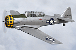
This is a repaint for the payware A2A Simulations AT-6 Texan. This repaint depicts the restored AT-6D 44-81506, owned by David Nock in the UK, registered as G-TDJN, and based at Halfpenny Green airfield. This particular aircraft was originally built for the USAAF in 1944, and in 1951 it was one of a hundred AT-6D's loaned to the RCAF, where it was operated until 1953. The aircraft was then acquired by the Panamanian AF, where it remained until 1967 when it was imported back into the US, at which time it was registered N7231C. David Nock acquired the aircraft in 2009 and had the US-based company Midwest Aero Restorations (noted for their authentic Mustang restorations) perform a full restoration on the aircraft. Completed in 2011, the aircraft won the Reserve Grand Champion WWII award at Oshkosh that year. The aircraft was restored in the authentic markings of AT-6D 43-13048, which was operated as a station hack by the 353rd Fighter Group during WWII, based at Raydon, England. The aircraft was imported into the UK in 2012, where it was re-registered as G-TDJN. Both UK and US registration options are provided with this repaint.
| Filename: | 353rd_Fighter_Group_North_American_AT6.zip |
| License: | Freeware |
| Added: | 10th April 2016, 19:54:39 |
| Downloads: | 243 |
| Author: | John Terrell |
| Size: | 66.67 MB |
© 2001-2026 AVSIM Online
All Rights Reserved
Privacy Policy |