
Where Flight Simulation Enthusiasts Gather from Around the World!
AVSIM Library - Search Results

| Category: Flight Simulator 2004 - Aircraft Repaints, Textures and Modifications | |
| U.S. Navy Convair T-29B |

|
Images related to this file:
File Description:
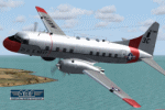
Convair T-29B (240-27) "Flying Classroom", tn 51-7906, cn 318, in Markings of U.S. Navy, Training Squadron 29 (VT-29), Naval Air Station Corpus Christi, Texas, 1966. Delivered to U.S. Air Force in 1953. Transferred to U.S. Navy on January 29, 1963. Withdrawn from use and stored at Davis Monthan Air Force Base, Arizona in April 1976. For preservation donated to Pima Country Air Museum on August 26, 1981 and placed on display. Textures and associated model file included only. Requires cv240VBFmilitary_basepack_010.ZIP. Original by Greg Pepper & Tom Gibson, upgraded by Georg Hauzenberger (model) and Hans Hermann (textures) Virtual Birds Factory, September 2010
| Filename: | US_Navy_Convair_T29B.zip |
| License: | Freeware, limited distribution |
| Added: | 15th September 2010, 21:40:26 |
| Downloads: | 495 |
| Author: | Georg Hauzenberger and Hans Hermann |
| Size: | 4.16 MB |
| Category: Flight Simulator 2004 - Scenery | |
| Burns Lake CYPZ in British Columbia, Canada |
|
Images related to this file:
File Description:
Burns Lake is 90 miles east of Terrace and 130 miles west of Prince George, on the eastern side of the Coast Mountains. The airfield is at 2343' ASL and the 11/29 runway is just over 7,000' of 75' wide asphalt. There are buildings, some of them new, around the apron at the west end of the runway and both JetA and 1100LL are available. There is also a weather station in a fenced area west of the apron. All apron buildings were modeled specifically for this scenery; there may be some missing if new construction has continued in the last three years.
| Filename: | Burns_Lake_CYPZ_in_British_Columbia_Canada.zip |
| License: | Freeware, limited distribution |
| Added: | 11th May 2011, 16:57:44 |
| Downloads: | 467 |
| Author: | Roger Wensley |
| Size: | 4.57 MB |
| Category: Flight Simulator 2004 - Scenery | |
| CJN4 Assiniboia Saskatchewan, Canada |
|
Images related to this file:
File Description:

Assiniboia Airport is located 11 km (7 miles) north of the town of Assiniboia in south central Saskatchewan, Canada. The airport is situated on the site of the wartime aerodrome built as part of the British Commonwealth Air Training Plan.
CJN4 Assiniboia was constructed using GMAX. It includes photo-real custom models of all the buildings at the airport, runway signs, refueling facilities, weather station, vehicles, runway and taxiway lighting and a rotating beacon. It also includes custom ground textures to replicate the crumbling decommissioned runways and cracked tarmac. The scenery replicates the pilot activated ARCAL lighting of airfield approach lights, edge lights, runway and taxiway lights.
| Filename: | CJN4_Assiniboia_Saskatchewan_Canada.zip |
| License: | Freeware |
| Added: | 4th September 2010, 19:13:59 |
| Downloads: | 1,053 |
| Author: | Gregory Putz |
| Size: | 9.11 MB |
| Category: Flight Simulator 2002 - Scenery | |
| Newburgh Stewart International KSWF V1.0 |
|
File Description:
Newburgh, NY's Stewart International Airport. Scenery includes gates, static aircraft and ground vehicles, custom buildings integrated into FS2002's default buildings when set to high density. You'll find a nice terminal with a start location at one of the two gates, a maintenance hangar and offices for WWAL, an FBO, fire station, 105th Airlift Sqdrn, Army helicopters, and other eye candy. Includes a lite file with no static aircraft for those who perfer not to use them. Also incudes a radio navigation course to test your VOR and NDB navigation skills, with floating targets to confirm checkpoints. Requires NOVA textures, a freeware download. By Kyle Ramsey, tested in FS2002 only.
| Filename: | Newburgh_Stewart_International_KSWF_V10.zip |
| License: | Freeware, limited distribution |
| Added: | 21st December 2002, 04:27:27 |
| Downloads: | 1,054 |
| Author: | Kyle Ramsey |
| Size: | 3.11 MB |
| Category: Flight Simulator X - Helicopters | |
| Royal Navy EH101. 824 NAS, RNAS Culdrose |
|
Images related to this file:
File Description:
This is a repaint for the default FSX Acceleration EH101 Merlin, depicting a 'Cab' used 824 Naval Air Squadron of RNAS Culdrose during the summer of 2009. The Merlin training unit, 824 NAS's HM.1s are a very regular site around west Cornwall. Especially south of the base on the Lizard Peninsula, on the short flight path between Culdrose and its satellite airfield, Predannack. A former RAF station in its own right. This is obviously a fictitious repaint as the FSX Merlin is modelled on the transport variant (HC.3 in RAF service) as opposed to the maritime patrol HM.1. By Ash Jackson
| Filename: | Royal_Navy_EH101_824_NAS_RNAS_Culdrose.zip |
| License: | Freeware |
| Added: | 9th November 2009, 18:19:52 |
| Downloads: | 875 |
| Author: | Ashley Jackson |
| Size: | 3.17 MB |
| Category: Flight Simulator X - Scenery | |
| KSYR - Syracuse Hancock Intl - New York, USA |
|
Images related to this file:
File Description:
This airport update is made only for FSX with two optional files, one version with the Crosswind runway activated and in full operation where both runways will be used for takeoff and landing and one version as the default runway operation: airlines assigned to their correct gates, extra military and GA parking, taxiways and taxi signs now updated to the latest charts, terminal completely remodeled, cargo apron expanded with their buildings, extra fuel trucks, support vehicle roads rebuilt, fire station, Best Western Inn also included and many other scenery objects added, airport views are from the roof of the control tower (when in tower view) please view the readme before installation.
| Filename: | KSYR__Syracuse_Hancock_Intl__New_York_USA.zip |
| License: | Freeware, limited distribution |
| Added: | 7th March 2014, 12:38:39 |
| Downloads: | 9,544 |
| Author: | Craig Scott |
| Size: | 663.61 KB |
| Category: Flight Simulator 2004 - Scenery | |
| Barbados International Airport |
|
Images related to this file:
File Description:

Grantley Adams International Airport for FS2004 (Re-uploaded + 1.1 update included)
This scenery represents a complete redevelopment of the stock FS2004 airport and reflects the state of the airport in 2007/2008. Features 3D models of the main terminals made in GMAX plus cargo area, fire station, Concorde Experience Museum and other ancillary structures in the airport property and beyond, photoreal ground polygons designed in GMax, 3D taxi lighting and approach lighting system for Runway 09, small Landclass update for Bridgetown and surrounding districts to bring in line with real life geography. ** FS2004 ONLY ** See FSX Library for the FSX version. Enjoy your visit to sunny Barbados!
| Filename: | Barbados_International_Airport.zip |
| License: | Freeware, limited distribution |
| Added: | 13th December 2009, 03:31:53 |
| Downloads: | 16,932 |
| Author: | Max Kraus |
| Size: | 66.73 MB |
| Category: Flight Simulator X - Scenery | |
| RAF Elsham Wold |
|
File Description:
In the late 1930s with a new war on the horizon, extra airfields were again needed to accommodate an expansion of the RAF. Former First World War stations were surveyed for suitability, and an area just to the west of the original Elsham site was deemed to be better suited. work began in the winter of 1939-1940, and the station opened with the arrival in July 1941 of 103 Squadron. The station was equipped with a main runway 2,000 yards (1,829 m) long, and two subsidiaries of 1,600 yards (1,463 m) and 1,400 yards (1,280 m). Three hangars (two T-2's and one J-Type) and 27 aircraft hardstands (later increased to 36) were built. Three more T-2 hangars were built in 1944. Accommodation for around 2,500 personnel was dispersed in the nearby farmland.
No. 103 is credited with more operational sorties than any other 1 Group squadron, and consequently suffered the group's highest losses. Of the 248 bombers lost on operations flying from Elsham Wolds, 198 were from No. 103 Squadron. By type, losses were 28 Vickers Wellingtons, 12 Halifaxes and 208 Lancasters. One Elsham Wolds Lancaster, Lancaster III ED888 M2 (Mike Squared)[3] which served with both Nos. 103 and 576, held the Bomber Command record for operational sorties, having completed 140 between May 1943 and December 1944.[4] A total of 974 operational hours. Source: Wikipedia.
| Filename: | RAF_Elsham_Wold.zip |
| License: | Freeware |
| Added: | 17th October 2015, 10:26:14 |
| Downloads: | 333 |
| Author: | Terry Boissel |
| Size: | 17.4 KB |
| Category: Flight Simulator 2004 - Scenery | |
| Kugaaruk CYBB and DEW Pelly Bay CWPB in Nunavut, Canada |
|
Images related to this file:
File Description:
Kugaaruk is on the coast of northern mainland Canada on the Boothia Peninsula, 60 miles into a deep north-south fjord-like inlet called Pelly Bay. The name was changed from Pelly Bay in 1999, and the population is around 800. Gjoa Haven is 150 miles to the west, and Hall Beach just over 200 miles to the east. Six miles south of the village, and connected by a gravel road, there is a NWS station and what remains of a DEW Auxiliary Site; the DEW site was closed in 1992, a year after the NWS station became operational. There is also a 3,350 feet long gravel runway beside Barrow Lake 2 miles east of the site, Pelly Bay CWPB. Kugaaruk airfield is adjacent to the village and the 5,000 feet of 100 feet wide gravel runway is aligned 049T/229T where T stands for "true" as opposed to magnetic. There are flights by First Air and Canadian North and the AI includes a daily flight of each from Yellowknife via Gjoa Haven (as per real life) plus a cargo visit by Buffalo. Although the runway is long enough to accomodate a 737 it is not licensed for regular scheduled jet flights; the reason for this is that the approach lighting is "inadequate". Included here is a new .bgl for Gjoa Haven which will remove the small hold short line from the gravel; my mistake.
| Filename: | Kugaaruk_CYBB_and_DEW_Pelly_Bay_CWPB_in_Nunavut_Ca.zip |
| License: | Freeware, limited distribution |
| Added: | 25th November 2012, 00:43:07 |
| Downloads: | 428 |
| Author: | Roger Wensley |
| Size: | 6.1 MB |
| Category: Flight Simulator X - Scenery | |
| RAF Waterbeach, Cambridgeshire 1943 |
|
File Description:
RAF Waterbeach (ICAO X3WH)is a former Royal Air Force station located in Waterbeach, Cambridgeshire which is 5.5 miles (8.9 km) north of Cambridge. The site was then used by the Royal Engineers, part of the British Army, from 1966, as Waterbeach Barracks until 2013 when the site closed to make way for housing. The site is currently unoccupied, apart from the officers' houses still in use - though Urban & Civic are now looking at temporary uses.
The airfield was built in 1940 on the northern edge of Waterbeach village and operated under the control of RAF Bomber Command. The original control tower and many RAF buildings, including several hangars, are still present
Source: Wikipedia
| Filename: | RAF_Waterbeach_Cambridgeshire__1943.zip |
| License: | Freeware |
| Added: | 11th May 2016, 20:27:00 |
| Downloads: | 143 |
| Author: | Terry Boissel |
| Size: | 1.34 MB |


© 2001-2026 AVSIM Online
All Rights Reserved
Privacy Policy |