
Where Flight Simulation Enthusiasts Gather from Around the World!
AVSIM Library - Search Results

| Category: Flight Simulator 2004 - Scenery | |
| Abeid Amani Karume International Airport (HTZA) V2 |

|
Images related to this file:
File Description:
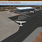
Thanks for downloading ABEID AMANI KARUME INTERNATIONAL AIRPORT (HTZA) V2 for FS2004. This is the main International Airport in Zanzibar, Tanzania. The Airport scenery was built from Sketchup, SBUILDER, Fencebuilder Pro and ADE utilizing Google Earth for correct positions. Objects placed with Instant Scenery 3. This is version 2, it includes Terminal 1(old colonial terminal), Terminal 2, terminal 3 (new), Fire Station and GA Hangar and facility areas. . Needs RWY12 Object library (download it in avsim.com or flightsim.com or just google it :)) to see all the objects.
| Filename: | Abeid_Amani_Karume_International_Airport_HTZA_V2.zip |
| License: | Freeware |
| Added: | 20th August 2021, 04:58:42 |
| Downloads: | 534 |
| Author: | EMMANUEL P MWANDOSYA |
| Size: | 17.39 MB |
| Category: Microsoft Flight Simulator (2020) - Original Aircraft | |
| Lisunov Li-2 |
|
File Description:
Lisunov Li-2 for FSX acceleration, or FSX steam. Lisunov LI-2 is the Soviet licensed version of the American DC-3. The plane includes vc-cockpit, cabin, and a fictional radio operator station. Textures: CSA, LOT, TAROM, AEROFLOT, CAAC, PLAAF, VVS, Czechoslovak air force, and the rest of the liveries have Hungarian cockpits (Malev, Hungarian air force,). This is my first project. Sounds are made by Gary Jones used with his permission, xml sound file created by, Doug Dawson. The mod works with fsx steam edition or, fsx acceleration.
| Filename: | Lisunov_Li2.zip |
| License: | Freeware, limited distribution |
| Added: | 8th May 2021, 17:41:17 |
| Downloads: | 280 |
| Author: | Dániel Schweitzer |
| Size: | 56.59 MB |
| Category: Flight Simulator X - Scenery | |
| EGBB - Birmingham Airport - Birmingham, UK |
|
Images related to this file:
File Description:
This scenery update is for Birmingham airport and made only for FSX: Assigned parking as per their website, runway 15/33 now at its new length, runway 6/24 decommissioned and now taxiway T and L, the A45 moved to its new location including the new perimeter road, new ATC tower and associated buildings, taxiways and taxi signs updated to the latest charts, new Monarch hangar, fire station added and many other scenery objects included, airport views are from inside the new control tower (when in tower view) please view the readme before installation.
| Filename: | EGBB__Birmingham_Airport__Birmingham_UK.zip |
| License: | Freeware, limited distribution |
| Added: | 24th May 2015, 12:48:20 |
| Downloads: | 24,318 |
| Author: | Craig Scott |
| Size: | 1.12 MB |
| Category: Flight Simulator X - Scenery | |
| KNHK - NAS Patuxent River - Patuxent River, MD |
|
Images related to this file:
File Description:

By request, here is an improved version of the stock NAS Patuxent River. I added Military_Cargo and Military_Combat parking spaces. I added the fire station and fire trucks. I removed and replaced many default buildings, added additional buildings, and added the control tower. Added static fuel trucks, static airplanes and helicopters, parking lots with cars and light poles. Added, removed, or adjusted taxiways and aprons as needed. I moved one apron to be compatible with the Ultimate Terrain coastline, but it should also be fine with default scenery.
| Filename: | KNHK__NAS_Patuxent_River__Patuxent_River_MD.zip |
| License: | Freeware |
| Added: | 10th June 2010, 00:52:06 |
| Downloads: | 2,593 |
| Author: | Jim Cook |
| Size: | 17.37 KB |
| Category: Flight Simulator 2004 - Scenery | |
| EGVL - RAF Little Rissington - Gloucestershire, England |
|
Images related to this file:
File Description:
Representative scenery of RAF Little Rissington in Gloucestershire.
RAF Little Rissington (ICAO: EGVL) is an RAF aerodrome and former RAF station in Gloucestershire, England. It was once home to the Central Flying School, the Vintage Pair and the Red Arrows.
Built during the 1930s, the station was opened in 1938 and closed in 1994. The married-quarters and main technical site were sold in 1996 (the former becoming the village of Upper Rissington), but the aerodrome has been retained by the Ministry of Defence and remains active along with the southern technical sites, under the operational control of No.2 Flying Training School at RAFC Cranwell.
It is now home to 637 Volunteer Gliding Squadron as the primary military unit, who provide elementary flying training for Combined Cadet Force and Air Training Corps cadets. The airfield is also used by the forces as a relief landing ground, training area and parachute dropping area. In previous years, the Royal Air Force estate has been used as a film set, including The Avengers, part of the ice chase in Die Another Day, and the Thunderbirds film.
This scenery has been made using various scenery libraries, mainly from MAIW. Full listing in the docs.
| Filename: | EGVL__RAF_Little_Rissington__Gloucestershire_Engla.zip |
| License: | Freeware, limited distribution |
| Added: | 28th July 2014, 09:17:31 |
| Downloads: | 1,058 |
| Author: | Brian Clarke, Daryl Payne, Stewart Pearson |
| Size: | 448.92 KB |
| Category: Prepar3D V5 - Scenery | |
| VOMM_P3Dv5 |
|
File Description:
Chennai International Airport (IATA: MAA, ICAO: VOMM) is an international airport serving the city of Chennai, Tamil Nadu, India, and its metropolitan area. It is located in Tirusulam, 21 km (13 mi) from the city centre. Chennai International Airport is the third busiest in international traffic and cargo capacity in the country behind New Delhi and Mumbai.[4][5] It is also 49th busiest airport in Asia making it one of the four major airports in India under the top 50 list.[6] The airport is served by the airport metro station of the Chennai Metro and the Tirusulam railway station of the Chennai Suburban Railway system. To cope with the passenger traffic, two new terminals, namely, T2 and one satellite terminal, are under construction to handle 40 million passengers per year.[7] Once completed, it will be India's first airport to have a satellite terminal. The new satellite terminal will be connected through a four way underground walkalator for passenger movement across different terminals.[8] Still, the Tirusulam airport complex is expected to reach saturation by 2035, with a peak capacity of 40 million passengers, and a proposal for a new greenfield airport in Chennai is underway for decades. Once the new airport is commissioned, both the airports will be functional.
| Filename: | VOMM_P3Dv5.zip |
| License: | Freeware |
| Added: | 20th October 2020, 23:18:27 |
| Downloads: | 1,380 |
| Author: | Abhishek Banerjee |
| Size: | 14.68 MB |
| Category: Flight Simulator 2004 - Scenery | |
| PAAT (ATU) - Attu - Alaska, USA |
|
Images related to this file:
File Description:
Attu is AT the western end of the Aleutian chain of islands in Alaska, around 40 miles west of Shemya. There was small village on Attu before the Japanese invasion in mid 1942, but the island is now uninhabited. The Coast Guard Loran navigation station remains in place, though it is no longer in operation and visitors to the island are now either tourists or wildlife experts conducting surveys of numbers of nesting birds, etc. The runway still usable is aligned 02-20 and 5,800 feet long; right hand circuits on 02 to stay away from rising ground to the west. The "terminal" building has lost its sign regarding the Horny Bird, removed in 2010 by one of the last of the station operators, but the building is still there, as are some sheds and shacks that lately were used for the uncomfortable accommodation of bird counters. FS9 has used an incorrect icao identification for Attu but correcting it now would make life complicated so ATU it is and shall remain. I have removed the default FS9 roads that came complete with streetlights and telephone poles and replaced and amended the layout with gravel roads to better resemble real life, though the island shape is at best approximate, as is usual in FS9.
| Filename: | PAAT_ATU__Attu__Alaska_USA.zip |
| License: | Freeware, limited distribution |
| Added: | 2nd March 2015, 20:58:09 |
| Downloads: | 280 |
| Author: | Roger Wensley |
| Size: | 3.27 MB |
| Category: Flight Simulator X - Scenery | |
| RAF Stenigot |
|
File Description:
RAF Stenigot was a Second World War radar station situated at Stenigot, near Donington on Bain, Lincolnshire.
It was part of the Chain Home radar network, intended to provide long range early warning for raids from Luftflotte V and the northern elements of Luftflotte II along the approaches to Sheffield and Nottingham and the central midlands.
I would like to give credit and to acknowledge the following authors without whose work I could not have made this scenery; all credit for the models contained in it is theirs I merely placed it. Ted Andrews - Ian Pearson - Mike Hudson.
| Filename: | RAF_Stenigot.zip |
| License: | Freeware |
| Added: | 3rd October 2015, 18:50:05 |
| Downloads: | 309 |
| Author: | Terry Boissel |
| Size: | 130.31 KB |
| Category: Flight Simulator 2004 - Scenery | |
| Edinburgh Island, FOX-2, Horton River, Igloolik, & Kimmirut, adapted for the FSGenesis 76m North Canada Terrain Mesh |
|
Images related to this file:
File Description:
These are replacement bgl's to convert five northern Canada fields for use with the FSGenesis 76m terrain mesh for northern Canada. The five are Edinburgh Island CWEI, the FOX-2 DEW line station, Horton River CWHR, Igloolik CYGT, and Kimmirut CYLC. These are not stand-alone, and the presumption is that you have already downloaded and installed the previously posted sceneries. This installation consists solely of replacing the existing scenery bgl's with the new. There will be further posts of northern airfields in groups of five, alphabetically, and observations regarding the amendments and any further corrections that are required would be welcomed.
| Filename: | Edinburgh_Island_FOX2_Horton_River_Igloolik__Kimmi.zip |
| License: | Freeware, limited distribution |
| Added: | 10th September 2017, 19:29:57 |
| Downloads: | 86 |
| Author: | Roger Wensley |
| Size: | 3.55 MB |
| Category: Flight Simulator X - Aircraft Repaints, Textures and Modifications | |
| Royal Air Force Islander BN-2 |
|
Images related to this file:
File Description:
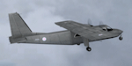
Repaint for the payware FSX Britten-Norman BN2 from Flight1 in the colors of Britain's Royal Air Force (RAF). This repaint represents an Islander CC2 of the RAF Northolt Station Flight in London. Islander gray instrument panel by Frank Safranek (BN-2_GRAY_PNL.ZIP) is recommended. Please note the CC2 is a version of the three-bladed, turbine-engined BN-2T. However the Flight1 models are BN-2A and BN-2B two-bladed, piston-engined variants. The CC2 is also fitted with a radar altimeter, infra-red line scanner (IRLS) and vertical cameras, none of which are modelled in the Flight1 variants.
| Filename: | Royal_Air_Force_Islander_BN2.zip |
| License: | Freeware, limited distribution |
| Added: | 26th May 2010, 03:26:55 |
| Downloads: | 524 |
| Author: | Andy Ford |
| Size: | 4.95 MB |
© 2001-2026 AVSIM Online
All Rights Reserved
Privacy Policy |