
Where Flight Simulation Enthusiasts Gather from Around the World!
AVSIM Library - Search Results

| Category: Flight Simulator 2004 - Scenery | |
| Vagar Airport |

|
File Description:
Vagar Airport (EKVG) is located on the Faroe islands, between Scotland and Iceland. Features include parkable hangars, accurate control tower, accurate buildings, many vehicles, car parks, cargo terminal, fire-station, boats, nearby villages and more. Many night textures and custom AFCAD file included. The airport is at N62* 03.8177' and W7* 16.6332'. This scenery is for FS2004 only.
| Filename: | Vagar_Airport.zip |
| License: | Freeware, limited distribution |
| Added: | 6th November 2005, 18:41:09 |
| Downloads: | 7,333 |
| Author: | Tim Clayton |
| Size: | 429.39 KB |
| Category: Flight Simulator 2004 - Scenery | |
| Princess Juliana Int'l (TNCM) |
|
Images related to this file:
File Description:
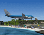
Princess Juliana Int'l Airport, v1.2. Scenery of TNCM, Princess Juliana International Airport of St-Maarten in the Netherlands Antilles. Adds an ILS on runway 9 though in reality Juliana airport is not equipped with this instrument. Adds the weather station, cars on the airport parking, extends the hill near Maho hotel and adds the Juliana heliport. By Delblond Christian.
| Filename: | Princess_Juliana_Intl_TNCM.zip |
| License: | Freeware |
| Added: | 8th June 2022, 00:35:24 |
| Downloads: | 713 |
| Author: | Delblond Christian |
| Size: | 4.76 MB |
| Category: Flight Simulator X - Scenery | |
| KLRF - Little Rock AFB - Jacksonville, AR |
|
Images related to this file:
File Description:

Here is an improved version of the stock Little Rock AFB. I added Military_Cargo parking spaces. I added the fire station and fire trucks. I removed and replaced many default buildings, added additional buildings, and moved the control tower. Added static fuel trucks, parking lots with cars and light poles. Added, removed, or adjusted taxiways and aprons as needed.
| Filename: | KLRF__Little_Rock_AFB__Jacksonville_AR.zip |
| License: | Freeware |
| Added: | 26th May 2010, 00:46:34 |
| Downloads: | 1,766 |
| Author: | Jim Cook |
| Size: | 15.89 KB |
| Category: Flight Simulator X - AFCAD Files | |
| McChord AFB - Tacoma, WA (KTCM) |
|
File Description:
Here is an improved version of the stock McChord AFB. I added many Military_Cargo parking spaces. I added the fire station and fire trucks. I removed and replaced most of the default buildings and added many additional buildings. Added static fork trucks, fuel trucks, parking lots with cars and light poles. Added, removed, or adjusted taxiways and aprons.
| Filename: | McChord_AFB__Tacoma_WA_KTCM.zip |
| License: | Freeware |
| Added: | 26th May 2008, 04:47:20 |
| Downloads: | 1,908 |
| Author: | Jim Cook |
| Size: | 15.55 KB |
| Category: Flight Simulator X - Scenery | |
| Toncontin International Airport (MHTG) v1 |
|
File Description:
This it an update of the default FSX airport of Toncontin, Tegucigalpa, Honduras. One of the most dangerous approach airport in the world.
2 jetways were added and other buildings as current true airport configuration. Themes with people and vehicles, fire station, etc were added to give some life to an otherwise "boring" FSX default airport.
| Filename: | Toncontin_International_Airport_MHTG__v1.zip |
| License: | Freeware |
| Added: | 26th January 2011, 14:43:55 |
| Downloads: | 2,772 |
| Author: | Joe Garcia |
| Size: | 242.94 KB |
| Category: Flight Simulator X - AFCAD Files | |
| Travis AFB - Fairfield, CA (KSUU) |
|
File Description:
By request, here is an improved version of the stock Travis AFB. I added many Military_Cargo and Military_Combat parking spaces. I replaced the fire station and added fire trucks, removed and replaced several improperly placed buildings and added additional buildings. Added static fork trucks, a parking lot with cars and light poles. Added, removed, or adjusted taxiways and aprons.
| Filename: | Travis_AFB__Fairfield_CA_KSUU.zip |
| License: | Freeware |
| Added: | 21st May 2008, 11:58:33 |
| Downloads: | 1,989 |
| Author: | Jim Cook |
| Size: | 28.65 KB |
| Category: Prepar3D V1-4 - Scenery | |
| Avezzano City and Space Station of Fucino Telespazio Avezzano(L'Aquila) Italy N41.58.43 E13.36.02 |
|
File Description:
Avezzano City and Space Station of Fucino Telespazio Avezzano(L'Aquila) Italy N41.58.43 E13.36.02 has been active since 1963 and today, with its 170 antennas and its 370,000 square meters of surface, is recognized as the first and most important "teleport" in the world civilian uses, Here are satellite orbit control activities, telecommunications, television and multimedia services, with engineers, specialized technicians and operational personnel operating at the COSMO-SkyMed Earth observation satellite observation center and one of the Control Centers (GCCs) that manage the European Galileo Navigation and Location System.In the scenery there is also the town of Avezzano.
Important VFR point for approaching airport Aquila Preturo and Avezzano city.
Within the downloaded package you will find readme files for scenery installation. Good fly VFR. Pasquale Marrulli.
| Filename: | Avezzano_City_and_Space_Station_of_Fucino_Telespaz.zip |
| License: | Freeware |
| Added: | 5th November 2017, 17:47:01 |
| Downloads: | 229 |
| Author: | Pasquale Marrulli |
| Size: | 3.84 KB |
| Category: Flight Simulator 2004 - Scenery | |
| Alternates for Durban Island CWFB FOX-E DEW line station in Nunavut, Canada |
|
File Description:
These are alternative bgls that include a flatten. They will change the shape of the hill that the FOX-E station sits on top of, but they will also make sure that there are no "floating" or "buried" scenery objects. If you are having that problem then just throw these into the scenery folder that you already created when you installed Durban Island, and say Yes! to over-write or whatever the question is. If you have a mesh that is compatible with what I use then you won't be having that problem, so don't do anything.
| Filename: | Alternates_for_Durban_Island_CWFB_FOXE_DEW_line_st.zip |
| License: | Freeware, limited distribution |
| Added: | 1st July 2011, 22:12:35 |
| Downloads: | 267 |
| Author: | Roger Wensley |
| Size: | 353.65 KB |
| Category: Flight Simulator 2004 - Scenery | |
| PABA - Barter Island (Kaktovik) - Alaska North Slope 8 |
|
Images related to this file:
File Description:
The town of Barrow is in the far north of Alaska, and these are coastal villages or radar installations to the west, south, and now east of Barrow. There will be further additions. Barter Island is a DEW station Air Force base 310 miles east of Barrow and 75 miles east of Bullen Point. The runway is just under 5,000 feet of gravel and aligned 06-24 on a spit of land at the northeast corner of the island. The big hangar is still there on the apron. Most of the DEW buildings have now been removed but this scenery is dated around 2005 when there were more of them still there. Between the DEW station and the airstrip is the village of Kaktovik, with a population of some 300 mainly traditional Inupiat. The village was first pioneered when the DEW station was built in the 1950's and grew as the years passed. The FS9 error discovered when making this scenery was that FS9 had mistakenly "placed" Kaktovik at Bullen Point (not physically, it was just wrongly stated as the local town); this is now only partly corrected as FS9 refused to accept my Bullen Point revision but allowed me to associate Kaktovik with Barter Island. Kaktovik is definitely on Barter Island. I could also mention that the runway was in the sea, but there isn't much point in that as Bill would say it was all the fault of Ultimate Terrain, so I won't bother. The next DEW station to the east is in Canada and called Komakuk; this has already been made and posted. The next in this series will be far to the west. The AI has daily flights by ERA, plus Northern Air Cargo, and some GA.
| Filename: | PABA__Barter_Island_Kaktovik__Alaska_North_Slope_8.zip |
| License: | Freeware, limited distribution |
| Added: | 19th July 2016, 17:49:16 |
| Downloads: | 208 |
| Author: | Roger Wensley |
| Size: | 3.42 MB |
| Category: Microsoft Train Simulator - Activities | |
| Marietta to Swik Passenger Run |
|
File Description:
It’s a cold winters day just a few days before xmas, The Swik locals locomotive has been reassigned due to the failure of another engine on a high priority run. So, pull the rs3 out of the shed and then back to in to the yard. Open the swich and couple to the four coaches, this will be the train. Then drive them down to Marietta station; stop at the platform to begin the run. When you arrive at Swik you arrive at the Swik branch you will need to use the switchbacks to lose the height to access the station. Note to those who are not familiar with the rs3, it was also designed to pull short passenger trains. Also note that the traffic in Marietta is crazy. A yellow signal can become a read signal in just a few seconds.
| Filename: | Marietta_to_Swik_Passenger_Run.zip |
| License: | Freeware |
| Added: | 24th October 2002, 02:55:47 |
| Downloads: | 1,188 |
| Author: | Peter j Weiss |
| Size: | 9.53 KB |
© 2001-2026 AVSIM Online
All Rights Reserved
Privacy Policy |