
Where Flight Simulation Enthusiasts Gather from Around the World!
AVSIM Library - Search Results

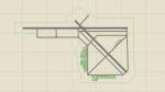
| Category: Flight Simulator 2004 - Scenery | |
| CWCP - Cape Parry - Northwest Territories, Canada |

|
Images related to this file:
File Description:
This is a DEW line Main Station on the shore of the Canadian mainland at the far northern tip of Cape Parry. It is 60 miles north of Paulatuk, which is at the base of the Parry Peninsula, and 120 miles south of Sachs Harbour on Banks Island. The station ceased operations in 1989 and a North Warning System automated station was opened in the same year; the NWS station is not shown in this scenery as I have no information regarding it's location or layout. The runway is just over 5,000 feet of gravel 150 feet wide, aligned 037T at an elevation of 119 feet ASL. There is a large apron with a large hangar and a small shelter building for passengers. There are of course no lights, signage, or windsock. The station is up on the hill at 210 feet ASL. This is one of the more interesting stations in terms of size and complexity.
| Filename: | CWCP__Cape_Parry__Northwest_Territories_Canada.zip |
| License: | Freeware, limited distribution |
| Added: | 25th December 2012, 19:07:24 |
| Downloads: | 302 |
| Author: | Roger Wensley |
| Size: | 1.61 MB |
| Category: Orbiter - Spaceships | |
| Pegasus |
|
File Description:
Pegasus: vehicle Lunar multifunction, with orbital capacity to transport load containers, to carry out exploration functions, investigation and to house diverse teams in their embryonic wings;
Pressing K The floodgate opens up for EVA
Pressing G t positions the radar antenna down to obtain information of the surface or forward for the sailing
Pressing J to disembark shipment container, this it can be: material of construction of the Lunar base, scientific team, fuel for their own consumption, or Laboratories.
| Filename: | Pegasus.zip |
| License: | Freeware |
| Added: | 16th January 2004, 21:17:51 |
| Downloads: | 598 |
| Author: | Salvadortega |
| Size: | 438.64 KB |
| Category: Flight Simulator X - Scenery | |
| RAF Strubby |
|
File Description:
RAF Strubby was located south east of the Lincolnshire Wolds town of Louth and south of the village from where the station got its name.
Opening in early 1944 the station lead a varied aircraft career being used by the USAAF as well as the RAF during the time it was operation. (For a more detailed history of the station the following web site is a wonderful source of information www.bcar.org.uk/strubby-history. The station closed for Military flying in 1972.
I would like to give credit and to acknowledge the following authors without whose work I could not have made this scenery; all credit for the models contained in it is theirs I merely placed it. Ted Andrews - Ian Pearson - Mike Hudson.
| Filename: | RAF_Strubby.zip |
| License: | Freeware |
| Added: | 3rd October 2015, 18:55:25 |
| Downloads: | 283 |
| Author: | Terry Boissel |
| Size: | 390.9 KB |
| Category: Flight Simulator X - Scenery | |
| RAF Wigsley |
|
File Description:
RAF Wigsley is a little know station just inside the border of Nottinghamshire, It had the standard layout of a bomber
airfield and was used as a satellite for RAF Swinderby.
For a more detailed account of this station Paul Marshal has written a very interesting piece at this link
http://www.harby.org.uk/RAFWigsley.htm
| Filename: | RAF_Wigsley.zip |
| License: | Freeware |
| Added: | 10th March 2017, 14:46:38 |
| Downloads: | 118 |
| Author: | Terry Boissel |
| Size: | 1.4 MB |
| Category: Flight Simulator 2004 - Scenery | |
| Valkenburg Naval Air Station (NAS) Bug Fix V1.1b |
|
File Description:
Small bugfix for my Vliegkamp Valkenburg (Naval Air Station)
Missing texturefile of some hangers. Requires ehvb-v11.zip
| Filename: | Valkenburg_Naval_Air_Station_NAS_Bug_Fix_V11b.zip |
| License: | Freeware, limited distribution |
| Added: | 18th September 2003, 16:41:46 |
| Downloads: | 2,648 |
| Author: | Marcel Ritzema |
| Size: | 77.98 KB |
| Category: Flight Simulator 2004 - Aircraft Repaints, Textures and Modifications | |
| Captain Sim HC-130 Air Station Kodiak Livery |
|
File Description:
Air Station Kodiak Livery for the Captain Sim Legendary C-130. This is the Coast Guard HC-130
| Filename: | Captain_Sim_HC130_Air_Station_Kodiak_Livery.zip |
| License: | Freeware |
| Added: | 12th November 2005, 14:48:27 |
| Downloads: | 4,750 |
| Author: | Brian Smith |
| Size: | 12.09 MB |
| Category: Flight Simulator X - AFCAD Files | |
| KNJK - El Centro Naval Air Station - El Centro, California |
|
Images related to this file:
File Description:
AFCAD file for the default KNJK El Centro Naval Air Station. Designed for and tested with MAIW traffic.
| Filename: | KNJK__El_Centro_Naval_Air_Station__El_Centro_Calif.zip |
| License: | Freeware |
| Added: | 4th May 2013, 15:09:20 |
| Downloads: | 492 |
| Author: | Chris Peschke |
| Size: | 49.27 KB |
| Category: Flight Simulator X - Scenery | |
| RAF High Ercall - Staffordshire, England |
|
File Description:
RAF High Ercall is a former Royal Air Force station situated near the village of High Ercall, seven miles north-east of Shrewsbury.
It was a post expansion station with work starting in 1938, however, personnel started arriving before it was fully finished in 1940. The unit had a variety of permanent buildings mainly located on the main unit site and the temporary accommodation and sick quarters were located on the south of the airfield.
The station closed for good in February 1962. Source: Wikipedia.
| Filename: | RAF_High_Ercall__Staffordshire_England.zip |
| License: | Freeware |
| Added: | 18th December 2015, 23:37:52 |
| Downloads: | 226 |
| Author: | Terry Boissel |
| Size: | 2.03 MB |
| Category: Flight Simulator X - Scenery | |
| RAF Swanton Morley - Norfolk, England |
|
File Description:
Swanton Morley was a new station planned under the RAF expansion scheme but not completed to the same standard before the start of the Second World War. It was part of No. 2 Group in Bomber Command until December 1944 when it was given over to 100 Group - the RAF unit responsible for countering German defences against the British strategic bombing - as they needed another airfield close to their HQ at Bylaugh Hall.
On 4 July 1942, American and British airmen took off from this station as part of the first combined bombing raid of World War II. No 226 Squadron had been tutoring the US 15 Bombardment Squadron. Both Winston Churchill and General Eisenhower were at RAF Swanton Morley for this mission, which saw six crews from 15th Bombardment Squadron fly a raid with six crews from the RAF, using Boston light bombers belonging to No. 226 Squadron RAF. The raid was made at low level against German airfields in the Netherlands. During World War II the station was home to the Bomber Support Development Unit (BSDU) of No. 100 Group RAF.
After World War II the station was home to No 1 Air Signaller's School and later to the Central Servicing Development Establishment (CSDE) and the Maintenance Analysis and Computing Establishment (MACE).
From June 1953 to 1995 the station was also used by 611 Volunteer Gliding School, when the station was listed for closure under Options for Change. The station held popular airshows during the 1980s. The station closed in 1995 and was converted to an Army base now known as Robertson Barracks. Source: Wikipedia.
| Filename: | RAF_Swanton_Morley__Norfolk_England.zip |
| License: | Freeware |
| Added: | 29th January 2016, 12:26:24 |
| Downloads: | 268 |
| Author: | Terry Boissel |
| Size: | 1.06 MB |
| Category: Flight Simulator X - Scenery | |
| RAF Wombleton |
|
File Description:
RAF Wombleton opened in 1943 as a sub-station of RAF Topcliffe. It was part of RAF Bomber Command's No. 6 Group RCAF,
and along with the main station at Topcliffe and the station at Dishforth, was designated part of No 61 (Training)
Base. In November 1944, No 61 Base was transferred to No 7 (Training) Group and it was renumbered No 76 Training
Base. No 1666 Heavy Conversion Unit (HCU) was the first unit to move to Wombleton. Aircrew who were originally trained
on twin-engined aircraft such as Wellingtons or Whitley’s received conversion training on heavy four-engined bombers
such as the Halifax or Lancaster. No 1666 HCU remained at Wombleton until the end of the war. The RAF took over the
station and stayed for several years.
Source: Wikipedia
| Filename: | RAF_Wombleton.zip |
| License: | Freeware |
| Added: | 31st March 2017, 15:32:33 |
| Downloads: | 105 |
| Author: | Terry Boissel |
| Size: | 212.66 KB |
© 2001-2026 AVSIM Online
All Rights Reserved
Privacy Policy |