
Where Flight Simulation Enthusiasts Gather from Around the World!
AVSIM Library - Search Results

| Category: Flight Simulator 2004 - Scenery | |
| San Antonio de Pale, Equatorial Guinea - FGAN |

|
File Description:
Annobon Airport is on the island which is an accurate runway place. It was difficult to make scenery. Please readme.txt is important to correct the coordinate location.
| Filename: | San_Antonio_de_Pale_Equatorial_Guinea__FGAN.zip |
| License: | Freeware |
| Added: | 2nd April 2021, 18:30:56 |
| Downloads: | 139 |
| Author: | Stuart John Gilbert II |
| Size: | 1.78 MB |
| Category: Flight Simulator 2004 - Scenery | |
| South Georgia VFR (Southern Atlantic Ocean). |
|
File Description:
South Georgia (Southern Atlantic Ocean) - Enhanced Terrain Mesh SRTM and replace coastline. This scenery area is a terrain mesh SRTM 3 arc/sec (LOD 9) 76 mt.
| Filename: | South_Georgia_VFR_Southern_Atlantic_Ocean.zip |
| License: | Freeware |
| Added: | 9th March 2006, 03:57:26 |
| Downloads: | 1,172 |
| Author: | Giovanni Miduri |
| Size: | 3.01 MB |
| Category: Flight Simulator 2004 - AFCAD Files | |
| KMLB Melbourne International Airport, Melbourne, Florida, USA V1 |
|
Images related to this file:
File Description:
FS9 AFCAD for KMLB Melbourne International Airport, Melbourne, Florida, USA V1 for default scenery. Adds jetways, more parking, terminal extension and fixes taxiways.
An Aussie FS Release
| Filename: | KMLB_Melbourne_International_Airport_Melbourne_Flo.zip |
| License: | Freeware, limited distribution |
| Added: | 20th October 2010, 04:52:39 |
| Downloads: | 341 |
| Author: | Alexander Czarnecki(Aussie FS) |
| Size: | 100.23 KB |
| Category: Flight Simulator 2004 - Scenery | |
| Traverse City, MI. Cherry Capitol Airport. |
|
File Description:
A make over of the default FS 2004 scenery for this airport. Uses LAGO FSE and RWY12, Added ILS to runways and lighting to taxiways with AFX.
| Filename: | Traverse_City_MI_Cherry_Capitol_Airport.zip |
| License: | Freeware |
| Added: | 26th August 2008, 13:35:26 |
| Downloads: | 619 |
| Author: | Rob Touchtone |
| Size: | 808.62 KB |
| Category: Prepar3D V1-4 - AFCAD Files | |
| Phu Quoc International Airport - VVPQ |
|
File Description:
This is a simple scenery to bring Phu Quoc International Airport - VVPQ to P3D. Included within the download is an optional GSX Level 2 Jetways config file.
| Filename: | Phu_Quoc_International_Airport__VVPQ.zip |
| License: | Freeware |
| Added: | 15th January 2020, 05:02:31 |
| Downloads: | 647 |
| Author: | Gregg Donohoe |
| Size: | 13.07 KB |
| Category: Flight Simulator X - AFCAD Files | |
| Layton's Airfield (28NJ), NJ |
|
File Description:
Layton's Field perhaps no longer exists in actual aviation databases - it's not, for example, listed over at skyvector.com. But you can find it via a Google search. It is coded 28NJ within FSX, although the real 28NJ is a heliport at the Taj Mahal in Atlantic City. It is a single grass turf strip 1692 feet in length and 60 feet wide. There are no services or parking available - if you want to practice touch and go turf landings that's about the extent of the usefulness of this airport. Even if you never use it, this will at least prevent you from flying over the location and seeing a default 3000 foot grass strip (with threshold markings, no less) sticking oddly out amongst the rest of the scenery.
Scenery constructed with use of satellite images/streetview, the author has not been there in person.
This scenery is meant to be used in conjunction with MegaScenery Earth New Jersey/Delaware 004. It is not required, but apron use is minimized to allow satellite scenery to show through as much as possible, and objects are placed based on the MSE textures - lack of it may make scenery look out of place.
| Filename: | Laytons_Airfield_28NJ_NJ.zip |
| License: | Freeware |
| Added: | 11th October 2010, 08:29:30 |
| Downloads: | 206 |
| Author: | Drew Sikora |
| Size: | 327.04 KB |
| Category: Flight Simulator 2004 - Scenery | |
| HCMI Berbera, Somalia |
|
Images related to this file:
File Description:
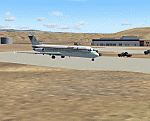
Googly scenery for HCMI Berbera, Somalia - an airport largely overlooked in
Flight Simulator 2004 with just a runway and tower provided at what is actually
the country's largest airport. At one time it had two active runways and a
strong military presence but today activity is limited to occasional
civilian flights. These scenery files add taxiways, aprons, buildings and
other airport features (and remove the non-existent tower that Microsoft
put there) so that you and your "AI" traffic can land, taxi, park and take
off in a realistic manner. This desert-surrounded airport is served three times per week by Douglas DC-9 jets of Kenyan airline African Express Airways.
The scenery does not purport to be ultra-accurate. Based on high-detail satellite
imagery from Google Earth, the layout is proportionally correct but the added
airport features, such as buildings, are built from default Microsoft objects
and add-on libraries so will not look like the real thing.
You are not obliged to download and install any additional scenery libraries,
but to enjoy this scenery in its entirety, you may wish to. It will work fine,
with or without. [File re-uploaded at request of AVSIM]
| Filename: | HCMI_Berbera_Somalia.zip |
| License: | Freeware |
| Added: | 29th May 2010, 09:26:33 |
| Downloads: | 1,317 |
| Author: | John Hinson |
| Size: | 62.07 KB |
| Category: Flight Simulator X - Scenery | |
| Lelystad airport_EHLE_FSX_new_layout |
|
File Description:
Because the Netherlands 2000 Scenery Design Team no longer releases a new version for the FSX,
this version has been compiled based on nl2k_v4_EHLE_5 with the permission of the the Netherlands 2000 Scenery Design Team.
- Various buildings have been modelled and items from various sources have been added to the airport.
- The EHLElib.BGL file contains all the items that have been used and the textures are complete.
As a result, the airport can be installed without the use of the installation of the Netherlands 2000 Scenery Design Team.
- The airport is surrounded by more trees than the version nl2k_v4_EHLE_5.
- Lampposts have been added to the highway of the approach path of Runway 23 and parking places.
- By means of Airport Design Editor the airport can be changed.
- In the Effects folder, there are effects that should be added to the FSX (SE) folder.
- In the selection folder you will find two options. One is the choice where the new section is active and two where it is inactive.
By placing a copy of one of these in the scenery folder and deleting it already in the scenery.
It will become active after you restart the flight sim.
Enjoy and Happy flying
Jan Zijlstra from the Netherlands
| Filename: | Lelystad_airport_EHLE_FSX_new_layout.zip |
| License: | Freeware |
| Added: | 20th March 2024, 23:09:06 |
| Downloads: | 167 |
| Author: | Jan Zijlstra |
| Size: | 255.22 MB |
| Category: Prepar3D V1-4 - Scenery | |
| ENRA - Mo I Rana Rossvoll Airport - Nordland, Norway |
|
Images related to this file:
File Description: The Mo i Rana airport, Rossvoll is a North Norwegian airport in the county of Nordland. It is located about ten kilometers northeast of the city Mo i Rana. Operator of the airport is the Norwegian state-owned company Avinor. The Mo i Rana Airport is currently served only by the Norwegian regional airline Wideroe. Scheduled flights go to an from Bodo, Bronnoysund, Mosjoen, Rorvik, Sandnessjoen and Trondheim. The P3D scenery is a partly rework of my FSX-ENRA scenery: Especially the apron lights are made completely new.
The environment of the airport is adapted by new landclasses. The airport has a photo background in two variants, covering all four seasons of spring,summer, autumn and winter. The buildings in this scenery come from the fantastic XPlane scenery of Bert alias "almosquito" who kindly gave me the permission to convert them for my FSX /P3D scenery. But there are also some objects taken from two very popular freeware libraries. If these libraries are not installed, several objects are not visible! Please have a look to the readme_enra.txt. The screenshots are taken from the FSX version. But the P3D version looks quite similar.
| Filename: | ENRA__Mo_I_Rana_Rossvoll_Airport__Nordland_Norway.zip |
| License: | Freeware |
| Added: | 2nd April 2019, 18:48:29 |
| Downloads: | 542 |
| Author: | Wolfgang Allers |
| Size: | 155.53 MB |
| Category: Flight Simulator X - Scenery | |
| ENRA - Mo I Rana Rossvoll Airport - Nordland, Norway |
|
Images related to this file:
File Description:
The Mo i Rana airport, Rossvoll is a North Norwegian airport in the county of Nordland. It is located about ten kilometers northeast of the city Mo i Rana. Operator of the airport is the Norwegian state-owned company Avinor.
The Mo i Rana Airport is currently served only by the Norwegian regional airline Wideroe. Scheduled flights go to an from Bodo, Bronnoysund, Mosjoen, Rorvik, Sandnessjoen and Trondheim.
The FSX scenery:
The environment of the airport is adapted by new landclasses.
The airport has a photo background in two variants, covering all four seasons of spring, summer, autumn and winter.
The buildings in this scenery come from the fantastic XPlane scenery of Bert alias"almosquito" who kindly gave me the permission to convert them for my FSX scenery.
But there are also some objects taken from two very popular freeware libraries.
If these libraries are not installed, several objects are not visible!
The following libraries are used:
1. FS-Piloten_Objektlibrary:
http://www.fs-piloten.de/thread.php?threadid=1063
2. FSX_FlightPortLib
http://www.flightport.de/libraries/flightport-library/
Basically, libraries should be well integrated into the hierarchy of the Scenery.cfg, even below the Add-On-scenery because the Library objects otherwise may not be found by FSX.
| Filename: | ENRA__Mo_I_Rana_Rossvoll_Airport__Nordland_Norway.zip |
| License: | Freeware |
| Added: | 1st August 2015, 21:40:11 |
| Downloads: | 1,513 |
| Author: | Wolfgang Allers |
| Size: | 9.44 MB |


© 2001-2026 AVSIM Online
All Rights Reserved
Privacy Policy |