
Where Flight Simulation Enthusiasts Gather from Around the World!
AVSIM Library - Search Results

| Category: Flight Simulator 2002 - Utilities | |
| Jetplan 767 v4 |

|
File Description:
The ultimate Flight Despatcher all in 3 minutes!
Calculate your fuel from the mileage and winds to airline standards, take the minimum or tanker. Get ZFW, TOW from average passenger weights including baggage and extra cargo. From these get VRef, V1 VR and V2 and take-off power N1 from the pressure altitude and temp for full, derate-1 and derate-2. Then print
out on the reverse of your flight log.
NOW comes with TAKE-OFF PERFORMANCE. Can you get a full load of passengers out of Denver with a temperature of 30 degree centigrade all the way to Paris without a tech stop for fuel? Find out. Just enter the Pressure Altitude, temperature, runway slope and wind component and you will get a FIELD LENGTH weight figure for that runway, No problem? Good, now look at the CLIMB PERFORMANCE tables below it... whoops!
JETPLAN : REAL DATA-REAL SIMULATION! This program requires MS Excel!
| Filename: | Jetplan_767_v4.zip |
| License: | Freeware |
| Added: | 23rd June 2002, 09:57:11 |
| Downloads: | 1,152 |
| Author: | Mike Jamieson |
| Size: | 49.67 KB |
| Category: Flight Simulator 2004 - Scenery | |
| Canadian and Northern USA Winter Flying |
|
File Description:
This is an expanded version of a previous post a year ago, and stretches from east of Quebec City through Quebec, Ontario, and Manitoba, and now also through Saskatchewan, and into Alberta (past Calgary). There is also a northern area roughly centered on Hudson Bay. The exact coverages are given in the notes. All rivers and lakes within the area will "freeze" and allow ski planes to land, or even wheeled planes come to that. And it is not permanent, when you want to go back to floats just "untick" it in the FS library, and it will melt. The area covered crosses into the US too, down to around 45 degrees north, so that means most of Montana, all of North Dakota, half of Minnesota, and some of Wisconsin, Michigan etc. It seemed silly to stop at the border. Ultimate Terrain is highly recommended, so that there will actually be the right lakes and rivers ready to freeze.
| Filename: | Canadian_and_Northern_USA_Winter_Flying.zip |
| License: | Freeware |
| Added: | 26th May 2008, 13:24:29 |
| Downloads: | 669 |
| Author: | Roger Wensley |
| Size: | 354.86 KB |
| Category: Flight Simulator 2004 - Scenery | |
| KSGU-Saint George, Utah |
|
File Description:
The 6600' long St. George airport in southwestern Utah sits high on a mesa! You grasp your armrest hoping that you will become airborne before you fall off the cliff...Or just after landing you are nervously waiting for the pilot to apply the brakes as the end of the runway rushes up to meet you before you fall into nothingness! Such is the fate that awaits the pilot or passenger that ventures to the Saint George, Utah airport.
Actually, it is a very safe and delightful airport to base your flights from. Visit Southern Utah and see the many sights that await the adventurous soul. Take a trip from KSGU to Moab-KCNY or KVEL and marvel at the diversity of the landscape. ( I upgraded those 2 airports also.)
While designed for use with Ultimate Terrain, this enhancement should work with the default FS2004 setting. Please unzip to a temporary folder and follow the simple installation instructions.
| Filename: | KSGUSaint_George_Utah.zip |
| License: | Freeware |
| Added: | 23rd August 2008, 09:49:58 |
| Downloads: | 1,411 |
| Author: | Alan C. Heiner |
| Size: | 664.81 KB |
| Category: Flight Simulator X - Scenery | |
| Bella Coola Valley Landscape Enhancements |
|
File Description:
One of the most spectacular watersheds of British Columbia's Midcoast, the Bella Coola Valley looks pretty boring in its default FSX rendition and the oddly shaped default Bella Coola River cuts deep into the terrain. These files provide a terrain mesh made from CDED1 0.75-arcsec data (multi-LOD, with maximum resolution of 38-m grid spacing), updated land class, water class, and seasons files, and accurate placements of lakes, rivers, streams, roads, and bridges. Also added are the glaciers of the Monarch Mountain Icefield as well as several forestry roads and clearcuts in the side valleys. Main roads have vehicle traffic moving in both directions. Coverage area is N51*45'-52*40' and W125*35'-127*25'. These files are fully compatible with other landscape enhancements for FSX, such as FS Genesis North America terrain mesh, Cloud 9's X-class, Adam Mill's ground texture replacements, or Flight1's Ultimate Terrain Canada/Alaska.
| Filename: | Bella_Coola_Valley_Landscape_Enhancements.zip |
| License: | Freeware, limited distribution |
| Added: | 24th February 2007, 08:27:54 |
| Downloads: | 12,654 |
| Author: | Holger Sandmann |
| Size: | 15.68 MB |
| Category: Flight Simulator 2004 - Scenery | |
| AI Tall Ships sailing on Long Island Sound |
|
Images related to this file:
File Description:
AI Tall Ships sailing on Long Island Sound - A gathering of ten vintage AI Sailing Ships near Fisher's Island, New York. This scenery features incredibly detailed AI Sailing Ships modeled by Ron Jeffers, Pierre de Rotalier and Mike Hill. The project includes a replica of the Pequod - Captain Ahab's whaling ship in the epic novel "Moby Dick". Eight of the ten ships make twice daily trips around Fisher's Island. There is also an animated naval rowboat which makes short demonstration runs daily. With one exception, all required files are included. This scenery has been tested with Ultimate Terrain and the FS2004 default environment. Please unzip to a temporary folder and follow the simple, illustrated instructions. Then sit back, watch the seas come to life and relive a little history. This package works very well with John B.Loney's Elizabeth Airport - 0b8_v1.zip - available here. Compiled for your flying (and sailing) enjoyment by David "Opa" Marshall.
| Filename: | AI_Tall_Ships_sailing_on_Long_Island_Sound.zip |
| License: | Freeware |
| Added: | 10th December 2009, 12:42:56 |
| Downloads: | 2,382 |
| Author: | David "Opa" Marshall |
| Size: | 21.05 MB |
| Category: Flight Simulator 2004 - Aircraft Repaints, Textures and Modifications | |
| DFG Convair CV-240 VBF CA-18 |
|
Images related to this file:
File Description:
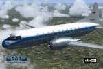
FS2004 DFG Convair CV-240 VBF CA-18 in 1959 colors of Deutsche Flugdienst GmbH (German Flight Service Corporation), delivered to KLM Royal Dutch Airlines on August 31, 1948,
named "Albert Cuyp" and registered PH-TEC. Reregistered PH-CEC on March 2, 1954. Bought
by Deutsche Flugdienst GmbH on November 27, 1957 and registered D-BEPE. Sold to Houston Aviation Products on November 3, 1961 and registered N13648. Bought by Ozark Airlines on July 2, 1962 and registered N2400Z. Bought by Mohawk Airlines on December 23, 1964. Reregistered to Mohawk Airlines Delaware with registration N8327C on January 27, 1965. After this the Convair was operated by several companies and private owners. Last known action was taken at 2000-04-13. Ultimate fate is unknown. Textures and associated model file included only. Requires cv240VBFca18_basepack_010.ZIP. Original by Greg
Pepper & Tom Gibson, upgraded by Georg Hauzenberger (model) and Hans Hermann (textures) Virtual Birds Factory, November 2010
| Filename: | DFG_Convair_CV240_VBF_CA18.zip |
| License: | Freeware, limited distribution |
| Added: | 1st December 2010, 01:00:09 |
| Downloads: | 414 |
| Author: | Georg Hauzenberger and Hans Hermann |
| Size: | 5.15 MB |
| Category: Flight Simulator X - Scenery | |
| CYCD (2012) Version 3 for FS9, FSX and Prepar3D |
|
Images related to this file:
File Description:
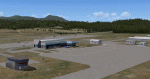
CYCD (2012) is an update to Ken Peter's CYCD Nanaimo-Collishaw Airport (Vancouver Island, British Columbia, Canada). The airport has recently completed a major runway
extension and installed an ILS for Rwy 16. The five flashing-red beacons that guide the way on a night approach to Rwy 34 are included. To the extent possible, this update
reuses Ken's custom buildings and objects (but you don't need to have Ken's version installed). As well, a selection of SAMM-generated static aircraft are scattered around the
aprons supplemented by a number of AI aircraft that do touch 'n gos from time to time. CYCD (2012) is compatible with ORBX FTX USA Canada Pacific Northwest and both versions
of Ultimate Terrain.
Generally, this new version is visually identical to its predecessor - even though quite different internally. As well, to the extent possible, it is compatible with
Prepar3Dv2. (v3.03 fixes a vehicle texture issue in 3.02)
| Filename: | CYCD_2012_Version_3_for_FS9_FSX_and_Prepar3D.zip |
| License: | Freeware |
| Added: | 22nd June 2014, 17:18:09 |
| Downloads: | 3,987 |
| Author: | Don Grovestine |
| Size: | 64 MB |
| Category: Flight Simulator 2004 - Scenery | |
| Pete & Sid's Viva Scenery Volume 4 |
|
File Description:
This is a collection of scenery enhancements for 81 airports, mostly smaller ones, located primarily in the Pacific Northwest, Alaska and Western Canada. (Yes, there's one in New Zealand.) It was not our intention to do anything fancy or particularly accurate, but simply to make the default scenery less boring and more fun. General aviation AI traffic (using default FS9 aircraft) is also included for some of these airports. The scenery for any individual airport may be removed without affecting the other airports. Some the airports we've done may also be included in Glacier Bay and other scenery add-ons; you'll need to remove one or the other to resolve any conflicts. This scenery was designed to work with Flight1's Ultimate Terrain and has not been tested with the default FS9 scenery. Most of the airports will probably work fine with the default scenery; those airports near water features (lakes, rivers, coastlines) are the ones most likely to have problems.
| Filename: | Pete__Sids_Viva_Scenery_Volume_4.zip |
| License: | Freeware |
| Added: | 12th July 2008, 13:22:06 |
| Downloads: | 2,256 |
| Author: | Sidney Schwartz & Peter Ham |
| Size: | 1.03 MB |
| Category: Flight Simulator 2004 - Scenery | |
| Beaver Creek CYXQ 1.1 |
|
Images related to this file:
File Description:
Version 1.1 adds the missing door on the ground side of the terminal building. It is complete and does not require that you already have the previous version.
Beaver Creek CYXQ is a small airport in the northern Canada Yukon Territory, near the Alaskan border. There is a customs facility located on the Alaska Highway adjacent to the airport. There is an NDB located on the field, but no published instrument approaches. The single gravel runway is 3740'long.
This scenery was completely redone and features a custom photoreal terminal and custom runway/taxiway lights. The adjacent customs facility is included but is not based on the real one as I had no photos to work from. The custom runway lights are always on, even during the day...sorry, this is an FS9 limitation.
This scenery was designed for use with Ultimate Terrain and was not tested in the default scenery. It may or may not work in FSX.
| Filename: | Beaver_Creek_CYXQ_11.zip |
| License: | Freeware |
| Added: | 6th November 2010, 22:31:24 |
| Downloads: | 914 |
| Author: | Sidney Schwartz & Peter Ham |
| Size: | 447.05 KB |
| Category: Flight Simulator 2004 - Scenery | |
| Williams Lake CYWL |
|
Images related to this file:
File Description:
Founded in 1860, Williams Lake is located in the beautiful central British Columbia region known as the Cariboo. With a population of about 11,000, Williams Lake is the largest urban center between Kamloops and Prince George. The airport has one 7,000' (2,100m) runway and is served by Central Mountain Air and Pacific Coastal Airways.
This complete rebuild of CYWL features all new taxiways, aprons and buildings, an accurate custom terminal building, and the usual fences, trees, ramp objects, etc. Many thanks to Shawn Lund, Air Attack Officer, BC Wildfire Management Branch, Kamloops Fire Centre, for the photos of the terminal building and his permission to use them. Included are the Nav Canada aerodrome diagram and the two instrument approach plates. (These approach plates are out of date and obviously NOT for real world use.)
This scenery was designed for use with Ultimate Terrain and was not tested in the default scenery. It may or may not work in FSX.
| Filename: | Williams_Lake_CYWL.zip |
| License: | Freeware |
| Added: | 21st December 2010, 07:17:50 |
| Downloads: | 1,073 |
| Author: | Sidney Schwartz & Peter Ham |
| Size: | 2.07 MB |


© 2001-2026 AVSIM Online
All Rights Reserved
Privacy Policy |