
Where Flight Simulation Enthusiasts Gather from Around the World!
AVSIM Library - Search Results

| Category: Flight Simulator X - Scenery | |
| Sardinia Photoreal 5/14 - La Maddalena Archipelago National Park |

|
Images related to this file:
File Description:

Photoreal coverage of La Maddalena Archipelago National Park.
Credits: Aerial photos summer 2012 courtesy of Microsoft Virtual Earth.
| Filename: | Sardinia_Photoreal_514__La_Maddalena_Archipelago_National_Park.zip |
| License: | Freeware |
| Added: | 15th June 2013, 20:45:46 |
| Downloads: | 2,539 |
| Author: | Diego Paparella |
| Size: | 28.6 MB |
| Category: Flight Simulator 2004 - Flight Plans | |
| Zambia Airways Hawker Siddeley HS 748 |
|
File Description:
This Hawker Siddeley HS 748 was used by Zambia Airways for Domestic flight schedules to Ndola, Kitwe, Chipata, Kasama, Livingstone [ were Victoria falls is ] Mfuwe [ Luangwa Game Park ], Mongu, Kafue National Park, etc.
| Filename: | Zambia_Airways_Hawker_Siddeley_HS_748.zip |
| License: | Freeware |
| Added: | 9th June 2005, 02:57:25 |
| Downloads: | 472 |
| Author: | Dee Waldron, Bashir Ismail |
| Size: | 1.13 MB |
| Category: Flight Simulator 2004 - AI Aircraft | |
| Zambia Airways Hawker Siddeley HS 748 |
|
File Description:
This Hawker Siddeley HS 748 was used by Zambia Airways for Domestic flight schedules to Ndola, Kitwe, Chipata, Kasama, Livingstone [ were Victoria falls is ] Mfuwe [ Luangwa Game Park ], Mongu, Kafue National Park, etc.
| Filename: | Zambia_Airways_Hawker_Siddeley_HS_748.zip |
| License: | Freeware |
| Added: | 10th June 2005, 00:31:58 |
| Downloads: | 667 |
| Author: | Dee Waldron, Bashir Ismail |
| Size: | 1.13 MB |
| Category: Flight Simulator 2004 - Scenery | |
| Weaver MT54 Montana USA |
|
Images related to this file:
File Description:
I made this because I downloaded and tried the Glacier Park scenery by Blue Sky Scenery and then discovered that the airfield runways are not always correctly positioned or aligned. So I moved the Weaver runway over and added a couple of buildings. That's it, almost the same as I did for Whitefish. If I find some more airfields in this area with similar problems then I'll do more of the same. Weaver is a private field 4 miles south of Glacier Park International at 2,929 feet ASL and around 45 miles south of the Canadian border. There are no large towns close by; the nearest would be Missoula, which is some 90 miles further south.
| Filename: | Weaver_MT54__Montana_USA.zip |
| License: | Freeware, limited distribution |
| Added: | 26th May 2010, 03:18:46 |
| Downloads: | 203 |
| Author: | Roger Wensley |
| Size: | 14.23 MB |
| Category: Flight Simulator 2004 - Scenery | |
| Joshua Tree + San Bernardino Mountains, California 38m Terrain Mesh |
|
File Description:
USGS SRTM30 1 arc-second, resampled to LOD10 (38.2 meters). This terrain mesh is centered at Joshua Tree National Park in southern California. Coverage area: From West 115.1° to West 117.4° and North 33.7° to North 34.3°. It includes the National Park, the Palm Springs area with Mount San Jacinto and the San Bernardino Mountains.
| Filename: | Joshua_Tree__San_Bernardino_Mountains_California_3.zip |
| License: | Freeware, limited distribution |
| Added: | 4th January 2004, 21:05:58 |
| Downloads: | 3,715 |
| Author: | Andreas Trawny |
| Size: | 4.57 MB |
| Category: Fly! II - Scenery | |
| Grand Canyon National Park Airport (KGCN) |
|
File Description:
TerraModels Scenery Development System by Allen Kriesman and Biber Salsa models were used to create the scenery for Grand Canyon National Park Airport (KGCN). The taxiways were added using the program by Peter Jacobson. This is not an exact replica of the airport. Taxiways are included along with taxiway and runway signs.
| Filename: | Grand_Canyon_National_Park_Airport_KGCN.zip |
| License: | Freeware |
| Added: | 10th August 2002, 23:10:23 |
| Downloads: | 492 |
| Author: | Wayne Roberts |
| Size: | 655.55 KB |
| Category: Flight Simulator X - Scenery | |
| Angel Falls, Canaima National Park, Venezuela |
|
Images related to this file:
File Description:
Angel Falls, Canaima National Park, Venezuela. Discovered in 1933 by an American pilot, Jimmie Angel, Angel Falls is located on Auyan Tepui near Canaima (SVCN). It's the world's highest waterfall with a height of 979 meters. See the readme text for more information about installation and required meshes.
| Filename: | Angel_Falls_Canaima_National_Park_Venezuela.zip |
| License: | Freeware, limited distribution |
| Added: | 13th February 2010, 14:27:54 |
| Downloads: | 1,856 |
| Author: | Jean St-Cyr |
| Size: | 17.91 KB |
| Category: Flight Simulator X - Scenery | |
| Death Valley National Park - California, USA |
|
Images related to this file:
File Description:
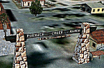
FSX Scenery--Death Valley. This scenery covers several areas of Death Valley National Park (CA). See the World's lowest golf coarse at Furnace Creek Ranch, the moving rocks at the RaceTrack, Scotty's Castle, Panamint Spring, and Stovepipe Wells. Custom designed buildings with photorealistic textures, night textures, and satellite image for the grounds. This scenery has been tested on FSX Gold Edition (FSX Deluxe and Acceleration Expansion Pack), FSGenesis 9.6 terrain mesh, and Win7 operating system. Requires RWEOBJv5.zip & RWEOBJc5.zip (or later) Object Libraries. By Ron Ezra.
| Filename: | Death_Valley_National_Park__California_USA.zip |
| License: | Freeware |
| Added: | 13th January 2016, 22:23:10 |
| Downloads: | 456 |
| Author: | Ron Ezra |
| Size: | 5.53 MB |
| Category: Flight Simulator X - Scenery | |
| Jeki Airstrip (FLJK) - Zambia |
|
Images related to this file:
File Description:
Photoreal Scenery of Jeki Airstrip.
The airstrip is located in Zambia at Lower Zambezi National Park and mainly used to bring tourists and game hunters into the park. It is also commercially used by Proflight Zambia.
For FSX only!
| Filename: | Jeki_Airstrip_FLJK__Zambia.zip |
| License: | Freeware |
| Added: | 21st June 2012, 18:09:33 |
| Downloads: | 541 |
| Author: | Jens Weissflog |
| Size: | 1.23 MB |
| Category: Flight Simulator 2002 - Flight Plans | |
| U.S. National Parks 1.0 |
|
File Description:
This series of flights -- for those who like hands-on, low and slow pilotage -- takes you sightseeing over all 55 U.S. National Parks, plus Virgin Islands National Park, in a Cessna 172SP. No flight plans here -- just briefings on each park, one suggested tour through each park, plus flight and weather files for each park to get you started. (Print out the briefings or open the .BRF files in Notepad during your flights.) The parks are beautiful with a basic FS2K2 installation, but with the FSGenesis 38.2m and/or 9.6m enhanced terrain meshes, they can be spectacular.
| Filename: | US_National_Parks_10.zip |
| License: | Freeware |
| Added: | 16th October 2002, 11:43:25 |
| Downloads: | 999 |
| Author: | Dick Muldoon |
| Size: | 398.22 KB |
© 2001-2026 AVSIM Online
All Rights Reserved
Privacy Policy |