
Where Flight Simulation Enthusiasts Gather from Around the World!
AVSIM Library - Search Results

| Category: Flight Simulator X - AFCAD Files | |
| Flying W Airport (N14), NJ |

|
File Description:
Located 01 miles SW of Lumberton, New Jersey on 170 acres of land, Flying W Airport services small to medium GA aircraft as well as helicopters. Transient storage are tie downs only. There are plenty of places to park. The main parking area in on the west side of the airport on the south end of the north tarmac and can handle wingspans of up to 50 feet. You can also park slightly north among the static aircraft or east of the runway on the grass. Collisions are disabled with static craft in these areas to assist with parking. Both 100LL and Jet-A are available by stopping at the south tarmac next to the fuel tank or the north tarmac by the fuel trucks in front of the terminal. Trees are summertime ONLY.
Scenery constructed with use of satellite images/streetview, the author has not been there in person.
This scenery is meant to be used in conjunction with MegaScenery Earth New Jersey/Delaware 002. It is not required, but apron use is minimized to allow satellite scenery to show through as much as possible, and objects are placed based on the MSE textures - lack of it may make scenery look out of place.
| Filename: | Flying_W_Airport_N14_NJ.zip |
| License: | Freeware |
| Added: | 24th October 2010, 18:53:47 |
| Downloads: | 217 |
| Author: | Drew Sikora |
| Size: | 805.7 KB |
| Category: Flight Simulator 2004 - Scenery | |
| TNCS - Juancho E. Yrausquin Airport - Saba, Netherlands Antilles |
|
Images related to this file:
File Description:
This island is the smallest municipality of the Netherlands. Saba is just under 30 miles south of St. Maarten, the island that was split between France and the Netherlands; to the southeast and 20 miles away is the small island of St. Eustatius, then St Kitts and then Nevis. The island comes out of the water like the top of Everest and keeps going, and there is no large space for a runway and no possibility of creating one with landfill with those steep sea cliffs. So what you have is a small runway (aligned 12/30) of 1,000 feet plus over-runs at each end that have small "closed" markings (see the white crosses) for a usable total of around 1,300 feet.
The airport restricts access as there is only space for four planes to park, plus a helicopter. And of course there is also the short runway to contend with. Landings are carried out under waivers issued by the Netherlands Civil Aviation Authority, and will always be on runway 12 as the southeast trade winds predominate. Twotters land there but only in real life; FS9 AI Twotters don't seem to find it adequate. There is no fuel or any other facility except for a small terminal building and a car park.
| Filename: | TNCS__Juancho_E_Yrausquin_Airport__Saba_Netherland.zip |
| License: | Freeware, limited distribution |
| Added: | 8th May 2013, 02:52:26 |
| Downloads: | 1,500 |
| Author: | Roger Wensley |
| Size: | 3.09 MB |
| Category: Flight Simulator 2004 - Scenery | |
| Updates for Rockcliffe CYRO in Ottawa Canada |
|
Images related to this file:
File Description:
Flight Ontario posted their scenery for CYRO in 2008. I originally learned to fly at Rockcliffe Flying Club and came up with some additions and modifications in 2009, and now with the passage of time there are more changes. This version replaces the previous updates and is a self-contained version.
A mini tornado in 2009 destroyed the old willow tree and almost put paid to the clubhouse too (though all the buildings are still standing right now) so there is a new (temporary) clubhouse, a new hangar, the willow tree is gone, the car park is enlarged and is now asphalt, the fence line is revised and the entrance gate relocated. The previous modifications included the refueling point near the RFC buildings, revised apron shape, gravel car park, parked cars, extended perimeter fence, deck in front of the RFC clubhouse, more parked planes, the large and old willow tree, and the float dock in the river. Note in the winter picture the Ottawa River is frozen, as it is right now in reality, and you can download my "Frozen Lakes etc" post and turn your own Canadian winter into reality; I have been surprised by how few people are interested in winter flying in FS9.
| Filename: | Updates_for_Rockcliffe_CYRO_in_Ottawa_Canada.zip |
| License: | Freeware, limited distribution |
| Added: | 5th March 2010, 18:05:35 |
| Downloads: | 569 |
| Author: | Roger Wensley |
| Size: | 2.43 MB |
| Category: Flight Simulator 2004 - AI Aircraft | |
| 123rd FIS 142nd FIG Oregon Air National Guard McDonnell-Douglas F-4C Phantom |
|
File Description:
Twenty-four repaints of the F-4C Phantoms belonging to the 123rd Fighter Interceptor Squadron, 142nd Fighter Interceptor Group from Portland International. Textures only for the F-4C Phantom Version 2 by Nick Black and Michael Pearson. Model can be found on AVSIM.
| Filename: | 123rd_FIS_142nd_FIG_Oregon_Air_National_Guard_McDo.zip |
| License: | Freeware |
| Added: | 13th March 2013, 06:14:59 |
| Downloads: | 327 |
| Author: | Jason Rogers |
| Size: | 6.33 MB |
| Category: Flight Simulator 2004 - AI Aircraft | |
| RF-4C Phantom 189th TRTF/190th TRS, 124th TRG "Idaho Air National Guard" |
|
File Description:
Thirty-three repaints of the RF-4C Phantom in the colors of the 189th TRTF/190th TRS, 124th TRG, Idaho ANG at Boise. For the Nick Black RF-4E model.
| Filename: | RF4C_Phantom_189th_TRTF190th_TRS_124th_TRG_Idaho_A.zip |
| License: | Freeware |
| Added: | 23rd May 2012, 04:32:33 |
| Downloads: | 267 |
| Author: | Jason Rogers |
| Size: | 5.44 MB |
| Category: Flight Simulator 2004 - Scenery | |
| Grand Staircase Escalante National Monument/East, Escalante (1L7), Utah, Photo-Scenery (FS9 & FSX) |
|
Images related to this file:
File Description:
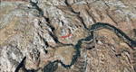
This scenery contains the eastern part of the Grand Staircase Escalante National Monument. It extends from the town of Escalante down south where it connects with the Page/Lake Powell scenery. Contains the upper part of wonderful Escalante Canyon. To explore the scenery depart from Escalante Airport (1L7). Thanks to Joop Mak for providing a custom AFCAD that corrects the airport layout so that it matches with the photo-textures! High resolution versions of this scenery for FS9 and FSX (much sharper, but larger and multiple downloads) are available at www.blueskyscenery.com/CNY_South2West3.html . The screenies are taken from the high-res versions, so expect this version to be slightly more blurry. YourDonation@Work: Dedicated to Jay, Donald and Franz
| Filename: | Grand_Staircase_Escalante_National_MonumentEast_Es.zip |
| License: | Freeware, limited distribution |
| Added: | 4th March 2010, 22:44:30 |
| Downloads: | 1,488 |
| Author: | Gottfried Razek - blueskyscenery.com |
| Size: | 96.2 MB |
| Category: Flight Simulator X - Scenery | |
| Kiwi360 (KiwiFruit Country)- Custom buildings, helipad, Hi Res photoreal, Aerius R22 Repaint. Te Puke, New Zealand |
|
File Description:
Kiwi360 (formally know as Kiwifruit Country) is a theme park based around the Kiwifruit (AK.A Chinese Gooseberry or Zespri- The trade name) which is a major export of New Zealand grown predominately in the Bay of Plenty Region. The park is situated about midway between Tauranga and Whakatane, about 5km east of the township of Te Puke.
The Bay of Plentys sunny climate ensures good growing conditions for the delicious fruit and has also spawned a mini tourist industry of tours of the orchards and sorting/packing/coolstores. These include tourist flights by Aerius (http://www.aerius.co.nz ) using a Robinson R44 helicopter.
This scenery was made after a visit when carrying out a GPS survey: I took a few photos and whacked it up. It isn't perfect but will be useful for flights in small helos (I.e. Robinson R22, R44 or Hughes 300/269).
It includes the famous giant Kiwifruit slice, the helipad next to it; the main Kiwi 360 building; a large coolstore/packhouse and the backpackers next to the park. It also includes a lot of library objects (especially trees- If these are adversely affecting performance, you can disable this bgl)
This is placed on a high resolution aerial photo provided by Environment Bay of Plenty.
The scenery also has reflection maps and night maps for those who like getting up at the crack of dawn or simulating frost protection work (although I don't believe the pad is certified for night operations in real life).
The download also includes a repaint of the default Robinson R22 in the colours of ZK-HJZ (in actual fact an R44) kindly provided by James Eden from the ARNZ Forums (see the readme for the .cfg entry to add this repaint)
This helipad isn't in controlled airspace but Tauranga Tower is nearby and will need to be called before entering their airspace (above 2500ft LL for the CTA or within about 10nm of Tauranga for the CTZ) Radio procedures are carried out on Christchurch Information 125.5 for flight following/planning.
| Filename: | Kiwi360_KiwiFruit_Country_Custom_buildings_helipad.zip |
| License: | Freeware, limited distribution |
| Added: | 29th June 2008, 06:05:29 |
| Downloads: | 2,455 |
| Author: | Tim Barnes, James Eden |
| Size: | 11.63 MB |
| Category: Flight Simulator X - AFCAD Files | |
| Albany Airport, Western Australia YABA |
|
File Description:
Albany Airport serves the town of Albany, Western Australia. It is located six miles North of the town. It is also known as Harry Riggs Albany Airport. It serves 56,000 passengers a year.
I have used ADEX and Google Earth plus available charts to modify the stock airport in FSX. Added aircraft parking according to the charts. And some static models within the maintenance areas.
You should download the brilliant car park package by Sidney Schwartz, modified my Martin Gossman at Owls Nest. Also the great lights package by Jim Dhaenens. Both can be found on AVSIM and other good flight sim libraries.
| Filename: | Albany_Airport_Western_Australia_YABA.zip |
| License: | Freeware |
| Added: | 18th April 2018, 23:53:00 |
| Downloads: | 580 |
| Author: | Mike Major |
| Size: | 2.44 MB |
| Category: Flight Simulator X - Scenery | |
| Katies Lagoon |
|
Images related to this file:
File Description:

katies Lagoon is fictitous and located east of Kalispell on the north shore of Flathead Lake. it has a float plane dock, marinas, cabin rentals, a water runway and NDB with a frequency of 224.0 with a range of 55 nautical miles. Shows on GPS and has start points. Includes a landable helipad and many objects throughout the area. It's a lagoon, campground and ATV park. There will be a version 2 coming soon which will upgrade areas for RV's and ATV's. Read the text file and PLEASE enjoy! Designed with a clean install of FSX and to enhance your FSX world. Savageagle.
| Filename: | Katies_Lagoon.zip |
| License: | Freeware |
| Added: | 17th August 2010, 00:46:34 |
| Downloads: | 301 |
| Author: | Tim Durham |
| Size: | 705.42 KB |
| Category: Flight Simulator 2004 - AFCAD Files | |
| Aerosoft's Antalya FS9 yet another update! |
|
Images related to this file:
File Description:

Updated (for about the 10th time, in my sim anyway!) version of Aerosofts beautiful Antalya scenery for FS9. All the correct Airlines are assigned to Terminal 1, the Domestic Terminal and Terminal 2 with larger radius so they can handle anything up to B747's, Il-86's and so on. I'm afraid I had quite a few Airlines at the wrong Terminals and thought the only real way to find out where they park is by visiting the Antalya website (daily), which gives out the Terminal for passengers to check in so I am sure now it's pretty accurate.
| Filename: | Aerosofts_Antalya_FS9_yet_another_update.zip |
| License: | Freeware |
| Added: | 14th November 2010, 18:25:54 |
| Downloads: | 796 |
| Author: | Billy Rutherford |
| Size: | 20.7 KB |


© 2001-2026 AVSIM Online
All Rights Reserved
Privacy Policy |